Browse Listings
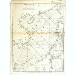
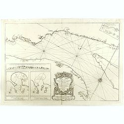
A general chart of the China Sea : drawn from the journals of the European navigators, particularly from those collected by Capt. Hayter.
A scarce and detailed showing China Sea with Taiwan, western part of the Philippines, northern part of Borneo and the coast of South China with Cochinchina. Latitude and...
Date: London, 1778
Selling price: ????
Please login to see price!
Sold in 2013
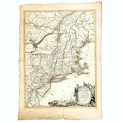
Carte du Theatre de la Guerre actuel entre les Anglais et les Trieze Colonies Unies de l'Amerique Septentrionale dresse par J.B. Eliot
A fine example of J. B. Eliot's map of the United States, in its first state - which is generally regarded as the earliest map to include the title "United States&qu...
Date: Paris, 1778
Selling price: ????
Please login to see price!
Sold in 2015
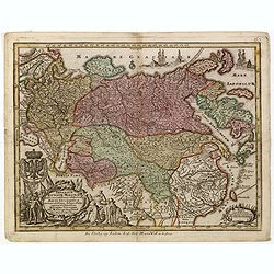
Imperium Russiae Magnae. . .
Miniature map of Russia, a reduction of the appropriate part of Seutter's folio map.From Atlas Minor, here published by Johann Martin Will, with his address in bottom cen...
Date: Augsburg, J.M.Will, 1778
Selling price: ????
Please login to see price!
Sold in 2015
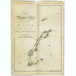
The Magdalen-Isles in the Gulph of St. Lawrence.
A chart of part of Canada taken from the "Atlantic Neptune", and marked in lower right corner "Published according to Act of Parliament Jan. The 20th 1778 ...
Date: London, 1778
Selling price: ????
Please login to see price!
Sold in 2015
![[Miramichi Bay]](/uploads/cache/35775-250x250.jpg)
[Miramichi Bay]
A chart of part of Canada taken from the "Atlantic Neptune", and marked in lower right corner "Published according to Act of Parliament Jan. The 20th 1778 ...
Date: London, 1778
Selling price: ????
Please login to see price!
Sold in 2015
![[Harbour and bay of Gaspee]](/uploads/cache/35776-250x250.jpg)
[Harbour and bay of Gaspee]
A chart of part of Canada taken from the "Atlantic Neptune", and marked in lower right corner "Published according to Act of Parliament Jan. The 20th 1778 ...
Date: London, 1778
Selling price: ????
Please login to see price!
Sold in 2015
![[The south east coast of the island of St John]](/uploads/cache/35777-250x250.jpg)
[The south east coast of the island of St John]
A chart of part of Canada taken from the "Atlantic Neptune", and marked in lower right corner "Published according to Act of Parliament Jan. The 20th 1778 ...
Date: London, 1778
Selling price: ????
Please login to see price!
Sold in 2015
![[Carigan Bay]](/uploads/cache/35778-250x250.jpg)
[Carigan Bay]
A chart of part of Canada taken from the "Atlantic Neptune", and marked in lower right corner "Published according to Act of Parliament Jan. The 20th 1778 ...
Date: London, 1778
Selling price: ????
Please login to see price!
Sold in 2015
![[Bay of Seven islands]](/uploads/cache/35779-250x250.jpg)
[Bay of Seven islands]
A chart of part of Canada taken from the "Atlantic Neptune", and marked in lower right corner "Published according to Act of Parliament Jan. The 20th 1778 ...
Date: London, 1778
Selling price: ????
Please login to see price!
Sold in 2015
![[Bay of Chaleurs]](/uploads/cache/35780-250x250.jpg)
[Bay of Chaleurs]
A chart of part of Canada taken from the "Atlantic Neptune", and marked in lower right corner "Published according to Act of Parliament Jan. The 20th 1778 ...
Date: London, 1778
Selling price: ????
Please login to see price!
Sold in 2015
![[A chart of the N.E.Coast of Cape Breton Island]](/uploads/cache/35781-250x250.jpg)
[A chart of the N.E.Coast of Cape Breton Island]
A chart of part of Canada taken from the "Atlantic Neptune", and marked in lower right corner "Published according to Act of Parliament Jan. The 20th 1778 ...
Date: London, 1778
Selling price: ????
Please login to see price!
Sold in 2015
![[The south east coast of Cape Breton Island]](/uploads/cache/35782-250x250.jpg)
[The south east coast of Cape Breton Island]
A chart of part of Canada including fort Louisbourg, taken from the "Atlantic Neptune", and marked in lower right corner "Published according to Act of Par...
Date: London, 1778
Selling price: ????
Please login to see price!
Sold in 2015
![[The south east coast of Cape Breton Island]](/uploads/cache/35783-250x250.jpg)
[The south east coast of Cape Breton Island]
A chart of part of Canada taken from the "Atlantic Neptune", and marked in lower right corner "Published according to Act of Parliament Jan. The 20th 1778 ...
Date: London, 1778
Selling price: ????
Please login to see price!
Sold in 2015

A Jew Rabbi or King Uzziah
An important mezzotint print by William Pether after a 1635 painting by Rembrandt. While some have identified the sitter simply as a Rabbi, others have linked him to King...
Date: London, 1778
Selling price: ????
Please login to see price!
Sold in 2015
![[ Moose à Becky's Beach - Maine]](/uploads/cache/36364-250x250.jpg)
[ Moose à Becky's Beach - Maine]
A chart of part of Maine's coast line taken from the "Atlantic Neptune", and marked in lower right corner "Published according to Act of Parliament April 2...
Date: London, 1778
Selling price: ????
Please login to see price!
Sold in 2015
![[Kennebec or Sagadehoc River.]](/uploads/cache/36366-250x250.jpg)
[Kennebec or Sagadehoc River.]
A chart of Sagadahoc County taken from the "Atlantic Neptune", and marked in lower right corner "Published according to Act of Parliament April 24, 1776 by...
Date: London, 1778
Selling price: ????
Please login to see price!
Sold in 2016
![[Grand Manan Island (N.B.), Maine, New Brunswick.]](/uploads/cache/36367-250x250.jpg)
[Grand Manan Island (N.B.), Maine, New Brunswick.]
A chart of part Maine and New England taken from the "Atlantic Neptune", and marked in lower right corner "Surveyed & Published according to Act of Par...
Date: London, 1778
Selling price: ????
Please login to see price!
Sold in 2015

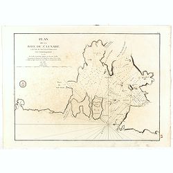
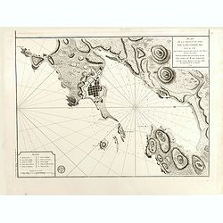
Plan du Bassin et de la Riviere du Port Royal ou Annapolis, dans l'Acadie sur la Cote Orientale de la Baie Francois . . .
Revolutionary war sea the Bay of Annapolis Royal, a small Canadian town located in the western part of Annapolis County, Nova Scotia, and was known as Port Royal until t...
Date: Paris, 1778
Selling price: ????
Please login to see price!
Sold in 2016
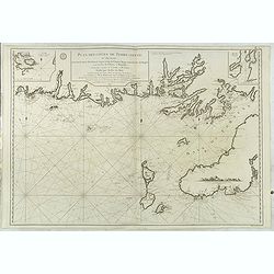
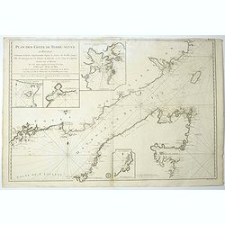
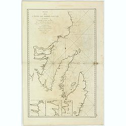
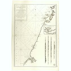
Plan des Côtes de Terre-Neuve, II ème Feuille..
Fine 1784 sea . of the southwest coast of Newfoundland, Canada, issued by the Depot de la Marine and surveyed by Captain Cook. This map, the second in this series. The F...
Date: Paris, 1778
Selling price: ????
Please login to see price!
Sold in 2016
![[Grand Bay of Pasamaquody, St. Croi.x River, Etang Harbour, Beaver Harbour, etc]](/uploads/cache/36361-250x250.jpg)
[Grand Bay of Pasamaquody, St. Croi.x River, Etang Harbour, Beaver Harbour, etc]
This superb
Date: London, ca.1778
Selling price: ????
Please login to see price!
Sold in 2015
![[Coast of Maine showing Blue Hill Bay, Penobscot Bay, Belfast Bay, Islesboro Island, Deer Island, and other islands.]](/uploads/cache/36362-250x250.jpg)
[Coast of Maine showing Blue Hill Bay, Penobscot Bay, Belfast Bay, Islesboro Island, Deer Island, and other islands.]
A chart of coast of Maine showing Blue Hill Bay, Penobscot Bay, Belfast Bay, Islesboro Island, Deer Island, and other islands taken from the "Atlantic Neptune",...
Date: London, 1778
Selling price: ????
Please login to see price!
Sold in 2015
![[Mount Desert Island and neighboring coast of Maine. ]](/uploads/cache/36363-250x250.jpg)
[Mount Desert Island and neighboring coast of Maine. ]
This superb sea chart constructed for the use of the British Navy showschart of coast of Hancock County, with Mount Desert Island and neighboring coast of Maine, taken fr...
Date: London, 1778
Selling price: ????
Please login to see price!
Sold in 2015
![[Coast of Maine showing Blue Hill Bay, Penobscot Bay, Belfast Bay, Islesboro Island, Deer Island, and other islands.]](/uploads/cache/36483-250x250.jpg)
[Coast of Maine showing Blue Hill Bay, Penobscot Bay, Belfast Bay, Islesboro Island, Deer Island, and other islands.]
A chart of coast of Maine showing Casco Bay taken from the "Atlantic Neptune", no date.Henry Stevens identified six states of the chart. This superb
Date: London, ca. 1778
Selling price: ????
Please login to see price!
Sold in 2015
![[The south east coast of Cape Breton Island]](/uploads/cache/36484-250x250.jpg)
[The south east coast of Cape Breton Island]
A chart of part of Canada taken from the "Atlantic Neptune", and marked in lower right corner "Published according to Act of Parliament Jan. The 20th 1778 ...
Date: London, 1778
Selling price: ????
Please login to see price!
Sold in 2016
![[A chart of the N.E.Coast of Cape Breton Island]](/uploads/cache/36485-250x250.jpg)
[A chart of the N.E.Coast of Cape Breton Island]
A chart of part of Canada taken from the "Atlantic Neptune", and marked in lower right corner "Published according to Act of Parliament Jan. The 20th 1778 ...
Date: London, 1778
Selling price: ????
Please login to see price!
Sold in 2015
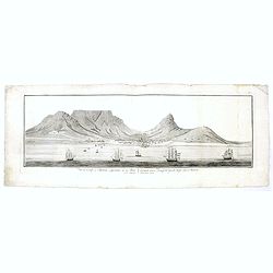
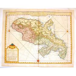
Vue du Cap de Bonne esperance de la baie / Gezigt van de Kaap der Goede hope van de reede.
A large rare panoramic view of Cape of Good Hope seen from the sea side with Dutch vessels in the foreground and Tafe-berg and the town in good detail. The fortress to th...
Date: Amsterdam, 1778
Selling price: ????
Please login to see price!
Sold in 2017
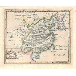
China.
Prepared by Thomas Jefferys and Thomas Phinn for Salmon's New Universal Geographical Grammar.
Date: Edinburgh, 1778
Selling price: ????
Please login to see price!
Sold in 2018
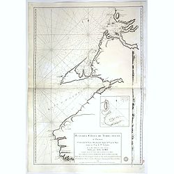
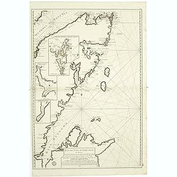
Plan des Côtes de Terre-Neuve, IV ème Feuille..
Revolutionary war sea .Relief shown by hachures. Depths shown by soundings. Below engraved seal of Depot General de la Marine. Prepared under the direction of de Maréch...
Date: Paris, 1778
Selling price: ????
Please login to see price!
Sold in 2017
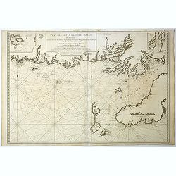
Plan des Côtes de Terre-Neuve, VI ème Feuille. . .
Revolutionary war sea of the Strait of Belle Isle (Beautiful Island) which is a waterway in eastern Canada that separates the Labrador Peninsula from the island of Newfo...
Date: Paris, 1778
Selling price: ????
Please login to see price!
Sold in 2017
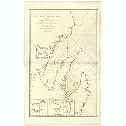
Plan des Côtes de Terre-Neuve, II ème Feuille. . .
Fine 1784 sea of the southwest coast of Newfoundland, Canada, issued by the Depot de la Marine and surveyed by Captain Cook. This map, the second in this series. The Fre...
Date: Paris, 1778
Selling price: ????
Please login to see price!
Sold in 2017
![[Untitled chart of the Long Island Sound including Block Island]](/uploads/cache/39179-250x250.jpg)
[Untitled chart of the Long Island Sound including Block Island]
A chart of the end of Long Island and the area around Gardiner’s Bay. Including Gardners Island, and Block Island. Gardiner’s Island was used as a base by the British...
Date: London, 1778
Selling price: ????
Please login to see price!
Sold in 2017
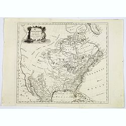
North America agreeable to the most approved maps and charts. . .
A detailed and uncommon map of North America with the Northwest labeled These Parts Are Entirely Unknown and the notations on the West Coast make various explorers' findi...
Date: London, 1778
Selling price: ????
Please login to see price!
Sold in 2017
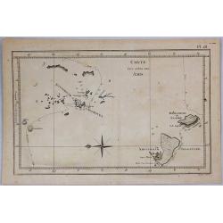
Carte des Isles des Amis.
This engraved chart depicts the Kingdom of Tonga, also known as the 'Friendly Islands', and one of the last hereditary monarchies. Cook discovered and named this group th...
Date: London, 1778
Selling price: ????
Please login to see price!
Sold in 2019
Le Colonie Unite dell´America.
Title: 'La Colonie Unite Dell' America Settentrle.' An impressive twelve-sheet map. This is Antonio Zatta's version of John Mitchell's landmark map, with some additional ...
Date: Italy, 1778
Selling price: ????
Please login to see price!
Sold in 2017
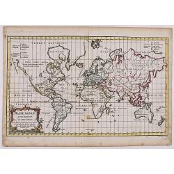
Mappe Monde suivant la projection des cartes reduites.
Original antique copperplate-engraved 1778 map by Robert de Vaugondy on Mercator's Projection, with original outline color showing the areas associated with the four majo...
Date: Paris, 1778
Selling price: ????
Please login to see price!
Sold in 2019
Carte du cours du fleuve de Saint Laurent depuis la Mer jusqu a Quebec. . .
Revolutionary war sea of the St Lawrence river at its estuary . With 4 insets and a large title cartouche.Relief shown by hachures. Depths shown by soundings. Below engr...
Date: Paris, 1778
Selling price: ????
Please login to see price!
Sold in 2018
Plan de la baie de Saint-Lunaire, à la côte nord-est de Terre-Neuve. . .
Revolutionary war sea of the bay de Saint-Lunaire, in New Foundland, Canada.Relief shown by hachures. Depths shown by soundings. Below engraved seal of Depot General de ...
Date: Paris, 1778
Selling price: ????
Please login to see price!
Sold in 2018
Plan des Côtes de Terre-Neuve: IXe Feuille..
Revolutionary war sea .Relief shown by hachures. Depths shown by soundings. Below engraved seal of Depot General de la Marine. Prepared under the direction of de Maréch...
Date: Paris, 1778
Selling price: ????
Please login to see price!
Sold in 2018
Carte Hydrographique de la Baye de Cadix.
Sea of the Bay of Cadix .Relief shown by hachures. Depths shown by soundings. Below engraved seal of Depot General de la Marine. Prepared under the direction of Duc de C...
Date: Paris, 1778
Selling price: ????
Please login to see price!
Sold in 2018
Plan des Côtes de Terre-Neuve: IXe Feuille..
Revolutionary war sea .Relief shown by hachures. Depths shown by soundings. Below engraved seal of Depot General de la Marine. Prepared under the direction of de Maréch...
Date: Paris, 1778
Selling price: ????
Please login to see price!
Sold in 2018
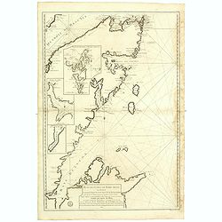
Plan des Côtes de Terre-Neuve, VII ème Feuille..
Revolutionary war sea of New Foundland.Relief shown by hachures. Depths shown by soundings. Below engraved seal of Depot General de la Marine. Prepared under the directi...
Date: Paris, 1778
Selling price: ????
Please login to see price!
Sold in 2018
Plan des Côtes de Terre-Neuve, VII ème Feuille..
Revolutionary war sea of New Foundland .Relief shown by hachures. Depths shown by soundings. Below engraved seal of Depot General de la Marine. Prepared under the direct...
Date: Paris, 1778
Selling price: ????
Please login to see price!
Sold in 2018
Plan des Côtes de Terre-Neuve, V ème Feuille..
Revolutionary war sea of New Foundland.Relief shown by hachures. Depths shown by soundings. Below engraved seal of Depot General de la Marine. Prepared under the directi...
Date: Paris, 1778
Selling price: ????
Please login to see price!
Sold in 2018
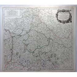
Le Cercle de Baviere. . .
A pleasant Bavarian map showing the area north (to Bayreuth) and south (to Kitzbühel) of the Danube between Dillingen in the west and Grein in the east. Decorative title...
Date: Paris, 1778
Selling price: ????
Please login to see price!
Sold in 2019

Christopher Columbus & the Discovery of America.
[Two Engraved Prints] A pair of historical copper engravings, including a portrait of Christopher Columbus, and another with Columbus’ landfall in the New World. He str...
Date: London, 1778
Selling price: ????
Please login to see price!
Sold in 2018

Pizarro, De Valdibia, De Alvarado, De la Gasca, Cortez & De Almagro.
Six historical copper engravings featuring portraits of men who discovered different parts of America including:Francisco Pizarro (1496 - 1541) Led an Expedition that con...
Date: London, 1778
Selling price: ????
Please login to see price!
Sold in 2019
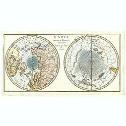
Carte des Deux Regions Polaires Jusqu'au 45.e Degre de Latitude.
Interesting map of the poles showing numerous tracks of explorers, including Tasman, Furneaux, Halley, Marion, and the 1773 expedition of Cook. There is an unusual and ut...
Date: Paris, 1778
Selling price: ????
Please login to see price!
Sold in 2018
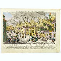
Representation du feu terrible à Nouvelle York.
So-called optical print of New York, showing several buildings along street engulfed in flames during fire on September 19, 1776, citizens being beaten by Redcoats, and l...
Date: Augsburg, 1778
Selling price: ????
Please login to see price!
Sold in 2019
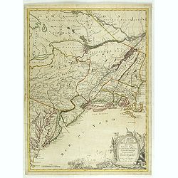
Carte du Theatre de la Guerre actuel entre les Anglais et les Trieze Colonies Unies de l'Amerique Septentrionale dresse par J.B. Eliot
A fine example of J. B. Eliot's map of the United States, in its first state of which is generally regarded as the earliest map to include the title "United States''...
Date: Paris, 1778
Selling price: ????
Please login to see price!
Sold
![The country Coromandel from the Coleroon to Cape Comorin. . . [with] The carnatic from the Pennar to the Coleroon. .](/uploads/cache/40457-250x250.jpg)
The country Coromandel from the Coleroon to Cape Comorin. . . [with] The carnatic from the Pennar to the Coleroon. .
Coromandel from the Coleroon to Cape Comorin. Elegant map in two sheets compiled for the East-India Company. In lower right margin : Writing by W. Harrison.
Date: London, 1778
Selling price: ????
Please login to see price!
Sold in 2020
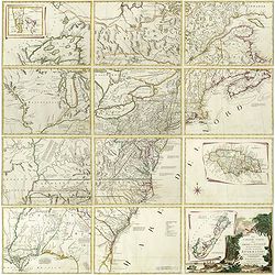
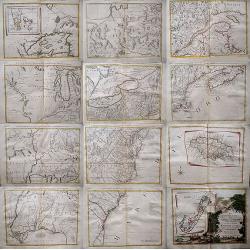
Le Colonie Unite dell America Settentr.le di Nouva Projezione . . .
A complete set of 12 maps that when joined together form a large map of North America. Shows North America west to the Mississippi and Spanish-owned Louisiana, and north ...
Date: Venise, 1778
Selling price: ????
Please login to see price!
Sold in 2019

Le Colonie Unite dell America Settentr. le di Nouva Projezione . . .
A complete set of 12 maps that when joined together form a large map of North America. Shows North America west to the Mississippi and Spanish-owned Louisiana, and north ...
Date: Venise, 1778
Selling price: ????
Please login to see price!
Sold in 2019
La Baja D' HUDSON Terra Di Labrador e Groenlandia con Le Isole Adiacenti.
An excellent, old outlined colored map of Hudson Bay, Baffin Bay, part of Greenland, Labrador and Northern Canada. With marvellous detail on the islands and coastlines, k...
Date: Venice, 1778
Selling price: ????
Please login to see price!
Sold in 2020
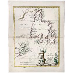
Le Isole di TERRA NUOVA e CAPO BRETON Di Nuova Projezione.
A gorgeous separate map of Newfoundland and Cape Breton Island, along with neighbouring Islands, including St. Pierre Michelon. An old outlined colored map with a cartouc...
Date: Venice, 1778
Selling price: ????
Please login to see price!
Sold in 2019
![[Map of the interior of North America and New Spain] (sheet: No.2)](/uploads/cache/82993-250x250.jpg)
[Map of the interior of North America and New Spain] (sheet: No.2)
An engraved, old colored map showing roads, wooded areas, swamps, and settlements; areas of Native American habitation and the route of the Spanish Galleons. Includes not...
Date: Vienna, 1778
Selling price: ????
Please login to see price!
Sold in 2019
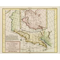
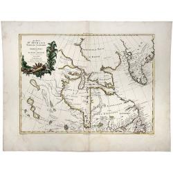
Carte de la Californie et des Pays Nord-Ouest. . .
Diderot's famous 2 on 1 map showing the two early mappings of the west coast of North America, the first after Visscher, the second after Plancius' World map. Both show t...
Date: Paris, 1779
Selling price: ????
Please login to see price!
Sold in 2019

Carte des provinces-unies connue sous le nom d'Hollande dressée sur les nouvelles observations ordonnée par les etats généraux par J. B. de la Fosse. . . 1779
Rare map of the Netherlands prepared by Jean-Baptiste Delafosse. North Sea is filled with ships. Louis Joseph Mondhare was active in Paris and published several smaller a...
Date: Paris, 1779
Selling price: ????
Please login to see price!
Sold in 2012
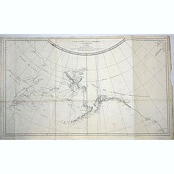
Carte de la côte N. O. de l\'Amérique et de la côte N. E. de l\'Asie reconnues en 1778 et 1779..
Map of the north Pacific with Alaska, engraved by Bernard.
Date: Paris, c. 1779
Selling price: ????
Please login to see price!
Sold in 2013
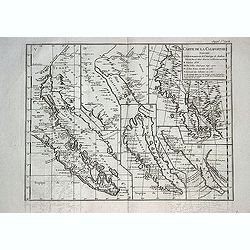
Carte de la Californie suivant. . . (Five maps on one sheet)
Five maps on one folding sheet, showing the development of the mapping of California. The map is from Diderot's Encyclopedie which contains ten maps of America, Asia and ...
Date: Paris, 1779
Selling price: ????
Please login to see price!
Sold in 2013
![A map of the Kingdom of Ireland showing the archbishopricks, bishopricks, cities, boroughs, market towns, villages, barracks, mountains [. . .] by J. Rocque, chorographer to His Majesty.](/uploads/cache/92786-250x250.jpg)
A map of the Kingdom of Ireland showing the archbishopricks, bishopricks, cities, boroughs, market towns, villages, barracks, mountains [. . .] by J. Rocque, chorographer to His Majesty.
A dramatic large four sheet map, (here on two joined sheets) from Sayer's large Atlas of 1779.Rocque was Topographer to the Prince of Wales and attained his new title aft...
Date: London, 1779
Selling price: ????
Please login to see price!
Sold in 2015
Carte de L\'Isle de la Martinique.
Fine copper engraved map of the Island of Martinique in the Caribbean. It is detailed with lakes, rivers, cities, towns, mountains and forests. Nice block-style cartouche...
Date: Paris, 1779
Selling price: ????
Please login to see price!
Sold in 2014
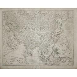
Carte d'Asie.
This is Guillaume de l’Isles third map of the continent of Asia, showing the improvements in knowledge made during the first quarter of the 18th century. Arabia has bee...
Date: Paris 1779
Selling price: ????
Please login to see price!
Sold in 2013
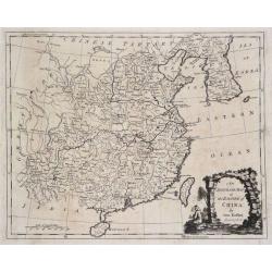
An Accurate Map of the Empire of China.
A highly detailed map of China and Korea including both Hainan and Formosa (Taiwan). An ornate scenic title cartouche completes the composition. The maps border shows the...
Date: London, 1779
Selling price: ????
Please login to see price!
Sold in 2015
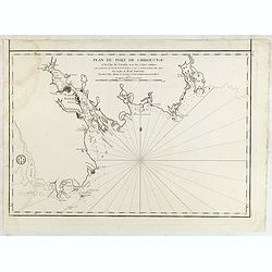
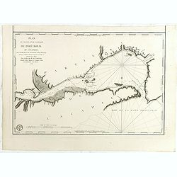
Plan du port de Chibouctou à la cote de l'Acadie avec les cotes voisines. . .
French chart of the vicinity of Halifax Harbor from Chebucto Head to the head of Bedford Basin.Issued in Neptune americo-septentrionale by "Depot Général de la Mar...
Date: Paris, 1779
Selling price: ????
Please login to see price!
Sold in 2015
Plan du Port et Ville de Louisbourg levé en 1756...
French chartof Louisbourg in 1756.Made under the direction of M. de Sartine. Relief shown by hachures. Depths shown by soundings. Below title, engraved seal of Depot Gene...
Date: Paris, 1779
Selling price: ????
Please login to see price!
Sold in 2015
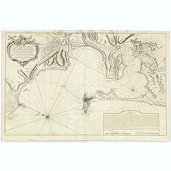
Plan du Bassin et de la Riviere du Port Royal ou Annapolis, dans l'Acadie sur la Cote Orientale de la Baie Francois . . .
French chartof the Bay of Annapolis Royal, a small Canadian town located in the western part of Annapolis County, Nova Scotia, and was known as Port Royal until the Conqu...
Date: Paris, 1779
Selling price: ????
Please login to see price!
Sold in 2018
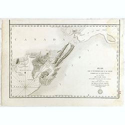
Plan de l'isthme de l'Acadie comprenant le Beau-Bassin avec une partie de la Baie Verte...
French chart of the Isthmus of Chignecto, an isthmus bordering the Maritime provinces of New Brunswick and Nova Scotia, Canada. Made under the direction of M. de Sartine....
Date: Paris, ca.1779
Selling price: ????
Please login to see price!
Sold in 2017
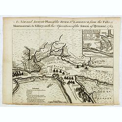
New and Accurate Plan of the River St. Lawrence, from the Falls of Montmorenci to Sillery, with the Operations of the Siege of Quebec 1763
Plan of the siege of Quebec, published in Published in: "The General History of the Late War", first published in 1766, and also in 1775 and 1779 and in "T...
Date: London / Manchester, 1762 - 1779
Selling price: ????
Please login to see price!
Sold in 2016
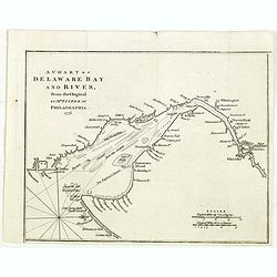
A chart of Delaware Bay and River : from the original by Mr. Fisher of Philadelphia 1776
Taken from the important chart of Delaware Bay and River up to Philadelphia by Joshua Fisher in 1776. Kashnor notes, "Shows the river from Cape James to Philadelphia...
Date: London, July 1779
Selling price: ????
Please login to see price!
Sold in 2021
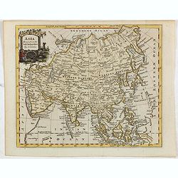
Asia drawn from the best authorities by T. Kitchin.
Map of Asia from William Guthrie, "A new geographical, historical, and commercial grammar... with a correct set of maps, engraved by Mr. Kitchin... The sixth edition...
Date: London, 1779
Selling price: ????
Please login to see price!
Sold in 2015
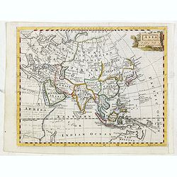
Asia T. Jefferys sculp
Map of Asia from William Guthrie, "The modern gazetteer: or, A short view of the several nations of the world. Absolutely necessary for rendering the public news, an...
Date: London, 1779
Selling price: ????
Please login to see price!
Sold in 2015
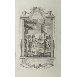
Sir Walter Raleigh ordering the standard of Queen Elizabeth to be erected on the coast of Virginia.
A very decorative historical scene of Sir Walter Raleigh ordering the standard of Queen Elizabeth to be erected on the coast of Virginia in 1584, engraved by Taylor for '...
Date: London, 1779
Selling price: ????
Please login to see price!
Sold in 2015
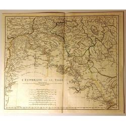
L'Euphrate et le Tigre
Detailed map of present day Syria and Iraq. It shows adjacent lands of Anatolia, and Iran. Some of the names of provinces and tribes are: Alghezira, Kurdistan, Chuzestan,...
Date: Paris, 1779
Selling price: ????
Please login to see price!
Sold in 2020

(Title page) Atlas Portatif a L 'Usage des Colleges.
An attractive frontispiece of Rigobert Bonne's “Atlas Portatif a L 'Usage des Colleges”. The titlepage seems to encapsulate the spirit of the "Age of Enlightenme...
Date: Paris, 1779
Selling price: ????
Please login to see price!
Sold in 2019
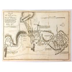
Plan of St. Lucia in the West Indies
A detailed plan by Thomas Bowen of the battle between the English and French forces in St. Lucia during the Revolutionary War. It illustrates the various attacks, and cou...
Date: London, 1779
Selling price: ????
Please login to see price!
Sold in 2016
Plan de la Baie et du Havre de Casco et des Iles Adjacents. . .
Sea chart of Casco Bay in Maine. Published in "Neptune Americo-Septentrional" at the time of the American Revolution. According to the title prepared by Antoine...
Date: Paris, ca.1779
Selling price: ????
Please login to see price!
Sold in 2018
Plan du Port Dauphin, de la rade de St.Anne, de l'entrée de Labrador et de la Baie de Niganiche. . .
Sea chart of the rade of St.Anne. Published in "Neptune Americo-Septentrional" at the time of the American Revolution. According to the title prepared by Antoin...
Date: Paris, ca.1779
Selling price: ????
Please login to see price!
Sold in 2018
Plan de la baie de Gabarus située a la côte S.E. de l'Île Royale. . .
Sea chart of Gabarus Bay. Published in "Neptune Americo-Septentrional" at the time of the American Revolution. According to the title prepared by Antoine Sartin...
Date: Paris, ca.1779
Selling price: ????
Please login to see price!
Sold in 2018
![Plan du Port De La Riviere St. Jean Situe a la Cote Septentrionale De La Baie Francoise de L'Acadie. . . [with] Plan du port e la Heve . . . and Plan du port Rochelois. . .](/uploads/cache/39162-250x250.jpg)
Plan du Port De La Riviere St. Jean Situe a la Cote Septentrionale De La Baie Francoise de L'Acadie. . . [with] Plan du port e la Heve . . . and Plan du port Rochelois. . .
Early chart of the Saint John River and St. John together with "Plan du port e la Heve . . ." and "Plan du port Rochelois. . ." Published in "Nep...
Date: Paris, ca.1779
Selling price: ????
Please login to see price!
Sold in 2018
![Plan du Port De La Riviere St. Jean Situe a la Cote Septentrionale De La Baie Francoise de L'Acadie. . . [with] Plan du port e la Heve . . . and Plan du port Rochelois. . .](/uploads/cache/39163-250x250.jpg)
Plan du Port De La Riviere St. Jean Situe a la Cote Septentrionale De La Baie Francoise de L'Acadie. . . [with] Plan du port e la Heve . . . and Plan du port Rochelois. . .
Early chart of the Saint John River and St. John together with "Plan du port e la Heve . . ." and "Plan du port Rochelois. . ." Published in "Nep...
Date: Paris, ca.1779
Selling price: ????
Please login to see price!
Sold in 2018

