Browse Listings
![Plan de la baie de Nérichac, à la côte du sud de l'Île Madame. . . [with] Plan du port Toulouse, à la cote du sud de l'isle Royale. . .](/uploads/cache/39164-250x250.jpg)
Plan de la baie de Nérichac, à la côte du sud de l'Île Madame. . . [with] Plan du port Toulouse, à la cote du sud de l'isle Royale. . .
Early charts of Nerichac Bay on the south coast of Isle Madame together with chart of Port Toulouse on the south coast of Isle Royale. Published in "Neptune Americo-...
Date: Paris, ca.1779
Selling price: ????
Please login to see price!
Sold in 2018
![[Untitled chart of Portland and Falmouth in Maine]](/uploads/cache/39181-250x250.jpg)
[Untitled chart of Portland and Falmouth in Maine]
Fine chart of Portland and Falmouth in Maine, showing the homesteads, roads, and topography in the vicinity of Portland to the lower left corner. Taken from the "Atl...
Date: London, 1779
Selling price: ????
Please login to see price!
Sold in 2017
![[Untitled chart of Coast of Maine showing Blue Hill Bay, Penobscot Bay, Belfast Bay, Islesboro Island, Deer Island, and other islands]](/uploads/cache/39182-250x250.jpg)
[Untitled chart of Coast of Maine showing Blue Hill Bay, Penobscot Bay, Belfast Bay, Islesboro Island, Deer Island, and other islands]
Fine chart of coast of Maine showing Blue Hill Bay, Penobscot Bay, Belfast Bay, Islesboro Island, Deer Island, and other islands Taken from the "Atlantic Neptune&quo...
Date: London, 1779
Selling price: ????
Please login to see price!
Sold in 2017
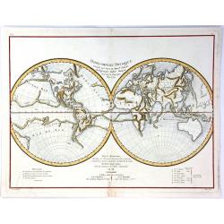
Mappe-Monde Physique d'Apres les Vues du Profr. Pallas Redigees par Andre Mongez
An unusual map of the world with physical topography that reveals mountain ranges both on land and under the sea.The curious undersea mountain ranges displayed here were ...
Date: Paris, 1779
Selling price: ????
Please login to see price!
Sold in 2018
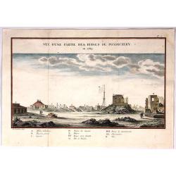
Vue D'Une Partie des Ruines de Pondichery en 1769.
Fine city view of Pondicherry India by Guillaume le Gentil. It was engraved by Gardette in 1769. It has a key at the bottom identifying important buildings in the city.
Date: Paris , 1779
Selling price: ????
Please login to see price!
Sold in 2018
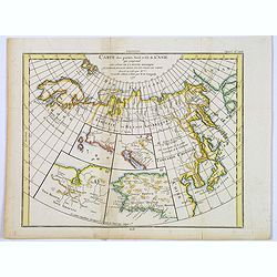
Carte des parties Nord et Est de L'Asie. . .
Five maps on one sheet, showing the Northern Russian territories in Europe and Asia, including the western coastline from Siberia, with Japan and Korea with the island of...
Date: Paris, 1779
Selling price: ????
Please login to see price!
Sold in 2017
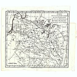
Carte de la Lithuanie, de la Courlande, et de la nouvelle Russie Blanche démembrée de la Pologne.
A map of the Lithuania territories of Louis Brion de la Tour, from the work "Histoire universelle depuis le commencement du monde jusqu a present" published in ...
Date: Paris, 1779
Selling price: ????
Please login to see price!
Sold in 2019
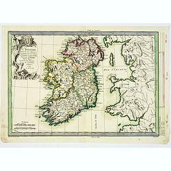
L'Irlande. . .
An attractive map of Ireland, prepared by M. Philippe, embellished with a decorative title cartouche. Drawn and engraved by Vallet and Moithey. With a scale of miles, and...
Date: Paris, 1779
Selling price: ????
Please login to see price!
Sold in 2018
Le Voyageur François, ou la Connoissance de l'Ancien et du Nouveau Monde. Tome XXII.
With folding map of Poland (180 x 220mm.)
Date: Paris, L.Cellot, 1779
Selling price: ????
Please login to see price!
Sold in 2019
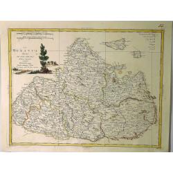
La Moravia Divisa Ne Suoi Circoli. . .
A handsome map of Moravia that is part of the present-day Czech Republic. The map is focused roughly on Wischau and is filled with details of roads, towns and pictorial t...
Date: Venice, 1779
Selling price: ????
Please login to see price!
Sold in 2021
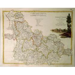
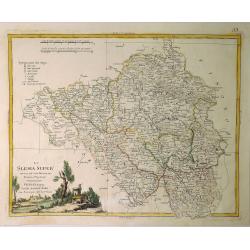
La Slesia InferE Divisa ne Principati di Nuova Projezione.
A handsome map of South Western Poland divided into its provinces. Filled with details of roads, towns and pictorial topography, and features a lovely pastoral title cart...
Date: Venice, 1779
Selling price: ????
Please login to see price!
Sold in 2020
La Slesia Super Divisa ne Suoi Principati di Nuova Projezione.
A striking map of Upper Silesia divided into its principalities. This is now South-Eastern Poland. Features pleasing topographical title cartouche. Antonio Zatta (1757–...
Date: Venice, 1779
Selling price: ????
Please login to see price!
Sold in 2019
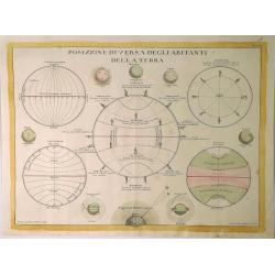
Posizione Diversa Deglia Abitanti Della Terra.
This decorative print explains the different regions of the earth, divided by lines of longitude and latitude, and into its tropical, temperate and polar regions. From Za...
Date: Venice, 1779
Selling price: ????
Please login to see price!
Sold in 2023
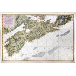
![[Untitled] Sea chart of Ceylon and Southern India.](/uploads/cache/44286-250x250.jpg)
[Untitled] Sea chart of Ceylon and Southern India.
A scarce separately published English Sea Chart of the south coast of India, the island of Ceylon, with inset maps of Gula Bay (Galle) Sri Lanka, Tutocarine Bay (Tuticori...
Date: London, 1779
Selling price: ????
Please login to see price!
Sold in 2019
Carte Reduite de L'Acadie ou Nouvelle Ecosse. Comprenant une partie de l'ile Royale de l'ile St. Jean et du Canada.
A map of Acadia or Nova Scotia comprising part of Cape Breton, St. John Island and Canada written at the General Depot of Maps, Plans and Marine Journals by order of Mr. ...
Date: Paris, 1779
Selling price: ????
Please login to see price!
Sold in 2020
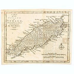
A Map of the Island of Tobago, drawn from an Actual Survey.
An nice, small map delightfully engraved with good detail. The island is sectioned off into seven distinct divisions, each identifying the number of acres and estates. Ne...
Date: London, 1779
Selling price: ????
Please login to see price!
Sold in 2020
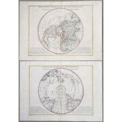
Emisfero terrestre Meridionale Tagliato Su l'Equatore & Emisfero terrestre Settentrionale Tagliato su l'equatore.
Pair of Polar Projections of the Northern & Southern Hemisphere. From: Antonio Zatta, 'Atlante Novissimo, illustrato ed accresciuto sulle osservazioni, e scoperte fat...
Date: Venice, 1779
Selling price: ????
Please login to see price!
Sold in 2022
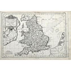
L'Angleterre... par Mr. Philippe. . .
An unusual copper engraved map of England, also showing parts of Ireland. Filled with places names in England. Decorative title cartouche. With a curious climatalogical s...
Date: Paris, 1779
Selling price: ????
Please login to see price!
Sold in 2020
![Carte Des Nouvelles Decouvertes dresseee par Phil. Buache... [with] Extrait d'une Carte Japonoise de l'Univers apportee en Europe par Kaempfer . . . [Bay of the West]](/uploads/cache/46319-250x250.jpg)
Carte Des Nouvelles Decouvertes dresseee par Phil. Buache... [with] Extrait d'une Carte Japonoise de l'Univers apportee en Europe par Kaempfer . . . [Bay of the West]
A very interesting pair of rare maps published as a single sheet in the 10 part series of maps created by Robert de Vaugondy in his 'supplement Receuil de 10 cartes trait...
Date: Paris, 1779
Selling price: ????
Please login to see price!
Sold in 2020
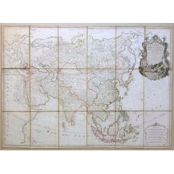
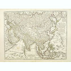
Carte de l'Asie divisée en ses principaux etats, projettée et assujettie au ciel par M. Bonne, Hydrographe du Roi.
A very rare and large 18th century map of the Asian continent. This map can only be found in a few institutional collections. An impressive and artistic cartouche.
Date: Paris, 1779
Selling price: ????
Please login to see price!
Sold in 2020
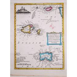
Antique map of the Channel Islands.
A nice antique map of the Channel Islands, published in the English Gentleman's Magazine. Inset at top left of Cornet Castle. Mileage scale.
Date: London, 1779
Selling price: ????
Please login to see price!
Sold in 2020

Globe Terrestre / Globe Celeste.
An attractive and inexpensive late eighteenth century copperplate engraving showing a terrestrial and celestial globe on their fine rings and bases, as engraved for Middl...
Date: London 1779
Selling price: ????
Please login to see price!
Sold in 2020
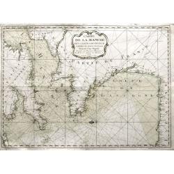
Carte de la Manche des costes de France parties de celle d'Espagne jusqu'au Cap Orgetal.
A very rare sea-chart of the Channel between England and France, including the Bay of Biscay with the coasts of northern Spain, and even a small tip of Ireland. A very ap...
Date: Bordeaux, 1779
Selling price: ????
Please login to see price!
Sold in 2021
Carte d'Asie. . .
Detailed map of Asia with an inset map of Siberia and the east coast of America with a "Nord-Ouest" passage.The map is of interest for the use of East Sea, the ...
Date: Paris, 1779
Selling price: ????
Please login to see price!
Sold

Chirurgie, plate XXIV
Showing a eye-surgeon at work from the medical section of Diderot's Encyclopaedia. Engraved by Bernard after a design of Goussier. Very important work as it is giving an ...
Date: Paris 1779
Selling price: ????
Please login to see price!
Sold in 2015
Marché Désclaves Pl.XI. / Coton / Ventilateur et Mache.
Plates from the small edition of Diderot's Encyclopaedia. Engraved by Laurent. Very important work as it is giving an inventory of the science and craftsmanship of the 18...
Date: Paris 1779
Selling price: ????
Please login to see price!
Sold
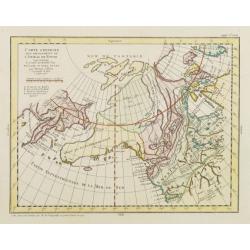
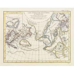
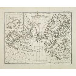
Carte Générale des Découvertes de l'Amiral de Fonte representant la grande probabilité d'un Passage au Nord Ouest. . .
Robert de Vaugondy based this map of the northern Pacific and Alaska on a publication by Thomas Jefferys in London in 1768. Published in the supplement to Diderot’s &qu...
Date: Paris, 1779
Selling price: ????
Please login to see price!
Sold in 2013
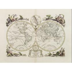
Il Mappamondo o sia Descrizione Generale del Globo.
Double-hemisphere world, with allegorical figures of the Four Continents in the corners. Published just after the news of Cook's first circumnavigation was published, his...
Date: Venice 1779
Selling price: ????
Please login to see price!
Sold
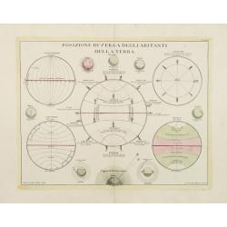
Posizione diversa degliabitanti della terra.
Attractive Italian illustration describing 5 astronomical spheres and a compass rose. From ?Atlante Novissimo.? Attractive and finely engraved.
Date: Venice 1779
Selling price: ????
Please login to see price!
Sold
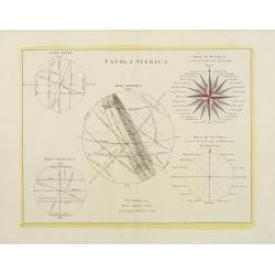
Tavola Sferica.
Attractive Italian astronomical chart with 5 spheres showing Latitudes and Longitudes, with 8 smaller spheres depicting the Sun, Moon, Mercury, Mars & Venus. From &qu...
Date: Venice, 1779
Selling price: ????
Please login to see price!
Sold in 2013
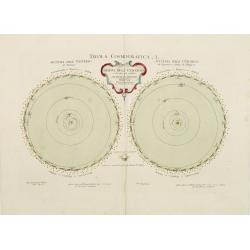
Tavola Cosmografica .I. Mappa dell' Universo e de due pui celebri sistemi planetarj..
Double-hemispheres, celestial projections from the northern and southern hemispheres. Drawn by Castellan, embellished by Pittori and engraved by Zuliani. Blank on verso.F...
Date: Venice 1779
Selling price: ????
Please login to see price!
Sold
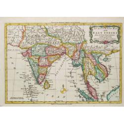
An Accurate Map of the East Indies.
A detailed map of India and Indo China from Middleton's "Complete System of Geography".
Date: London, 1779
Selling price: ????
Please login to see price!
Sold
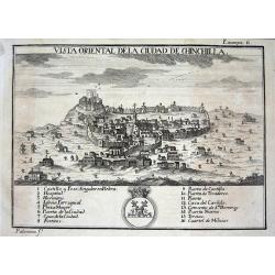
Vista oriental de la ciudad de Chinchilla.
Scarce city view from "ATLANTE ESPAÑOL - Don Bernardo Espinalt y Garcia" engraved by Palomino, showing Chinchilla de Monte Aragón in Albacete. Numerous buildi...
Date: Madrid, 1779
Selling price: ????
Please login to see price!
Sold
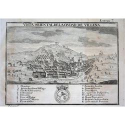
Vista oriental de la ciudad de Villena.
Scarce city view from "ATLANTE ESPAÑOL - Don Bernardo Espinalt y Garcia" engraved by Palomino, showing Villena, a strategic important city close to Alicante. N...
Date: Madrid 1779
Selling price: ????
Please login to see price!
Sold in 2008

Vista septentrional de la ciudad de Tervel.
Scarce city view from "ATLANTE ESPAÑOL - Don Bernardo Espinalt y Garcia" engraved by Palomino, showing Tervel and its strong city walls. Numerous buildings are...
Date: Madrid, 1779
Selling price: ????
Please login to see price!
Sold
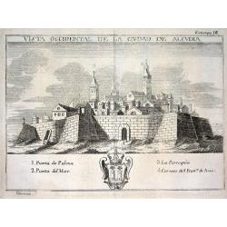
Vista occidental de la ciudad de Alcudia.
Scarce city view from "ATLANTE ESPAÑOL - Don Bernardo Espinalt y Garcia" engraved by Palomino, showing Alcudia, a town in the northern part of the Balearic Isl...
Date: Madrid, 1779
Selling price: ????
Please login to see price!
Sold
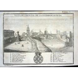
Vista occidental de la ciudad de Murcia
Scarce city view from "ATLANTE ESPAÑOL - Don Bernardo Espinalt y Garcia" engraved by Palomino, showing Murcia as seen from the East. Numerous buildings are nam...
Date: Madrid 1779
Selling price: ????
Please login to see price!
Sold
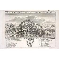
Vista meridional de la ciudad de Albarracin
Scarce city view from "ATLANTE ESPAÑOL - Don Bernardo Espinalt y Garcia" engraved by Palomino, showing Albarracin in Teruel, Aragon. Numerous buildings are nam...
Date: Madrid 1779
Selling price: ????
Please login to see price!
Sold
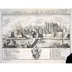
Vista meridional de la ciudad de Palma de Mallorca
Scarce city view from "ATLANTE ESPAÑOL - Don Bernardo Espinalt y Garcia" engraved by Palomino, showing Palma de Mallorca from its seaside including 3 sailing s...
Date: Madrid 1779
Selling price: ????
Please login to see price!
Sold

Mapa del Reyno de Murcia dividido en sus partidos
Scarce map of the area around Murcia from "ATLANTE ESPAÑOL - Don Bernardo Espinalt y Garcia" engraved by Palomino. Includes many placenames, a large title cart...
Date: Madrid 1779
Selling price: ????
Please login to see price!
Sold
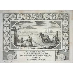
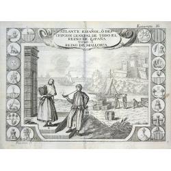
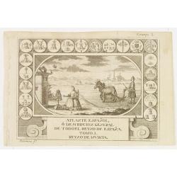
Atlante Espanol, ó descripcion general de todo el reyno de Espana.
Rare titlepage from "ATLANTE ESPAÑOL - Tomo.1. Reyno de Murcia" issued by Don Bernardo Espinalt y Garcia and engraved by Palomino. A rural scene with a farmer ...
Date: Madrid 1779
Selling price: ????
Please login to see price!
Sold
Atlante Espanol, ó descripcion general de todo el reyno de Espana
Rare titlepage from "ATLANTE ESPAÑOL - Tomo.3. Reino de Mallorca" issued by Don Bernardo Espinalt y Garcia and engraved by Palomino. Shows an harbour with sail...
Date: Madrid 1779
Selling price: ????
Please login to see price!
Sold

Chirurgie, plate V.
Showing instruments and sections of internal organs, from the medical section of Diderot's Encyclopaedia. Engraved by Bernard after a design of Goussier.Very important wo...
Date: Paris, 1779
Selling price: ????
Please login to see price!
Sold in 2010

Chirurgie, plate XXV.
Showing an eye-surgeon at work and various instruments, from the medical section of Diderot's "Encyclopaedia". Engraved by Bernard after a design of Goussier.Ve...
Date: Paris, 1779
Selling price: ????
Please login to see price!
Sold in 2013

Chirurgie, plate IX.
Showing medical instruments, from the medical section of Diderot's Encyclopaedia. Engraved by Bernard after a design of Goussier.Very important work as it is giving an in...
Date: Paris, 1779
Selling price: ????
Please login to see price!
Sold in 2016

Chirurgie, plate VII.
Showing medical tools and bondages, from the medical section of Diderot's Encyclopaedia. Engraved by Bernard after a design of Goussier.Very important work as it is givin...
Date: Paris, 1779
Selling price: ????
Please login to see price!
Sold in 2016

Chirurgie, plate XIII.
Showing male perineal anatomy section and physician at work from the medical section of Diderot\'s Encyclopaedia. Engraved by Bernard after a design of Goussier.Very impo...
Date: Paris, 1779
Selling price: ????
Please login to see price!
Sold in 2009

Chirurgie, plate XXVIII.
Showing female breast anatomy examples and medical tools, from the medical section of Diderot's Encyclopaedia. Engraved by Bernard after a design of Goussier.Very importa...
Date: Paris, 1779
Selling price: ????
Please login to see price!
Sold in 2016
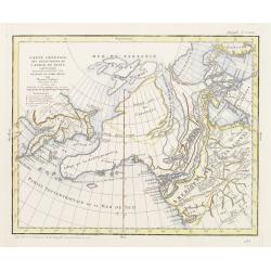
Carte générale des découvertes de l'Admiral de Fonte ..
Based on the map of the northern Pacific, published by Jacques-Nicolas de l'Isle in Paris in 1752. Shows clearly the extraordinary network of channels supposed to link th...
Date: Paris 1779
Selling price: ????
Please login to see price!
Sold
Carte générale des découvertes de l'Admiral de Fonte ..
Based on the map of the northern Pacific, published by Jacques-Nicolas de l'Isle in Paris in 1752. Shows clearly the extraordinary network of channels supposed to link th...
Date: Paris 1779
Selling price: ????
Please login to see price!
Sold
Carte de la Californie et des Pays Nord-Ouest..4de Carte
Diderot's famous 2 on 1 map showing the two early mappings of the west coast of North America, the first after Visscher, the second after Plancius' World map. Both show t...
Date: Paris, 1779
Selling price: ????
Please login to see price!
Sold in 2013
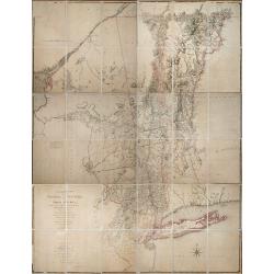
A Chorographical Map of the Province of New-York in North America, Divided into Counties, Manors, Patents and Townships ... January 1st. 1779.
CLAUDE JOSEPH SAUTHIER’S SUPERB MAP OF THE PROVINCE OF NEW YORK IS A TOUR-DE-FORCE. Sauthier (1736-1802) was an engineer who accompanied Governor William Tryon to North...
Date: London, January 1st. 1779
Selling price: ????
Please login to see price!
Sold in 2013
Atlante Espanol, ó descripcion general de todo el reyno de Espana. . .
Rare title page from \"ATLANTE ESPAÑOL - Tomo.1. Reyno de Murcia\" issued by Don Bernardo Espinalt y Garcia and engraved by Palomino. A rural scene with a farm...
Date: Madrid, 1779
Selling price: ????
Please login to see price!
Sold in 2010
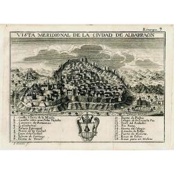
Vista meridional de la ciudad de Albarracin
Scarce and very decorative city view published in "ATLANTE ESPAÑOL - Don Bernardo Espinalt y Garcia" engraved by Palomino, showing Albarracin in Teruel, Aragon...
Date: Madrid, 1779
Selling price: ????
Please login to see price!
Sold in 2008
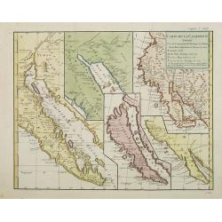
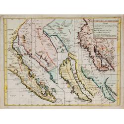
Carte de la Californie suivant..
Five maps on one folding sheet, showing the development of the mapping of California. The map is from Diderot's "Encyclopedie" which contains ten maps o...
Date: Paris, 1779
Selling price: ????
Please login to see price!
Sold in 2009
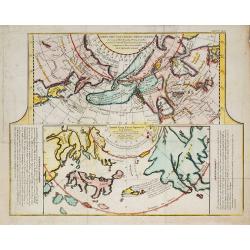
![Carte Des Nouvelles Decouvertes dresseee par Phil. Buache... [with] Extrait d'une Carte Japonoise de l'Univers apportee en Europe par Kaempfer . . . [Bay of the West]](/uploads/cache/25609-250x250.jpg)
Carte Des Nouvelles Decouvertes dresseee par Phil. Buache... [with] Extrait d'une Carte Japonoise de l'Univers apportee en Europe par Kaempfer . . . [Bay of the West]
This map is most notable for it's depiction of "Mer de L'Ouest" or "Sea of the West", a great sea, easily the size of the Mediterranean, to flow from ...
Date: Paris, 1779
Selling price: ????
Please login to see price!
Sold in 2014
Carte Générale des Découvertes de l'Amiral de Fonte, et autres . . .
A map from Diderot's Encyclopédie which makes the case for a northwest passage. Included as part of the evidence is the route of Admiral De Fonte, a completely fictitiou...
Date: Paris, (1752) 1779
Selling price: ????
Please login to see price!
Sold in 2011
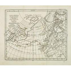
Carte générale des découvertes de l''Amiral de Fonte. . .
Based on the map of the northern Pacific, published by Jacques-Nicolas de l''Isle in Paris in 1752. It shows clearly the extraordinary network of channels supposed to lin...
Date: Paris, 1779
Selling price: ????
Please login to see price!
Sold in 2014
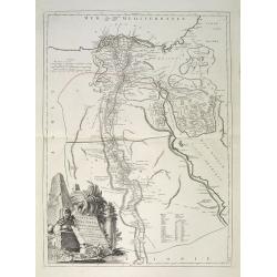
Carte de l'Egypte Ancienne et Moderne, dressee sur celle du R.P. Sicard et autres, assujetties aux observations astronomiques, par le Sr. Robert de Vaugondy
A splendid map of ancient Egypt, shows entire Nile valley in great detail. Large cartouche by Haussard shows ruins and a flirtatious sphinx.The map was prepared by the Ve...
Date: Venice, 1779
Selling price: ????
Please login to see price!
Sold in 2009
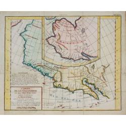
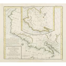
Carte de la Californie et des Pays Nord-Ouest ?
The map is from Diderot's Encyclopedie which contains ten maps of America, Asia and the Arctic Regions. This 2 on 1 map shows the two early mappings of the west coast of ...
Date: Paris, 1779
Selling price: ????
Please login to see price!
Sold in 2010
Carte de la Californie suivant . . .
Five maps on one folding sheet, showing the development of the mapping of California. The map is from Diderot's "Encyclopedie" which contains ten maps of Americ...
Date: Paris, 1779
Selling price: ????
Please login to see price!
Sold in 2009
Carte des Nouvelles découvertes ?
The map is from Diderot's 'Encyclopedia' which contains ten maps of Asia, America and the Arctic Regions. In both maps there are texts ago. by Kaempfer who refers to voya...
Date: Paris, 1779
Selling price: ????
Please login to see price!
Sold in 2009
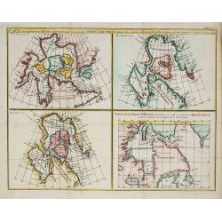
Carte qui représnte ? Terres Arctiques ... Suppl.Carte 9.
From Diderot's Encyclopaedia. Four maps on one sheet showing Hudson Bay according to Sanson's map of 1750 and De L'Isle 1700 and 1703. One map showing track of Henri Elli...
Date: Paris, 1779
Selling price: ????
Please login to see price!
Sold in 2010
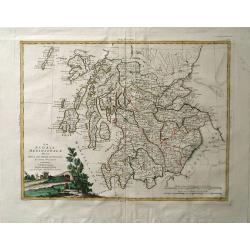
La Scozia Settentrionale Divisa Nelle Sue Contee Particolari
This is a top half of a two sheet map of Scotland showing northern Scotland by Antonio Zatta, engraved by Pitteri. Shows regions of Strathnavern, Ross-shire, Inverness, M...
Date: Venice, 1779
Selling price: ????
Please login to see price!
Sold in 2010
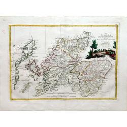
La Scozia Meridionale divisa Nelle sue Contee Particolari di Nuova Projezione.
A detailed map of regions in Scotland by Antonio Zatta. Depicts major cities such as Carrick, Galloway, and Perth, and major river systems in the area. This map also show...
Date: Venice, 1779
Selling price: ????
Please login to see price!
Sold in 2010
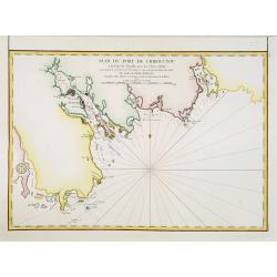
Plan du port de Chibouctou à la cote de l'Acadie avec les cotes voisines. . .
Chart of the vicinity of Halifax Harbor from Chebucto Head to the head of Bedford Basin.Issued in Neptune americo-septentrionale by "Depot Général de la Marine&quo...
Date: Paris, 1779
Selling price: ????
Please login to see price!
Sold in 2013
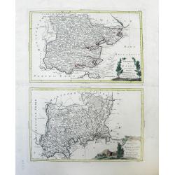
Provincia di Essex di nuova Projezione / Provincia di Middlesex di nuova Projezione. . .
Maps of Essex county (top) and Middlesex county (bottom), a former county, both located in the Southeast Greater London region by Antonio Zatta. The cities of Kingston an...
Date: Venice, 1779
Selling price: ????
Please login to see price!
Sold in 2010
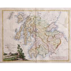
La Scoza Meridionale Divisa Nelle Sue Contee Particolari Di Nuova Projezionev Venezia 1779 Autonio Zatta
Attractive map of Southern Scotland by Antonio Zatta engraved by Giovanni Marco Pitteri one of Italy’s greatest engravers.A copper engraving with beautiful hand colorin...
Date: Venice, 1779
Selling price: ????
Please login to see price!
Sold in 2018
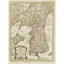
Carte de la Province de Quantong ou Lyau-tong et du Royaume de Kau-Li ou Coree . . .
Map of Korea. The language on the map is Dutch and French. The notation at the bottom indicates that the prime meridian is set at Ferro Island, otherwise known as El Hier...
Date: Paris, 1780
Selling price: ????
Please login to see price!
Sold
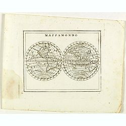
Mappamondo.
Rare world map from "Atlante Novissimo ad uso Dei Giovani Studiosi Contenuto In Carte XXVII.", published by Giovanni Zempel in Rome, ca. 1780.The map is based o...
Date: Rome, 1780
Destroit des Dardanelles..
Decorative view of Istanbul and 'Hellespont'. With a numbered key (1-20) in bottom. Profile view of Istanbul and the Marmora Sea on the horizon.
Date: Paris 1780
Selling price: ????
Please login to see price!
Sold
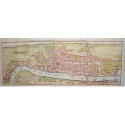
London and Westminster in the Reign of Queen Elizabeth Anno Dom 1563.
A rare 18th century pull out town plan of London, as it was known during the time of Elizabeth I. This work is very much patterned after the famous first large scale plan...
Date: London, 1780
Selling price: ????
Please login to see price!
Sold
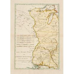
Les États Unis de L'Amerique Septentrionale..
Attractive map covering the Mississippi River and the Great Lakes and Texas region, prepared by R.Bonne and included in his "Atlas Ecyclopédique.."Ri...
Date: Paris 1780
Selling price: ????
Please login to see price!
Sold
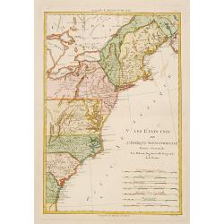
Les États Unis de L''Amerique Septentrionale..
Attractive map covering North Americas east coast. Prepared by R.Bonne and included in his "Atlas Ecyclopédique.."Rigobert Bonne (1727-1795) was engi...
Date: Paris 1780
Selling price: ????
Please login to see price!
Sold
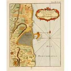
Plan de la Ville Fort et Port d'Alger.
This plan of Algiers, published originally in Bellin's Petit Atlas Maritime and was later issued in vol.III of the Abbé Prévost's "Histoire g&a...
Date: Paris c.1780
Selling price: ????
Please login to see price!
Sold
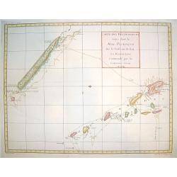
Cartes de Decouvertes faites dans la Pacifique..
A handsome map of New Caledonia and the Hebredees, tracing the track of Captain James Cook's voyage. Attractive coloring.
Date: Paris, ca. 1780
Selling price: ????
Please login to see price!
Sold

A general view of the city of Amsterdam from the Ye.
"A so-called optical print. In the eighteenth and nineteenth centuries there were many popular speciality establishments in Paris, Augsburg and London, which produce...
Date: London 1780
Selling price: ????
Please login to see price!
Sold
Pagi Basileensis qui pars est reipublicae Helvetiorum..
Detailed map of Basle Canton, centered on Basel and Rheinfelden.With fine title cartouche with panoramic view of Basel and heraldic figures like Neptune's, Mercury, Justi...
Date: Augsburg 1780
Selling price: ????
Please login to see price!
Sold in 2013

La Grande Mosquee a la Mekke.
A very fine view of the temple of Mecca.
Date: France, ca. 1780
Selling price: ????
Please login to see price!
Sold
Mappa geographica Asiae Minoris Antiquae..
A detailed of Turkey, Black Sea and Cyprus.
Date: Germany c.1780
Selling price: ????
Please login to see price!
Sold