Browse Listings
![[Title page] Le Theatre du Monde.](/uploads/cache/31307-250x250.jpg)
[Title page] Le Theatre du Monde.
Title page from the atlas "Le Theatre du Monde", published by Roch-Joseph Julien, who was active as a publisher and mapseller in Paris from 1752 - 1780. From 17...
Date: Paris, 1762,1768
Selling price: ????
Please login to see price!
Sold in 2012
Mappa Geogr. JMP: Chinensis Eller Geogr:Charta ofwer China.
Uncommon Swedish map of China by Andrew Akerman (1721-1778), taken from his successful "Atlas Juvenilis eller Geographiska Chartor till ungdomens tienst i methodisk ...
Date: Uppsala, 1768
Selling price: ????
Please login to see price!
Sold in 2011
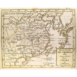
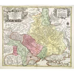
Carte du duche de Luxembourg, . . .
Detailled map of Luxembourg. Relief shown pictorially from his "Atlas Universel".Gilles Robert de Vaugondy (1688–1766), also known as Le Sieur or Monsieur Rob...
Date: Paris, 1754-1768
Selling price: ????
Please login to see price!
Sold in 2011
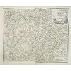
Royaume d'Irlande divisé en ses quatre Provinces.
A detailed map of Ireland from his "Atlas Universel." Gilles Robert de Vaugondy (1688–1766), also known as Le Sieur or Monsieur Robert, and his son, Didier Ro...
Date: Paris, 1753-1768
Selling price: ????
Please login to see price!
Sold in 2013
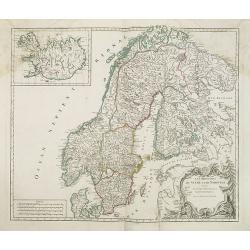
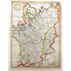
Les royaumes de Suede et de Norvège. . .
Detailed map of Sweden and Norway with inset of Iceland. From his "Atlas Universel".Address has been ereased. Gilles Robert de Vaugondy (1688–1766), also know...
Date: Paris, 1757-1768
Selling price: ????
Please login to see price!
Sold in 2013
Carte géométrique du comté nantois dédiée à Monseigneur le duc d'Aiguillon par Ogée, sous-ingénieur des Ponts et Chaussées au comté de Nantes.
Very rare map of the Brittany coast with Belle Isle and the regions of Vannes, Nantes. In upper left the Morbian Bay. The map is engraved by P. N. Le Roy, who was a ingen...
Date: Paris, 1768
Selling price: ????
Please login to see price!
Sold

Bolton Castle & Richmond Castle in Yorkshire (2 Prints).
Two hand-covered, copper engravings taken from Francis Grose's "Antiquities of England and Wales" published in London by Alex Hogg. The engeravers were Thorton ...
Date: London, c1768
Selling price: ????
Please login to see price!
Sold in 2013
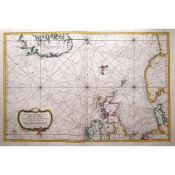
Carte Réduite de Partie de la Mer du Nord comprise entre L'Ecosse, Le Dannemark, La Norwege et l'Islande.
A beautiful chart of the North Sea and part of the Atlantic Ocean, showing Norway, the Faroe Islands, Denmark, the British Isles and Iceland. English towns accessible by ...
Date: Paris, 1768
Selling price: ????
Please login to see price!
Sold in 2014
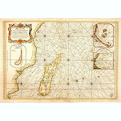
Carte réduite du canal de Mozambique et des isles de Madagascar de France de Bourbon, de Rodrigues et autres. . .
Very large and detailed chart depicting Southern Africa, with Insets: Plan de l'isle de l'Assomption et de son mouillage. -- Plan du port de Secheyles dans l'isle de ce n...
Date: Paris, ca. 1768
Selling price: ????
Please login to see price!
Sold in 2014
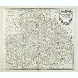
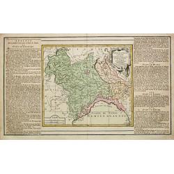
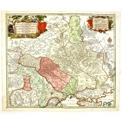
Le Royaume De Boheme, Le Duche De Silesie, et Les Marquisats De Moravie et Lusace. . . 1751
Map of Bohemia, Silesia, Poland, Moravia and Lusatia embellished with decorative title cartouche from his "Atlas Universel".Shows Prague, Breslau, Glogau, Oppel...
Date: Paris, 1768
Selling price: ????
Please login to see price!
Sold in 2018
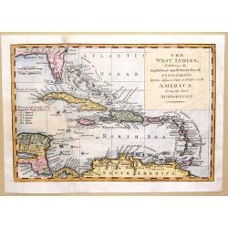
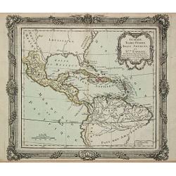
The West Indies Exhibiting the English French Spanish Dutch & Danish Settlements with the Adjacent Parts of North & South America from the Best Authorities
This is a fine map of the Caribbean showing the colonial holdings of Britain, France, Spain, the Netherlands and Denmark after the Treaty of Peace in 1783, by way of a k...
Date: London, 1768
Selling price: ????
Please login to see price!
Sold in 2016
Recueil des Côtes Maritimes de France en 50 feuillets tirées des meilleures cartes gravées et Manuscrites dédié à son Altesse M. le Comte de Clermont...
Very rare Atlas of the coasts of France, first published in 1757 and expanded by Brion de la Tour, who added the province names to the copper plate. The charts are printe...
Date: Paris, Desnos, 1768
Selling price: ????
Please login to see price!
Sold in 2016

Rare etching of a printing office at Haarlem.
A rare etching by the famous Cornelis van Noorde of the offices of the printing firm Joh. Enschede at Haarlem.The etching was produced to accompany the oldest and most be...
Date: Haarlem, 1768
Selling price: ????
Please login to see price!
Sold in 2022
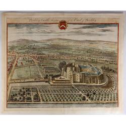
Berkley Castle, the Seat of the Earl of Berkley.
Kip engraved this fine topographical engraving for Sir Robert Atkyns’s “The Ancient and Present State of Gloucestershire”. Kip’s views are widely considered to ...
Date: Amsterdam, 1768
Selling price: ????
Please login to see price!
Sold in 2023
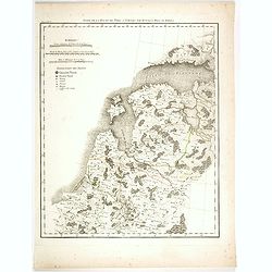
Suite de la route de Paris a Tobolks par Rotnica, Riga et Kipina.
Rare map showing Lithuania, Latvia, Estonia and part of Poland. The map has original out line color and the route taken by Jean Chappe d'Auteroche crossing this area is d...
Date: Paris, 1768
Selling price: ????
Please login to see price!
Sold in 2017
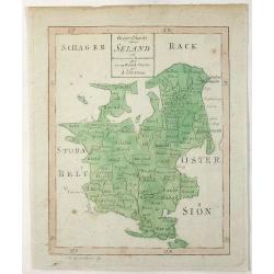
Geogr. Charta Seland. . .
This is an antique map of the Island of Zealand, Denmark made by Andrew Akerman (1721-1778) of Uppsala, Sweden and engraved by E Osterberg. Zealand is the largest and m...
Date: Uppsala, 1768
Selling price: ????
Please login to see price!
Sold in 2021
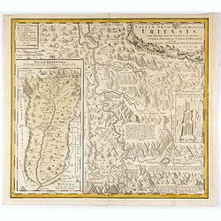
Canton Uri sive Pagus Helvetiae Uriensis cum subditis suis in Valle Lepontina...
Original copper engraving map of Swiss canton Uri. In lower left corner "Valle Leventina Das Liviner Thals, so dem Löblichen Canton Uri eigen gehört" and anot...
Date: Nuremberg, 1768
Selling price: ????
Please login to see price!
Sold in 2021
![[Title page for] Nouvel itineraire général. . .](/uploads/cache/47759-250x250.jpg)
[Title page for] Nouvel itineraire général. . .
Title page of "Nouvel Itinéraire général comprenant toutes les grandes routes et chemins de communication des provinces de France, des Iles Britanniques, de l'Esp...
Date: Paris, 1768
Selling price: ????
Please login to see price!
Sold in 2023

Two Pythons, Scarlet Ibis and Shama.
Plate LXII from Albertus Seba's 'Thesaurus', displaying a pair of snakes, a scarlet Ibis and a small bird on a branch. Albertus Seba (1665-1736) was a Dutch apothecary, z...
Date: Amsterdam, 1734-1769
Selling price: ????
Please login to see price!
Sold in 2021
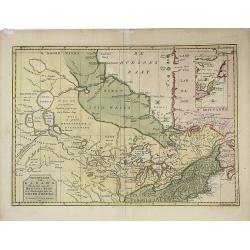
Nieuwe Kaart van Kanada, De Landen aan de Hudson's-Baay en de Noordwestelyke deelen van Noord-Amerika. . .
A decorative, interesting map of Canada and the Upper Midwest. It is centered on the Great Lakes and Hudson's Bay and was published by Issak Tirion. The map depicts the r...
Date: Amsterdam, 1769
Selling price: ????
Please login to see price!
Sold in 2022
PLAN DE FLORENCE.
A superb and scarce map of Florence by Lalande, from from 'Voyage en Italie' by LALANDE, J. J. DE.., with a detailed legend.Joseph Jérôme Lefrançois de Lalande , 11 Ju...
Date: Paris, 1769
Selling price: ????
Please login to see price!
Sold in 2021
Carte Des Entrees De La Tamise
This is a beautiful antique nautical chart of the east coast of England, focusing on the counties of Suffolk Kent and Essex as well as the entrance to the Thames River. T...
Date: Paris, 1769
Selling price: ????
Please login to see price!
Sold in 2023
Grondvlakte van Nieuw Orleans, de Hoosdstad van Louisiana / De Uitloop van de Rivier Missisippi / De oostelyke Ingang van de Missisippi, met een Plan van het Fort, 't Welk het Kanaal Beheerscht
A sought-after, beautiful, decorative sheet that shows three maps arranged around a significant compass rose. This work represents Tirion's version of a map that was firs...
Date: Amsterdam, ca. 1769
Selling price: ????
Please login to see price!
Sold
NoordHollands..WestFriesland..Dregterland..Koggen enz.
A very detailed map of North Holland also showing the famous cities Enkhuizen, Hoorn and Alkmaar. With an inset of the islands Texel, Vlieland and Terschelling.
Date: Amsterdam 1769
Selling price: ????
Please login to see price!
Sold
Guayana, Terre Ferme, Isles Antilles et N.lle Espagne.
Louis Brion de la Tour (1756-1823), ' Atlas Géneral, Civil et Ecclésiastique', 1766, ' Atlas Général', 1790-98. Louis Charles Desnos (fl.1750-70), Le Rouge's 'Atlas N...
Date: Paris, 1769
Selling price: ????
Please login to see price!
Sold
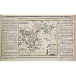
Turquie Européenne avec les états qui en sont tributaires.
Louis Brion de la Tour (1756-1823), ' Atlas Géneral, Civil et Ecclésiastique', 1766, ' Atlas Général', 1790-98. Louis Charles Desnos (fl.1750-70), Le Rouge's 'Atlas N...
Date: Paris, 1769
Selling price: ????
Please login to see price!
Sold
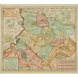
Nieuwe kaart van 't Kwartier Zutphen..
Map of the northern part of The Duchy Gelre, with Zutphen and Deventer.
Date: Amsterdam 1769
Selling price: ????
Please login to see price!
Sold
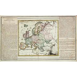
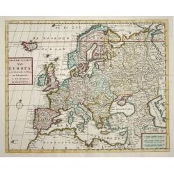
l' Europe.
Louis Brion de la Tour (1756-1823), ' Atlas Géneral, Civil et Ecclésiastique', 1766, ' Atlas Général', 1790-98. Louis Charles Desnos (fl.1750-70), Le Rouge's 'Atlas N...
Date: Paris, 1769
Selling price: ????
Please login to see price!
Sold
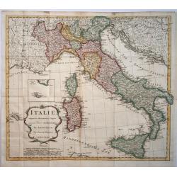
Partie de l' Italy Comprenant les etats du Roy de Sardaigne, de Milan, Parme et Génes.
Louis Brion de la Tour (1756-1823), ' Atlas Géneral, Civil et Ecclésiastique', 1766, ' Atlas Général', 1790-98. Louis Charles Desnos (fl.1750-70), Le Rouge's 'Atlas N...
Date: Paris, 1769
Selling price: ????
Please login to see price!
Sold
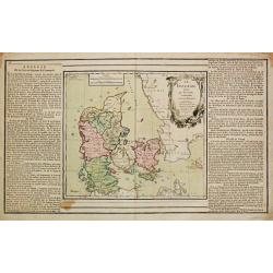
Le Danemark
Louis Brion de la Tour (1756-1823), ' Atlas Géneral, Civil et Ecclésiastique', 1766, ' Atlas Général', 1790-98. Louis Charles Desnos (fl.1750-70), Le Rouge's 'Atlas N...
Date: Paris, 1769
Selling price: ????
Please login to see price!
Sold
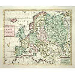
Nieuwe Kaart van Europa
Nice map of Europe extending to include Iceland. Political divisions are delineated in original color and major cities are located.
Date: Amsterdam 1769
Selling price: ????
Please login to see price!
Sold
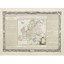
L'Europe Dressée..
Map of Europe, with an explanatory text on left/right sides. The map and the text are surrounded by a decorative frame, wrapped in garlands, on which stand out the instru...
Date: Paris, 1768-1769
Selling price: ????
Please login to see price!
Sold
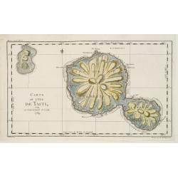
Carte de L'Isle de Taiti par Le Lieutenant J.Cook.
This copper engraved map of the islands of Tahiti is one of the earliest charts of the island. Fully engraved to show its unique mountainous topography and rivers radiati...
Date: Paris 1769
Selling price: ????
Please login to see price!
Sold
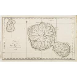
Carte de L'Isle de Taiti par Le Lieutenant J.Cook.
A good engraved map of the island Tahiti, one of the earliest charts of the island. Fully engraved to show its unique mountainous topography and rivers radiating from the...
Date: Paris, 1769
Selling price: ????
Please login to see price!
Sold in 2012
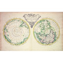
Le Globe Terrestre vû en convêxe par les deux Poles...
Scarce map showing the World in twin-hemispheres, centered on the Poles. Ornamental uncolored title cartouche. Northern Hemisphere shows large "Mer de l'Ouest"....
Date: Paris, 1769
Selling price: ????
Please login to see price!
Sold
Le Danemark
Louis Brion de la Tour (1756-1823), ' Atlas Géneral, Civil et Ecclésiastique', 1766, ' Atlas Général', 1790-98. Louis Charles Desnos (fl.1750-70), Le Rouge's 'Atlas N...
Date: Paris, 1769
Selling price: ????
Please login to see price!
Sold
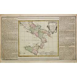
Etats des deux Siciles.
Louis Brion de la Tour (1756-1823), ' Atlas Géneral, Civil et Ecclésiastique', 1766, ' Atlas Général', 1790-98. Louis Charles Desnos (fl.1750-70), Le Rouge's 'Atlas N...
Date: Paris, 1769
Selling price: ????
Please login to see price!
Sold
Nieuwe Kaart van Europa
Nice map of Europe extending to include Iceland. Political divisions are delineated in original color and major cities are located.
Date: Amsterdam, 1769
Selling price: ????
Please login to see price!
Sold
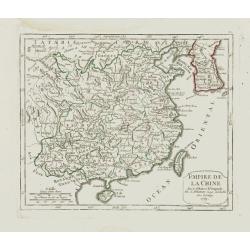
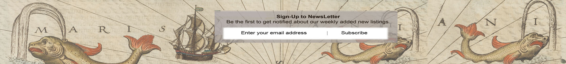
Empire de la Chine.
Small detailed map showing the eastern part of China as well as Korea. Including Taiwan and Hainan. Dated 1769.From Atlas Portatif Universel, by Robert de Vaugondy.Page 7...
Date: Paris, later than 1769
Selling price: ????
Please login to see price!
Sold in 2008
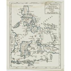
Isles Philippines et Moluques.
Small detailed map showing the Philippines and part of Indonesia. From Atlas Portatif Universel, by Robert de Vaugondy.Page 73 outside border top right. Mary Sponberg Ped...
Date: Paris, later than 1769
Selling price: ????
Please login to see price!
Sold in 2015
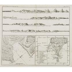
Plan de la Baye du Bon succès dans le détroit de le Maire. / Carte de la partie S. E. de la Terre de Feu. . . / 4 profils figurant la Terre de feu. Tome II Pl. 6.
Charts of the Detroit of Le Maire and of Tierra del Fuego in Spanish for "Land of Fire" situated on the southernmost tip of the South American mainland by the S...
Date: Paris, 1769
Selling price: ????
Please login to see price!
Sold in 2008
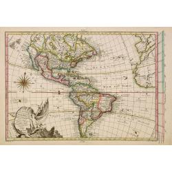
Carte Nouvel le D'Amerique pour les..
Fine detailed and uncommon map of America. This map is most notable for it's depiction of Mer de L'Ouest or "Sea of the West": a great sea, easily the size of t...
Date: Paris, 1769
Selling price: ????
Please login to see price!
Sold in 2010
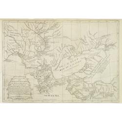
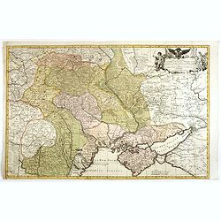
A New & Accurate Map of the Krim Tartary, the Sea of Azof, and Parts of the Rivers Dneper, Bog and Kuban.
Interesting, engraved map of the northern Black Sea and southern Ukraine regions, during the period of hostilities between the Turks and Russians, 1768-74. Published in t...
Date: London, 1769
Selling price: ????
Please login to see price!
Sold in 2013
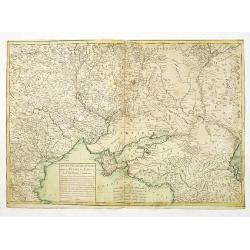
Nouveau théâtre de la guerre entre les Russes les turcs et les polonois confédérés.
Very rare separately published map of Crime region. With a large title cartouche lower left "Nouveau theâtre de la guerre entre les russes, les turcs et les polonoi...
Date: Paris, 1769
Selling price: ????
Please login to see price!
Sold in 2010
![[SET OF 5 MAPS OF THE CASPIAN SEA, RUSSIA, ca. 1769]](/uploads/cache/91829-250x250.jpg)
[SET OF 5 MAPS OF THE CASPIAN SEA, RUSSIA, ca. 1769]
Interesting set of five copper-engraved maps of the Caspian Sea by or after D'Anville, dating to around 1769. List of the maps: 1: Premiere Révolution de la mer Caspie...
Date: Paris, c1769
Selling price: ????
Please login to see price!
Sold in 2011
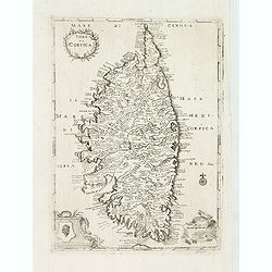
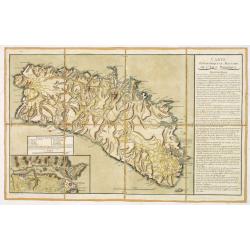
Isola di Corsica.
A very rare map of Corsica, published in " Relazione della Corsica, "which was an Italian translation of the work by Boswell " An Account of Corsica,"...
Date: London, 1769
Selling price: ????
Please login to see price!
Sold
(Dalmatien). Lower left sheet from the famous wall map 'Mappa Geographica novissima Regni Hungariae divisi in suos Comitatus'.
Lower left sheet from the famous wall map "Mappa Geographica novissima Regni Hungariae divisi in suos Comitatus" of Hungary. This part depicting part of Dalmati...
Date: Vienna, 1769
Selling price: ????
Please login to see price!
Sold
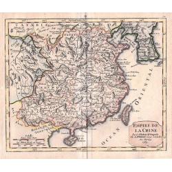
Empire de la Chine.
An attractive small detailed map showing the eastern part of China as well as Korea. Including Taiwan and Hainan. Dated 1769 in the cartouche.From ‘Atlas Portatif Unive...
Date: Paris, 1769
Selling price: ????
Please login to see price!
Sold in 2016
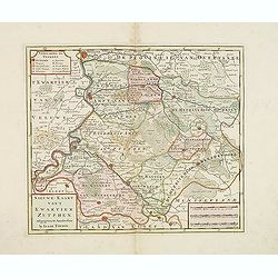
Nieuwe kaart van 't Kwartier Zutphen. . .
Map of the northern part of The Duchy Gelre, with Zutphen and Deventer.Isaac Tirion was born in Utrecht ca. 1705. He came to Amsterdam ca. 1725. Tirion published a number...
Date: Amsterdam, 1769
Selling price: ????
Please login to see price!
Sold in 2013
Nieuwe Kaart van Italie na de Nieuwste waarnemingen van de l'Isle en andere
Handsome and detailed map showing Italy as well as Corsica, Sardinia, Minorca, Croatia, Albania, Dalmatia, a bit of Provence, Malta and the northern coast of Africa. The ...
Date: Amsterdam 1769
Selling price: ????
Please login to see price!
Sold in 2014
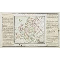
L'Europe Dressée. . .
Map of Europe, with an explanatory text on left and right sides.
Date: Paris, 1768-1769
Selling price: ????
Please login to see price!
Sold in 2016
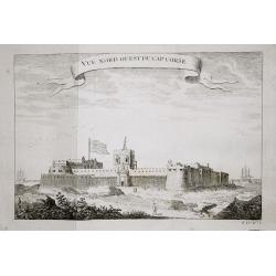
Vue nord ouest du Cap Corse.
The English fortresses at Cape Corse.From a French edition of Prévost d' Exile's ' Histoire. des Voyages', 1738-75.
Date: Paris, 1769
Selling price: ????
Please login to see price!
Sold in 2018
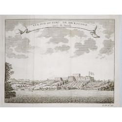
Plan of the English fortresses at Dickscove Vue du sud du fort de Dickscove.
The English fortresses at Dickscove.From a French edition of Prévost d' Exile's ' Histoire. des Voyages', 1738-75.
Date: Paris, 1769
Selling price: ????
Please login to see price!
Sold in 2020
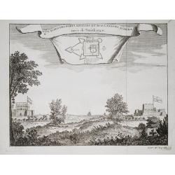
Vue nord des forts anglois et Hollandois d'Akra.
The Dutch and English forts at Accra. From a French edition of Prévost d' Exile's "Histoire des Voyages", 1738-1775. Crevecoeur, the Dutch fort and the English...
Date: Paris, 1769
Selling price: ????
Please login to see price!
Sold in 2018
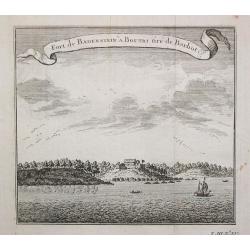
Fort de Badenstein a Boutri.
Fortress Badenstein at Boutri.From a French edition of Prévost d' Exile's ' Histoire. des Voyages', 1738-75.
Date: Paris, 1769
Selling price: ????
Please login to see price!
Sold in 2018
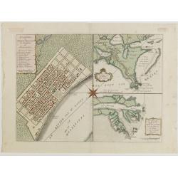
Grondvlakte van Nieuw Orleans, de Hoosdstad van Louisiana / De Uitloop van de Rivier Missisippi / De oostelyke Ingang van de Missisippi, met een Plan van het Fort, 't Welk het Kanaal Beheerscht
A sought-after, beautiful, decorative sheet that shows three maps arranged around a large compass rose. This work represents Tirion's version of a first executed map by D...
Date: Amsterdam, ca. 1769
Selling price: ????
Please login to see price!
Sold in 2015
Nieuwe kaart van Kanada . . .
Nice map of the Bay of Hudson, In Labrador a small inset of Nova Scotia. The map is dated 1769. All text is in Dutch. The map shows the region shortly after the conclusio...
Date: Amsterdam, 1769
Selling price: ????
Please login to see price!
Sold in 2016
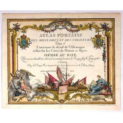
Atlas Portatif des Milataires et des Voyageurs (Title Page).
Decorative title page by G. Le Rouge, who was lieutenant in the regiment of Saxe before establishing himself as publisher, compiler and editor of maps at the "rue de...
Date: Paris , 1769
Selling price: ????
Please login to see price!
Sold in 2017
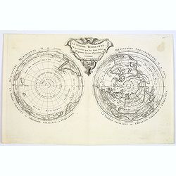
Le Globe Terrestre vu en convexe par les deux Poles, l'Equateur servant d'horison.
The rare double polar hemisphere world map, based on Cassini's projection. There are some geographical anomalies, Greenland is connected to Canada, the Mer de l'Ouest in ...
Date: Paris, 1769
Selling price: ????
Please login to see price!
Sold in 2017
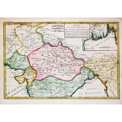
Carte exacte d'une Partie de L'Empire de Russie et de la Pologne meridionale renfermant l'Ukraine . . .
Rare map of Eastern Europe published by Facius Brothers, published in Bonn, including Poland, Lithuania, Russia and Ukraine. This is the first edition of the map, which w...
Date: Bonn, 1769
Selling price: ????
Please login to see price!
Sold in 2022
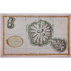
Chart of the Island Otaheite by Capt'n Cook.
Cook's mission on his First Voyage to the South Seas was to observe the passage of Venus across the Sun in 1769, at the request of the Royal Society. In the three months ...
Date: London, 1769
Selling price: ????
Please login to see price!
Sold in 2018
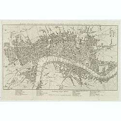
Accurater Plan der Stadt London nebst Westminster, Southwark und den neu angebauteten Haeusern vom Jahr 1767.
Uncommon plan of London with Hyde Park, Sadlers Wells, Mile End, Newington Butts. Underneath the plan a translation of English words used in the map into German below.Sig...
Date: Berlin, 1770
Selling price: ????
Please login to see price!
Sold in 2012
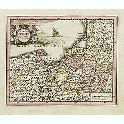
Regni Prussiae accurata delineatio.
Uncommon map of Prussia. The originally colored title cartouche is surrounded by mythological figures. From Atlas Portatif.
Date: Nuremberg, ca. 1770
Selling price: ????
Please login to see price!
Sold in 2012
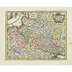
Regnum Poloniae ejusque confinis.
Uncommon map of Poland. From Atlas Portatif.
Date: Nuremberg, ca. 1770
Selling price: ????
Please login to see price!
Sold in 2012
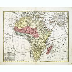
Africa concinnata secundum observationes...
Lotter gives credit in the title cartouche to Guillaume De L'Isle. The Nile is correctly shown with its origins in Abyssinia and the other major rivers are shown fairly a...
Date: Augsburg, ca.1770
Selling price: ????
Please login to see price!
Sold in 2012
Russia in Europe by Thos. Bowen
Showing "Russia in Europe" by Thomas Bowen. It was engraved for and published by "Barlow's General History of Europe" in about 1770. The map covers th...
Date: London, c. 1770
Selling price: ????
Please login to see price!
Sold in 2015
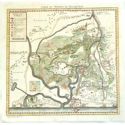
Carte du District de Tranquebar.
A detailed map of Tharangambadi,(Tranquebar & vicinity) an early trading colony controlled by Denmark. It is in the current Indian state of Tamil Nadu on the Coromand...
Date: Amsterdam, 1770
Selling price: ????
Please login to see price!
Sold in 2015
Theatrum belli Russorum Victoriis illustratum sive Nova et accurata Turcicarum et Tartaricum. . .
This is the re-issue of Seutter's map with the Privilege in lower left part. Uncommon and decorative map of Ukraine, showing the theatre of the Russo-Turkish War in the U...
Date: Nuremberg, ca. 1770
Selling price: ????
Please login to see price!
Sold in 2016
Amplissima Ucraniae Regio, Palatinatus Kioviensem et Braclaviensem. . .
This is the re-issue of Seutter's map of Ukraine, with privilege underneath the title cartouche. With excellent detail of the topography, including rivers, hills, etc.Dec...
Date: Nuremberg, ca. 1770
Selling price: ????
Please login to see price!
Sold in 2013
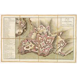
Plan du fort Saint-Philippe dans L'isle de Minorque.
A military plan of Fort St. Philip with a key to the left, with references to the fortifications de San Carlos (Q) et Malborough (R). In upper right corner "N°.3.&q...
Date: Paris, ca. 1770
Selling price: ????
Please login to see price!
Sold in 2013
Carte Topographique et Militaire de L'Isle Minorque.
A fine map of Minorca with inset of the Bay of Mahon. With an extensive "Instruction" to the right "ette Carte levée et dessinée par des Officiers de l'A...
Date: Paris, ca. 1770
Selling price: ????
Please login to see price!
Sold in 2013
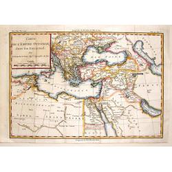
Carte de L'Empire Ottoman Dans Son Etat Actuel.
Fine detailed copper engraved map of the Ottoman Empire in its actual state surrounding the area that is Turkey today. Block cartouche. Louis Brion de la Tour (1756-1823...
Date: Paris, 1770
Selling price: ????
Please login to see price!
Sold in 2015
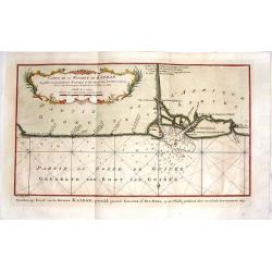
Carte de la Riviere de Kalbar.
Detailed coastal map of the Guinea coast of West Africa based on the 1699 voyage of James Barbot and John Grazilhier to the Kalabar River. This was the heart of the slave...
Date: Amsterdam, 1770
Selling price: ????
Please login to see price!
Sold in 2015
Amplissima Ucraniae Regio, Palatinatus Kioviensem et Braclaviensem. . .
Seutter's map of Ukraine, with privilege underneath the title cartouche. With excellent detail of the topography, including rivers, hills, etc.Decorated with two attracti...
Date: Nuremberg, ca. 1770
Selling price: ????
Please login to see price!
Sold in 2014
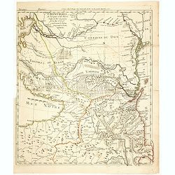
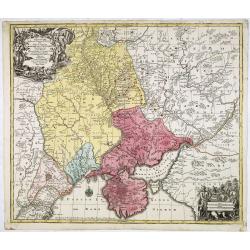
Frontieres de Turquie et de Russie Entre la Mer Caspienne et la Mer d'Asof renfermant le Kuban la Grande et Petitte Kabardie
Fine and rare map centered on present-day Georgia, Armenia and Azerbaijan. Depicting the progress of the Russo-Turkish war between 1768-1774. In bottom northern part of A...
Date: Paris, 1770
Selling price: ????
Please login to see price!
Sold in 2014
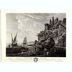
Ravage près de Tivoli.
Fine copper engraving after a design by Claude Joseph Vernet (1714 Avignon - 1789 Paris) and engraved by Jacques Aliamet. (1726 Abbeville-1788 Paris)
Date: Paris, Jean, ca.1770
Selling price: ????
Please login to see price!
Sold in 2014
Carte de la Partie Superieure de l' Inde en deça du Gange.
Rigobert Bonne (1727-1795), French cartographer. His maps are found in a.o. Atlas Moderne (1762), Raynal's Histoire Philos. du Commerce des Indes (1774) and Atlas Encyclo...
Date: Paris, c. 1770
Selling price: ????
Please login to see price!
Sold in 2020
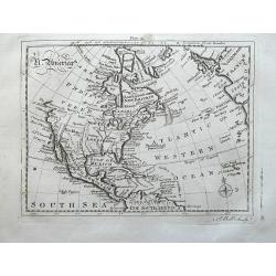
N. America.
Uncommon map of North America, with unfinished coast north of California. Shows "Quivira" and "The supposed Str. of Annian". Locates Indian tribes.
Date: London, ca. 1770
Selling price: ????
Please login to see price!
Sold in 2014
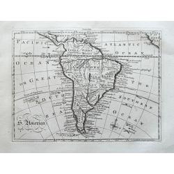
S. America.
Uncommon map of South America. With many details and place names. With small specks of land "Terra Australis", "Port discover'd by Sir Francis Drake",...
Date: London, ca. 1770
Selling price: ????
Please login to see price!
Sold in 2014
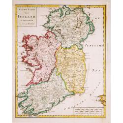
Nieuwe Kaart van Ierland.
28Izaak Tirion (d. 1769) Amsterdam publisher. His ' Nieuwe en beknopte handatlas' saw 6 editions between before 1740 and after 1784. Also ' Tegenwoordige staat van alle v...
Date: Amsterdam, c. 1770
Selling price: ????
Please login to see price!
Sold in 2015