Browse Listings
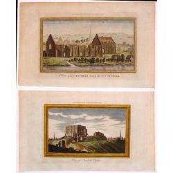
Two Hand-Colored Views of the Ruins of Ancient British Castles.
Two hand-colored views of English castles including: - "View of Norwich Castle" & - "A View of Lestwithiel Palace in Cornwall" These are copper ...
Date: London, 1770
Selling price: ????
Please login to see price!
Sold in 2018
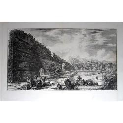
Veduta degli avanzi del Castro Pretorio nella Villa Adriana a Tivoli.
Original etching from the “Vedute di Roma”, which is the name for a collection of 135 monumental etchings by Giovanni Battista Piranesi. With those etchings he had a ...
Date: Rome, 1770
Selling price: ????
Please login to see price!
Sold in 2014
![La Destruction de la flotte ottomanne par l'escadre russe sous les ordres de S.E. Mr le comte Orlow. Dans le port de Chisme la nuit du 7m juillet 1770 [together with] (Map of Bay between Cesme and Cios)](/uploads/cache/35506-250x250.jpg)
La Destruction de la flotte ottomanne par l'escadre russe sous les ordres de S.E. Mr le comte Orlow. Dans le port de Chisme la nuit du 7m juillet 1770 [together with] (Map of Bay between Cesme and Cios)
Very rare separately published print showing the siege of Cesme on 7th July 1770. The battle took place during the Russian Turkish war of 1768-1774 at Cesme, near Izmir i...
Date: Paris, after 1770
Selling price: ????
Please login to see price!
Sold in 2015
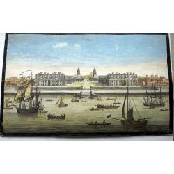
A View of the Royal Hospital at Greenwich.
An optical print of the Christopher Wren Old Royal Naval College from the Thames.
Date: London, circa 1770
Selling price: ????
Please login to see price!
Sold in 2022

Vue et Perspective de la Superbe Colomnade de Versailles.
Striking optical print featuring the columns and the gardens at Versailles, near Paris. France. In the eighteenth and nineteenth centuries many specialty establishments i...
Date: Paris, 1770
Selling price: ????
Please login to see price!
Sold in 2016
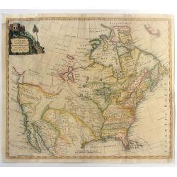
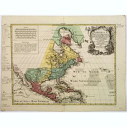
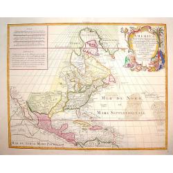
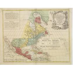
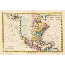
North America Drawn & Engraved from the best Maps & Charts.
Important early hand-colored, copper engraved map of the British Colonies and the whole of North America, shortly after the conclusion of the French & Indian War and ...
Date: London, 1770
Selling price: ????
Please login to see price!
Sold in 2015
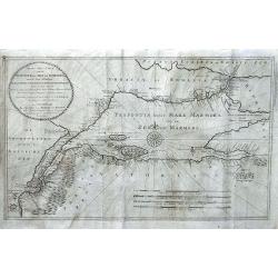
Nieuwe Zee-Caart van de Propontis of Zee van Marmora, met de Twee Straaten Hellespont en t Naauw van Constantinopolen... P.D. Bohn 1770...
Very rare chart depicting the Sea of Marmora and the surrounding regions, including Constantinopel, Hellespont, the Dardeanelle Strait, part of Turkey and Greece. chart i...
Date: Amsterdam, 1770
Selling price: ????
Please login to see price!
Sold in 2016
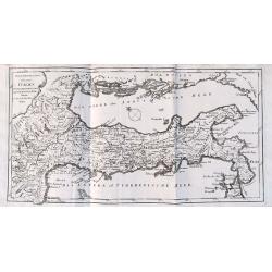
Neue Vorstellung von gantz Italien.
Unusual map of Italy during Roman times - from South Tyrol to Calabria, including a small part of Sicily. With numerous ancient place names. Published in "Neue Samml...
Date: Frankfurt, 1770
Selling price: ????
Please login to see price!
Sold in 2016

Vue de la Nouvelle Decoration de la Foire St. Germain.
A hand colored optical print published in Paris by Jacques Chereau in about 1770. During the 18th century there were several manufacturers of optical viewing devices and...
Date: Paris, ca. 1770
Selling price: ????
Please login to see price!
Sold in 2019
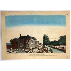
Vue d'Une Partie du Bois de la Haye.
A hand colored optical print published in Paris by Jacques Chereau in about 1770. During the 18th century there were several manufacturers of optical viewing devices and ...
Date: Paris, ca. 1770
Selling price: ????
Please login to see price!
Sold in 2019
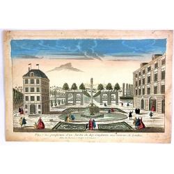
Vue et Perspective d'Une Jardin du Roy d'Angleterre aux Environs de Londres.
A hand colored optical print of the King's garden in London, published in Paris by Basset in about 1770. During the 18th century there were several manufacturers of optic...
Date: Paris, ca. 1770
Selling price: ????
Please login to see price!
Sold in 2018
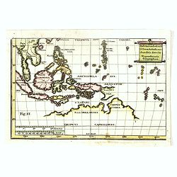
Insularum Indicaru & Terrae Australis necdum fatis derectae Repraesentatio Geographica.
The map shows whole South-East Asia with partial Australia which only on the north-west coast was discovered.Read more Early maps of South East Asia [+]
Date: 1770
Selling price: ????
Please login to see price!
Sold in 2021
![Illumination en réjouissance du Mariage de Louis Auguste Dauphin de France avec l'Archiduchesse Marie Antoinette sœur de l'Empereur : [16 mai 1770].](/uploads/cache/37420-250x250.jpg)
Illumination en réjouissance du Mariage de Louis Auguste Dauphin de France avec l'Archiduchesse Marie Antoinette sœur de l'Empereur : [16 mai 1770].
J. Chereau was a publisher of optical print, established in Paris, rue St.Jacques. In the eighteenth and nineteenth centuries there were many popular speciality establish...
Date: Paris, ca. 1770
Selling price: ????
Please login to see price!
Sold in 2017
![[Titlepage] Atlas Novus sive Tabulae Geographicae Totius Orbis Faciem. . .](/uploads/cache/38078-250x250.jpg)
[Titlepage] Atlas Novus sive Tabulae Geographicae Totius Orbis Faciem. . .
Very decorative title page from Atlas Novus printed by Tobias Conrad Lotter. Large, elaborately engraved sheet with numerous allegorical figures. The middle of the title ...
Date: Augsburg, 1770
Selling price: ????
Please login to see price!
Sold in 2017
America Septentrionalis, Concinnata juxta Observationes..
This exemplar represents Lotter's version of Delisle's foundation map of North America, published in 1700. The Great Lakes are actually based on the Coronelli model, whic...
Date: Augsburg, ca. 1770
Selling price: ????
Please login to see price!
Sold in 2018
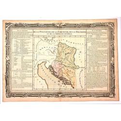
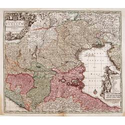
De la Pannonie, De la Liburnie, De la Dalmatie et de la Grece en General.
Fine map of what is now Croatia. By brion de la Tour and Charles Desnos in Paris in 1770. The map has much French text on either side and a very fancy border that was eng...
Date: Paris , 1770
Selling price: ????
Please login to see price!
Sold in 2017
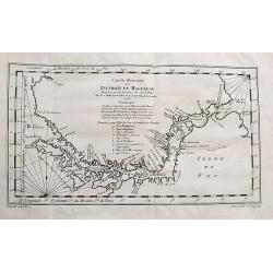
Carte Reduite Du Détroit de Magellan...
Bellin's important and interesting map of the Straits of Magellan and parts of Tierra del Fuego. Extends from Cap des Vierges to Cap de la Victoire. Indicating many bays,...
Date: Paris, ca. 1770
Selling price: ????
Please login to see price!
Sold in 2017
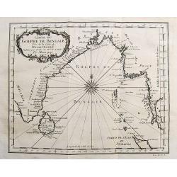
Carte du Golphe de Bengale...
Nice chart of the Bay of Bengal. The map extends from Malabar to Sumatra and today Phuket area in Thailand. Including Pegu, Ceylon, and the Andaman and Nicobar Islands. N...
Date: Paris, ca. 1770
Selling price: ????
Please login to see price!
Sold in 2017
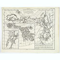
Nouvelle representation des cotes nord et est de l'Asie. . .
Three maps on one sheet. Depicting three maps centered on mainland China, Hokkaido and Kamtschadka in three different visions.Korea and Quelpaerts indicated, but no town....
Date: Paris, 1770
Selling price: ????
Please login to see price!
Sold in 2017
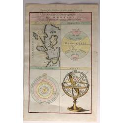
The Terms and Principles of Geography with Their Astrological Connections.
An interesting set of 4 images on one sheet, including an armillary sphere, a model of the solar system, geographical circles, and a model of the various geographical fea...
Date: London, 1770
Selling price: ????
Please login to see price!
Sold in 2019
![[Part of an Unknown Map.]](/uploads/cache/98331-250x250.jpg)
[Part of an Unknown Map.]
Upper left sheet of a large four sheet map. The most pronounced label on he map is "Comte de Virnenborg", Virneburg is a municipality in the district of Mayen-K...
Date: Paris, ca. 1770
Selling price: ????
Please login to see price!
Sold in 2017
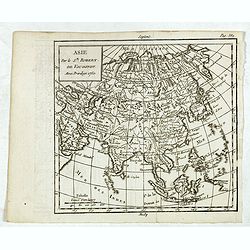
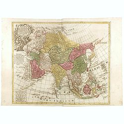
Asie.
Map of Asia. The map is of interest for the use of East Sea, the sea between Korea and Japan, here called "M. de Coree".
Date: Paris, 1770
Selling price: ????
Please login to see price!
Sold in 2017
Asia Concinnata Secundum Observationes Academiae Regalis . . .
A version of De L'Isle's map. T.C. Lotter married M. Seutter's daughter in 1740 and succeeded him in 1756. Lotter used the copperplate of Seutter, he only changed the nam...
Date: Augsburg, ca. 1770
Selling price: ????
Please login to see price!
Sold in 2025
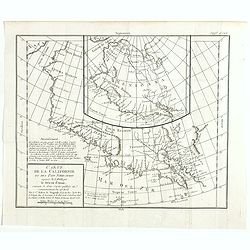
Carte de la Californie et des Pays Nord-Ouest..
From Diderot's Encyclopedia. The main map shows California and the north west coast as depicted in a four-sheet map of America, published by Claes Jansz Visscher in 1612:...
Date: Paris, 1770
Selling price: ????
Please login to see price!
Sold in 2020
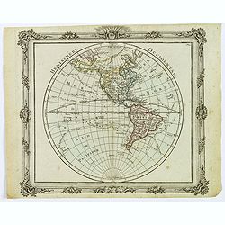
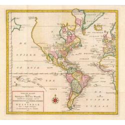
Hemisphere Occidental.
This is a most informative map of the Western Hemisphere by Brion de la Tour, dating to 1786. It covers the entire hemisphere in generous detail, covering North America a...
Date: Paris, ca 1770
Selling price: ????
Please login to see price!
Sold in 2019
![Vue de la Rue grande vers l'Eglise du Sud des Presbiteriennes a Boston. [Vue de Boston].](/uploads/cache/43546-250x250.jpg)
Vue de la Rue grande vers l'Eglise du Sud des Presbiteriennes a Boston. [Vue de Boston].
A "vue d'optique" or perspective view. These popular engravings were published in Europe during the last half of the 18th century. They were meant to be seen th...
Date: Augsburg, 1770
Selling price: ????
Please login to see price!
Sold in 2019
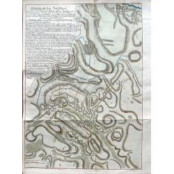
Feldschlacht bey Baschkiwizi in welcher Fürst Alexander Gallizin auf dem Marsche von Tschernowiz gegen Chozim von 70.000 Tartarn und Türken. . .
A very rare plan of the battle near Chotyn in the year 1769. The city was besieged by the Russian prince Alexander Galitzine. Khotyn is a city in Chernivtsi Oblast of wes...
Date: Vienna, ca 1770
Selling price: ????
Please login to see price!
Sold in 2019
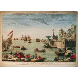
Vue de Malthe du côté du Fort.
An old colored optical view of Valetta, the capital of the Isle of Malta. On the right hand the fortresses. On the left is an on going sea battle. Made by an anonymous en...
Date: Unknown, ca 1770
Selling price: ????
Please login to see price!
Sold in 2019
![Plan of the Town of Chockzin [Khotyn] taken from the Turks by the Russians under Marshal Munich. [Khotin]](/uploads/cache/83608-250x250.jpg)
Plan of the Town of Chockzin [Khotyn] taken from the Turks by the Russians under Marshal Munich. [Khotin]
A rare, nicely colored map of the town of Chokzin or Choczim in the historical region of Moldavia, which spans today's Ukraine, Romania and Moldavia. Showing the district...
Date: London, 1770
Selling price: ????
Please login to see price!
Sold in 2020
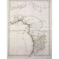
Guinee Guinee IIe. Feuille.
An example of Bonne's 1770 decorative map of West Africa. It covers from the Gold Coast (Ghana), south around the Bight of Benin (Biafara) to Gabon, Congo and Angola. It...
Date: Paris, 1770
Selling price: ????
Please login to see price!
Sold in 2022
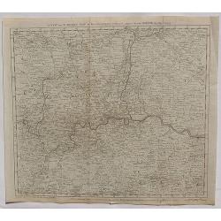
A New and Correct Map of the Countries twenty Miles Round London.
A detailed map of the counties within 20 miles around London by Bowen in 1770. Thomas Bowen (1733-1790) was the son of Emanuel Bowen and became a map maker, engraver and ...
Date: London, 1770
Selling price: ????
Please login to see price!
Sold in 2020
![Carte des Isles du Japon et la Presqu Isle de Coree ... [Schley]](/uploads/cache/84450-250x250.jpg)
Carte des Isles du Japon et la Presqu Isle de Coree ... [Schley]
Map of Japan and Korea, with Taiwan and Chinese cities: Pekin, Canton and Nankin. From the rarer dutch edition by Schley "Origin: Histoire Générale des voyages, ou...
Date: Amsterdam, ca. 1770
Selling price: ????
Please login to see price!
Sold in 2021
![Creation and Fall of Man [Set of Four prints]](/uploads/cache/84536-250x250.jpg)
Creation and Fall of Man [Set of Four prints]
A nice set of four so- called optica-prints, depicting the Creation of Adam, the Eating of the Forbidden Fruit, the Expulsion of Adam and Eve from the Earthly Paradise, a...
Date: Augsburg, ca 1770
Selling price: ????
Please login to see price!
Sold in 2020
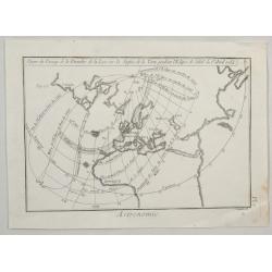
Figure du Passage de la Penombre de la Lune. . .
An interesting map showing the solar eclipse of April 1764 by Scattalglia in Paris in 1770.
Date: Paris, 1770
Selling price: ????
Please login to see price!
Sold in 2020
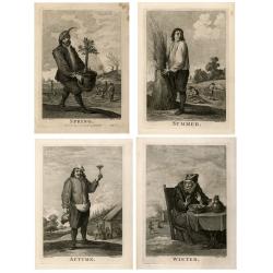
The four seasons.
Morin remains an unknown engraver, Ignatius Fougeron worked around 1760-70 in London and Paul Angier (1725-1757) worked in London too. David Teniers the Younger (1610-169...
Date: London, ca. 1770
Selling price: ????
Please login to see price!
Sold in 2021
![[Lot of 2 maps] Kaart van de onderkoningschappen van Mexico en Nieuw Granada/ Carte de l'Isle de la Martinique, / antique map of the main Carabean islands] Cuba Insula, inset: Havanna portus; Hispanolia Insula.](/uploads/cache/19646-(1)-250x250.jpg)
[Lot of 2 maps] Kaart van de onderkoningschappen van Mexico en Nieuw Granada/ Carte de l'Isle de la Martinique, / antique map of the main Carabean islands] Cuba Insula, inset: Havanna portus; Hispanolia Insula.
Kaart van de onderkoningschappen van Mexico en Nieuw Granada in de Spaansche West-Indien. Carte de l'Isle de la Martinique, 1838 Together 2 maps .- Kaart van de onderk...
Date: Amsterdam, ca 1770
Selling price: ????
Please login to see price!
Sold in 2025
![[Lot of 9 maps and prints]. Kaart van Brasil en de Aller-heiligen Baay waar aan de Hoofdstad legt van Brazil.](/uploads/cache/19736-250x250.jpg)
[Lot of 9 maps and prints]. Kaart van Brasil en de Aller-heiligen Baay waar aan de Hoofdstad legt van Brazil.
[Lot of 9 maps and prints of Brasil].- Kaart van de Aller-heiligen Baay waar aan de Hoofdstad legt van Brazil. - Carte du Bresil Prem. Partie- Suite du Bresil- Suite du ...
Date: Amsterdam, ca 1770
Selling price: ????
Please login to see price!
Sold in 2023
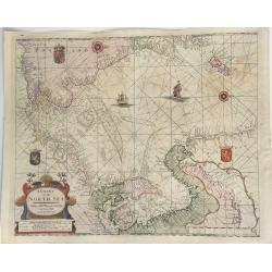
A Chart of the North Sea.
This extremely rare, large sea chart depicts the European North Sea. It is probably the last and possibly unrecorded state of the sea charts of the North Sea produced by ...
Date: London, ca 1770
Selling price: ????
Please login to see price!
Sold in 2023
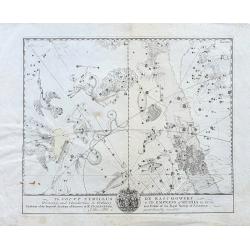
To Count Cyrillus de Rasumowsky...
Very rare copper-engraved celestial chart on hand-laid paper! We could not trace any other example or reference to it. Shows many prominent star constellations. Below wit...
Date: ca. 1770
Selling price: ????
Please login to see price!
Sold in 2022
Carte des Nouvelles découvertes. . .
This map is most notable for it's depiction of "Mer de L'Ouest" or "Sea of the West", a great sea, easily the size of the Mediterranean, to flow from ...
Date: Paris, 1770
Selling price: ????
Please login to see price!
Sold in 2022
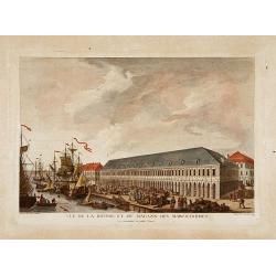
Vue de la bourse et du magazin des marchandises..
Fine view of the stock exchange and storehouses in St.Petersburg. Drawn and engraved under the direction of the imperial Academy of sciences and arts of Russia. After a d...
Date: Saint-Petersburg 1770
Selling price: ????
Please login to see price!
Sold
America Septentrionalis, Concinnata juxta Observationes..
This exemplar represents Lotter?s version of Delisle?s foundation map of North America, published in 1700. The Great Lakes are actually based on the Coronelli model, whic...
Date: Augsburg, ca. 1770
Selling price: ????
Please login to see price!
Sold

Group of 5 engravings of Roman buildings.
"Group of 5 engravings of Roman ancient buildings, together with 2 title pages. The prints are taken from ''Encyclopedie, ou dictionnaire universel raisonn&eacut...
Date: Paris 1770
Selling price: ????
Please login to see price!
Sold
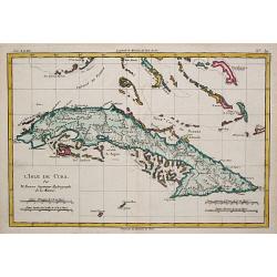
L' Isle de Cuba.
Rigobert Bonne (1727-1795), French cartographer. His maps are found in a.o. Atlas Moderne (1762), Raynal's Histoire Philos. du Commerce des Indes (1774) and Atlas Encyclo...
Date: Paris, c. 1770
Selling price: ????
Please login to see price!
Sold
Dominium Venetum..
Seutter's well-engraved map has a large decorative cartouche. Detailed map centred on Venice.The map is in original wash color and has an uncolored cartouche.
Date: Nuremberg 1770
Selling price: ????
Please login to see price!
Sold
![Mappemonde Terrestre.. [manuscript map]](/uploads/cache/16358-250x250.jpg)
Mappemonde Terrestre.. [manuscript map]
Manuscript double hemisphere world map in brown ink with water color. Finely executed on paper. Showing a north and south pole projection at an angle of 45degrees.
Date: Paris c.1770
Selling price: ????
Please login to see price!
Sold
Theatre de la Guerre dans l'Inde sur la Cote de Coromandel Par M.B.C.T.
VERY RARE MAP of southern part of India, running from Madras to Cape Comorin, interestingly a part is marked in red manuscript Etats de Ayder Aly Kan and colored in pink ...
Date: France, 1770
Selling price: ????
Please login to see price!
Sold
Nieuwe Kaart van de Frankische en Zwabische Kreits.
Izaac Tirion (d. 1769) Amsterdam publisher. His 'Nieuwe en beknopte handatlas' saw 6 editions between before 1740 and after 1784. Also 'Tegenwoordige staat van alle volke...
Date: Amsterdam, c. 1770
Selling price: ????
Please login to see price!
Sold
Carte de l'Empire d'Alemagne..
Detailed map depicting parts of France, Switzerland and Germany. Embellished with allegorical cartouche.
Date: Paris, 1770
Selling price: ????
Please login to see price!
Sold
Carte de la Partie Meridionale de l\'Amerique Meridionale.
A coastal chart of southern South America showing the route of the Centurion from the Island of St. Catherine (Brazil) to the Island of Juan Fernandez (in the Pacific).
Date: Paris c.1770
Selling price: ????
Please login to see price!
Sold
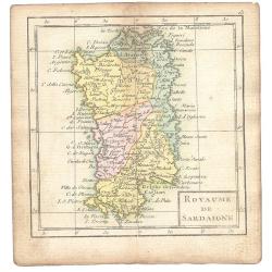
Royaume De Sardaigne
A map showing Sardinia from the uncommon miniature atlas Almanach Geographique ou Petit Atlas Elémentaire, published by Desnos in Paris ca. 1770. Acclaimed French map ...
Date: Paris ca. 1770
Selling price: ????
Please login to see price!
Sold
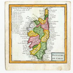
Royaume De Corse.
A map showing Corsica from the uncommon miniature atlas Almanach Geographique ou Petit Atlas Elémentaire, published by Desnos in Paris ca. 1770. Acclaimed French map pub...
Date: Paris ca. 1770
Selling price: ????
Please login to see price!
Sold
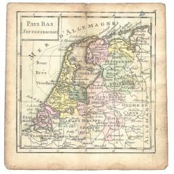
Pays Bas Septentrionalis
A map from the uncommon miniature atlas Almanach Geographique ou Petit Atlas Elémentaire, published by Desnos in Paris ca. 1770. Acclaimed French map publisher and globe...
Date: Paris ca. 1770
Selling price: ????
Please login to see price!
Sold
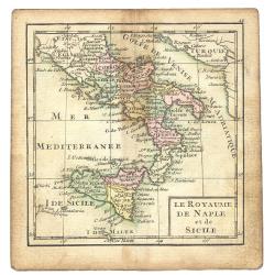
Le Royaume De Naple et de Sicile
A map from the uncommon miniature atlas Almanach Geographique ou Petit Atlas Elémentaire, published by Desnos in Paris ca. 1770. Acclaimed French map publisher and globe...
Date: Paris ca. 1770
Selling price: ????
Please login to see price!
Sold
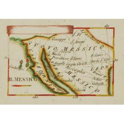
Il Messico.
Uncommon map of Mexico and Baya California.
Date: Italy ca.1770
Selling price: ????
Please login to see price!
Sold
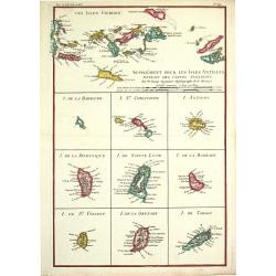
Supplément pour les Isles Antilles.
Rigobert Bonne (1727-1795), French cartographer. His maps are found in a.o. Atlas Moderne (1762), Raynal's Histoire Philos. du Commerce des Indes (1774) and Atlas Encyclo...
Date: Paris, c. 1770
Selling price: ????
Please login to see price!
Sold
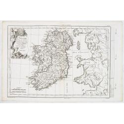
L'Irlande. . .
Fine detailed and uncommon map of Ireland. Prepared by Etienne André Philippe de Pretot (1708-1787) a royal censor and professor of history at the Royal Academy of Scien...
Date: Paris, 1770
Selling price: ????
Please login to see price!
Sold in 2013
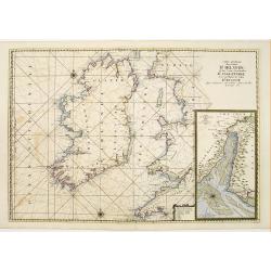
Carte Generale des Costes D'Irelande et des Costes..d'Angleterre avec une Partie de celles D'Ecosse..
Attractive chart. Whole of Ireland and England from Ayr to Plymouth. Large scale inset of the Dee estuary up to Chester in decorative frame. Latitude and longitude scales...
Date: Paris 1770
Selling price: ????
Please login to see price!
Sold
America Septentrionalis, Concinnata juxta Observationes..
This exemplar represents Lotter's version of Delisle's foundation map of North America, published in 1700. The Great Lakes are actually based on the Coronelli model, whic...
Date: Augsburg, ca. 1770
Selling price: ????
Please login to see price!
Sold in 2011
Carte de la Partie Superieure de l' Inde en deça du Gange.
Rigobert Bonne (1727-1795), French cartographer. His maps are found in a.o. Atlas Moderne (1762), Raynal's Histoire Philos. du Commerce des Indes (1774) and Atlas Encyclo...
Date: Paris, c. 1770
Selling price: ????
Please login to see price!
Sold
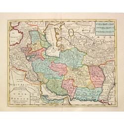
Nieuwe Kaart van 'T Rijk van Persien.
Isaac Tirion's map of the Persian Empire. Isaac Tirion (d. 1769) Amsterdam publisher. His ' Nieuwe en beknopte handatlas' saw 6 editions between before 1740 and after 178...
Date: Amsterdam, c. 1770
Selling price: ????
Please login to see price!
Sold in 2019
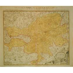
Carte de Namur.
Johann Baptist Homann (1663-1724). Outstanding German cartographer. Founder of the Homann publishing house. After the death of the son Johann Christoph, the firm continue...
Date: Nürnberg, c. 1770
Selling price: ????
Please login to see price!
Sold in 2013
Commitatus Hannoniae.
Johan Baptist Homann (1663-1724). Outstanding German cartographer. Founder of the Homann publishing house. After the death of the son Johann Christoph, the firm continued...
Date: Nürnberg, c. 1770
Selling price: ????
Please login to see price!
Sold in 2013
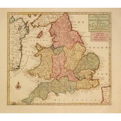
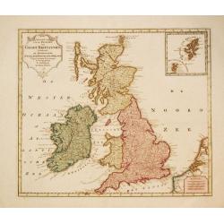
Nieuwe Kaaart van 't Zuider Gedeelte van Groot Britannie behelsende Het Koningryk Engeland.
Izaak Tirion (d. 1769) Amsterdam publisher. His ' Nieuwe en beknopte handatlas' saw 6 editions between before 1740 and after 1784. Also ' Tegenwoordige staat van alle vol...
Date: Amsterdam, c. 1770
Selling price: ????
Please login to see price!
Sold in 2020
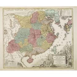
Opulentissimum Sinarum Imperium.
Detailed map of China. Korea, Taiwan and southern tip of Japan.T.C.Lotter married M.Seutter's daughter in 1740 and succeeded him in 1756. Lotter used the copperplate of S...
Date: Augsburg, 1770
Selling price: ????
Please login to see price!
Sold
Amérique Septentrionale.
25Rigobert Bonne (1727-1795), French cartographer. His maps are found in a.o. Atlas Moderne (1762), Raynal's Histoire Philos. du Commerce des Indes (1774) and Atlas Encyc...
Date: Paris, c. 1770
Selling price: ????
Please login to see price!
Sold
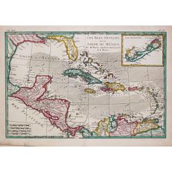
Les Isles Antiles et le Golfe du Méxique / Les Bermudes.
Rigobert Bonne (1727-1795), French cartographer. His maps are found in a.o. Atlas Moderne (1762), Raynal's Histoire Philos. du Commerce des Indes (1774) and Atlas Encyclo...
Date: Paris, c. 1770
Selling price: ????
Please login to see price!
Sold
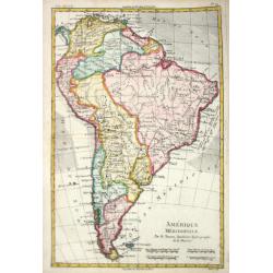
Amérique Méridionale.
Rigobert Bonne (1727-1795), French cartographer. His maps are found in a.o. Atlas Moderne (1762), Raynal's Histoire Philos. du Commerce des Indes (1774) and Atlas Encyclo...
Date: Paris, c. 1770
Selling price: ????
Please login to see price!
Sold
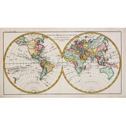
L' Ancien Monde et le Nouveau en deux Hemispheres.
Rigobert Bonne (1727-1795), French cartographer. His maps are found in a.o. Atlas Moderne (1762), Raynal's Histoire Philos. du Commerce des Indes (1774) and Atlas Encyclo...
Date: Paris, c. 1770
Selling price: ????
Please login to see price!
Sold
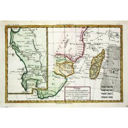
Carte du canal de Mosambique, contenant l' Isle de Madagascar avec les Côtes d' Afrique depuis le Cap de Bonne Esperance jusqu'a Melinde
Rigobert Bonne (1727-1795), French cartographer. His maps are found in a.o. Atlas Moderne (1762), Raynal's Histoire Philos. du Commerce des Indes (1774) and Atlas Encyclo...
Date: Paris, c. 1770
Selling price: ????
Please login to see price!
Sold
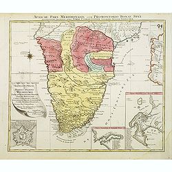
Africae Pars Meridionalis.
There are three detailed insets : the Cape Fort, Saldanda Bay and the Cape of Good Hope, all with a detailed identifying legend.
Date: Augsburg, 1770
Selling price: ????
Please login to see price!
Sold in 2008
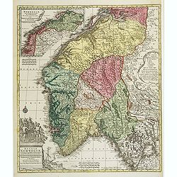
Regnum Norwegiae accurata et novissima delineatione?
Uncommon map of Norway. T.C. Lotter married M. Seutter's daughter in 1740 and succeeded him in 1756. Lotter used the copperplate of Seutter, he only changed the name.
Date: Augsbourg, 1770
Selling price: ????
Please login to see price!
Sold
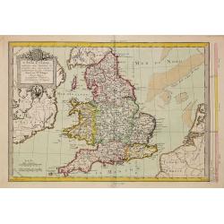
L'Angleterre..
Fine detailed and uncommon map of England. Prepared by Etienne André Philippe de Pretot (1708-1787) a royal censor and professor of history at the Royal Academy of Scien...
Date: Paris, 1770
Selling price: ????
Please login to see price!
Sold in 2011
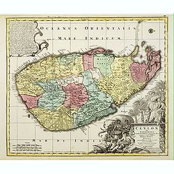
Ceylon olim Taprobana?Maris Indici Insula?
T.C. Lotter married M. Seutter's daughter in 1740 and succeeded him in 1756. Lotter used the copperplate of Seutter, he only changed the name.
Date: Augsbourg, 1770
Selling price: ????
Please login to see price!
Sold
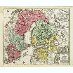
Magni Ducatus Finlandiae?
The map is based on the archetypal map of the Swede Anders Bure. T.C. Lotter married M. Seutter's daughter in 1740 and succeeded him in 1756. Lotter used the copperplate ...
Date: Augsbourg, 1770
Selling price: ????
Please login to see price!
Sold
Nieuwe Kaart van het Westelykste Deel der Weereld.
Izaak Tirion (d. 1769) Amsterdam publisher. His ' Nieuwe en beknopte handatlas' saw 6 editions between before 1740 and after 1784. Also ' Tegenwoordige staat van alle vol...
Date: Amsterdam, c. 1770
Selling price: ????
Please login to see price!
Sold
Nieuwe Kaart van de Eilanden van Groot Brittannien behelzende de Koningryken Engeland, Scotland en ierland.
Izaak Tirion (d. 1769) Amsterdam publisher. His ' Nieuwe en beknopte handatlas' saw 6 editions between before 1740 and after 1784. Also ' Tegenwoordige staat van alle vol...
Date: Amsterdam, c. 1770
Selling price: ????
Please login to see price!
Sold in 2010
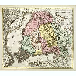
Nova mappa geographica Sueciae ac Gothiae regna ut et Finlandiae Ducatum ac Lapponiam?
Fine map including most of Sweden, Lapland and Finland.T.C. Lotter married M. Seutter's daughter in 1740 and succeeded him in 1756. Lotter used the copperplate of Seutter...
Date: Augsbourg, 1770
Selling price: ????
Please login to see price!
Sold in 2010
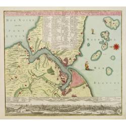
Plan von Constantinopel..
Constantinople and environs with panorama of the city beneath (uncolored), engraved plan of the town with a extensive key of 75 to the most important buildings of the tow...
Date: Augsburg 1770
Selling price: ????
Please login to see price!
Sold
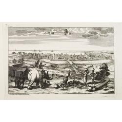
Prospect der Stadt Masulipatam in Ost=Indien.
A rare view of the town of Masulipatam in India. Many locals and elephants in the foreground.
Date: Nurnberg 1770
Selling price: ????
Please login to see price!
Sold