Browse Listings
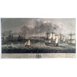
TO S,,r George Pocock KNIGHT of the BATH and Admiral of the Blue Squadron of His Majesty’s Fleet, on the EXPEDITION against the Havannah in 1762, / This PERSPECTIVE VIEW of the Harbour, with the LAND to the West, the MORO CASTLE to
A large, rare view of the British fleet entering the harbor of Havana to take possession of the town, 16 August 1762. Seven Years War (1756-63). Engraved after paintings ...
Date: London, 1766
Selling price: ????
Please login to see price!
Sold in 2021
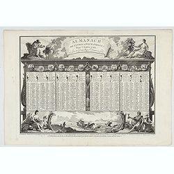
Almanach de l'indicateur fidele pour l'année 1766.
Engraved page of Desnos almanac.
Date: Paris, ca. 1766
Selling price: ????
Please login to see price!
Sold in 2022
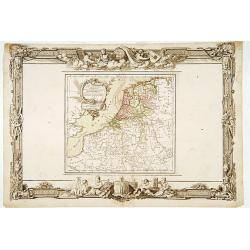
Les Pays-Bas. . .
Beautiful map of the Low Countries placed in a impressive Baroque border with putti using surveying instruments and a celestial globe.
Date: Paris, 1766
Selling price: ????
Please login to see price!
Sold in 2014
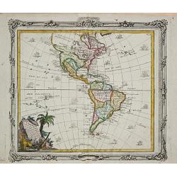
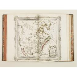
L' Amerique.
Louis Brion de la Tour (1756-1823), ' Atlas Géneral, Civil et Ecclésiastique', 1766, ' Atlas Général', 1790-98. Louis Charles Desnos (fl.1750-70), Le Rouge's 'Atlas N...
Date: Paris, 1766
Selling price: ????
Please login to see price!
Sold
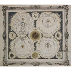
Systêmes de Ptolémée-Copernic- Descartes- Tycho Brahé.
Louis Brion de la Tour (1756-1823), ' Atlas Géneral, Civil et Ecclésiastique', 1766, ' Atlas Général', 1790-98. Louis Charles Desnos (fl.1750-70), Le Rouge's 'Atlas N...
Date: Paris, 1766
Selling price: ????
Please login to see price!
Sold
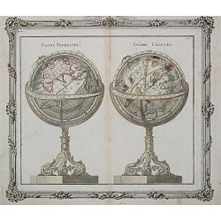
Globes Terrestre / Céleste
A set of a terrestrial and a celestial globe, from the ' Atlas Géneral, Civil et Ecclésiastique'.Louis Brion de la Tour (1756-1823), ' Atlas Géneral, Civil et Ecclési...
Date: Paris, 1766
Selling price: ????
Please login to see price!
Sold
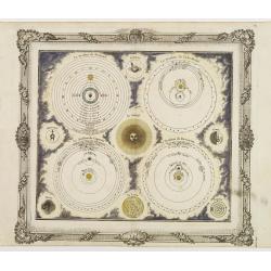
Systêmes de Ptolémée-Copernic- Descartes- Tycho Brahé.
A celestial print from the Atlas Général, Civil et Ecclésiastique with 4 different solar systems. Chart is printed within a decorative border.
Date: Paris 1766
Selling price: ????
Please login to see price!
Sold
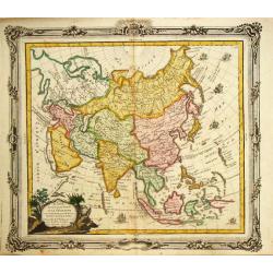
L' Asie.
Louis Brion de la Tour (1756-1823), "Atlas Géneral, Civil et Ecclésiastique", 1766, " Atlas Général", 1790-98. Louis Charles Desnos (fl.1750-70), ...
Date: Paris, 1766
Selling price: ????
Please login to see price!
Sold in 2010
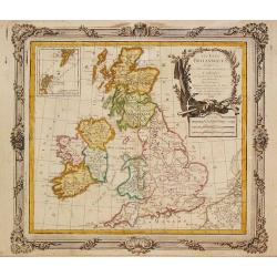
Les Isles Britanniques, 1766. Plus 2 other maps of the area
Les Isles Britanniques, 1766. Plus 2 other maps of the area Louis Brion de la Tour (1756-1823), ' Atlas Géneral, Civil et Ecclésiastique', 1766, ' Atlas Général', 17...
Date: Paris, 1766
Selling price: ????
Please login to see price!
Sold in 2020
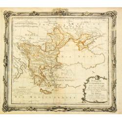
Turquie Europeenne.
Louis Brion de la Tour (1756-1823), ' Atlas Géneral, Civil et Ecclésiastique', 1766, ' Atlas Général', 1790-98. Louis Charles Desnos (fl.1750-70), Le Rouge's 'Atlas N...
Date: Paris, 1766
Selling price: ????
Please login to see price!
Sold in 2017
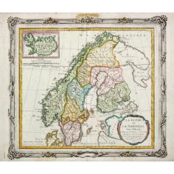
La Suede et La Norwege Avec l' Islande divisee par Provinces et sous deux Metropoles Ecclesiastiques.
Louis Brion de la Tour (1756-1823), ' Atlas Géneral, Civil et Ecclésiastique', 1766, ' Atlas Général', 1790-98. Louis Charles Desnos (fl.1750-70), Le Rouge's 'Atlas N...
Date: Paris, 1766
Selling price: ????
Please login to see price!
Sold
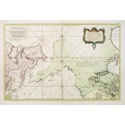
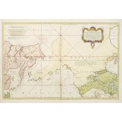
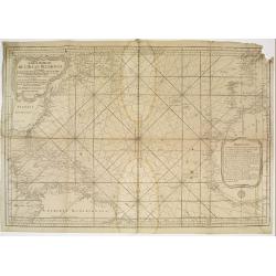
Carte Réduite de L'Ocean Septentrional compris entre l'Asie et l'Amerique.. (1766)
Large and detailed chart prepared by N.Bellin of east coast of Asia and western America, including Alaska, California, and Great Lakes region in the typical Bellin format...
Date: Paris 1766
Selling price: ????
Please login to see price!
Sold
Carte Réduite de L'Ocean Septentrional. . .
A first state, with no page number, price or Depot de la Marine stamp engraved anywhere. Large and detailed map prepared by Bellin of east coast of Asia and western Ameri...
Date: Paris 1766
Selling price: ????
Please login to see price!
Sold
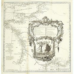
Carte Générale des Côtes de de France.
Index map of the French coasts with superb decorative cartouche depicting the sea landing of a boat.
Date: Paris, 1766
Selling price: ????
Please login to see price!
Sold in 2011
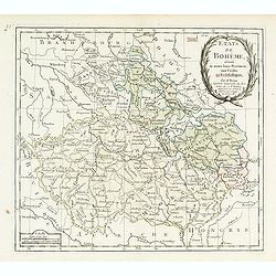
Etats de Bohême divisés..
Detailed map centered on Prague.
Date: Paris, 1766
Selling price: ????
Please login to see price!
Sold
Atlas Ecclésiastique..
Very fine world atlas, each map is set in a fine Rococo border and each map has a charming title cartouche. Most maps are dated 1766 some have an older date.Of particular...
Date: Paris 1766
Selling price: ????
Please login to see price!
Sold
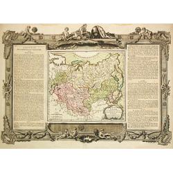
Grande Tartarie et Isles du Japon.
Louis Brion de la Tour (1756-1823), 'Atlas Géneral, Civil et Ecclésiastique', 1766, 'Atlas Général', 1790-98. Louis Charles Desnos (fl.1750-70), Le Rouge's 'Atlas Nou...
Date: Paris, 1766
Selling price: ????
Please login to see price!
Sold
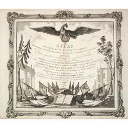
Atlas Général, Civil et Eccléstistique.
Elegantly engraved frontispice.
Date: Paris, 1766
Selling price: ????
Please login to see price!
Sold
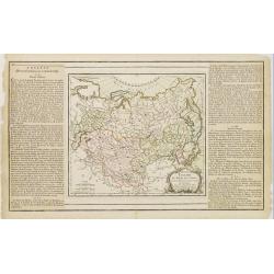
Grande Tartarie et Isles du Japon.
Text on both sides. Curious shape for Japan, but Ieso as an island and on the position of Hokaido.Curious shape for Korea.
Date: Paris 1766
Selling price: ????
Please login to see price!
Sold in 2009
Carte Reduite de l'Ocean Occidental.
Superb sea chart of the Atlantic Ocean by Jacques Nicolas Bellin (1703-1772) the Royal Hydrographer and head of the Depot de la Marine, in Paris.The chart is filled with ...
Date: Paris 1766
Selling price: ????
Please login to see price!
Sold
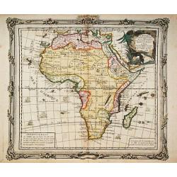
L' Afrique.
Louis Brion de la Tour (1756-1823), ' Atlas Géneral, Civil et Ecclésiastique', 1766, ' Atlas Général', 1790-98. Louis Charles Desnos (fl.1750-70), Le Rouge's 'Atlas N...
Date: Paris, 1766
Selling price: ????
Please login to see price!
Sold in 2016
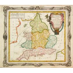
L' Angleterre divises en 5 grandes Parties subsidivisees en 52 Comtes et partagee en 2 Provinces Ecclesiastiques.
Louis Brion de la Tour (1756-1823), ' Atlas Géneral, Civil et Ecclésiastique', 1766, ' Atlas Général', 1790-98. Louis Charles Desnos (fl.1750-70), Le Rouge's 'Atlas N...
Date: Paris, 1766
Selling price: ????
Please login to see price!
Sold in 2018
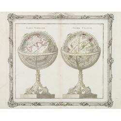
Globe Terestre - Globe Céléste.
A decorative copper plate of a large pair of globes on ornate rococo-style bases. The Globe Terrestre is centered on the Eastern Hemisphere. The Globe Celeste is showing ...
Date: Paris, 1766
Selling price: ????
Please login to see price!
Sold in 2008
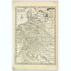
![[No title] Carte générale d'Allemagne divisée et numérotée...des postes et autres routes de cet empire.](/uploads/cache/29330-250x250.jpg)
[No title] Carte générale d'Allemagne divisée et numérotée...des postes et autres routes de cet empire.
Map of Istria, part of Austria and Hungary.A so called post road mapspost route map.Desnos, born in a small village close to Beauvais, was apprenticed to Joseph-Simon Gui...
Date: Paris, 1766
Selling price: ????
Please login to see price!
Sold in 2011
![[No title] Carte générale d'Allemagne divisée et numérotée...des postes et autres routes de cet empire.](/uploads/cache/29261-250x250.jpg)
[No title] Carte générale d'Allemagne divisée et numérotée...des postes et autres routes de cet empire.
Map of Switzerland and part of south west Germany and Lake Como, including the postal roads until Milan and Turin.A so called post road mapspost route map.Desnos, born in...
Date: Paris, 1766
Selling price: ????
Please login to see price!
Sold in 2011
![[No title] Carte générale d'Allemagne divisée et numérotée...des postes et autres routes de cet empire.](/uploads/cache/29260-250x250.jpg)
[No title] Carte générale d'Allemagne divisée et numérotée...des postes et autres routes de cet empire.
Map centered on Czechoslovakia, with Prague, including, Krakow, Vienna, Leipzig, etc.A so called post road mapspost route map.Desnos, born in a small village close to Bea...
Date: Paris, 1766
Selling price: ????
Please login to see price!
Sold in 2011
![[No title] Carte générale d'Allemagne divisée et numérotée...des postes et autres routes de cet empire.](/uploads/cache/29259-250x250.jpg)
[No title] Carte générale d'Allemagne divisée et numérotée...des postes et autres routes de cet empire.
Map representing western part of Germany and Belgium.A so called post road mapspost route map.Desnos, born in a small village close to Beauvais, was apprenticed to Joseph...
Date: Paris, 1766
Selling price: ????
Please login to see price!
Sold in 2011
![[No title] Carte générale d'Allemagne divisée et numérotée...des postes et autres routes de cet empire.](/uploads/cache/29258-250x250.jpg)
[No title] Carte générale d'Allemagne divisée et numérotée...des postes et autres routes de cet empire.
Map representing a northern part of Germany, with the province of Saxen the western part of Poland. A so called post road mapspost route map.Desnos, born in a small villa...
Date: Paris, 1766
Selling price: ????
Please login to see price!
Sold in 2015
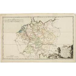
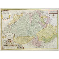
Carte générale d'Allemagne divisée et numérotée...des postes et autres routes de cet empire.
Map of Germany and neighboring countries.A so called post road mapspost route map.Desnos, born in a small village close to Beauvais, was apprenticed to Joseph-Simon Guibo...
Date: Paris, 1766
Selling price: ????
Please login to see price!
Sold in 2011
Les Suisses leurs sujets et leurs alliez. . .
Un uncommon later edition of De Fer's map of Switzerland, now updated and corrected by his successor, Louis Charles Desnos. In the lower left corner thirteen coats of arm...
Date: Paris , ca. 1766
Selling price: ????
Please login to see price!
Sold in 2011
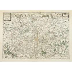
Nouv.lle Election et Environs de Paris très détaillés. . .
Charming small map centered on Paris, depicting a large area around the capital. Small title cartouche and scale cartouche in the upper corners.From the second edition of...
Date: Paris, 1766
Selling price: ????
Please login to see price!
Sold
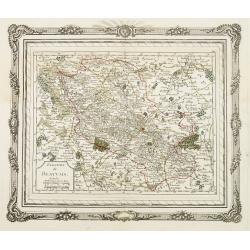
Election de Beauvais.
Charming small map depicting the area around Beauvais. Surrounded by a decorative frame embellished with floral patterns. From the second edition of the rare Atlas chorog...
Date: Paris, 1766
Selling price: ????
Please login to see price!
Sold
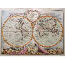
Mappe Monde Carte Universelle De La Terre Dressee Sure les Nouvelles Observations de Mrs. De L'Academie Royael Des Sciences.
Rare and fascinating double hemisphere map of the World. Includes a massive "Mer de l'Ouest" in the Northwest of North America. Further with text in French such...
Date: Paris, 1766
Selling price: ????
Please login to see price!
Sold in 2014
![[No tittle]](/uploads/cache/29446-250x250.jpg)
[No tittle]
Map of Czech Republic and Hungary.
Date: Paris, 1766
Selling price: ????
Please login to see price!
Sold in 2014
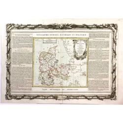
Le Danemark Divise par Provinces et Dioceses Sous une Metropole.
A very decorative map of Denmark, colored by its Provinces. From Brion's atlas, with elaborate decorative border - which was separately printed from the actual map. The s...
Date: Paris, 1766
Selling price: ????
Please login to see price!
Sold in 2016
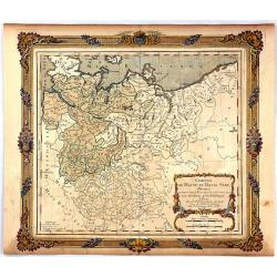
Cercles de Haute et Basse Saxe...
A decorative map of northern Germany with a fine title cartouche. The map is surrounded by a wide rococo-style frame. The map and decorative border were printed from two ...
Date: Paris, 1766
Selling price: ????
Please login to see price!
Sold in 2016
![KLAIPEDA, Lithuania: [Regni Borussiae Episcopatus Warmiensis Palatinatus Mariaeburgensis] et Culmensis cum Territorio Dantiscano et Ichnographia Urbis. . .](/uploads/cache/37064-250x250.jpg)
KLAIPEDA, Lithuania: [Regni Borussiae Episcopatus Warmiensis Palatinatus Mariaeburgensis] et Culmensis cum Territorio Dantiscano et Ichnographia Urbis. . .
Second plate of a rare wall map, shows the territory around Klaipeda (Memel) in Lithuania. Between 1701–1871 the area belonged to the Kingdom of Prussia. This wall map ...
Date: Berlin, Preussische Akademie der Wissenschaften 1763-1766
Selling price: ????
Please login to see price!
Sold in 2016
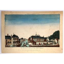
Vue du Canal de Delfi a la Haye Ville de Hollande.
A hand colored optical print published in Paris by Jacques Chereau in about 1770. During the 18th century there were several manufacturers of optical viewing devices and ...
Date: Paris, 1766
Selling price: ????
Please login to see price!
Sold in 2019
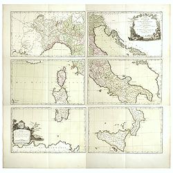
Carte d'Italie, assujettie aux observations astronomiques et aux itinéraires. Comprenant toutes les grandes routes qui traversent les différens Etat de cette région . . .
Six double page original hand-colored engraved post road maps maps of Italy, from the 'Nouvel itinéraire général' by Louis Desnos, marking the major roads. In upper ri...
Date: Paris, 1766
Selling price: ????
Please login to see price!
Sold in 2023
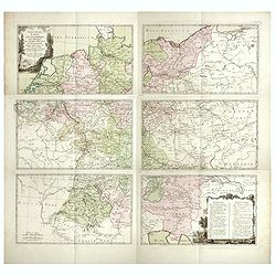
Nouvelle carte géographique des postes et autres routes d'Allemage,
Six double page original hand-colored engraved post road maps maps of Germany, Low Countries, Poland and Austria. A decorative cartouche is on the upper left corner and a...
Date: Paris, 1766
Selling price: ????
Please login to see price!
Sold in 2019
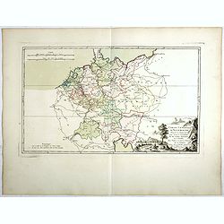
Carte Génerale d'Allemagne, Divisée et Numerotée pour servir à l'assemblage de la Carte Suivante . . .
Double page original hand-colored engraved keymap of the six sheet post road maps map of Germany, Low Countries, Poland and Austria. A decorative cartouche is on the lowe...
Date: Paris, 1766
Selling price: ????
Please login to see price!
Sold in 2019
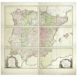
Carte d'Espagne et de Portugal, comprenant les routes des postes et autres de ces deux roiaumes.? . .
Six double page original hand-colored engraved post road maps maps of Spain and Portugal. A decorative cartouche is on the lower left corner and a decorative map legend i...
Date: Paris, 1766
Selling price: ????
Please login to see price!
Sold in 2017
![[North America].](/uploads/cache/39534-250x250.jpg)
[North America].
Two sheets (nos 1 & 3) of a larger 4 sheet wall map of North America, published by Postlethwayt, from his "Dictionary of Trade and Commerce".The work is bas...
Date: [London], ca. 1766
Selling price: ????
Please login to see price!
Sold in 2017
Regni Borussiae Episcopatus Warmiensis Palatinatus Mariaeburgensis et Culmensis cum Territorio Dantiscano et Ichnographia Urbis Regiomontis.
Very rare and important wall map in 6 sheets of Prussia, dissected and mounted on canvas, each map with printed label of the Paris map seller Charles Piquet. Each label w...
Date: Berlin, Preussische Akademie der Wissenschaften, 1763-1766
Selling price: ????
Please login to see price!
Sold in 2017
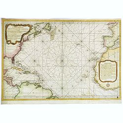
Carte Reduite de l'Ocean Occidental. . .
An attractive mid eighteenth century sea chart published in Paris by Jacques Nicolas Bellin. The chart shows from the north of South America, northwards to the Caribbean,...
Date: Paris, ca 1766
Selling price: ????
Please login to see price!
Sold in 2020
A New & Accurate Map of Germany, divided into its Circles. . .
An attractive map of Germany by the Englishman Emanuel Bowen. With plenty of good map detail, and set off with a decorative title cartouche in upper right corner.Shows fr...
Date: London, ca 1766
Selling price: ????
Please login to see price!
Sold in 2021

L' Empire Des Turcs.
A highly detailed map of the Arabian Peninsula and the Eastern Mediterranean Sea.
Date: Paris, 1767
Selling price: ????
Please login to see price!
Sold in 2020

Le Royaume de Pologne. . .
Detailed map of Poland, including Lithuania, Ukraine, East Prussia, etc. Decorative title cartouche at the top left corner. Explication table along the right lateral side...
Date: Paris, 1767
Selling price: ????
Please login to see price!
Sold in 2013
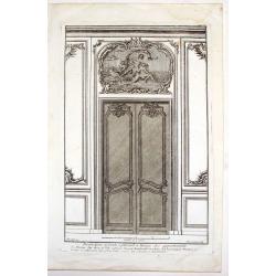
Decoration de Porte a Placard a Lusage des Appartements.
Fine copper engraving from "Livre Nouveau ou Regles des Cinq Orders d'Architecture" by Jaques Barozzio (giacomo Barozzi de Vignole). François-Philippe Charp...
Date: Paris, 1767
Selling price: ????
Please login to see price!
Sold in 2013

Chandelier Pascal, Montant avec Suspensoir de la Planche, Lutrin, Appui de Communion.
Fine copper engraving from "Livre Nouveau ou Regles des Cinq Orders d'Architecture" by Jaques Barozzio (giacomo Barozzi de Vignole).François-Philippe Charpenti...
Date: Paris, 1767
Selling price: ????
Please login to see price!
Sold in 2015
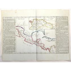
Du Mexique.
Interesting map of the lakes, rivers and mountains of Mexico. With inset of "LA TERRE FIRME". The history of the region is featured to the sides. Published by M...
Date: Paris, 1767
Selling price: ????
Please login to see price!
Sold in 2015
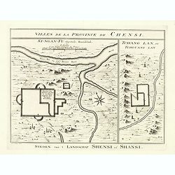
Villes de la Province de Chensi. Steden van't Landschap Shensi of Shansi.
Interesting set of two local town plans of "Si-Ngan-Fu: Capitale, Hoofdstad." and "Tchang Lan, Ou Tchouang Lan.", both cities in the province of Shanx...
Date: The Hague, Pieter de Hondt, 1747-1767
Selling price: ????
Please login to see price!
Sold in 2022
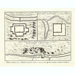
Tchin-Ywen-Fou (...). Chin-Ywen-Fu, (...), in't Landschap Quey-Chew, of Koei-Tcheou.
Interesting set of three local town plans each with extensive titles : "Lan-Tcheou ou Lan-Chew Dans la Province Chensi (…). Lan-Chew, of Lan-Tcheou, in't Landschap...
Date: The Hague, Pieter de Hondt, 1747-1767
Selling price: ????
Please login to see price!
Sold in 2022
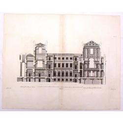
Section of the Mansion House - Vitruvius Britannicus.
Fine architectural copper engraving of a section of the Manor House in London, the front with columns and portico on the left and the inside of the rooms shown on the two...
Date: London, 1767
Selling price: ????
Please login to see price!
Sold in 2019
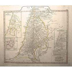
La Palestine.
This is an authentic Antique Map of Palestine by Jean Baptiste d’Anville. The map was published out of Paris in 1767.This informative map shows the area of Palestine an...
Date: Paris, 1767
Selling price: ????
Please login to see price!
Sold in 2015
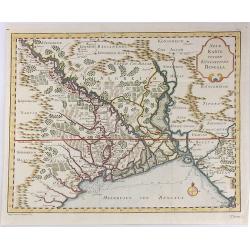
Neue Karte Von De, Konigreiche Bengala.
A fine Jacques Bellin map of the Nyanmar region of India, featuring the Bay of Bengal.
Date: Paris, 1767
Selling price: ????
Please login to see price!
Sold in 2017
‘Somersetshire Divided into Hundreds'
An extremely rare map from Emanuel Bowen’s 'Atlas Anglicanus.'The maps for the Atlas Anglicanus were first issued in monthly parts, between 1767 and 1768, before the co...
Date: London, 1767
Selling price: ????
Please login to see price!
Sold in 2020
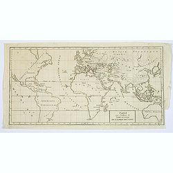
Carte pour l'intelligence du Livre Institule de L'Espirit des Loix.
A supplementary World map by R. de Vaugondy, included in the multivolume work by Baron de Montesquieu "The Spirit of the Laws." Box title, Tasmania is still par...
Date: Paris, ca. 1767
Selling price: ????
Please login to see price!
Sold in 2023
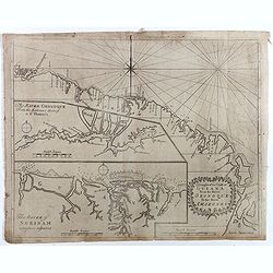
A Large Draught of New England New York and Long Island.
Two charts on one sheet showing the New England coast. The chart displayed here focuses on the New England coast from the Hudson River to the Penobscot River.Grierson pub...
Date: Dublin, 1767
Selling price: ????
Please login to see price!
Sold in 2017
A Draught of the Coast of GUIANA From the River Oronoque To the River Amazones.
Rare chart with the coastline of the Guyana's with small insets of two charts of The River Oronoque from the entrance to St. Thomas's and The River of Surinam. Compass po...
Date: Dublin, 1767
Selling price: ????
Please login to see price!
Sold in 2017
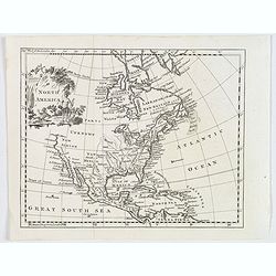
North America.
A nice general map of North America, published in London during the latter half of the eighteenth century. It mentions many Native American Indian Tribes, shows 'New Albi...
Date: London, 1767
Selling price: ????
Please login to see price!
Sold in 2019

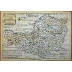
Basse Saxe.
A map of the northwestern German region of Lower Saxony. A map of French origin, published in the late eighteenth or early nineteenth centuries, has informative and inter...
Date: Paris, ca. 1767
Selling price: ????
Please login to see price!
Sold in 2021
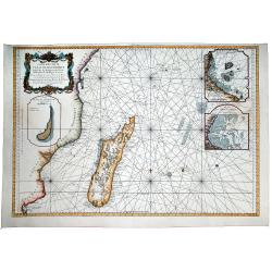
Carte Reduite de CANAL DE MOZAMBIQUE et des Isles de Madagascar de France de Bourbon, de Rodrigues et autres. Dressee au Depost des Cartes et Plans de Marine Pour Servir aux Vaisseau du Roy . . .
A beautiful large sea chart of the Mozambique Channel, published by the French Hydrographical Department. It includes a detailed treatment of Madagascar and the contiguo...
Date: Paris, 1767
Selling price: ????
Please login to see price!
Sold in 2020
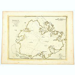
Antigue une des Antilles aux Anglois.
A map of Antigua in the Caribbean published in Paris by Jean Baptist Crepy in the mid eighteenth century. The map shows roads criss-crossing the island, with parishes, vi...
Date: Paris, 1767
Selling price: ????
Please login to see price!
Sold in 2023
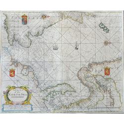
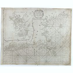
A Chart of the North Sea
Very rare sea-chart after Thornton by George Grierson. Scotish born George Grierson was one of the most important publishers, editors and mapmakers in 18th-century Irela...
Date: Dublin, c1767
Selling price: ????
Please login to see price!
Sold in 2023
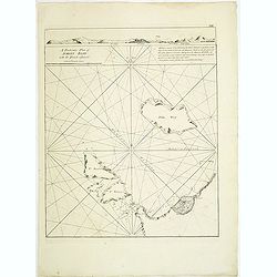
![The Coast of New Found Land From Salmon Cove to Cape Bonavista. . . [together with] The Coast of New Found Land from Cape-Raze to Cape St-Francis.](/uploads/cache/40658-250x250.jpg)
The Coast of New Found Land From Salmon Cove to Cape Bonavista. . . [together with] The Coast of New Found Land from Cape-Raze to Cape St-Francis.
Two charts showing the coast of New Found Land from Salmon Cove to Cape Bonavista and from Cape-Raze to Cape St-Francis. With inset chart of Trinity HarborGrierson publis...
Date: Dublin, 1767
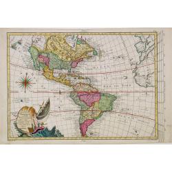
Carte Nouvelle d'Amerique..
Fine map of north and south America, engraved by J.E.T. Vallet and prepared by M.A.Moithey. In western part of North America a large "Mer de L' Quest" or Sea of...
Date: Paris 1767
Selling price: ????
Please login to see price!
Sold
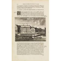
s'Lants en Oost-Indische Lynbanen.
A decorative print of an V.O.C. ware house of rope- and related products. From J.Wagenaar: Amsterdam in zijne opkomst, aanwas, geschiedenisse, enz.
Date: Amsterdam 1760-1767
Selling price: ????
Please login to see price!
Sold
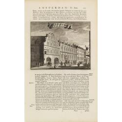
t'Oost-Indisch-Huys.
A decorative print of the East Indian House, the headquarters of the V.O.C., a place for meeting, trading and storage of spices and ship equipment. The maps and charts we...
Date: Amsterdam 1760-1767
Selling price: ????
Please login to see price!
Sold
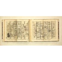
Kitchin's post-Chaise Companion through England and Wales.
large 8vo, oblong, 8 p., hlf. vellum (modern), 104 uncol. maps (15.5 x 20.4 cm), excellent condition.A fine copy of this popular pocket atlas with index, a general map of...
Date: London, R. Sayer / J.Bower / C.Bowles, 1767
Selling price: ????
Please login to see price!
Sold
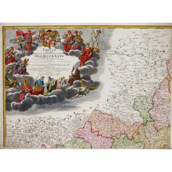
Tabula Almae Dioecesis Amplissimi Episcopatus Olomucensis.
Homann Heirs (of Johann Baptist and Johann Christof) published: Grosser Atlas, 1731, 1737. Geogr. Maior, 1759, Atlas Homannianus, 1762.An attractive, large and very detai...
Date: Nürnberg, 1767
Selling price: ????
Please login to see price!
Sold
![[Title page] Atlas Nouveau portatif à l'Usage des Militaires College et du Voyageur. Tome Ier . . .](/uploads/cache/25261-250x250.jpg)
[Title page] Atlas Nouveau portatif à l'Usage des Militaires College et du Voyageur. Tome Ier . . .
A decorative title page, showing winged puttee presenting four volumes to a reclining female figure on a rock. Other decoration includes a sailing vessel with somebody us...
Date: Paris, 1767
Selling price: ????
Please login to see price!
Sold in 2008
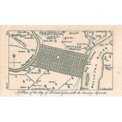
A Plan of the City of Philadelphia, with the Country Adjacent.
Early small plan of Philadelphia, published in "The World displayed; or, a curious collection of voyages and travels...". Quite detailed with roads and houses...
Date: London, 1767
Selling price: ????
Please login to see price!
Sold in 2010
![[Title page] Atlas Nouveau portatif à l'Usage des Militaires College et du Voyageur. Tome Ier . . .](/uploads/cache/31057-250x250.jpg)
[Title page] Atlas Nouveau portatif à l'Usage des Militaires College et du Voyageur. Tome Ier . . .
A decorative title page, showing winged puttee presenting four volumes to a reclining female figure on a rock. Other decoration includes a sailing vessel with somebody us...
Date: Paris, 1767
Selling price: ????
Please login to see price!
Sold in 2015
A particular plan of Acheen road with the islands adjacent. . .
Uncommon English of part of the most northern part of Sumatra, with the ancient Sultanate of Acheen.William Herbert (1718-1795), was born 29 Nov. 1718, and was educated ...
Date: London, 1767
Selling price: ????
Please login to see price!
Sold in 2011
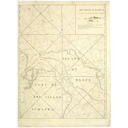
The straits of Banca. . .
Uncommon English with the Straits of Banca in northern part of Sumatra, with inset map in top right corner.William Herbert (1718-1795), was born 29 Nov. 1718, and was ed...
Date: London, 1767
Selling price: ????
Please login to see price!
Sold in 2011
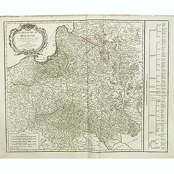
Le Royaume de Pologne. . .
Detailed map of Poland, including Lithuania, Ukraine, East Prussia, etc. Decorative title cartouche at top left corner. Explication table along right lateral side of the ...
Date: Paris, Delamarche, 1767
Selling price: ????
Please login to see price!
Sold in 2015
Atlas.
Charming atlas published by Pieter Meijer of Amsterdam. Meijer gives credit on all of his maps to E.Bowen.Including a double hemisphere world map and maps of America, Afr...
Date: Amsterdam, 1768
Selling price: ????
Please login to see price!
Sold
![[Title page] Cosmographie Universelle, Physique et Astronomique, pour l'étude de touts les âges de l'histoire ..](/uploads/cache/17250-250x250.jpg)
[Title page] Cosmographie Universelle, Physique et Astronomique, pour l'étude de touts les âges de l'histoire ..
Uncommon title page from atlas by Etienne André Philippe de Pretot (1708-1787, a royal censor and professor of history at the Royal Academy of Science in Paris.
Date: Paris, 1768
Selling price: ????
Please login to see price!
Sold
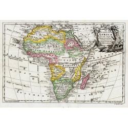
An Accurate Map of Africa..
An Accurate Map of Africa from the Latest Improvements A nice copperplate engraved map from Edward Cavendish Drake's "A new Universal Collection of Authentic and Ent...
Date: London, 1768
Selling price: ????
Please login to see price!
Sold

