Browse Listings
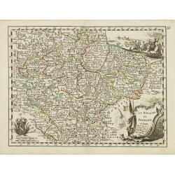
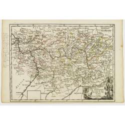
Le Royaume de Boheme.
Fine map of Bohemia, with title cartouche and two decorative cartouches on upper right and lower left corners. George Louis Le Rouge was active from 1740- till 1780 as a ...
Date: Paris 1756
Selling price: ????
Please login to see price!
Sold
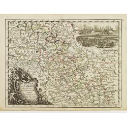
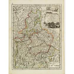
Le Duché de Silesie..
Fine map of Silesia. With title cartouche and decorative cartouche on upper right corner. George Louis Le Rouge was active from 1740- till 1780 as a publisher, and was ap...
Date: Paris 1756
Selling price: ????
Please login to see price!
Sold
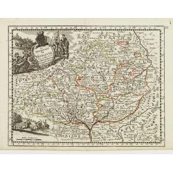
Le Royaume de Hongrie.
Fine map of Hungary, with title cartouche. With title cartouche and decorative cartouche on upper right corner. George Louis Le Rouge was active from 1740- till 1780 as a...
Date: Paris 1756
Selling price: ????
Please login to see price!
Sold
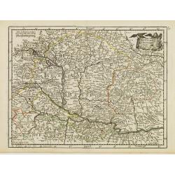
Le Marquisat de Moravie.
Fine map of Moravia, with decorative title cartouche and another cartouche on lower left corner. George Louis Le Rouge was active from 1740- till 1780 as a publisher, and...
Date: Paris 1756
Selling price: ????
Please login to see price!
Sold
La Baviere..
Fine map of Bavaria, with decorative title cartouche. George Louis Le Rouge was active from 1740- till 1780 as a publisher, and was appointed engineer for the King of Fra...
Date: Paris 1756
Selling price: ????
Please login to see price!
Sold
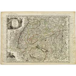
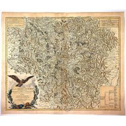
La Souabe.
Fine map of Schwaben, with decorative title cartouche and another cartouche in lower left corner. With manuscript notes in top, left and right margins giving some histori...
Date: Paris 1756
Selling price: ????
Please login to see price!
Sold in 2021
Cercle de la Haute Saxe.
Fine map of Saxony, with decorative title cartouche. George Louis Le Rouge was active from 1740- till 1780 as a publisher, and was appointed engineer for the King of Fran...
Date: Paris 1756
Selling price: ????
Please login to see price!
Sold in 2018
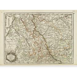
L'Electorat de Cologne, Le Duché de Bergue et Juliers.
Fine map of the south-eastern part of North Rhine-Westphalia, around Düsseldorf and Cologne. With decorative title cartouche. George Louis Le Rouge was active from 1740 ...
Date: Paris 1756
Selling price: ????
Please login to see price!
Sold in 2020
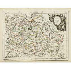
La Franconie.
Fine map of the German region Baden-Württemberg, with decorative title cartouche. With manuscript notes in left margin giving some historical information about the regio...
Date: Paris 1756
Selling price: ????
Please login to see price!
Sold in 2020
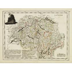
La Suisse.
Fine map of Switzerland with dark decorative cartouche on upper left corner. With date 1743 added in manuscript.George Louis Le Rouge was active from 1740- till 1780 as a...
Date: Paris 1756
Selling price: ????
Please login to see price!
Sold in 2009
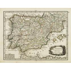
L' Espagne Suivant les Nouvelles Observations.
Fine map of Spain and Portugal with decorative title cartouche. With date 1743 added in manuscript.George Louis Le Rouge was active from 1740- till 1780 as a publisher, a...
Date: Paris 1756
Selling price: ????
Please login to see price!
Sold
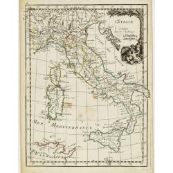
L' Italie.
Fine map of Italy with decorative title cartouche. With date 1743 added in manuscript.George Louis Le Rouge was active from 1740- till 1780 as a publisher, and was appoin...
Date: Paris, 1756
Selling price: ????
Please login to see price!
Sold in 2020
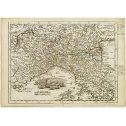
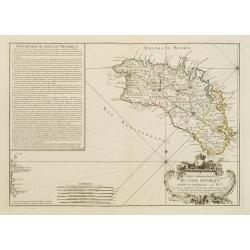
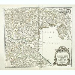
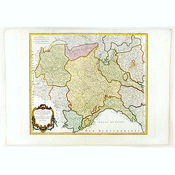
La Lombardie, Le Cours du Po &c Le Duché de Toscane.
Fine map of northern Italy with decorative cartouche illustrating some vessels in the gulf of Genoa. With manuscript notes in right margin giving some historical informat...
Date: Paris 1756
Selling price: ????
Please login to see price!
Sold
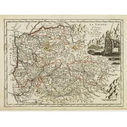
La Savoye.
Fine map of Savoy with decorative cartouches on right corners. George Louis Le Rouge was active from 1740- till 1780 as a publisher, and was appointed engineer for the Ki...
Date: Paris 1756
Selling price: ????
Please login to see price!
Sold
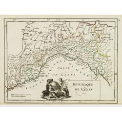
République de Gênes.
Fine map of the gulf of Genoa. With decorative title cartouche. With date 1749 added in manuscript.George Louis Le Rouge was active from 1740- till 1780 as a publisher, a...
Date: Paris 1756
Selling price: ????
Please login to see price!
Sold
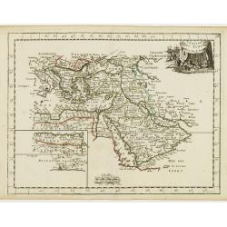
L' Empire des Turcs.
Fine map of the Ottoman Empire. Presenting a decorative title cartouche and an inset illustrating the western part of Magreb. George Louis Le Rouge was active from 1740- ...
Date: Paris 1756
Selling price: ????
Please login to see price!
Sold
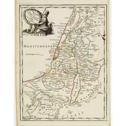
La Palestine ou la Terre Sainte divisée en dix Tribus..
Fine map of Palestine with ten tribal territories outlined in color. A helmeted female figure holds the garlanded title cartouche.George Louis Le Rouge was active from 17...
Date: Paris 1756
Selling price: ????
Please login to see price!
Sold
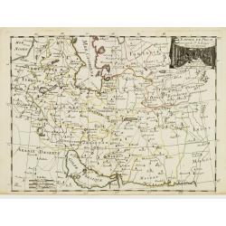
L'Empire de Perse.
Fine map of Persia. With decorative title cartouche. George Louis Le Rouge was active from 1740- till 1780 as a publisher, and was appointed engineer for the King of Fran...
Date: Paris 1756
Selling price: ????
Please login to see price!
Sold
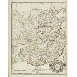
La Chine.
Fine map of China, with in lower right corner Taiwan and a large decorative title cartouche. George Louis Le Rouge was active from 1740- till 1780 as a publisher, and was...
Date: Paris, 1756
Selling price: ????
Please login to see price!
Sold
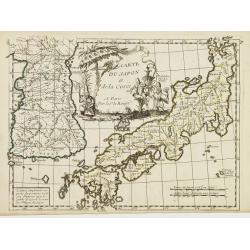
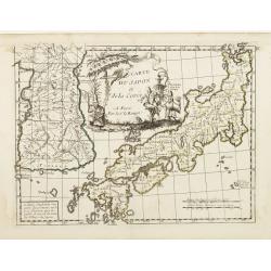
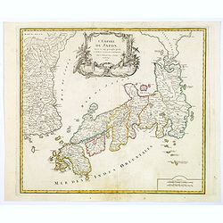
Carte du Japon et de la Corée.
Neat map of Japan, less Hokkaido but including the Korean peninsula, with a large figured cartouche at top center. A note reads to the effect that Le Rouge has simplified...
Date: Paris, 1756
Selling price: ????
Please login to see price!
Sold in 2008
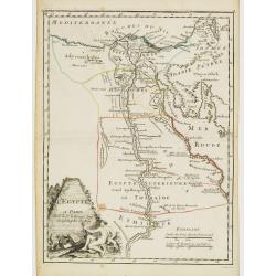
L'Egypte.
Fine map of Egypt. With decorative title cartouche. George Louis Le Rouge was active from 1740- till 1780 as a publisher, and was appointed engineer for the King of Franc...
Date: Paris, 1756
Selling price: ????
Please login to see price!
Sold in 2011
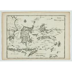
Isles Moluques.
A scarce little map depicting European knowledge of Sulawesi, part of Borneo and the Spice Islands at the time of publication.George Louis Le Rouge was active from 1740- ...
Date: Paris, 1756
Selling price: ????
Please login to see price!
Sold in 2009
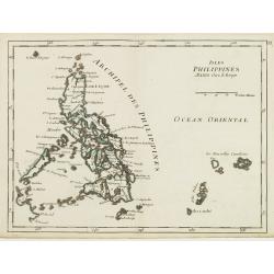
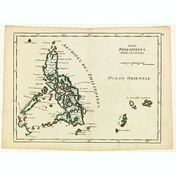
Isles Philippines.
Fine map of the Philippines. George Louis Le Rouge was active from 1740- till 1780 as a publisher, and was appointed engineer for the King of France. From his Atlas Nouve...
Date: Paris, 1756
Selling price: ????
Please login to see price!
Sold in 2015
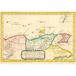
Carte des Provinces des Caracas, Comana et Paria.
Jaques Nicolas Bellin (1702-720) was the most important French hydrographer of the 18th century. Sea-atlas 'Hydrographique Français' , 1756-65, atlas to accompany Prévo...
Date: Paris, c. 1756
Selling price: ????
Please login to see price!
Sold in 2009
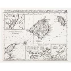
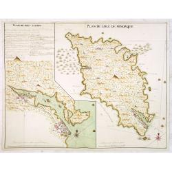
Carte topographique DE L'ISLE MINORQUE, Dédiée et présentée au Roy ..
Very rare map depicting the island of Minorca. The bottom is decorated with a stunning title cartouche, engraved by Choffard.The French text on the left side contains a l...
Date: Paris 1756
Selling price: ????
Please login to see price!
Sold
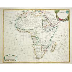
Afrique dresse sur les relation le plus recentes.
Gilles Robert de Vaugondy (!686-1766) and son Didier (1723-86), Paris geographers and publishers. Gilles succeedded Pierre Moulart Sanson in 1730. ' Atlas Portatif', 1748...
Date: Paris, 1756
Selling price: ????
Please login to see price!
Sold in 2017
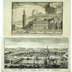
Veduta della Citta di Siviglia../ ..Eglise de Seville.
Fine panoramic view of the Sevillia. Taken from Storia moderna di tutti I popoli del mondo , edited by Thomas Salmon. A italian edition of this famous work, published in ...
Date: Venice 1740-1756
Selling price: ????
Please login to see price!
Sold
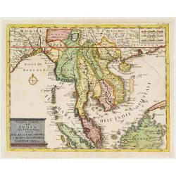
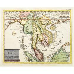
Nuova carte dell' India di là del Fiume Ganges overo di Malacca Siam Cambodia Chiampa KoChinchina Laos Pegu ava&c.
Fine map of Malay Peninsular, with present-day Thailand, taken from Storia moderna di tutti I popoli del mondo , edited by Thomas Salmon. A Italian edition of this famous...
Date: Venice 1740-1756
Selling price: ????
Please login to see price!
Sold
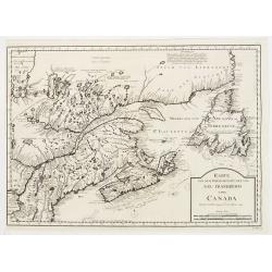
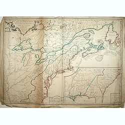
Karte von dem Ostlichen-Stucke von Neu Frankreich oder Canada..
The German edition after Bellin's map that served as the basis for numerous maps to follow. Includes eastern Canada and Newfoundland including Nova Scotia (Arcadia) and P...
Date: Leipzig 1756
Selling price: ????
Please login to see price!
Sold
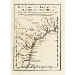
Karte von den Küsten des Französischen Florida..
An attractive map of the coast from Cape Fear, North Carolina, to St. Augustine, Florida. This is a German adaptation of a Bellin map, identifying rivers and major towns....
Date: Leipzig 1756
Selling price: ????
Please login to see price!
Sold
Carte welche die Inseln Maiorca, Minorca, Yvica und Formentera..
So called "Einblattdruck" of Majorca, Minorca and 2 insets of parts of the Island Majorca. Prepared after Felßecker and Bellin.
Date: Frankfurt a.Main & Leipzig, dated 1756
Selling price: ????
Please login to see price!
Sold
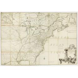
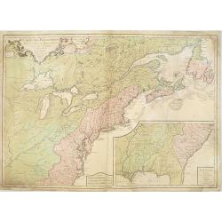
Amerique Septentrionale avec les Routes, Distances en miles, Limites et Etablissements François et Anglois Par le Docteur Mitchel Traduit de 'Anglois..
First French edition of the famous John Mitchell map of the British and French Dominions in North America. Includes the word Limites in the title rather than Villages whi...
Date: Paris 1756
Selling price: ????
Please login to see price!
Sold
Carte du Japon et de la Corée.
Neat map of Japan, less Hokkaido but including the Korean peninsula, with a large figured cartouche at top centre. A note reads to the effect that Le Rouge has simplified...
Date: Paris 1756
Selling price: ????
Please login to see price!
Sold in 2008
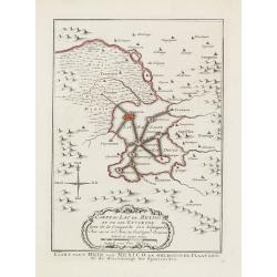
Carte du Lac de Mexico et de ses Environs.
Uncommon edition of this accurate map showing Mexico City and surrounding areas, the ranges and villages of numerous Indian tribes are shown.FromAtlas Portatif pour servi...
Date: Amsterdam, 1756
Selling price: ????
Please login to see price!
Sold
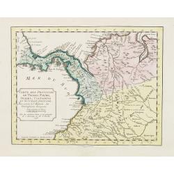
Carte des Provinces de Tierra Firme Darien Cartagene ..
Uncommon edition of this accurate map showing covering Panama and Colombia, the ranges and villages of numerous Indian tribes are shown.FromAtlas Portatif pour servir a l...
Date: Amsterdam, 1756
Selling price: ????
Please login to see price!
Sold in 2008
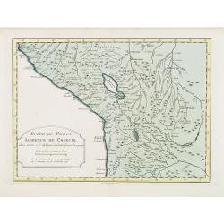
Suite de Perou Audience de Charcas.
Uncommon edition of this accurate map showing the southern Peruvian coast, the ranges and villages of numerous Indian tribes are shown.FromAtlas Portatif pour servir a l'...
Date: Amsterdam, 1756
Selling price: ????
Please login to see price!
Sold in 2020
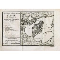
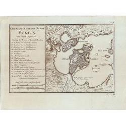
Grundriss von der Stadt Boston und ihren Gegenden
Rare German edition of this detailed plan of the city of Boston with its harbour and surrounding area. Indicates principal buildings such as the various forts and their a...
Date: Paris, c1756
Selling price: ????
Please login to see price!
Sold in 2008
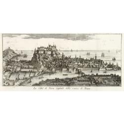
La Citta di Nizza Capitale della Contea di Nizza.
Fine panoramic views of Nice, taken from Storia moderna di tutti I popoli del mondo , edited by Thomas Salmon. A Italian edition of this famous work, published in 26 volu...
Date: Venice, 1740-1756
Selling price: ????
Please login to see price!
Sold in 2011
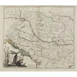
Le Royaume de Hongrie la Transilvanie L'Esclavonie la Croatie et la Bosnie.
Fine map of Hungary with a splendid cartouche of an elephant, a crocodile and a canon and canon balls in the forefront and an array of flags amidst a cloud of smoke in th...
Date: Paris, 1756
Selling price: ????
Please login to see price!
Sold in 2013
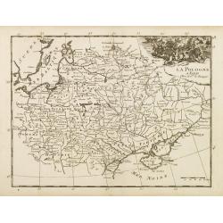
La Pologne.
Fine map of Poland. George Louis Le Rouge was active from 1740- till 1780 as a publisher, and was appointed engineer for the King of France.From his Atlas Nouveau Portati...
Date: Paris, 1756
Selling price: ????
Please login to see price!
Sold in 2008
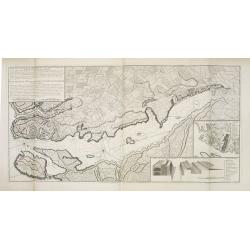
Baye et Port de Boston. Tire des Manuscrits de M. le Chevalier de la Rigaudiere Lieutenant de Vaissau du Roy . A Paris par le Rouge. Rue des Augustins
Unrecorded and exceptional rare chart of the Bay around Boston during the French & Indian WarAn unrecorded sea chart of Boston by G. L. le Rouge during the French &am...
Date: Paris, 1756
Selling price: ????
Please login to see price!
Sold in 2010
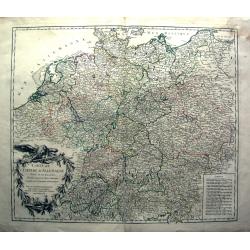
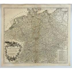
Carte de L'Empire D'Allemagne divisé en ses dix cercles,...
Detailed engraved map of all of Germany, extending to Northern Italy, Poland, Austria, Switzerland, the Benelux, and France. Filled with topographical information: Cit...
Date: Paris, 1756
Selling price: ????
Please login to see price!
Sold in 2011
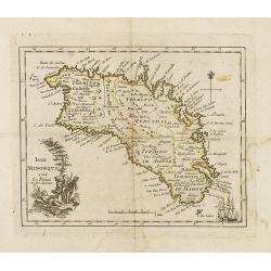
Isle Minorque.
Nice map of the island of Majorca, title cartouche lower left. Orientated to the north.
Date: Paris, 1756
Selling price: ????
Please login to see price!
Sold
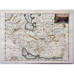
L'Empire de Perse.
Detailed map showing the Persian Empire, from Tartaria and the Caspian Sea to the Indian Ocean and Persian Gulf. With decorative title cartouche featuring a vignette at t...
Date: Paris, 1756
Selling price: ????
Please login to see price!
Sold in 2018
Nuova carte dell' India di là del Fiume Ganges overo di Malacca Siam Cambodia Chiampa KoChinchina Laos Pegu ava&c.
Fine map of Malay Peninsular, with present-day Thailand, taken from Storia moderna di tutti I popoli del mondo , edited by Thomas Salmon. A Italian edition of this famous...
Date: Venice, 1740-1756
Selling price: ????
Please login to see price!
Sold in 2013
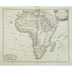
L'Afrique dressée sur les relations les plus récentes et assujettie aux observations astronomiques. . .
Very attractive map of the whole of Africa from Atlas Universel. Title cartouche with Lion and palm trees.
Date: Paris, 1756
Selling price: ????
Please login to see price!
Sold in 2013
Partie occidentale de la Lombardie. . .
Detailed map of the region of the north of Italy from his "Atlas Universel." Gilles Robert de Vaugondy (1688–1766), also known as Le Sieur or Monsieur Robert,...
Date: Paris, 1756
Selling price: ????
Please login to see price!
Sold in 2011
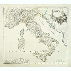
Carte de l'Italie dans laquelle sont tracées les routes des postes.
post road maps map of Italy, including the island of Corsica, Sardine and Sicilia from his "Atlas Universel".Gilles Robert de Vaugondy (1688–1766), also known...
Date: Paris, 1756
Selling price: ????
Please login to see price!
Sold in 2014
Partie occidentale de la Lombardie qui comprend la République de Venise. . .
Detailed map of region of north of Italia from his "Atlas Universel".Gilles Robert de Vaugondy (1688–1766), also known as Le Sieur or Monsieur Robert, and his...
Date: Paris, 1756
Selling price: ????
Please login to see price!
Sold in 2011
Carte des Possessions Françoises et Angloises dans le Canada et partie de la Lousiane. . .
First state, separately published. This map was published in 1756 to provide information on the French-Indian wars.
Date: Paris, 1756
Selling price: ????
Please login to see price!
Sold in 2013
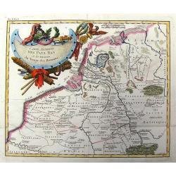
Carte Ancienne des Pays Bas et des Environs du Temps des Romains.
Copper engraved map of The Netherlands in the time of the domination by the Roman Empire. The map also includes portions of Belgium and Germany. The Renaissance title car...
Date: Paris, 1756
Selling price: ????
Please login to see price!
Sold in 2013
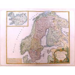
Les Royaumes de Suede et de Norwege.
Detailed, large map of Scandinavia published in Vaugondy's "Atlas Universel," one of the best-selling French atlases of the 1700s. It has a large, fancy title c...
Date: Paris, 1756
Selling price: ????
Please login to see price!
Sold in 2013
Grundriss von der Stadt Boston und ihren Gegenden.
Rare German edition of the Bellin plan of the city of Boston, its harbor and its surrounding area.The most important buildings, forts with their amount of cannons, lighth...
Date: Paris, 1756
Selling price: ????
Please login to see price!
Sold in 2014
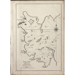
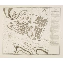
Plan de la Ville et du Port Mahon et du Fort St. Philippe.
Scarce separately issued map of the fort and town St.Philippe and port Mahon in a first state. In upper left corner the title and a key in French (A-Z, Aa-Bb) and a key i...
Date: Paris, ca. 1756
Selling price: ????
Please login to see price!
Sold in 2013
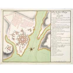
Plan du Fort St. Philippe et de ses Environs : Situés à l'entrée du Port Mahon dans l'Isle de Minorque / Envoyés par Mgr le Marechal Duc de Richelieu. . .
Separately published print of Fort Philippe with numbered key [key: 1-51] to the right. Published on 24 May 1756 by R.J. Julien à l'Hotel de Soubise in Paris. According ...
Date: Paris, ca. 1756
Selling price: ????
Please login to see price!
Sold in 2013
Plan du fort St. Philipe en l'isle de Minorque. . .
Manuscript plan of Fort Philippe with a lettered key [key: A-Z a-h] to the right. This manuscript plan is very similar to the separately published plan by R.J. Julien of...
Date: Paris, ca. 1756
Selling price: ????
Please login to see price!
Sold in 2016
Plan de Lisle de Minorque. / Plan du port Mahon.
Manuscript map of the island of Minorca. The left hand part shows the Bay of Mahon with the town of Mahon and Fort Philippe with a lettered key [A-Z &].The map is fil...
Date: Paris, ca. 1756
Selling price: ????
Please login to see price!
Sold
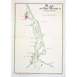
Plan du Port Mahon à l'isle de Minorque.
Uncommon early French manuscript map of the bay and town-planof port Mahón. The entrance of the bay is blocked by "Staccades". St. Philip's Castle still in it ...
Date: Minorca ? / France, ca. 1756
Selling price: ????
Please login to see price!
Sold
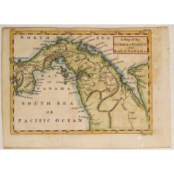
A Map of the Isthmus of Darien and Bay of Panama.
A fine little map featuring the Isthmus of Darien and Bay of Panama. Crrently, the country of Panama and the Panama Canal are located in this Isthmus. Block cartouche. T...
Date: London, 1756
Selling price: ????
Please login to see price!
Sold in 2013
Carte des Possessions Françoises et Angloises dans le Canada et Partie de la Louisiana. . .
First state of this separately published map of the European Colonies in the New World east of the Mississippi River. This map was published in 1756 to provide informatio...
Date: Paris, 1756
Selling price: ????
Please login to see price!
Sold in 2021
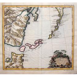
Carte des Isles Kouriles D'apres la Carte Russe.
A striking map of the Kuril Islands off the shore of Japan. The ownership of these volcanic islands has been in contention between Russia and Japan. The southern part of ...
Date: Paris, 1756
Selling price: ????
Please login to see price!
Sold in 2019
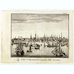
La Citta d'Amsterdam Capitale della Olanda.
Fine panoramic view of Amsterdam seen from the Y, taken from Storia moderna di tutti I popoli del mondo , edited by Thomas Salmon. A Italian edition of this famous work, ...
Date: Venice, 1740-1756
Selling price: ????
Please login to see price!
Sold in 2019
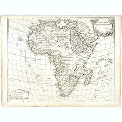
L'Afrique dressée sur les relations les plus récentes et assujettie aux observations astronomiques. . .
Very attractive map of the whole of Africa from Atlas Universel. Title cartouche with Lion and palm trees. Most of the text underneath the signature erased. A rare later ...
Date: Paris, after 1756
Selling price: ????
Please login to see price!
Sold in 2015
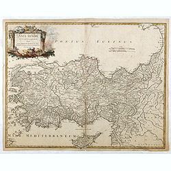
Asia Minor in suas partes seu provincias divisa. . . (Turkey with Cyprus)
Detailed map of Ancient Turkey with Cyprus from his "Atlas Universel".Gilles Robert de Vaugondy (1688–1766), also known as Le Sieur or Monsieur Robert, and hi...
Date: Paris, 1756
Selling price: ????
Please login to see price!
Sold in 2015
Partie occidentale de la Lombardie. . .
Detailed map of region of north of Italy from his "Atlas Universel".Gilles Robert de Vaugondy (1688–1766), also known as Le Sieur or Monsieur Robert, and his ...
Date: Paris, 1756
Selling price: ????
Please login to see price!
Sold in 2016
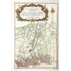
A New and Accurate Survey of the Parishes of St. Andrew's Holburn....
A fine, detailed hand-colored map of the Charterhouse Liberty area. From Maitland's "THE HISTORY AND SURVEY OF LONDON" published by Osborne & Shipton in Lon...
Date: London, 1756
Selling price: ????
Please login to see price!
Sold in 2016
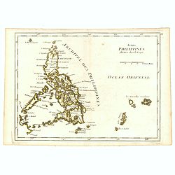
Isles Philippines.
Fine map of the Philippines. George Louis Le Rouge was active from 1740- till 1780 as a publisher, and was appointed engineer for the King of France. From his Atlas Nouve...
Date: Paris, 1756
Selling price: ????
Please login to see price!
Sold in 2016
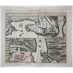
VORSTELLUNG einiger Gegender und Plaetze in NORD-AMERICA
A copperplate, old colored map consisting of three different Plans, issued during the early days of the Seven Years’ War for commercial reasons. Heir Homann produced th...
Date: Nuremberg, 1756
Selling price: ????
Please login to see price!
Sold in 2017
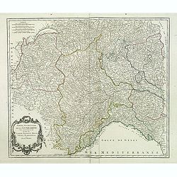
Carte de la Lorraine et du Barbois ....
Striking 1756 map of the French wine making region of Lorraine by Robert de Vaugondy. It covers the north east portion of France along with parts of neighboring Germany f...
Date: Paris , 1756
Selling price: ????
Please login to see price!
Sold in 2017
Carte de L'Empire D'Allemagne Divise en Ses Dix Cercles.
A detailed map of Germany, including the Low Countries, Bohemia and Poland. It shows political divisions, numerous place names, rivers and topography. It is decorated by ...
Date: Paris, 1756
Selling price: ????
Please login to see price!
Sold in 2017
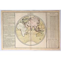
Climats d'Heures et de Mois.
A decorative map of the World showing one hemisphere divided into climates according to the length of the day. Left and right a box with information about these climates....
Date: Paris, 1756
Selling price: ????
Please login to see price!
Sold in 2019
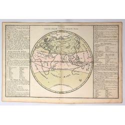
Division Generale et Naturelle de la Terre, Suivant les Anciens.
A decorative map of the Eastern Hemisphere, illustrating the zones of the world. With an incomplete image of Australia. Russia is labelled Tierre Incognita.Prepared by de...
Date: Paris, 1756
Selling price: ????
Please login to see price!
Sold in 2019
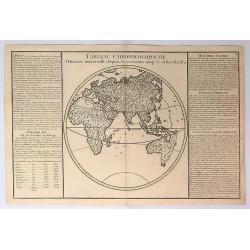
Tableau Chronologique de L'histoire Universelle Depuis la Creation Jusqu'a a Jesus Christ.
This map shows the history from the time of Christ, with the titles; Avant, Premier Age, Histoire Sacree, Histoire Profane and Situation du Paradis Terrestre. It is inter...
Date: Paris, 1756
Selling price: ????
Please login to see price!
Sold in 2019
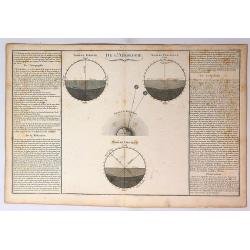
De L'Aerologie.
A decorative map showing four celestial models. Left and right boxes with geographical information about aerology,refraction and twilight.Prepared by de Mornas, who was a...
Date: Paris, 1756
Selling price: ????
Please login to see price!
Sold in 2017
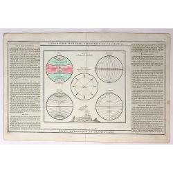
Geographie Modern Historique et Politique.
A set of five globes featuring Zones, Longitude, Antiodes, Climates and Latitude. It has the explanations outlined in the right and left boxes. Prepared by de Mornas, wh...
Date: Paris, 1756
Selling price: ????
Please login to see price!
Sold in 2017
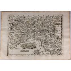
La Lombardie le Cours du Po & le Duche de Toscane...
A fine map of northern Italy with a decorative cartouche illustrating some vessels in the gulf of Genoa. With manuscript notes in right margin giving some historical info...
Date: Paris, 1756
Selling price: ????
Please login to see price!
Sold in 2018
L'Empire du Japon. . .
Very similar to Joan Blaeu's map of 100 years previously: Europeans by then had been expelled, except the Dutch, whose movements were so curtailed that they were not able...
Date: Paris, 1756
Selling price: ????
Please login to see price!
Sold in 2019
Isles Philippines.
Fine map of the Philippines. George Louis Le Rouge was active from 1740- till 1780 as a publisher, and was appointed engineer for the King of France. From his Atlas Nouve...
Date: Paris, 1756
Selling price: ????
Please login to see price!
Sold in 2018
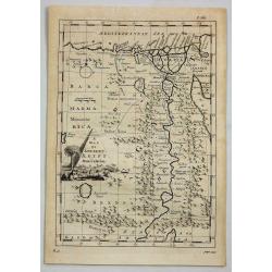
A Map of Ancient Aegypt from Celarius.
A fine map of Ancient Egypt with its cities and topography. There is a decorative title cartouche in the shape of a pyramid, surrounded by ancient Egyptian antiquities su...
Date: London, 1756
Selling price: ????
Please login to see price!
Sold in 2021
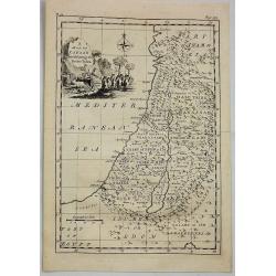
A Map of Canaan Divided Among the Twelve Tribes.
An Old Testament Israel showing its twelve divisions according to the tribes. With a decorative title cartouche depicting the Ark of the Covenant, various temple tools an...
Date: London, 1756
Selling price: ????
Please login to see price!
Sold in 2019