Browse Listings
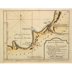
Carte de la Coste d' Angola Depuis la Riviere de Bengo jusqu'a Quanza.
Jaques Nicolas Bellin (1702-720) was the most important French hydrographer of the 18th century. Sea-atlas 'Hydrographique Français' , 1756-65, atlas to accompany Prévo...
Date: Paris, c. 1755
Selling price: ????
Please login to see price!
Sold in 2018
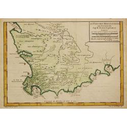
Le Pays des Hottentots.
Jaques Nicolas Bellin (1702-720) was the most important French hydrographer of the 18th century. Sea-atlas 'Hydrographique Français' , 1756-65, atlas to accompany Prévo...
Date: Paris, c. 1755
Selling price: ????
Please login to see price!
Sold in 2018
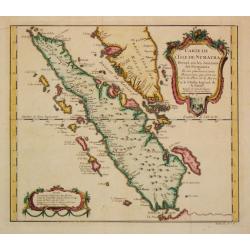
Carte d L' Isle de Sumatra.
Jaques Nicolas Bellin (1702-720) was the most important French hydrographer of the 18th century. Sea-atlas 'Hydrographique Français' , 1756-65, atlas to accompany Prévo...
Date: Paris, c. 1755
Selling price: ????
Please login to see price!
Sold in 2008
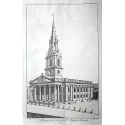
A set of 10 views of London Church's engraved by Benjamin Cole.
10 Original antique copper engravings For William Maitlands "History of London" Published in London, 1755. Titles: A PERSPECTIVE VIEW OF ST. MARTINS CHURCH....
Date: London, 1755
Selling price: ????
Please login to see price!
Sold in 2016
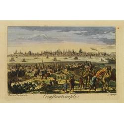
Constantinople.
Decorative engraving from Thomas Salmon's The Universal Traveller .
Date: London 1755
Selling price: ????
Please login to see price!
Sold
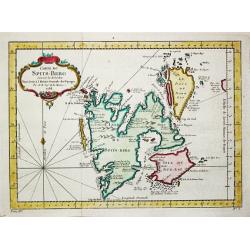
Carte du Spits-Berg.
A map of the island of Spitsbergen where the Dutch had a whaling station in the summer season.Jacques Nicolas Bellin (1702-720) was the most important French hydrographer...
Date: Paris. c. 1755
Selling price: ????
Please login to see price!
Sold in 2018

De Tegenwoordige Staat van Groot Brittannie, IIe Deel.
Izaak Tirion (d. 1769) Amsterdam publisher. Published ' Tegenwoordige staat van alle volkeren', a series of descriptions of countries and their inhabitants.Frontispice wi...
Date: Amsterdam, 1755
Selling price: ????
Please login to see price!
Sold in 2020
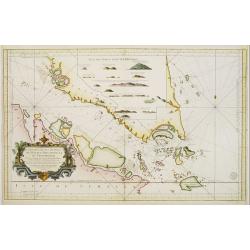
Carte Réduite des Detroits de Malaca, Sincapour..
Attractive large showing Malay Peninsula from north of Selangor to Pulor Tioman with adjacent coast of Sumatra and the islands southwards to Lingga. Latitude and longitu...
Date: Paris 1755
Selling price: ????
Please login to see price!
Sold
Nieuwe Kaart van het Oostelyckste Deel der Weereld.
Izaak Tirion (d. 1769) Amsterdam publisher. His ' Nieuwe en beknopte handatlas' saw 6 editions between before 1740 and after 1784. Also ' Tegenwoordige staat van alle vol...
Date: Amsterdam, 1755
Selling price: ????
Please login to see price!
Sold in 2009
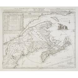
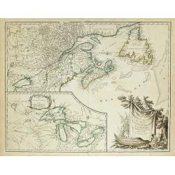
Partie de l'Amerique Septent? qui comprend la Nouvelle France ou le Canada..
Robert de Vaugondy's superb map of French Canada with an inset on the lower left of the still not completely defined Great Lakes.The highly decorative title cartouche fea...
Date: Paris 1755
Selling price: ????
Please login to see price!
Sold
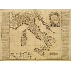
L'Italie Divisée en tous ses Estats..
RARE map of Italy prepared by J.B.Nolin and published by Daumont. A visually stunning map with a large title cartouche.To the left and right text boxes with a geographica...
Date: Paris 1755
Selling price: ????
Please login to see price!
Sold
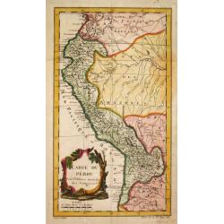
Carte du Pérou.
Jaques Nicolas Bellin (1702-720) was the most important French hydrographer of the 18th century. Sea-atlas 'Hydrographique Français' , 1756-65, atlas to accompany Prévo...
Date: Paris, c. 1755
Selling price: ????
Please login to see price!
Sold
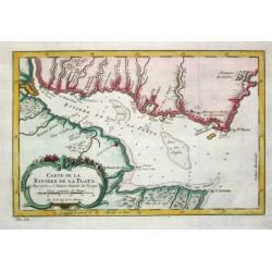
Carte de la Riviere de la Plata.
Jaques Nicolas Bellin (1702-720) was the most important French hydrographer of the 18th century. Sea-atlas 'Hydrographique Français' , 1756-65, atlas to accompany Prévo...
Date: Paris, c. 1755
Selling price: ????
Please login to see price!
Sold
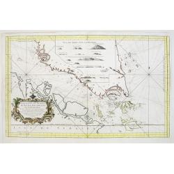
Carte Réduite des Detroits de Malaca, Sincapour, et du gouverneur
Attractive large chart showing Malay Peninsula from north of Selangor to Pulor Tioman with adjacent coast of Sumatra and the islands southwards to Lingga. Latitude and lo...
Date: Paris, 1755
Selling price: ????
Please login to see price!
Sold
Nieuwe kaart van de Grootbrittannische volkplantingen ..
A wonderful map of the situation in North America at the beginning of the French & Indian War. By the middle of the eighteenth century, the French, who claimed the en...
Date: Amsterdam 1755
Selling price: ????
Please login to see price!
Sold
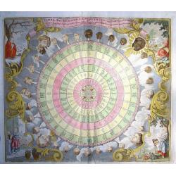
TABULA ANEMOGRAPHICA SEU PYXIS NAUTICA VULGO COMPASS CHARTE
Rare engraved wind chart showing the compass disc divided in 32 sections, with text in six languages (German, Dutch, Italian, Latin, French and Spanish). Surrounding th...
Date: Augsburg, c. 1755
Selling price: ????
Please login to see price!
Sold in 2008
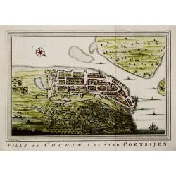
Ville de Cochin / De Stad Coetsijen.
Jaques Nicolas Bellin (1702-720) was the most important French hydrographer of the 18th century. Sea-atlas 'Hydrographique Français' , 1756-65, atlas to accompany Prévo...
Date: Amsterdam, c. 1755
Selling price: ????
Please login to see price!
Sold
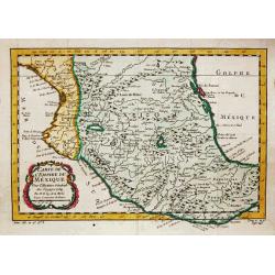
Carte de l'Empire de Mexique, 1754.
Jaques Nicolas Bellin (1702-720) was the most important French hydrographer of the 18th century. Sea-atlas 'Hydrographique Français' , 1756-65, atlas to accompany Prévo...
Date: Paris, c. 1755
Selling price: ????
Please login to see price!
Sold in 2020
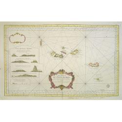
Carte Réduite des Isles Açores Pour servir aux Vaisseaux du Roy..
A well engraved and highly detailed chart. It shows soundings, anchorage's, channels, shoals, navigational sightings. Engraved by Petit, engraver for the Depot Générale...
Date: Paris, 1755
Selling price: ????
Please login to see price!
Sold in 2020
Tabula Anemographica seu Pyxis Nautica...
Tabula Anemographica seu Pyxis Nautica, vulgo Compass Charte. Rare engraved wind chart showing the compass disc divided in 32 sections, with text in six languages (German...
Date: Augsburg, 1755
Selling price: ????
Please login to see price!
Sold in 2014
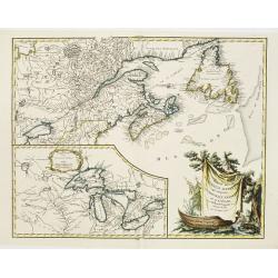
Nouvelle Ecosse ou Partie Orientale du Canada ...
A Parisian edition of Thomas Jeffery's map of Nova Scotia and Cape Britain. At the time of publication, 1755, Great Britain and France were in dispute over their boundary...
Date: Paris, 1755
Selling price: ????
Please login to see price!
Sold in 2014
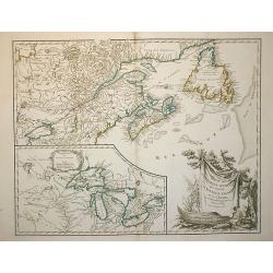
Partie de l\'Amerique Septent? Qui comprend la Nouvelle France ou le Canada ?
Robert de Vaugondy's superb map of French Canada with an inset on the lower left of the still not completely defined Great Lakes.The highly decorative title cartouche fea...
Date: Paris, 1755
Selling price: ????
Please login to see price!
Sold in 2009
Partie de l\'Amerique Septent? Qui comprend la Nouvelle France ou le Canada ?
Robert de Vaugondy's superb map of French Canada with an inset on the lower left of the still not completely defined Great Lakes.The highly decorative title cartouche fea...
Date: Paris, 1755
Selling price: ????
Please login to see price!
Sold in 2010
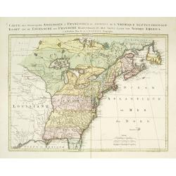
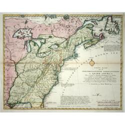
Carte des possessions Angloises et Françoises du continent de l'Amerique Septentrionale. / Kaart van de Engelsche en Fransche bezittingen . . .
A great French and Indian War map, with the states of Florida, Georgia, North and South Carolina, Virginia, Pennsylvania, Maryland, Jersey, New York, Connecticut, Massach...
Date: Amsterdam, 1755
Selling price: ????
Please login to see price!
Sold in 2019
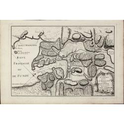
L'Isthme de l'Acadie Baye du Beaubassin en Anglois Shegnekto. Environs du Fort Beausejour.
Important and very rare map describing the first battle of the French and Indian War in Canada in 1755The copper engraved map published by G. L. le Rouge in 1755 showing ...
Date: Paris, 1755
Selling price: ????
Please login to see price!
Sold in 2011
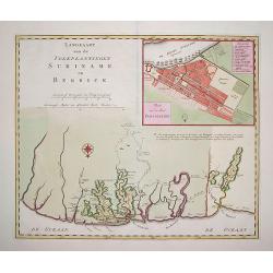
Landkaart van den Volkplantingen Surianme en Berbice.
Beautifully delineated map of Suriname identifying major plantations, waterways and towns. There is a plan of the capital, Paramaribo, in the upper right and corner with ...
Date: Amsterdam, ca. 1755
Selling price: ????
Please login to see price!
Sold in 2011
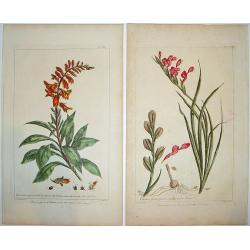
Figures of the Most Beautiful and Uncommon Plants. . .
Two marvelous hand-colored engravings from this scarce and important botanical book. Scottish botanist Phillip Miller (1691-1771) was the curator at the Chelsea Physic Ga...
Date: London, ca. 1755
Selling price: ????
Please login to see price!
Sold in 2013
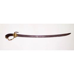
A Dutch East India Company sword dated 1755.
VOC-sword, comprising a strongly curved fluted wooden grip, the pommel-cap continuing its surface shape, ferrule, knuckle-guard screwed to the pommel and with a down-turn...
Date: Indonesia, 1755
Selling price: ????
Please login to see price!
Sold in 2012
Tatariae Sinensis mappa Geographica. . .
A fine large-scale map derived from d'Anville and prepared by Johann Tobias Mayer . Including far western China and Mongolia, Japan, Korea and Manchuria. Dense with old p...
Date: Nuremberg, 1755
Selling price: ????
Please login to see price!
Sold in 2011
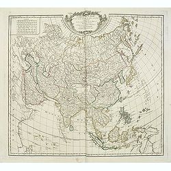
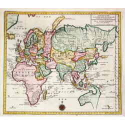
Carte de L'Asie dressée sur les Relations les plus nouvelles principalement. . .
Detailed map of Asia from the Atlas Universel , first published in 1755. The map is detailed, precisely engraved and not given to the fanciful cartography being promoted ...
Date: Paris, 1755
Selling price: ????
Please login to see price!
Sold
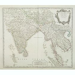
Les Indes Orientales, ou sont distingues les Empires et Royaumes. . .
Interesting regional map extending from India, the Ganges and the Maldive Islands to Hai-nan, Cochinchina, Malacca and Sumatra. Includes islands, "Sinca poura" ...
Date: Paris, ca. 1755
Selling price: ????
Please login to see price!
Sold in 2021
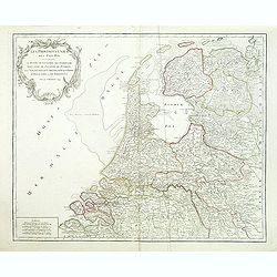
Provinces-Unies des Pays-Bas, . . .
Detailed map of the Netherlands, identifying the various provinces, with a large decorative cartouche. From his "Atlas Universel".Gilles Robert de Vaugondy (168...
Date: Paris, 1755
Selling price: ????
Please login to see price!
Sold in 2011
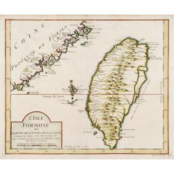
L'Isle Formose et parties des Costes de la Chine..
This well-known map of Taiwan is prepared by Jacques Nicolas Bellin and was based on Jesuit information. The text along the island's east-coast claims: Of this coast litt...
Date: Paris, 1756
Selling price: ????
Please login to see price!
Sold in 2019

La Saxe Contenant le Routes et les postes. . .
Fine post-route map of Saxony in Germany with a splendidly engraved title cartouche. The map is centered on Leipzig. George Louis Le Rouge was active between 1740 and 178...
Date: Paris, 1756
Selling price: ????
Please login to see price!
Sold in 2025
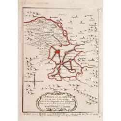
Carte du Lac de Mexico et de ses Environs.
"Uncommon edition of this accurate map showing Mexico City and surrounding areas, the ranges and villages of numerous Indian tribes are shown.From Atlas Portatif pou...
Date: Amsterdam 1756
Selling price: ????
Please login to see price!
Sold
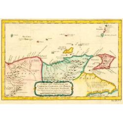
Carte des Provinces des Caracas, Comana et Paria.
Jaques Nicolas Bellin (1702-720) was the most important French hydrographer of the 18th century. Sea-atlas "Hydrographique Français", 1756-65, atlas to accompa...
Date: Paris, c. 1756
Selling price: ????
Please login to see price!
Sold in 2009
![Plan Du Port De Lisbonne Et Des Costes Voisines.. [Lisbon]](/uploads/cache/23031-250x250.jpg)
Plan Du Port De Lisbonne Et Des Costes Voisines.. [Lisbon]
A well engraved and highly detailed chart of Lisbon harbour with a decorative horizontal panorama along upper part. It shows soundings, anchorage's, channels, shoals, nav...
Date: Paris, 1756
Selling price: ????
Please login to see price!
Sold
![[Titlepage] Augsburgische Sämlung derer wegen des .. Portugal und Spanien ..](/uploads/cache/21222-250x250.jpg)
[Titlepage] Augsburgische Sämlung derer wegen des .. Portugal und Spanien ..
Decorative and uncommon title page, enclosed in an architectural framework engraved with cherubs and a woman holding a coat of arms.
Date: Augsburg, 1756
Selling price: ????
Please login to see price!
Sold in 2009
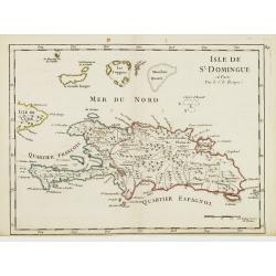
Isle de St. Domingue.
Fine map of Haiti and the Dominican Republic. Striking map of the island with detailed rendering of roads and topography. George Louis Le Rouge was active from 1740- till...
Date: Paris 1756
Selling price: ????
Please login to see price!
Sold
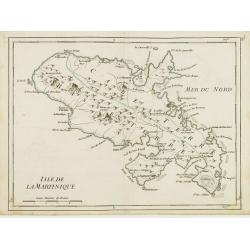
Isle de la Martinique.
Detailed map on the island of Martinique in the Caribbean. Villages, forts, mountains and bays all around the island are named. George Louis Le Rouge was active from 1740...
Date: Paris 1756
Selling price: ????
Please login to see price!
Sold
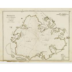
Antigue une des Antilles aux Anglois.
Fine map of Antigua with locations of forts, settlements, and plantations with details of the coastline, anchorages and navigational hazards.George Louis Le Rouge was act...
Date: Paris 1756
Selling price: ????
Please login to see price!
Sold
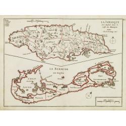
La Jamaique.. La Bermude..
Two maps on one sheet, Jamaica above Bermuda. Jamaica is engraved to show the plantations, denoting those growing sugar, cotton, cacao, and indigo. The map of Bermuda inc...
Date: Paris 1756
Selling price: ????
Please login to see price!
Sold
L'Isle St. Christophle.. La Barbade..
Two maps on one sheet showing Barbados and St. Christophers. George Louis Le Rouge was active from 1740- till 1780 as a publisher, and was appointed engineer for the King...
Date: Paris 1756
Selling price: ????
Please login to see price!
Sold
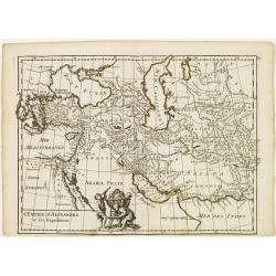
L'Empire d'Alexandre et ses Expeditions.
Fine map showing the territory conquered by Alexander the Great. With decorative cartouche on lower part, left to center fold. George Louis Le Rouge was active from 1740-...
Date: Paris, 1756
Selling price: ????
Please login to see price!
Sold in 2015
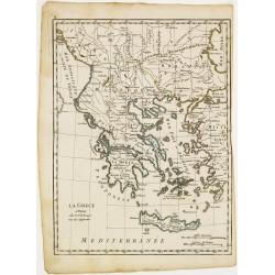
La Grece.
Fine map of Greece. George Louis Le Rouge was active from 1740- till 1780 as a publisher, and was appointed engineer for the King of France. From his Atlas Nouveau Portat...
Date: Paris 1756
Selling price: ????
Please login to see price!
Sold
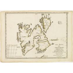
Les Isles du Spitsberg.
Fine map of Spitsbergen. George Louis Le Rouge was active from 1740- till 1780 as a publisher, and was appointed engineer for the King of France. From his Atlas Nouveau P...
Date: Paris 1756
Selling price: ????
Please login to see price!
Sold
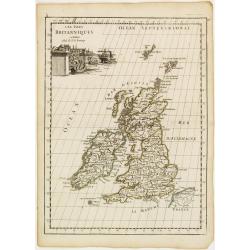
Les Isles du Britanniques.
Fine map of the British Isles with a fine cartouche depicting vessels approaching the harbour.George Louis Le Rouge was active from 1740- till 1780 as a publisher, and wa...
Date: Paris 1756
Selling price: ????
Please login to see price!
Sold
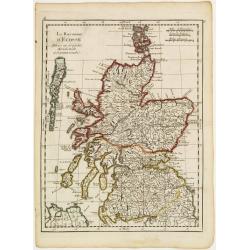
Le Royaume d'Ecosse..
Fine map of Scotland. George Louis Le Rouge was active from 1740- till 1780 as a publisher, and was appointed engineer for the King of France. From his Atlas Nouveau Port...
Date: Paris 1756
Selling price: ????
Please login to see price!
Sold
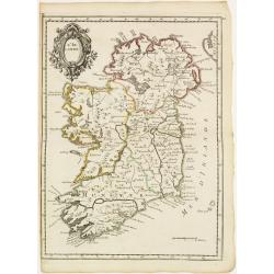
L'Irlande.
Fine map of Ireland with a decorative title cartouche. George Louis Le Rouge was active from 1740- till 1780 as a publisher, and was appointed engineer for the King of Fr...
Date: Paris 1756
Selling price: ????
Please login to see price!
Sold
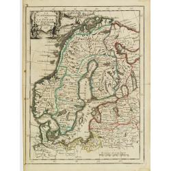
La Scandinavie ounla Suede et Danmark.
Fine map of Scandinavia with a decorative title cartouche. George Louis Le Rouge was active from 1740- till 1780 as a publisher, and was appointed engineer for the King o...
Date: Paris 1756
Selling price: ????
Please login to see price!
Sold
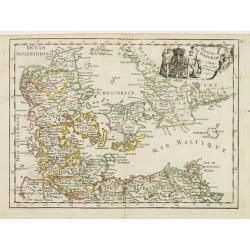
Royaume de Danemarck.
Fine map of Denmark with a decorative title cartouche. George Louis Le Rouge was active from 1740- till 1780 as a publisher, and was appointed engineer for the King of Fr...
Date: Paris 1756
Selling price: ????
Please login to see price!
Sold
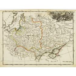
La Pologne.
Fine map of Poland. George Louis Le Rouge was active from 1740- till 1780 as a publisher, and was appointed engineer for the King of France. From his Atlas Nouveau Portat...
Date: Paris 1756
Selling price: ????
Please login to see price!
Sold
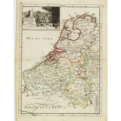
Les XVII Provinces des Pays Bas.
Fine map of the Netherlands with a decorative title cartouche. George Louis Le Rouge was active from 1740- till 1780 as a publisher, and was appointed engineer for the Ki...
Date: Paris 1756
Selling price: ????
Please login to see price!
Sold
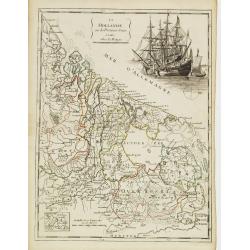
La Hollande ou les Provinces Reunies.
Fine map of Holland including Zeeland, Brabant, Utrecht, Overijssel, Friesland and Groningen. It presents a decorative cartouche on upper right corner depicting two large...
Date: Paris 1756
Selling price: ????
Please login to see price!
Sold
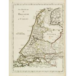
Les Provinces de Hollande et d'Utrecht.
Fine map of Holland and Utrecht. George Louis Le Rouge was active from 1740- till 1780 as a publisher, and was appointed engineer for the King of France. From his Atlas N...
Date: Paris 1756
Selling price: ????
Please login to see price!
Sold
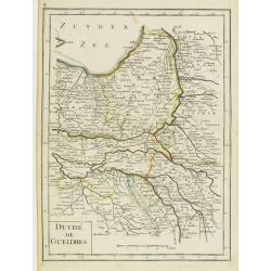
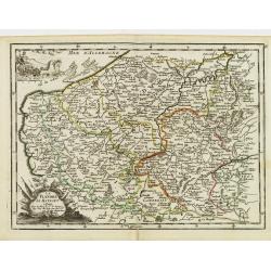
Duché de Gueldres.
Fine map of Gelderland. George Louis Le Rouge was active from 1740- till 1780 as a publisher, and was appointed engineer for the King of France. From his Atlas Nouveau Po...
Date: Paris 1756
Selling price: ????
Please login to see price!
Sold
Zelande.
Fine map of Zeeland with a decorative title cartouche. George Louis Le Rouge was active from 1740- till 1780 as a publisher, and was appointed engineer for the King of Fr...
Date: Paris 1756
Selling price: ????
Please login to see price!
Sold
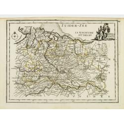
La Seigneurie d'Utrecht.
Fine map of Utrecht presenting a decorative cartouche on upper right corner. George Louis Le Rouge was active from 1740- till 1780 as a publisher, and was appointed engin...
Date: Paris 1756
Selling price: ????
Please login to see price!
Sold
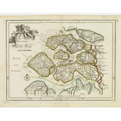
La Flandre Le Haynaut.
Fine map of the Flanders and the province of Hainaut. It presents a decorative title cartouche and a decorative cartouche on upper left corner. George Louis Le Rouge was ...
Date: Paris 1756
Selling price: ????
Please login to see price!
Sold
Duché de Luxembourg.
Fine map of Luxembourg with a decorative title cartouche. George Louis Le Rouge was active from 1740- till 1780 as a publisher, and was appointed engineer for the King of...
Date: Paris 1756
Selling price: ????
Please login to see price!
Sold
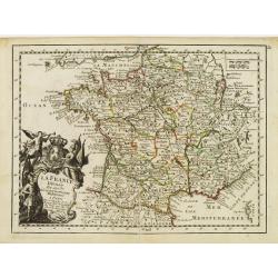
La France Divisée En ses 37 Gouvernements Militaires.
Fine map of France with decorative title cartouche. George Louis Le Rouge was active from 1740- till 1780 as a publisher, and was appointed engineer for the King of Franc...
Date: Paris 1756
Selling price: ????
Please login to see price!
Sold
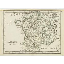
La France par Postes.
Fine map of France. George Louis Le Rouge was active from 1740- till 1780 as a publisher, and was appointed engineer for the King of France. From his Atlas Nouveau Portat...
Date: Paris 1756
Selling price: ????
Please login to see price!
Sold
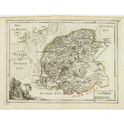
La Frise.
Fine map of Friesland with a decorative cartouche on lower left corner. George Louis Le Rouge was active from 1740- till 1780 as a publisher, and was appointed engineer f...
Date: Paris 1756
Selling price: ????
Please login to see price!
Sold
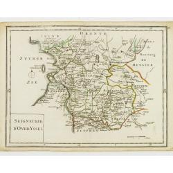
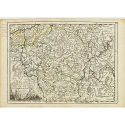
Seigneurie d'Over-Yssel.
Fine map of Overijssel. George Louis Le Rouge was active from 1740- till 1780 as a publisher, and was appointed engineer for the King of France. From his Atlas Nouveau Po...
Date: Paris 1756
Selling price: ????
Please login to see price!
Sold
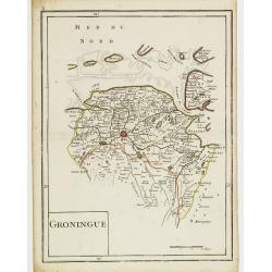
Groningue.
Fine map of Groningen. George Louis Le Rouge was active from 1740- till 1780 as a publisher, and was appointed engineer for the King of France. From his Atlas Nouveau Por...
Date: Paris 1756
Selling price: ????
Please login to see price!
Sold
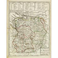
Carte Idéale du Brabant contenant les Camps de 1746 et 1747.
Fine map of Brabant. George Louis Le Rouge was active from 1740- till 1780 as a publisher, and was appointed engineer for the King of France. From his Atlas Nouveau Porta...
Date: Paris 1756
Selling price: ????
Please login to see price!
Sold
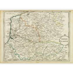
Artois Picardie.
Fine map of the French provinces of Picardy and Artois. George Louis Le Rouge was active from 1740- till 1780 as a publisher, and was appointed engineer for the King of F...
Date: Paris 1756
Selling price: ????
Please login to see price!
Sold
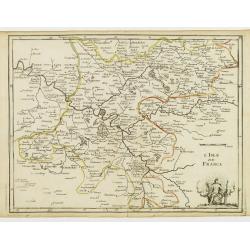
L'Isle de France.
Fine map of the French region Île de France whose chief town is Paris. It presents a decorative cartouche on lower right corner. George Louis Le Rouge was active from 17...
Date: Paris 1756
Selling price: ????
Please login to see price!
Sold
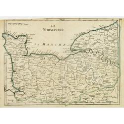
La Normandie.
Fine map of the French region Normandy. George Louis Le Rouge was active from 1740- till 1780 as a publisher, and was appointed engineer for the King of France. From his ...
Date: Paris 1756
Selling price: ????
Please login to see price!
Sold
La Champagne.
Fine map of the French region Champagne, with decorative title cartouche. George Louis Le Rouge was active from 1740- till 1780 as a publisher, and was appointed engineer...
Date: Paris 1756
Selling price: ????
Please login to see price!
Sold
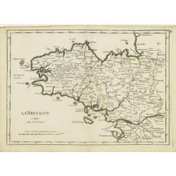
La Bretagne.
Fine map of the French region Brittany. George Louis Le Rouge was active from 1740- till 1780 as a publisher, and was appointed engineer for the King of France. From his ...
Date: Paris 1756
Selling price: ????
Please login to see price!
Sold
Orleanois, Perche, le Mans, Anjou, Tourraine, Berry.
Fine map of today's French region called Centre, including the towns of Orleans, Tours and Bourges. With decorative title cartouche. George Louis Le Rouge was active from...
Date: Paris 1756
Selling price: ????
Please login to see price!
Sold
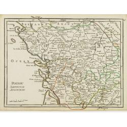
Poitou, Saintonge, Angoumois.
Fine map of the today's French region Poitou-Charente, including part of the Vendée. George Louis Le Rouge was active from 1740- till 1780 as a publisher, and was appoin...
Date: Paris 1756
Selling price: ????
Please login to see price!
Sold
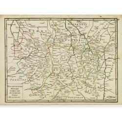
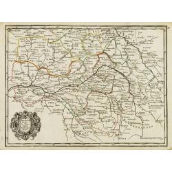
Bourbonnois, Marche, Limousin, Auvergne, Forez, Beaujolois.
Fine map of the today's French regions of Limousin and Auvergne, including part of the Rhône-Alpes region. George Louis Le Rouge was active from 1740- till 1780 as a pub...
Date: Paris 1756
Selling price: ????
Please login to see price!
Sold in 2010
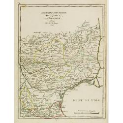
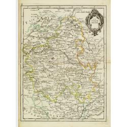
Languedoc, Roussillon, Foix, Quercy, et Rouergue.
Fine map of the French region Languedoc-Roussillon, including some territory at its East. George Louis Le Rouge was active from 1740- till 1780 as a publisher, and was ap...
Date: Paris 1756
Selling price: ????
Please login to see price!
Sold
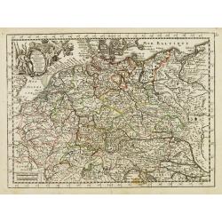
L'Empire d'Allemagne..
Fine map of Germany, with decorative title cartouche. George Louis Le Rouge was active from 1740- till 1780 as a publisher, and was appointed engineer for the King of Fra...
Date: Paris 1756
Selling price: ????
Please login to see price!
Sold
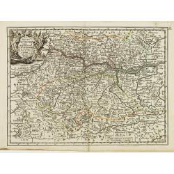
Le Cercle d'Autriche.
Fine map of Austria. It presents a decorative title cartouche and a cartouche depicting knights whose impression is slightly faded. George Louis Le Rouge was active from ...
Date: Paris 1756
Selling price: ????
Please login to see price!
Sold
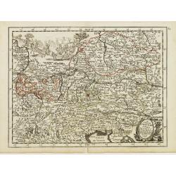
La Haute Autriche..
Fine map of the western part of Austria with a decorative title cartouche. George Louis Le Rouge was active from 1740- till 1780 as a publisher, and was appointed enginee...
Date: Paris 1756
Selling price: ????
Please login to see price!
Sold
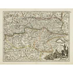
La Basse Autriche.
Fine map of the eastern part of Austria with a decorative title cartouche. George Louis Le Rouge was active from 1740- till 1780 as a publisher, and was appointed enginee...
Date: Paris 1756
Selling price: ????
Please login to see price!
Sold
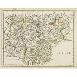
Le Tirol.
Fine map of Tyrol. In lower part Lake Garda and in upper right the skiing grounds of Innsbruck, Kuffstein, etc.George Louis Le Rouge was active from 1740- till 1780 as a ...
Date: Paris 1756
Selling price: ????
Please login to see price!
Sold