Browse Listings
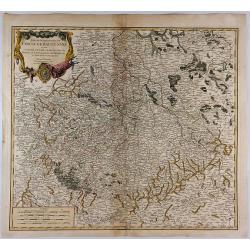
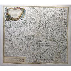
Partie Meridionale du Cercle de Haut Saxe. . .
This is a striking map of the historic provinces of le Duche de Saxe, le Marquisat de Minnie, & le Landgravlat de Thuringe, in France. The title is inside a richly de...
Date: Paris, 1753
Selling price: ????
Please login to see price!
Sold in 2018
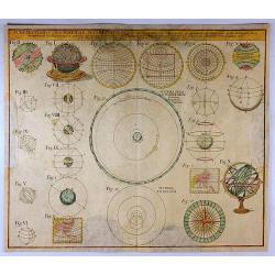
Schematismus Geographiae Mathematicae. . .
The uncommon Homann Heirs chart of the Solar System features 23 diagrams including spheres, earth, celestial globes, planetary systems, temperature zones, and projection ...
Date: Nuremberg, 1753
Selling price: ????
Please login to see price!
Sold in 2017
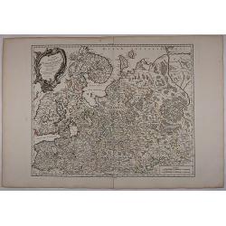
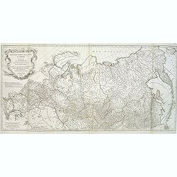
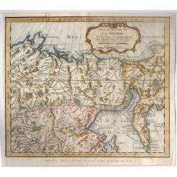
Partie Septentrionale De La Russie Europeenne... Par Le Sr Robert De Vaugondy Géog Ordin du Roi Avec privilege 1753.
Very detailed and large map of North West part of Russia, from the Gulf of Finland and Poland to the western part of Russia. Map dated.
Date: 1753
Selling price: ????
Please login to see price!
Sold in 2017
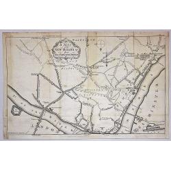
A Map of the New roads & c. from Westminster Bridge.
A detailed map of London, showing the road system south of the Thames River. The map is oriented with south at the top and extends from London Bridge, The Tower of London...
Date: London, 1753
Selling price: ????
Please login to see price!
Sold in 2019
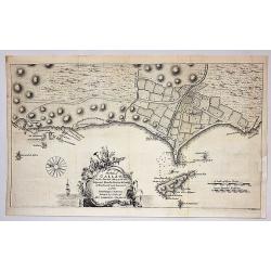
The Port of Callao in the South Sea with the Adjacent Islands, Rocks & Coasts.
A map by Thomas Jefferys, from The Gentleman's Magazine, published in London in 1753. This interesting map covers the present-day Lima Metropolitan Area, from the fishing...
Date: London, 1753
Selling price: ????
Please login to see price!
Sold in 2018
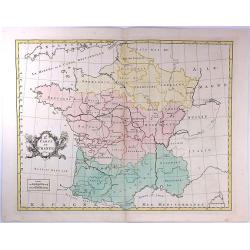
Gouvernements Generaux du Berry, du Nivernois et du Bourbonois.
An antique hand colored map of the Berry, Nivers, Bourbon regions of France, including Bourges and Nevers in central France. Features a decorative cartouche with fruits a...
Date: Paris, 1753
Selling price: ????
Please login to see price!
Sold in 2018
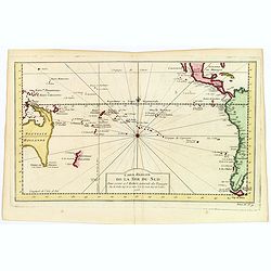
Carte Reduite de la Mer du Sud.
A nice map of the Pacific region as published by Bellin in Paris in the middle of the 18th century. It shows the eastern Australian coast 'as one', with Tasmania and Papu...
Date: Paris, 1753
Selling price: ????
Please login to see price!
Sold in 2019
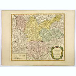
Le Tyrol sous le nom duquel. . .
Robert de Vaugondy's large map of the mountainous Tirol region spanning portions of northern Italy, eastern Switzerland, and western Austria from his "Atlas Universe...
Date: Paris, 1753
Selling price: ????
Please login to see price!
Sold in 2020
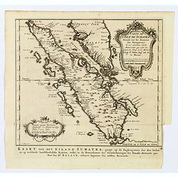
Carte de l'Isle de Sumatra. . . / Kaart van het Eiland Sumatra. . .
Map of Sumatra, also showing the tip of the Malay Peninsula and the Straits of Singapore. An unusually detailed map of the area, showing many coastal features, shoals, ba...
Date: The Hague, 1753
Selling price: ????
Please login to see price!
Sold in 2019
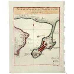
PLAN DE LA VILLE ET DU PORT DE MACAO.
A fine early map of Macao, published by Nicholas Bellin, the French Royal Hydrographer.
Date: Paris, 1753
Selling price: ????
Please login to see price!
Sold in 2020
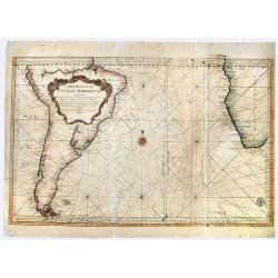
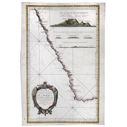
Carte Reduite de L' OCEAN MERIDIONAL Contenant Toutes les Costes de l' Amerique Meridionale. . .
A striking, large sea chart of the Southern Atlantic Ocean, showing most of the coast of South America and the Southwest coast of Africa, published by Nicolas Bellin. The...
Date: Paris, 1753
Selling price: ????
Please login to see price!
Sold in 2019
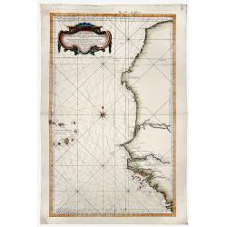
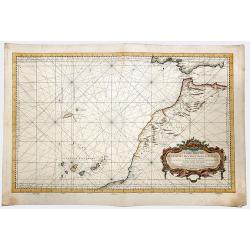
Carte Reduite DES COSTES OCCIDENTALES D' AFRIQUE Second fouille Depuis le Cap Bojador jusqu'a a la Riviere de Sierra Leona...
A beautiful map of the western coast of Africa. The map was published out of Paris by the Department de la Marine in 1765. This scarce sea chart covers the western coast ...
Date: Paris, 1753
Selling price: ????
Please login to see price!
Sold in 2019
Carte Reduite DES COSTES OCCIDENTALES D' AFRIQUE Premiere fouille contenant, Les Costes de Barbarie. . .
A beautiful map of the north western coast of Africa. The map was published out of Paris by the Department de la Marine in 1765. This scarce sea chart covers the north we...
Date: Paris, 1753
Selling price: ????
Please login to see price!
Sold in 2019
![Tabula Geographica. HEMISPHAERII BOREALIS. . . [North-West passage, Bay of the West]](/uploads/cache/83551-250x250.jpg)
Tabula Geographica. HEMISPHAERII BOREALIS. . . [North-West passage, Bay of the West]
A scarce map with original full wash hand coloring, of the north pole by Johann Cristoph Rhode, showing the hypothetical Mer de L’Ouest, with an extensive river system ...
Date: 1753
Selling price: ????
Please login to see price!
Sold in 2020
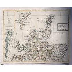
A New Map of the North Part of Scotland.
An antique map of the North Part of Scotland, drawn and engraved by Andrew Johnston, published in the third edition of William Camden's 'Britannia' in 1753. This map, and...
Date: Glasgow, 1753
Selling price: ????
Please login to see price!
Sold in 2023
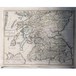
A New Map of the South Part of Scotland.
An antique map of the South Part of Scotland, drawn and engraved by Andrew Johnston, published in the third edition of William Camden's 'Britannia' in 1753. This map, and...
Date: Glasgow, 1753
Selling price: ????
Please login to see price!
Sold in 2023
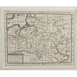
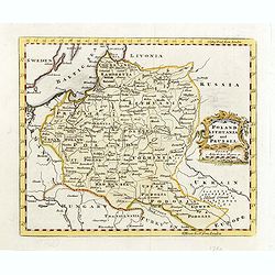
La Pologne.
An unusual 1752 Buffier copper engraved map of Poland. The map also covers Lithuania, part of Russia, Hungary, a portion of Ukraine, as well as a part of Romania. A decor...
Date: Paris, 1753
Selling price: ????
Please login to see price!
Sold in 2021
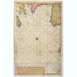
(Untitled sea chart of the North Sea with parts of the coasts of England, France, Ireland and Portugal.)
Center part of a larger sea chart of the North Sea with parts of the coasts of England, France, Ireland and Portugal. Scale in lower left.Sold as is.
Date: Amsterdam, 1753
Selling price: ????
Please login to see price!
Sold in 2021

Plan de la place de Corfu avec ses environs. . .
Uncommon map of the town of Kérkira and its siege in 1716, on the island of Corfu. Johann Baptist Homann's well-engraved map has a large decorative cartouche and in each...
Date: Nuremberg 1753
Selling price: ????
Please login to see price!
Sold in 2023
Carte Reduite d'Une Partie Des Costes Occidentales et Meridionales de l'Afrique.
A fine, beautiful colored sea chart of the Southwest Coast of Africa, published by Nicolas Bellin. With three insets showing vies of "Vue du Cap de Bonne Esperance&q...
Date: Paris, 1754
Selling price: ????
Please login to see price!
Sold in 2020
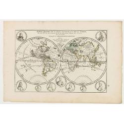
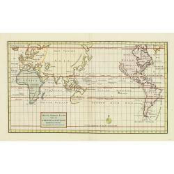
Mappe-Monde ou carte generale de la terre.
World map in two hemispheres prepared by de Lisle. The hemispheres are surrounded by small portraits of nine explorers: Père Tachard SJ, de la Salle, Dampier, Magellan, ...
Date: Paris, ca. 1754
Selling price: ????
Please login to see price!
Sold in 2020
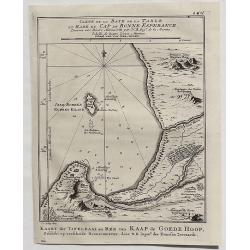
Carte de la Baye de la Table et Rade du Cap de Bonne Esperance. . .
A detailed map of the Table Bay and Robben Island at Cape Town, South Africa, extending north to Mountain Blue. Engraved by van der Schley.Jacques Nicolas Bellin (1703–...
Date: Paris, 1754
Selling price: ????
Please login to see price!
Sold in 2020
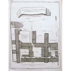
A plan of the ground and buildings in the Strand called the Savoy, taken in the year 1736.
A rare detailed plan of the Savoy between the Strand and the Thames in London. With details of each building and the business operating there. A scale bar shows distance ...
Date: London, ca 1754
Selling price: ????
Please login to see price!
Sold in 2020
Nieuwe Kaart Van het Oostelykste Deel der Weereld. . .
A very decorative map of the Eastern part of the world. It provides an excellent view of the still evolving cartography, particularly in the Far East. The delineation of ...
Date: Amsterdam, 1754
Selling price: ????
Please login to see price!
Sold in 2022
Nieuwe Kaart van het Westelykste Deel der Weereld. . .
A very decorative map of the Western part of the World by Isaac Tirion. The Americas display a speculative river to the West through North America, beginning at the Great...
Date: Amsterdam, 1754
Selling price: ????
Please login to see price!
Sold in 2022
A MAP OF THE BRITISH AMERICAN PLANTATIONS, Extending From Boston.Including All The Back Settlements In The Respective Provinces, As Far As The Mississippi
Covers New York and areas of New England, Pennsylvania, Maryland, Virginia, North and South Carolina, Georgia and other states reaching to the Mississippi River. Iden...
Date: London, 1754
Selling price: ????
Please login to see price!
Sold in 2023

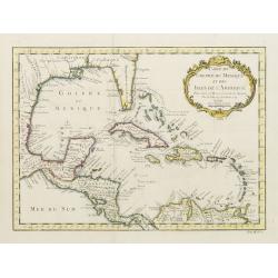
Carte du Golphe du Mexique et des Isles de l'Amerique.
Attractive map of the islands of the Caribbean that includes those parts of the United States & Mexico that border the Gulf of Mexico, Central America, and the northe...
Date: Paris, 1754
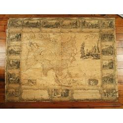
L'Asie divissée en tous ses etats,..
Uncommon wall map of the continent of Asia with some period color, composed from four joined sheets surrounded by text and vignettes printed on separate sheets.Published ...
Date: Paris 1754
Selling price: ????
Please login to see price!
Sold
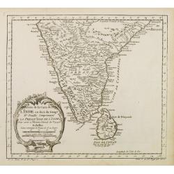
Suite de la Carte de L'Inde en deca du Gange..
A good engraved map of India with Sri Lanka, with rococo title cartouche lower left. From l'Histoire générale des voyages .
Date: Paris 1754
Selling price: ????
Please login to see price!
Sold
Essai D'Une Nouvelle Carte de la Mer Caspienne.
Simplistic map of the Caspian Sea.
Date: Paris, 1754
Selling price: ????
Please login to see price!
Sold in 2020
Carte du Golphe du Mexique et des Isles de l'Amerique.
Attractive map of the islands of the Caribbean that includes those parts of the United States & Mexico that border the Gulf of Mexico, Central America, and the northe...
Date: Paris 1754
Selling price: ????
Please login to see price!
Sold
Essai D'Une Nouvelle Carte de la Mer Caspienne.
Interesting map of the Caspian Sea between Russia and Iran. Jean Baptiste d'Anville (1697-1782) born in Paris was perhaps the most important and prolific cartographer of ...
Date: Paris, 1754
Selling price: ????
Please login to see price!
Sold in 2013
![[Eight scenes depicting various stages in the history of America]](/uploads/cache/25007-250x250.jpg)
[Eight scenes depicting various stages in the history of America]
The side border of Longchamps wall map of America, here still in its uncut form. The eight scenes depicting various stages in the history of the continent. - Monarchie de...
Date: Paris, 1754
Selling price: ????
Please login to see price!
Sold in 2008
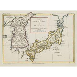
Carte de la Corée et du Japon. Par M.Brion de la Tour Ing.r Geographe du Roi.
Rare map of Japan and Korea prepared by Brion de la Tour.
Date: Paris, 1754
Selling price: ????
Please login to see price!
Sold in 2008
Nieuwe Wereld Kaart waar in de Reizen van den Hr. Anson rondsom de Wereld met een gestipte Linie worden Aangewezen.
A attractive world map in Mercator projection with the travels of Anson. California as an Island. Centered on Australia.Showing the route of Commodore Anson around the wo...
Date: Amsterdam, 1754
Selling price: ????
Please login to see price!
Sold in 2011
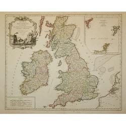
Les Isles Britanniques ...
Decorative map of British Isles with Rococo title cartouche and inset map with Shetland Islands.
Date: Paris, 1754
Selling price: ????
Please login to see price!
Sold in 2011
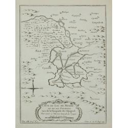
Carte du Lac de Mexico ...
A good engraved map of the capital of old Mexico, with rococo title cartouche lower part.From l'Histoire générale des voyages. Prepared by Jacques Nicholas Bellin (1703...
Date: Paris, 1754
Selling price: ????
Please login to see price!
Sold in 2011
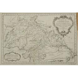
Carte de L'Indoustan ...
From l'Histoire générale des voyages. Prepared by Jacques Nicholas Bellin (1703-1772), one of the most important and proficient French cartographers of the mid-eighteen...
Date: Paris, 1754
Selling price: ????
Please login to see price!
Sold in 2011
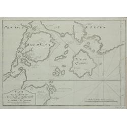
Carte de la Baye de Chin-Chew ...
A detailed small chart of the estuary of the Chiu-lung River at present-day Hsia-men, on the mainland coast, adjacent to Taiwan, showing the location of a few village set...
Date: Paris, 1754
Selling price: ????
Please login to see price!
Sold in 2011
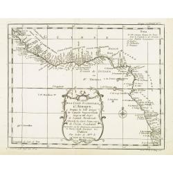
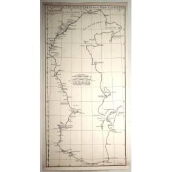
Carte De La Coste Occidentale D'Afrique Depuis le XII Dégré de Latitude Septentrionale Jusqu'au XI Dégré de Latitude Meridionale.
Very detailed map of Africa's western coast from Sierra Leone across to the Grain, Ivory, Gold and Slave coasts and Nigeria & the Gulf of Guinea. From thence the coas...
Date: Paris, 1754
Selling price: ????
Please login to see price!
Sold in 2012
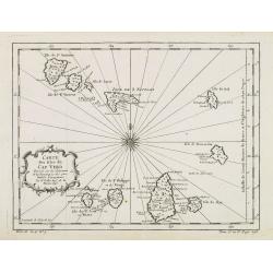
Carte des isles du Cap Verd..
This is one of the more detailed maps of the Cape Verde Islands of its time. The major settlements as well as topographical aspects are shown. A decorative wind rose near...
Date: Paris, 1754
Selling price: ????
Please login to see price!
Sold in 2008
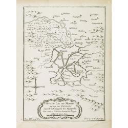
Carte du Lac de Mexico, et de ses environs Lors de la conqueste des Espagnols. . .
A good engraved map of the capital of old Mexico, with rococo title cartouche lower part. From l'Histoire générale des voyages.Mexico City showing its position on the L...
Date: Paris, 1754
Selling price: ????
Please login to see price!
Sold in 2014
Troisième partie de la carte d'Asie, contenant la Sibérie, et quelques autres parties de la Tartarie. . .
Engraved map of Tartary on two sheets, with country boundaries in out line color. Includes geographic notes and ornamental cartouche by "H. Gravelot, invenit., DeLaf...
Date: Paris, 1754
Selling price: ????
Please login to see price!
Sold in 2012
![Carte Reduite D'Une Partie Des Costes Occidentales et Meridionales De L'Afrique Depuis Cabo Frio ou Cap Froid . . . Jusque a la Bay S. Blaise . . . MDCCLIV [with view of Cape of Good Hope]](/uploads/cache/31261-250x250.jpg)
Carte Reduite D'Une Partie Des Costes Occidentales et Meridionales De L'Afrique Depuis Cabo Frio ou Cap Froid . . . Jusque a la Bay S. Blaise . . . MDCCLIV [with view of Cape of Good Hope]
Very large and detailed of the southern African coastline from Cape Fria in Namibia to Cape Agulhas. In lower left corner a rococo title cartouche and in top a profile o...
Date: Paris, Dépôt de la Marine, c.1754
Selling price: ????
Please login to see price!
Sold in 2011
KejserDommet China udkastet til den almindelige Reise-beskrivelse af N. Bellin Ing. de la Mar. 1748.
Extremely rare Danish issue of Bellin's three cartouche map of China. Bellin added this map to the Prevost itinerary, which has been published in French, Dutch, German, a...
Date: Copenhagen, 1754
Selling price: ????
Please login to see price!
Sold in 2013
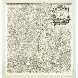
La principaute de Liege et le duche de Limbourg.
Detailled map of Belgium around Liege from his "Atlas Universel".Gilles Robert de Vaugondy (1688–1766), also known as Le Sieur or Monsieur Robert, and his son...
Date: Paris, 1754
Selling price: ????
Please login to see price!
Sold in 2013
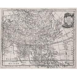
An Accurate Map of Asia According to the Latest Authorities by Emanuel Bowen.
An attractive map of Asia by Emanuel Bowen, includes Russia, China, Japan, India, the Malay peninsula, and much more.
Date: London, 1754
Selling price: ????
Please login to see price!
Sold in 2012
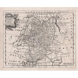
An accurate map of Moscovy or Russia in Europe drawn from the best Authorities - by Emanuel Bowen
An attractive and highly detailed small map of Russia by Emanuel Bowen.
Date: London, 1754
Selling price: ????
Please login to see price!
Sold in 2012
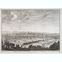
Veduta di Firenze dal Convento de P.P. Cappuccini di Montughi.
Distant view of the city of Florence in Tuscany region; seen from the north from the Capuchin convent at Montughi, after Giuseppe Zocchi (1711or 1717 - 1767) and engraved...
Date: Florence, Bouchard, 1754
Selling price: ????
Please login to see price!
Sold in 2016
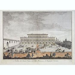
Veduta del Reale Palazzo dé Pitti Abitazione dé Regnanti Sovrani.
Lively view of a square with a Palace in Florence after Giuseppe Zocchi (1711or 1717 - 1767) and engraved by Johan Sebastian Muller of Nuremberg. From "Scelta di XXI...
Date: Florence, Bouchard, 1754
Selling price: ????
Please login to see price!
Sold in 2021
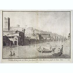
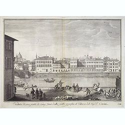
Veduta di una parte di Firenze presa fuori della Porta alla Croce presso al Fiume Arno.
Lively view of one of the entrance gates of Florence after Giuseppe Zocchi (1711or 1717 - 1767) and engraved by Carlo Gregori (1719-1759). From "Scelta di XXIV Vedut...
Date: Florence, Bouchard, 1754
Selling price: ????
Please login to see price!
Sold in 2014
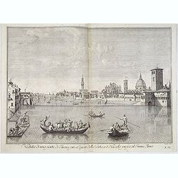
Veduta di una parte di Firenze presa fuori della Porta a S.Niccolo presso al Fiume Arno.
Lively view of one of the entrance gates of Florence after Giuseppe Zocchi (1711or 1717 - 1767) and engraved by B.Sgrilli. From "Scelta di XXIV Vedute delle principa...
Date: Florence, Bouchard, 1754
Selling price: ????
Please login to see price!
Sold
Veduta di una parte di Firenze presa della Vaga Loggia.
Lively view of one of the entrance gates of Florence after Giuseppe Zocchi (1711or 1717 - 1767) and engraved by Antonio Pazzi. From "Scelta di XXIV Vedute delle prin...
Date: Florence, Bouchard, 1754
Selling price: ????
Please login to see price!
Sold in 2014
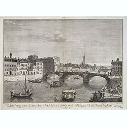
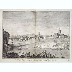
Veduta di una parte di Lung'Arno e del Ponte a S. Trinita presa dal Palazzo del Sig. March. Ruberto Capponi.
Lively view of St. Trinita bridge in Florence after Giuseppe Zocchi (1711or 1717 - 1767) and engraved by V.Francesschini. From "Scelta di XXIV Vedute delle principal...
Date: Florence, Bouchard, 1754
Selling price: ????
Please login to see price!
Sold in 2018
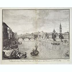
Veduta di Lung'Arno e del Ponte a S. Trinita presa dal Terrazzo de' SS.ri Rucellai.
Lively view of St. Trinita bridge in Florence after Giuseppe Zocchi (1711or 1717 - 1767) and engraved by Johann Sebastian Muller. From "Scelta di XXIV Vedute delle p...
Date: Florence, Bouchard, 1754
Selling price: ????
Please login to see price!
Sold
Veduta di una parte di Lung'Arno dalla parte opposta al Palazzo del Sig. P. Corsini.
Lively view of a canal in Florence after Giuseppe Zocchi (1711or 1717 - 1767) and engraved by Antonio Pazzi. From "Scelta di XXIV Vedute delle principali contrade, p...
Date: Florence, Bouchard, 1754
Selling price: ????
Please login to see price!
Sold in 2019
Veduta del Ponte a S. Trinita, della Chiesa di S. Trinita e della colonna inalzata da Cosimo I.
Lively street scene with the S.Trinita bridge in Florence after Giuseppe Zocchi (1711or 1717 - 1767) and engraved by Johan Andreas Pfeffel (1674-1748). From "Scelta ...
Date: Florence, Bouchard, 1754
Selling price: ????
Please login to see price!
Sold
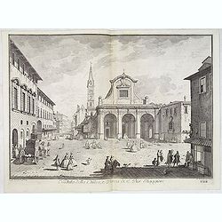
Veduta della Chiesa, e Piazza di S. Pier Maggiore.
Lively view of the Church and square San Pier Maggiore in Florence after Giuseppe Zocchi (1711or 1717 - 1767) and engraved by P. Monacus. From "Scelta di XXIV Vedute...
Date: Florence, Bouchard, 1754
Selling price: ????
Please login to see price!
Sold in 2018
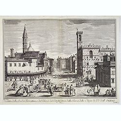
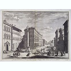
Veduta della Badia Fiorentina, e del Palazzo del Potestà presa dalla Piazza della Chiesa de' PP. dell'Oratorio.
Lively street scene with the palaces of the Major of Florence after Giuseppe Zocchi (1711or 1717 - 1767) and engraved by Vincenco Francesschini. From "Scelta di XXIV...
Date: Florence, Bouchard, 1754
Selling price: ????
Please login to see price!
Sold

Veduta degli Ufizi, o sia Curia Fiorentina presa dalla Loggia presso Arno.
Lively scene showing Uffizi Gallery in central Florence, one of the oldest and most famous art museums of the Western world. After Giuseppe Zocchi (1711or 1717 - 1767) an...
Date: Florence, Bouchard, 1754
Selling price: ????
Please login to see price!
Sold

Veduta della Metropolitana Fiorentina, e del Battistero di S. Gio. con la Processione del Corpus Domini.
Lively scene showing the Basilica di Santa Maria del Fiore in central Florence, showing a procession on the square and the Battistero of San Giovanni to the right. After ...
Date: Florence, Bouchard, 1754
Selling price: ????
Please login to see price!
Sold
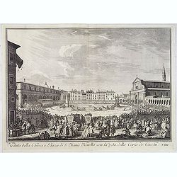
Veduta della Chiesa e Piazza di S. Maria Novella con la festa della Corsa de' Cocchi.
Lively scene showing the square di Santa Maria Novella in central Florence, showing a horse racing scene in the center. After Giuseppe Zocchi (1711or 1717 - 1767) and eng...
Date: Florence, Bouchard, 1754
Selling price: ????
Please login to see price!
Sold
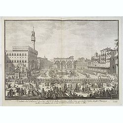
Veduta del Palazzo Vecchio del P.D. della Loggia e della Piazza con la Festa degli Omaggi nella solennità di S. Gio. Battista protettore della Città.
Lively scene showing the central square of Florence, showing a horse parade in the center. After Giuseppe Zocchi (1711or 1717 - 1767) and engraved by Carlo Gregori (1719-...
Date: Florence, Bouchard, 1754
Selling price: ????
Please login to see price!
Sold
Veduta della Chiesa, e Piazza di S. Croce con la festa del Calcio fatta l'anno 1738 alla Real presenza de' Regnanti Sovrani.
Lively scene showing the Piazza Santa Croce, one of the main squares of the center of Florence. To the right the Santa Croce church before it was rebuild in 1863.After Gi...
Date: Florence, Bouchard, 1754
Selling price: ????
Please login to see price!
Sold

(Title page) Scelta di XXIV Vedute delle principali contrade, piazze, chiese, e palazzi della Città di Firenze. . .
Title page from "Scelta di XXIV Vedute delle principali contrade, piazze, chiese, e palazzi della Città di Firenze" Engraved by Johan Gottfried Seutter after a...
Date: Florence, Bouchard, 1754
Selling price: ????
Please login to see price!
Sold
2e. Carte D'Afrique.
A map of Africa, engraved by J. Gibson, from Atlas Methodique by Jean Palairet, published by Nourse Vaillant.
Date: London, 1754
Selling price: ????
Please login to see price!
Sold in 2013

Hoxton Hospitall.
A fine 18th century copper engraving by Johannes Kip, featuring a view of Hoxton Hospital or Aske's Hospital on Pitfield Street in London. It was published according to A...
Date: London, 1754
Selling price: ????
Please login to see price!
Sold in 2015
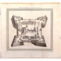
Fort Hollandois de L'Isle de Banda.
Striking view of Fort Nassau Banda which is on the Maluku Islands in Indonesia. The fortification view is from "HISTOIRE GENERALE DES VOYAGES". Jacques Nicola...
Date: Paris, 1754
Selling price: ????
Please login to see price!
Sold in 2014
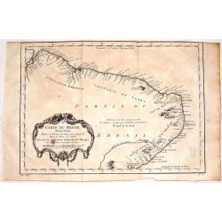
Carte du Bresil, Prem. Partie.
Fine copper engraving of the shoreline of Brasil from the Amazon River to the Bay of All Saints. Decorated by a large floral cartouche. Jacques Nicolas Bellin (1703–17...
Date: Paris, 1754
Selling price: ????
Please login to see price!
Sold in 2017

An exact Survey of the Cities of London and Westminster, the Borough of Southwark, The Country near ten Miles round begun in 1741, finished in 1745, and publish'd in 1746. . .
Key wall-map of the greater London area surveyed by John Rocque and published in 16 sheets. One of the finest maps of – what is now – Greater London ever produced. Ac...
Date: London, 1751/1754
Selling price: ????
Please login to see price!
Sold in 2014
Poland Lithuania and Prussia.
Nice example of Bowen's map of Poland and Lithuania.
Date: London, 1752-1754
Selling price: ????
Please login to see price!
Sold in 2015
Kaart der nieuwe ontdekkingen benoorden de Zuyd Zee zo wel ten oosten van Siberien en Kamtschatka als ten westen van Nieuw Vrankrijk
A uncommon Dutch edition of this landmark map in the history of northwestern cartography, charting the common boundaries of North America, Asia and the fictitious "M...
Date: Haarlem, 1754
Selling price: ????
Please login to see price!
Sold in 2015
Comtes de Hainaut et de Cambresis.
Large copperplate map of parts of Belgium and France including the counties of Hainaut, Cambrai, Flanders, Brabant and Namur. It was published by Robert de Vaugondy.
Date: Paris, 1754
Selling price: ????
Please login to see price!
Sold in 2016
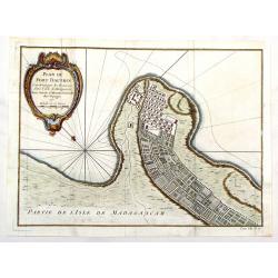
Plan du Fort Dauphin, Constuit par les François.
Fine copper engraved, hand colored map of Fort Dauphin on the Island of Madagascar of the east coast of Africa. After N. Bellin and engraved by van Schley. Features a bea...
Date: Paris, 1754
Selling price: ????
Please login to see price!
Sold in 2017
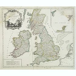
Les Isles Britanniques. . .
Decorative map of British Isles with Rococo title cartouche and inset map with Shetland Islands.
Date: Paris, 1754
Selling price: ????
Please login to see price!
Sold in 2015
Suite de la Carte de la Siberie et le Pays de Kamtschatka pour l'Histoire Generale des Voyages.
A striking map of eastern Siberia above and below the Arctic Circle, showing the Sea of Okhotsk, the Kamtschatka Peninsula, and Sakhalin Island. The map is from Bellin�...
Date: Paris, 1754
Selling price: ????
Please login to see price!
Sold in 2016
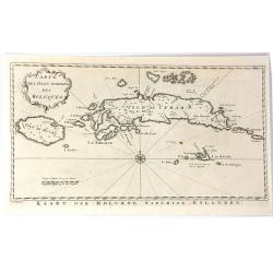
Carte des isles voisines des Moluques
A striking antique map of the Ceram, Ambon and the Banda islands close to Indonesia. Published by Antonine de Prevost d' Exile's “Histoire Generale des Voyages”. (Fro...
Date: Amsterdam, 1754
Selling price: ????
Please login to see price!
Sold in 2019
2e. Carte de France
A pleasant minimalistic map of France, featuring the French provinces and the capital of each, but with very little detail. It was engraved by Thomas Kitchin, and is date...
Date: London, 1754
Selling price: ????
Please login to see price!
Sold in 2016
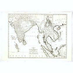
A Map of the East Indies from the latest Authorities and Observations....
Uncommon detailed map of South East Asia, India, and part of China, extending to Tibet, the Maladies, Sumatra, part of Borneo, Hainan, Kanton, etc.In upper right inset of...
Date: London, 1754
Selling price: ????
Please login to see price!
Sold in 2017
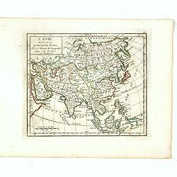
L'Asie Divisée selon ses differens Etats.
Small detailed map of Asia. From Atlas Portatif Universel, by Robert de Vaugondy.Page 160 outside border top right. State 2, title changed: "Par le Sr. Robert de Vau...
Date: Paris, 1754
Selling price: ????
Please login to see price!
Sold in 2017