Browse Listings
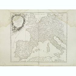
Imperium Caroli Magni Occidentis Imperatoris. . .
Attractive and detailed map of Charlemagne's empire, covering the British Isles, Denmark, the Low Countries, Germany, France, Spain, Switzerland, Austria, Italy, Hungary,...
Date: Paris, 1752
Selling price: ????
Please login to see price!
Sold in 2011
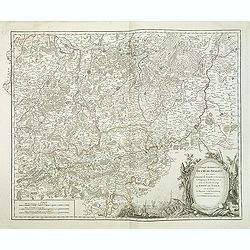
Partie Meridion. du Duche de Brabant. . .
Detailled map of a part of Belgique from his "Atlas Universel".Gilles Robert de Vaugondy (1688–1766), also known as Le Sieur or Monsieur Robert, and his son, ...
Date: Paris, 1752
Selling price: ????
Please login to see price!
Sold in 2013
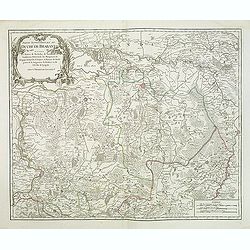
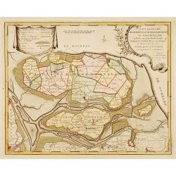
Partie septentrionale du duche de Brabant
A handsome map of Noord Brabant from his "Atlas Universel." Gilles Robert de Vaugondy (1688–1766), also known as Le Sieur or Monsieur Robert, and his son, Did...
Date: Paris, 1752
Selling price: ????
Please login to see price!
Sold in 2011
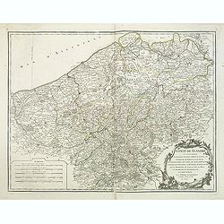
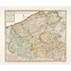
Comté de Flandre. . .
Detailled map of Flanders from his "Atlas Universel", with the privilege.Gilles Robert de Vaugondy (1688–1766), also known as Le Sieur or Monsieur Robert, and...
Date: Paris, 1752
Selling price: ????
Please login to see price!
Sold in 2011
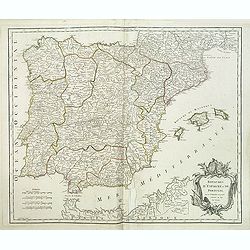
Royaumes d'Espagne et de Portugal.
Detailed map of Spain, Portugal and Baleares islands. Showing also south part of Franc and north Africa from his "Atlas Universel".Gilles Robert de Vaugondy (16...
Date: Paris, 1752
Selling price: ????
Please login to see price!
Sold in 2015
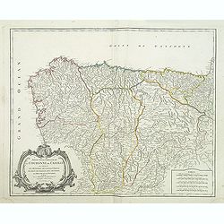
Partie septentrionale de la Couronne de Castille.
Detailed map of the northern part of Spain. Also depicting a small part of northern Portugal from his "Atlas Universel." Gilles Robert de Vaugondy (1688–1766)...
Date: Paris, 1752
Selling price: ????
Please login to see price!
Sold in 2011
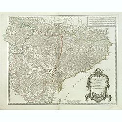
Etats de la Couronne d'Aragon. . .
Decorative map of the Kingdom of Aragon, with cartouche and coat of arms. Numerous place-names of counties, cities, towns, physical features from his "Atlas Universe...
Date: Paris, 1752
Selling price: ????
Please login to see price!
Sold in 2015
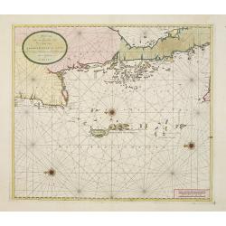
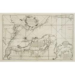
Carte Reduite, des Cotes De L'Acadie, de L'Isle Royale, et de la Partie Meridionale de L'Isle de Terre Neuve.
An important chart of Nova Scotia, southern Newfoundland and the Grand Banks, prepared after Chabert's voyage to Canada to update the French charts of Eastern Canada. It ...
Date: Paris, 1753
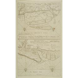
Kaarte der ..Noordbeveland, Wolphartsdyk en Oostbeveland..
Detailed map prepared by D.W.C. Hattinga in 1751. Isaac Tirion was born in Utrecht ca. 1705. He came to Amsterdam ca. 1725. Tirion published a number of important books, ...
Date: Amsterdam 1753
Selling price: ????
Please login to see price!
Sold
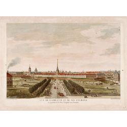
Vue de l'Amirauté et de ses environs.
Fine view of the admiralty buildings in St.Petersburg. Drawn and engraved under the direction of the imperial Academy of sciences and arts of Russia. After a design by De...
Date: Saint-Petersburg 1753
Selling price: ????
Please login to see price!
Sold
Nieuwe kaart van het Graafschap Vlaanderen, Artois. . .
Detailed map of western part of present day Belgium. Published by Isaäk Tirion in deLuxe edition of "Handatlas der geheele Aarde", Amsterdam, 1753.
Date: Amsterdam, 1753
Selling price: ????
Please login to see price!
Sold in 2020
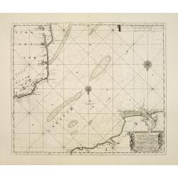
Aftekening van het Margat.. / Afteekening van de Rivier Cly en Blakeny geleegen aan de Oostkust van Engeland..
Latitude scale, compass rose and system of rhumb lines, soundings, anchorage's, etc. A wealth of cities and information appear in the chart.
Date: Amsterdam 1753
Selling price: ????
Please login to see price!
Sold
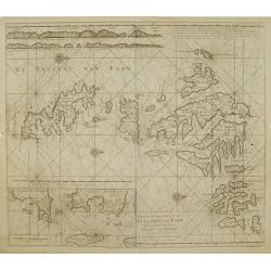
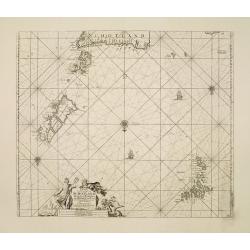
Nieuwe afteekening van de Eylanden van Fero..
Very rare: included in 6th volume, so-called secret atlas of the V.O.C. of Van Keulen. Latitude scale, compass rose and system of rhumb lines, soundings, anchorage's, etc...
Date: Amsterdam 1753
Selling price: ????
Please login to see price!
Sold
De Reede van \'t Leith van Edenburgh. / Afteekening van Nieuw en Oud Aberdeene ..
Latitude scale, compass rose and system of rhumb lines, soundings, anchorage\'s, etc. A wealth of cities and information appear in the chart. In upper right corner inset ...
Date: Amsterdam 1753
Selling price: ????
Please login to see price!
Sold
Afteekening van Scarbough Wicke.. / Afteekening van Hartlepoole ..
Latitude scale, compass rose and system of rhumb lines, soundings, anchorage\'s, etc. A wealth of cities and information appear in the chart.
Date: Amsterdam 1753
Selling price: ????
Please login to see price!
Sold in 2009
A new-enereasing Compass Map of part of the east coast of England..
Latitude scale, compass rose and system of rhumb lines, soundings, anchorage's, etc. A wealth of cities and information appear in the chart.The address is now updated to ...
Date: Amsterdam 1753
Selling price: ????
Please login to see price!
Sold in 2008
De Oost zee of Öster Siöön.
Latitude scale, compass rose and system of rhumb lines, soundings, anchorage's, etc. A wealth of cities and information appear in the chart.Printed on two joined sheets o...
Date: Amsterdam 1753
Selling price: ????
Please login to see price!
Sold
Vlakke hoek van Sumatra.
Showing the part of the west coast of Sumatra with the island of Enggano. Very rare: included in 6th volume, so-called secret atlas of the V.O.C. of Van Keulen. Latitude ...
Date: Amsterdam 1753
Selling price: ????
Please login to see price!
Sold
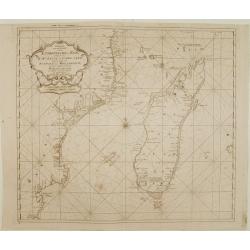
Paskaart van een gedeelte van de Aethiopische=Zee.. Madagascar..
Showing the island of Madagascar and the east coast of Africa. Very rare: included in 6th volume, so-called secret atlas of the V.O.C. of Van Keulen. Latitude scale, comp...
Date: Amsterdam 1753
Selling price: ????
Please login to see price!
Sold
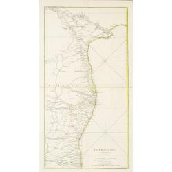
COROMANDEL.
A large map showing the east coast of the Indian peninsular.
Date: Paris, 1753
Selling price: ????
Please login to see price!
Sold in 2022
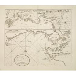
Afteekening van een gedeelte van de kust van Arracam, Pegu en Siam van de rivier Arracam, tot aan de Noordhoek van 't Eyland Sumatra.
Very rare chart of the Andaman Sea and Strait of Malacca. East to the top. In the top the town of Pegu in Miyanmar is shown, than the chart follows the coast of Thailand ...
Date: Amsterdam 1753
Selling price: ????
Please login to see price!
Sold
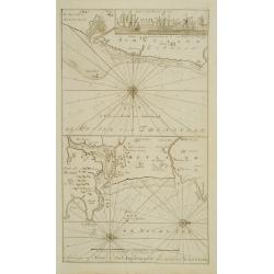
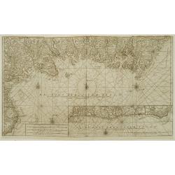
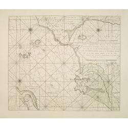
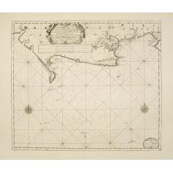
De rivier van Kingsale is geleegen aan de zuyd kust van Irland..
Latitude scale, compass rose and system of rhumb lines, soundings, anchorage's, etc. A wealth of cities and information appear in the chart. Latitude scale, compass rose ...
Date: Amsterdam 1753
Selling price: ????
Please login to see price!
Sold
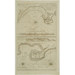
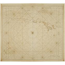
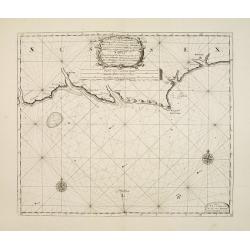
Nieuwe aftekening van Holy Eyland de Staples, coket Eyland en Barwyk .. Aan de ioostkust van Schotland..
Latitude scale, compass rose and system of rhumb lines, soundings, anchorage's, etc. A wealth of cities and information appear in the chart. Latitude scale, compass rose ...
Date: Amsterdam 1753
Selling price: ????
Please login to see price!
Sold in 2008
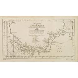
Paskaart Vande Noord Cust van Schotland als mede de Eylanden van Hitland en Fero..
South to the top. Latitude scale, compass rose and system of rhumb lines, soundings, anchorage's, etc. In lower right corner with added number 26.A wealth of cities and i...
Date: Amsterdam 1753
Selling price: ????
Please login to see price!
Sold in 2008
A new gradually encreasnig compass-map of the commingin of the Channel, or the Heads..
Title in Dutch, English and French. Showing the crossing of the Channel between Calais and Dover.Latitude scale, compass rose and system of rhumb lines, soundings, anchor...
Date: Amsterdam 1753
Selling price: ????
Please login to see price!
Sold
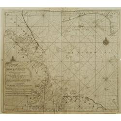
A new gradually encreasing compass-map, of a part the Sea Coasts of England .. Dorsetshire .. Hampshire ..
Title in Dutch and English. Showing the coasts of Dorset with Poole and Weymouth.Latitude scale, compass rose and system of rhumb lines, soundings, anchorage's, etc. In l...
Date: Amsterdam 1753
Selling price: ????
Please login to see price!
Sold
A new gradually encreasing compass-map, of a part the Sea Coasts of England .. Sussex .. Hastings to Arundel ..
Title in Dutch and English. Showing the coast of Sussex.Latitude scale, compass rose and system of rhumb lines, soundings, anchorage's, etc. In lower right corner with ad...
Date: Amsterdam 1753
Selling price: ????
Please login to see price!
Sold
Carte reduite du Détroit de Magellan..
A good engraved map of Strait of Magellan. The geographical features are typical with somewhat exaggerated bays and inlets. From l'Histoire générale des voyages .
Date: Paris 1753
Selling price: ????
Please login to see price!
Sold
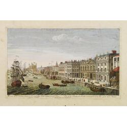
A View of the Custom House with part of the Tower taken from ye River Thames London.. Publish'd according to Act of Parliament 1753.
Very decorative, so-called optical print illustrating the river Thames with the Custom House with part of the Tower of London.In the eighteenth and nineteenth centuries t...
Date: London, 1753
Selling price: ????
Please login to see price!
Sold
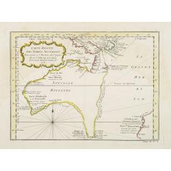
Carte réduite des Terres Australes..
A nice and decorative map showing the pre-Cook outline of Australia, with Van Diemenland still joined to the main island.Part of the coastline of New Zealand appears bott...
Date: Paris 1753
Selling price: ????
Please login to see price!
Sold
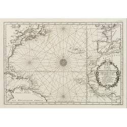
Karte von dem Abendlaendischen Ocean zur allgemeinen Historie der Reise beschreibungen entworfen von Hrn Bellin..
A nice and decorative map of the Atlantic Ocean.In: Allgemeine Historie der Reisen zur Wasser und zu Lande: oder Sammlung aller Reisebeschreibungen.. in Englischen zusamm...
Date: Leipzig, 1753
Selling price: ????
Please login to see price!
Sold
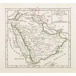
L'Arabie Par le Sr. Robert de Vaugondy.
Covering the Arabian Peninsula here called Arabie Heureuse . With title in upper left corner, the date 1748 erased. From his Atlas Portatif .
Date: Paris 1753
Selling price: ????
Please login to see price!
Sold
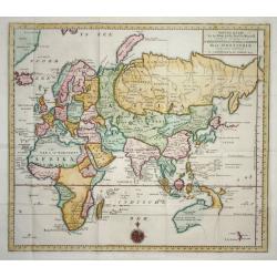
Nieuwe Kaart van het Oostelijkste Deel der Weereld
Finely engraved map of the Eastern Hemisphere provides an excellent view of the still evolving cartography of the Far East. The depiction of East Asia includes an extende...
Date: Amsterdam 1753
Selling price: ????
Please login to see price!
Sold
![Nieuwe Caart [..] van Banca langs [..] Malacca, Siam, Cambodia, Conchinchina](/uploads/cache/23814-250x250.jpg)
Nieuwe Caart [..] van Banca langs [..] Malacca, Siam, Cambodia, Conchinchina
A finely engraved and detailed chart of Malacca, with Singapore, Cambodia, Thailand and part of Borneo, Philippines, and many other islands in the South China Sea.Very ra...
Date: Amsterdam, 1753
Selling price: ????
Please login to see price!
Sold in 2008
![Pas=Kaart van de Vaarweg van Straat BANCA [?] en SINCAPOERA ..](/uploads/cache/23815-250x250.jpg)
Pas=Kaart van de Vaarweg van Straat BANCA [?] en SINCAPOERA ..
A finely engraved and detailed chart of southern tip of Malacca, with Singapore.Very rare: only included in 6th volume (so-called secret atlas) of Van Keulen's. Latitude ...
Date: Amsterdam 1753
Selling price: ????
Please login to see price!
Sold
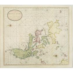
Nieuwe Afteekening van de PHILIPPYNSE EYLANDEN geleegen in de Oost-Indische Zee tusschen Formosa en Borneo.
A finely engraved and detailed chart of the Philippines.Very rare: only included in 6th volume (so-called secret atlas) of Van Keulen's. Latitude scale, compass rose and ...
Date: Amsterdam, 1753
Selling price: ????
Please login to see price!
Sold in 2008
![[2 charts] Nieuwe aftekening van de Baay MANILLA in de Oostindische Zee.. / Kaart van de baay van Bongo onder 't Eilandt MINDANO..](/uploads/cache/23817-250x250.jpg)
[2 charts] Nieuwe aftekening van de Baay MANILLA in de Oostindische Zee.. / Kaart van de baay van Bongo onder 't Eilandt MINDANO..
Two finely engraved and detailed charts of the Bay of Manila and the coast of Mindanao with the island Bongo.Very rare: only included in 6th volume (so-called secret atla...
Date: Amsterdam 1753
Selling price: ????
Please login to see price!
Sold in 2009
![Nieuwe Pas=Caart strekkende van Pta Cataon tot Pta. Lamtoan, langs de kusten van Cochinchina, Tonquin, Quangsi en Quantung [?] van Macao.](/uploads/cache/23818-250x250.jpg)
Nieuwe Pas=Caart strekkende van Pta Cataon tot Pta. Lamtoan, langs de kusten van Cochinchina, Tonquin, Quangsi en Quantung [?] van Macao.
A finely engraved and detailed chart of Vietnam reaching till Macao and present-day Hong Kong..Very rare: only included in 6th volume (so-called secret atlas) of Van Keul...
Date: Amsterdam 1753
Selling price: ????
Please login to see price!
Sold
![[2 charts] Kaart van Pulo Condor, of het Eiland Condor.. / Paskaart van de Baay van Padaran op de Kust van Tsiompa..](/uploads/cache/23819-250x250.jpg)
[2 charts] Kaart van Pulo Condor, of het Eiland Condor.. / Paskaart van de Baay van Padaran op de Kust van Tsiompa..
Two finely engraved and detailed charts of Condor Island and the Bay of Pandaran.Very rare: only included in 6th volume (so-called secret atlas) of Van Keulen's. Latitude...
Date: Amsterdam, 1753
Selling price: ????
Please login to see price!
Sold in 2013
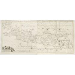
Insulae Iava Pars Occidentalis Edente Hadriano Relando..
Rare first state of this finely engraved and detailed map of Java important for its Dutch trading connections - annotated panels, clearly indicated rice fields, mountains...
Date: Amsterdam 1753
Selling price: ????
Please login to see price!
Sold
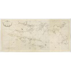
Zee-Caart van het Eyland Sumatra Met de Straaten Malacca, Sincapoera, Banca en Sunda..
A rare and finely engraved and detailed chart of Sumatra important for its Dutch trading connections. In upper right corner a detailed depiction of southern tip of Malays...
Date: Amsterdam 1753
Selling price: ????
Please login to see price!
Sold
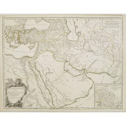
Antiquor? Imperiorum.. Marcedonium seu Alexandri..
Including the Arabian Peninsula here called Arabia Deserta. Good detail in Turkey and Egypt.Large inset shows northern India from the Indus River and the region of the As...
Date: Paris, 1753
Selling price: ????
Please login to see price!
Sold
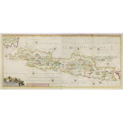
Insulae Java Pars Occidentalis Edente Hadriano Relando. . .
Very rare first state of this finely engraved and detailed map of Java important for its Dutch trading connections - annotated panels, clearly indicated rice fields, moun...
Date: Amsterdam, 1753
Selling price: ????
Please login to see price!
Sold in 2009
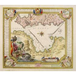
Plan du siege de Corfu par Terre et par Mer.
Uncommon map of the western coast of Corfu, including the town of Kérkira and its siege on July 5th, 1716. Upper part the coast of the Greek province of Sarande. Well-en...
Date: Nuremberg, 1753
Selling price: ????
Please login to see price!
Sold in 2010
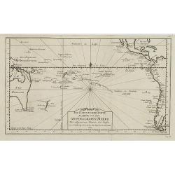
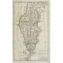
Neue und richtige Karte von dem Stillen Meere oder Mar der Sur . . . Pl.XXXVI.
Coastline map of Mexico starting from Acapulco and also including the Bay de San Francisco, the image oriented with East at the top of the image, which is largely of the ...
Date: Leipzig, 1753
Selling price: ????
Please login to see price!
Sold in 2015
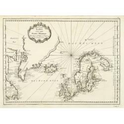
Karte von den Nord-Meeren zur allgemeinen Historie der Reisen...
Map of the North sea with coastlines of Greenland, Iceland and Norway. In: Allgemeine Historie der Reisen zur Wasser und zu Lande: oder Sammlung aller Reisebeschreibungen...
Date: Leipzig, 1753
Selling price: ????
Please login to see price!
Sold in 2011
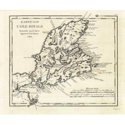
Karte von L'Isle Royale. . . . N°15.
Early map of Cape Breton Island - here called l'Isle Royale. An important island for the French as many strong holds were situated on the island. The most important was L...
Date: Leipzig, 1753
Selling price: ????
Please login to see price!
Sold in 2011
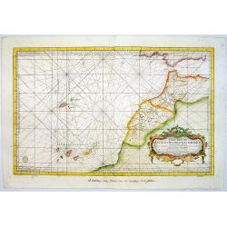
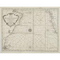
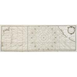
Carte Reduite Des Costes Occidentales D'Afrique Premiere Feuille contenant Les Costes de Barbarie depuis le Detroit de Gibraltar jusqu'au Cap Bojador Et Les Canaries . . . MDCCLIII
A well engraved and highly detailed of the Canary Islands, Madeira, from the Straits of Gibraltar to Cap Bojador, and the coast of Morocco. The chart shows soundings, an...
Date: Paris, 1753
Selling price: ????
Please login to see price!
Sold in 2015
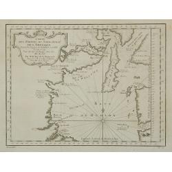
Carte Des Parties Du Nord-Ouest De L'Amerique . . .
Very nicely engraved chart that covers most of Hudson's Bay. Locates Fort Prince of Wales and Fort York, the Ottawa Islands (here the Bakers Dozen), the track of Henry El...
Date: Paris, 1753
Selling price: ????
Please login to see price!
Sold in 2011
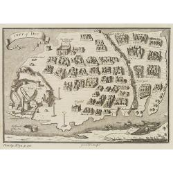
City of DIU.
Decorative town plan of Diu, after Joan Nieuhof. Engraved by G.Child for 'The Universal Traveller', by Thomas Salmon.
Date: London, Th. Salmon, 1729-1753
Selling price: ????
Please login to see price!
Sold in 2010
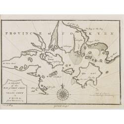
PROVINCE OF FOKYEN A chart of the Bay of Chin-Chew or Chang-Chew in China.
A small but very early and interesting map, engraved by G.Child for \'The Universal Traveller\', by Thomas Salmon.Covers that part of the coastline from Pu-tay Point, dow...
Date: London, Th. Salmon, 1729-1753
Selling price: ????
Please login to see price!
Sold in 2008
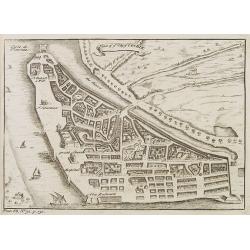
Plan of ye City of Cochin.
A small but very early and interesting town plan of Cochin, engraved by G.Child for 'The Universal Traveler', by Thomas Salmon.
Date: London, Th. Salmon, 1729-1753
Selling price: ????
Please login to see price!
Sold in 2012

Temple of Paulin near Nankin.
A small but very early and interesting engraving by J. Basire for 'The Universal Traveller', by Thomas Salmon. A pleasing and uncommon mid-18th century birds-eye view (li...
Date: London, Th. Salmon, 1729-1753
Selling price: ????
Please login to see price!
Sold in 2008
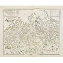
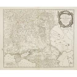
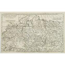
Partie Occidentale de l'Empire de Russie ou se trouve distinguée la Russie Européenne. . .
Detailed map of the European part of Russia.
Date: Paris, 1753
Selling price: ????
Please login to see price!
Sold in 2008
Partie Méridionale de la Russie Européenne . . .
Detailed map of Ukraine, the Crimea and the northern part of the Caspian Sea.
Date: Paris, 1753
Selling price: ????
Please login to see price!
Sold in 2009
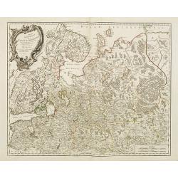
Partie Septentrionale de la Russie Européenne . . .
Detailed map of European part of Russia, including Finland, Lapland.
Date: Paris, 1753
Selling price: ????
Please login to see price!
Sold in 2008
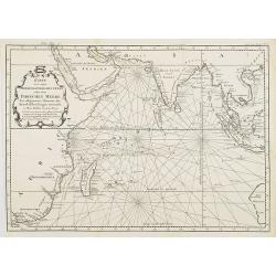
Karte von dem mittaeglichen Meere, zu der allgemeinen Historie der Reise beschreibungen entworfen von Hrn Bellin..
Detailed map of the Indian Ocean depicting incomplete coastline for Western Australia marked with "See hunden Bay" and "I.des Filles". Reaching in the...
Date: Leipzig, 1753
Selling price: ????
Please login to see price!
Sold in 2008
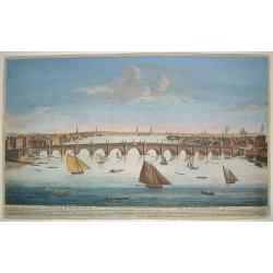
A View of Weftminfter Bridge / Vue du Pont de Weftminfter
A scarce, beautifully engraved view of Westminster Bridge and London. The work was originally executed by Boyer. Many key London sites are depicted in the background, inc...
Date: London, dated 1753
Selling price: ????
Please login to see price!
Sold in 2010
Karte von dem Abenlaendischen Ocean sur allgemeinen Historie der Reife beschreibungen entworfen von Hrn Bellin. . .
Map of the Atlantic Ocean with outlines of the North American continent and the European and African continents.In: Allgemeine Historie der Reisen zur Wasser und zu Lande...
Date: Leipzig, 1753
Selling price: ????
Please login to see price!
Sold in 2008
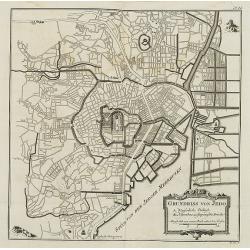
Grundriss von Jedo. . . N°24
City plan of the Emperor\'s Palace and the town of Jedo, Tokyo, Japan with a key to important buildings and bridges. In: Allgemeine Historie der Reisen zur Wasser und zu ...
Date: Leipzig, 1753
Selling price: ????
Please login to see price!
Sold in 2008
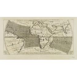
Vorstellung des ordentlichen Strichs der Gegenwinde, . . . N°16.
Map showing the winds in the Atlantic and Indian Oceans, centered on Africa, with part of Europe, South America and part of Asia in particular India. In: Allgemeine Histo...
Date: Leipzig, 1753
Selling price: ????
Please login to see price!
Sold in 2009
Karte von dem Mittaeglichen Meere zu der allgeinen Historie der Reis-beschreibungen. . .
Atlantic Ocean with coastlines of South America and Africa. In: Allgemeine Historie der Reisen zur Wasser und zu Lande: oder Sammlung aller Reisebeschreibungen.. in Engli...
Date: Leipzig, 1753
Selling price: ????
Please login to see price!
Sold in 2008
Neue und richtige Karte von dem Stillen Meere oder Mar der Sur . . . Pl.XXXVI.
Coastline map of Mexico starting from Acapulco and also including the Bay de San Francisco, the image oriented with East at the top of the image, which is largely of the ...
Date: Leipzig, 1753
Selling price: ????
Please login to see price!
Sold in 2008
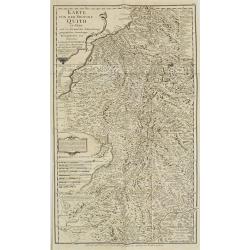
![Carte de la Meridiene mesurée au ROYAUME DE QUITO. . . [Karte von der Gemessenen Mittagslinie in dem Koenigreiche Quito. . .]](/uploads/cache/26172-250x250.jpg)
Carte de la Meridiene mesurée au ROYAUME DE QUITO. . . [Karte von der Gemessenen Mittagslinie in dem Koenigreiche Quito. . .]
A detailed map of Quito region, prepared in 1744. In: Allgemeine Historie der Reisen zur Wasser und zu Lande: oder Sammlung aller Reisebeschreibungen.. in Englischen zusa...
Date: Leipzig, 1753
Selling price: ????
Please login to see price!
Sold in 2009
In kleine gebrachte Karte von dem Mittaeglichen Meere . . .N°7.
Map of the Pacific and Oceania ocean from South America to Australia.In: Allgemeine Historie der Reisen zur Wasser und zu Lande: oder Sammlung aller Reisebeschreibungen.....
Date: Leipzig, 1753
Selling price: ????
Please login to see price!
Sold in 2008
Carte reduite de la Mer du Nord. . . / Zusammengezogene Karte des Nordmeeres. . .
Map of the North Atlantic Ocean. In: Allgemeine Historie der Reisen zur Wasser und zu Lande: oder Sammlung aller Reisebeschreibungen.. in Englischen zusammen getragen, un...
Date: Leipzig, 1753
Selling price: ????
Please login to see price!
Sold in 2008
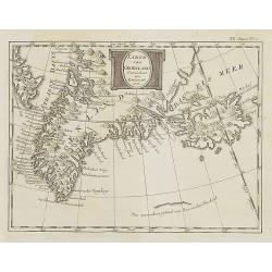
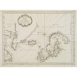
Karte von Groenland gezeichnet von Laurent 1770 . . . XX. Band N°1.
Map of Greenland and Iceland. In: Allgemeine Historie der Reisen zur Wasser und zu Lande: oder Sammlung aller Reisebeschreibungen.. in Englischen zusammen getragen, und a...
Date: Leipzig, 1753
Selling price: ????
Please login to see price!
Sold in 2008
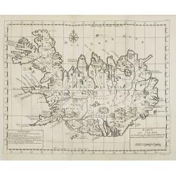
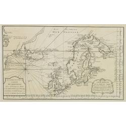
Karte von Island. . . N°1.
Map of Iceland. In: Allgemeine Historie der Reisen zur Wasser und zu Lande: oder Sammlung aller Reisebeschreibungen.. in Englischen zusammen getragen, und aus demselben u...
Date: Leipzig, 1753
Selling price: ????
Please login to see price!
Sold in 2008
Karte von Sibirien. . . N°4.
Map of Siberia. In: Allgemeine Historie der Reisen zur Wasser und zu Lande: oder Sammlung aller Reisebeschreibungen.. in Englischen zusammen getragen, und aus demselben u...
Date: Leipzig, 1753
Selling price: ????
Please login to see price!
Sold in 2009
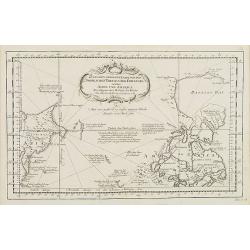
Zusammen Gezogene Karte von den Nordlichen Theilen der Erd-Kugel zwischen Asien und America. . . N°4.
Map of the Canadian Arctic regions with the eastern most Asian coastlines. In: Allgemeine Historie der Reisen zur Wasser und zu Lande: oder Sammlung aller Reisebeschreibu...
Date: Leipzig, 1753
Selling price: ????
Please login to see price!
Sold in 2009
Karte von den Nord-Meeren zur allgemeinen Historie der Reisen
Map of the North sea with coastlines of Greenland, Iceland and Norway. In: Allgemeine Historie der Reisen zur Wasser und zu Lande: oder Sammlung aller Reisebeschreibungen...
Date: Leipzig, 1753
Selling price: ????
Please login to see price!
Sold in 2008
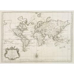
Versuch von einer kurzgefassten Karte welche die bekannten theile der Erdkugel . .
Map of the world with its five continents. In: Allgemeine Historie der Reisen zur Wasser und zu Lande: oder Sammlung aller Reisebeschreibungen.. in Englischen zusammen ge...
Date: Leipzig, 1753
Selling price: ????
Please login to see price!
Sold in 2008
KARTE von der Provinz Quito in Peru. . . N°8.
Detailed map of Peru. In: Allgemeine Historie der Reisen zur Wasser und zu Lande: oder Sammlung aller Reisebeschreibungen.. in Englischen zusammen getragen, und aus demse...
Date: Leipzig, 1753
Selling price: ????
Please login to see price!
Sold in 2009
Carte de la Mer du Sud ou Mer Pacifique. . . Page 305.
Detailed map of the Pacific Ocean from the Northern Marianas Islands to the Californian coastline. In: Allgemeine Historie der Reisen zur Wasser und zu Lande: oder Sammlu...
Date: Leipzig, 1753
Selling price: ????
Please login to see price!
Sold in 2009
KARTE von KAMTSCHATKA . . XX. Band N°8.
Detailed map of Kamtschtka. In: Allgemeine Historie der Reisen zur Wasser und zu Lande: oder Sammlung aller Reisebeschreibungen.. in Englischen zusammen getragen, und aus...
Date: Leipzig, 1753
Selling price: ????
Please login to see price!
Sold in 2009
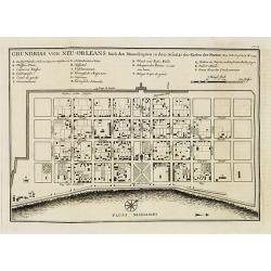
Grundriss von Neu-Orleans. . . N°18.
An important plan of New Orleans. In: Allgemeine Historie der Reisen zur Wasser und zu Lande: oder Sammlung aller Reisebeschreibungen.. in Englischen zusammen getragen, u...
Date: Leipzig, 1753
Selling price: ????
Please login to see price!
Sold in 2008
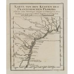
Karte von den Kpusten des Französischen Florida. . . N°3.
An important early city map of the South Carolina coast with Charlestown. In: Allgemeine Historie der Reisen zur Wasser und zu Lande: oder Sammlung aller Reisebeschreibun...
Date: Leipzig, 1753
Selling price: ????
Please login to see price!
Sold in 2008
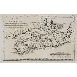
Karte von Accadia. . . N°2.
An important early map of Accadia and Isle Royale in Nova Scotia. Acadia (in the French language Acadie) was the name given to lands in a portion of the French colonial e...
Date: Leipzig, 1753
Selling price: ????
Please login to see price!
Sold in 2009
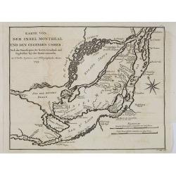
Karte von der insel Montreal und den degenden umher. . . N°5.
An important early map of the island and city of Montreal. In: Allgemeine Historie der Reisen zur Wasser und zu Lande: oder Sammlung aller Reisebeschreibungen.. in Englis...
Date: Leipzig, 1753
Selling price: ????
Please login to see price!
Sold in 2008
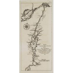
Karte von dem Flube Richelieu und dem See Champlain. . . N°IV.
An important early map of the Champlain River and its lake. In: Allgemeine Historie der Reisen zur Wasser und zu Lande: oder Sammlung aller Reisebeschreibungen.. in Engli...
Date: Leipzig, 1753
Selling price: ????
Please login to see price!
Sold in 2008