Browse Listings
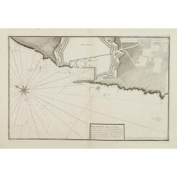
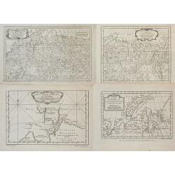
Plan du Port et Rade de Livourne..
Copper engraving centered on the harbour and roadstead of Livorno. Decorated with a large compass rose.From the rare chart book by Jacques Ayrouard: Recueil de plusieurs ...
Date: Marseille, 1732 - 1746
Selling price: ????
Please login to see price!
Sold in 2015
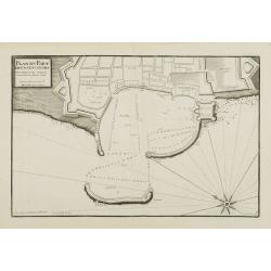
Plan du Port de Civita-Vechia. . .
Large plan of the harbour in Civitavecchia. Decorated with a large compass rose.From the rare chart book by Jacques Ayrouard: Recueil de plusieurs Ports .. de la Mer Méd...
Date: Marseille, 1732 - 1746
Selling price: ????
Please login to see price!
Sold in 2015
![[Untitled] Front views of the Italian coastal relief.](/uploads/cache/24848-250x250.jpg)
[Untitled] Front views of the Italian coastal relief.
Copper engraving presenting separate front views of the Tyrrhenian as well as Ionian coastal relief of Italy, divided in stripes.From the rare chart book by Jacques Ayrou...
Date: Marseille 1732 - 1746
Selling price: ????
Please login to see price!
Sold
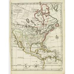
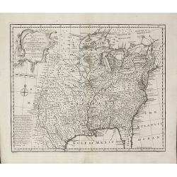
L'Amerique Septentrionale.
Interesting map of North America. In north eastern part of North America some interesting lakes and rivers are drawn, with a note: Terres vues par Tchirikow en 1741 . Tch...
Date: Paris, 1746
Selling price: ????
Please login to see price!
Sold in 2017
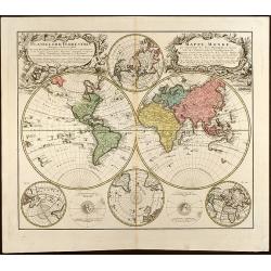
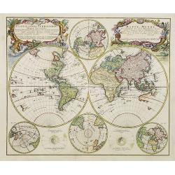
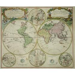
Planiglobii Terrestris Mappa Universalis Utrumq Hemisphaerium Orient et Occidentale repraesentans, Erx IV mappis generalibus Hasianis composita et adjectis ceteris hemisphaeriis designata a G.M. Lowizio. Excudentibus Homann Heredibus
Hand colored double hemisphere world map by J. M. Hase published by Homann Heirs showing also two circular charts of the North Pole and the South Pole and two small circu...
Date: Nuremberg, 1746
Selling price: ????
Please login to see price!
Sold in 2009
Planiglobii Terrestris Mappa Universalis.. - Mappe-Monde qui represente les deux Hemispheres..
Word map in double hemisphere. In centre two smaller hemispheres of the north and south pole are shown. Two interesting diagrams depict the earth as it would be seen from...
Date: Nuremberg, 1746
Selling price: ????
Please login to see price!
Sold
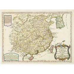
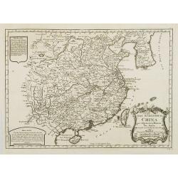
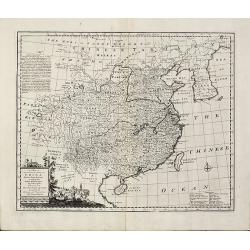
Das Kaiserthum China zur allgemeinen Historie der Reisen - entworfen von N. Bellin Ing. de la Mar. 1748.
Attractive and detailed map of China and Korea. The Sea of Japan is labeled "Das meer von Korea". The composition is nicely balanced with three decorative carto...
Date: Leipzig, Arkstee & Merkus, 1746
Selling price: ????
Please login to see price!
Sold in 2008
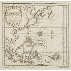
Fortsetzung der Karte von dem Morgenlaendischen Ocean die Eylande Sonda die Küsten von Tunquin und China die Eylande Japon.
Interesting and detailed map of Southeast Asia by Nicolas Bellin. Showing the Philippines, Indonesia, Japan, the east coast of China and parts of Papua New Guinea. With a...
Date: Leipzig, Arkstee & Merkus, 1746
Selling price: ????
Please login to see price!
Sold in 2009
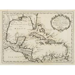
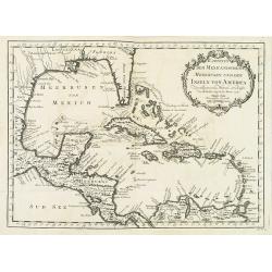
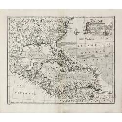
Karte von dem Mexicanischen Meerbusen und dem Inseln von America..
Fine map of the Caribbean, including Florida. From the German edition of Prevost's "L'Histoire Générale des Voyages" by J. J. Schwabe in Leipzig.Jacques Nicol...
Date: Leipzig, Arkstee & Merkus, 1746
Selling price: ????
Please login to see price!
Sold in 2008
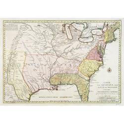
Karte von Luisiana, dem Laufe des Mississipi und den Benachbarten Laendern.
A rare German text edition of de l\'Isle\'s map of North America, focusing on the Mississippi and covering all the known United States, from the Rio del Norte (extending ...
Date: Leipzig, Arkstee & Merkus, 1746
Selling price: ????
Please login to see price!
Sold in 2008
![Ins Kleine Gebrachte Karte von den Sud-Laendern zur Histoire der Reisen. [Australia]](/uploads/cache/26065-250x250.jpg)
Ins Kleine Gebrachte Karte von den Sud-Laendern zur Histoire der Reisen. [Australia]
A uncommon map of Australia, one of the few 18th century maps concentrating on the Australian continent. With a reference noting a fictitious visit to south-west New Holl...
Date: Leipzig, Arkstee & Merkus, 1746
Selling price: ????
Please login to see price!
Sold in 2008
Lot of four maps showing Siberia and parts of Northern Russia.
Carte de la Siberie . ., 1754. Detailed overview of Siberia, showing cities, towns, mountainous and forested areas, and the region's numerous rivers. Route tracks of the...
Date: Paris, ca.1746
Selling price: ????
Please login to see price!
Sold in 2008
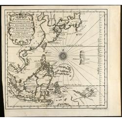
Fortsetzung der Karte von dem Morgenlaendischen Ocean die Eylande Sonda die Küsten von Tunquin und China die Eylande Japon
Interesting and detailed sea chart of Southeast Asia by Nicolas Bellin. Showing the Philippines, Indonesia, Japan, the east coast of China and parts of Papua New Guinea. ...
Date: Leipzig, 1746
Selling price: ????
Please login to see price!
Sold in 2010
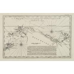
A Map of the Discoveries made by Capt.n Will.m Dampier in the Roebuck in 1699.
Uncommon and important map showing the New Britain Island in the Bismarck Sea. The map includes also the Indonesian island of Timor and surrounding islands, Irian Jaya an...
Date: London, 1746
Selling price: ????
Please login to see price!
Sold in 2009
Karte von Luisiana, dem Laufe des Mississipi und den Benachbarten Laendern.
A rare German text edition of de l'Isle's map of North America, focusing on the Mississippi and covering all the known United States, from the Rio del Norte (extending no...
Date: Leipzig, Arkstee & Merkus, 1746
Selling price: ????
Please login to see price!
Sold in 2015
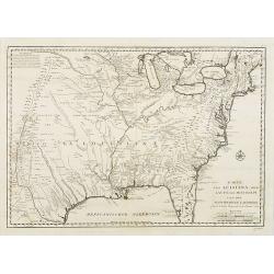
Amérique Septentrionale.
2 x 2 joined sheets.
Date: Paris, 1746
Selling price: ????
Please login to see price!
Sold in 2009
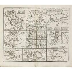
![[Untitled] Front views of the Spanish coastal relief.](/uploads/cache/28217-250x250.jpg)
[Untitled] Front views of the Spanish coastal relief.
Separate front views depicting great part of the Mediterranean coast of Spain, including Brescon, divided in stripes.It covers the littoral zone between Peñíscola and G...
Date: Marseille, 1732 - 1746
Selling price: ????
Please login to see price!
Sold in 2010
Das Kaiserthum China zur allgemeinen Historie der Reisen - entworfen von N. Bellin Ing. de la Mar. 1748.
Attractive and detailed map of China and Korea. The Sea of Japan is labeled "Das meer von Korea". The composition is nicely balanced with three decorative carto...
Date: Leipzig, Arkstee & Merkus, 1746
Selling price: ????
Please login to see price!
Sold
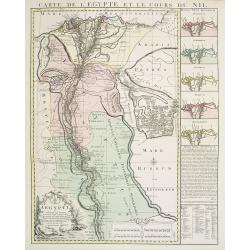
Carte de l'Egypte et le cours du Nil.
Large copper-engraved map illustrating the part of Egypt where the Nile River flows. Five insets on right margin depicting the river outfall according to Herodotum, Strab...
Date: Amsterdam c. 1746
Selling price: ????
Please login to see price!
Sold in 2016
Karte von dem Mexicanischen Meerbusen und dem Inseln von America..
Fine map of the Caribbean, including Florida. From the German edition of Prevost's "L'Histoire Générale des Voyages" by J. J. Schwabe in Leipzig.Jacques Nicol...
Date: Leipzig, Arkstee & Merkus, 1746
Selling price: ????
Please login to see price!
Sold in 2020
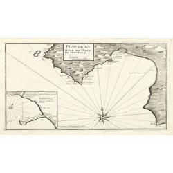
Plan de la Baye et Port de Mayorque. par Jacques Ayrouard pilote real et gravé par Louis Corne.
Large plan of the harbour Majorca. Decorated with a large compass rose.From the rare chart book by Jacques Ayrouard: "Recueil de plusieurs plans des ports et rades e...
Date: Marseille 1732-1746
Selling price: ????
Please login to see price!
Sold in 2010
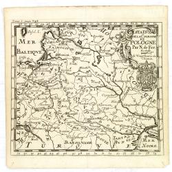
Estats de la Couronne de Pologne.
An interesting small map of the Poland by Nicolas de Fer. From Jacques Robbe’s "Methode pour Apprendre Facilement la Geographie". The map has a scale to 20 ho...
Date: Paris,1746
Selling price: ????
Please login to see price!
Sold in 2011
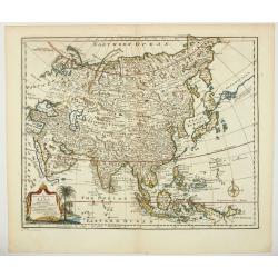
A new & accurate map of Asia drawn from actual surveys. . .
An excellent early engraving of Asia. Curious shape for Japan, with a large island north called Yeso and a coastline marked De Gamma's Land. Numbered "No 52."; ...
Date: London, 1747
Selling price: ????
Please login to see price!
Sold in 2024
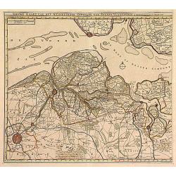
Nieuwe Kaart .. Westelykste Gedeelte van Staats-Vlaanderen
Detailed map of the Westerschelde delta, including Zeeuws Vlaanderen. Isaac Tirion was born in Utrecht ca. 1705. He came to Amsterdam ca. 1725. Tirion published a number ...
Date: Amsterdam 1747
Selling price: ????
Please login to see price!
Sold
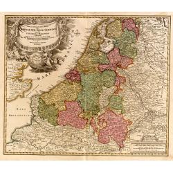
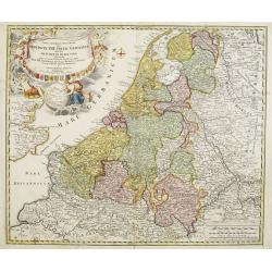
Tabula Generalis.. Provinciae XVII. Infer. Germaniae..
A decorative map with uncolored cartouche surrounded by the coats of arms of Brabant, Limburg, Luxembourg, Geldern, Holland, Zeeland, Zutphen, Flandria, Flanders, Artois,...
Date: Nuremberg 1747
Selling price: ????
Please login to see price!
Sold
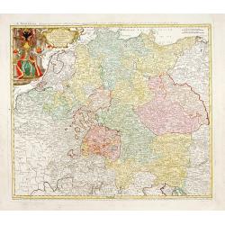
Imperii Romano Germanici..
Johann Baptist Homann's well-engraved map of the Roman Empire with a large decorative cartouche.
Date: Nuremberg, 1747
Selling price: ????
Please login to see price!
Sold
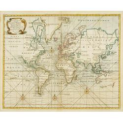
A new & correct chart of all the known world ..
World map according to Mercator?s Projection. From Harris, A compleat collection of Voyages and Travels..A great geographic blank, labelled Parts Undiscovered, occupies a...
Date: London 1747
Selling price: ????
Please login to see price!
Sold
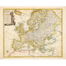
A new and very accurate map of Europe..
General map of Europe, with an elegant baroque title cartouche. Engraved by Emanuel Bowen. In lower left corner, plate number 36.
Date: London 1747
Selling price: ????
Please login to see price!
Sold
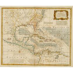
An accurate map of the WEST INDIES..
An excellent early engraving of the West Indies and including American east cost till Baltimore. Georgia occupies a very small area next to a large Florida. Numerous plac...
Date: London 1747
Selling price: ????
Please login to see price!
Sold
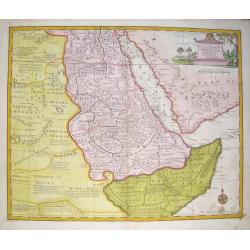
A New and Accurate Map of Nubia....
Folding page map showing area from lower Egypt, through Sudan and Ethiopia and down to Somalia. The map also includes the Red Sea and what is now Yemen and South Arabia. ...
Date: London 1747
Selling price: ????
Please login to see price!
Sold
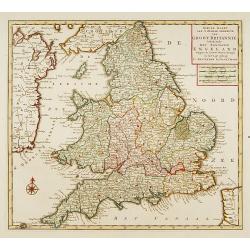
Nieuwe kaart van 'T zuider Gedeelte van Groot Brittannie. . .
Isaac Tirion was born in Utrecht ca. 1705. He came to Amsterdam ca. 1725. Tirion published a number of important books, many of which are still in demand for their intere...
Date: Amsterdam, 1747
Selling price: ????
Please login to see price!
Sold in 2023
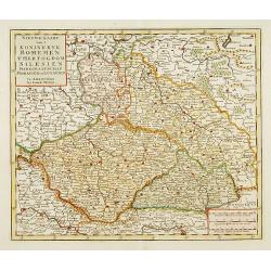
..Bohemen tHertogdom Silesien..Moravien en Lusatien.
Detailed map of Czech Republic. Including the towns of Berlin, Vienna, Regensburg. Isaac Tirion was born in Utrecht ca. 1705. He came to Amsterdam ca. 1725. Tirion publis...
Date: Amsterdam, 1747
Selling price: ????
Please login to see price!
Sold in 2015
![[No title] Gravenhage.](/uploads/cache/21302-250x250.jpg)
[No title] Gravenhage.
A very decorative panoramic view of the town, with detailed keys to the principal buildings and roads of the town.With dedication to Willem Carel Henderik Friso.Engraved ...
Date: The Hague 1747
Selling price: ????
Please login to see price!
Sold
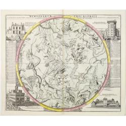
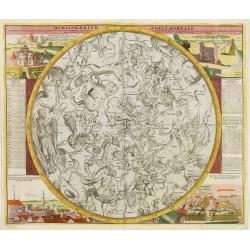
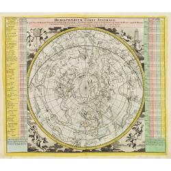
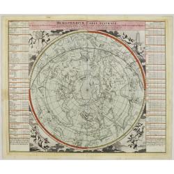
Hemisphaerium Coeli Australe
Magnificent celestial chart drawn by the famous scientist Johann Gabriel Doppelmayer. Large circular charts of the southern hemisphere constellation, with decorative vign...
Date: Nuremberg 1747
Selling price: ????
Please login to see price!
Sold
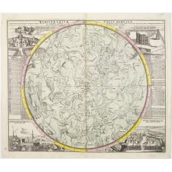
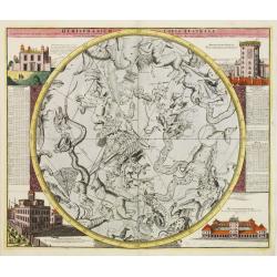
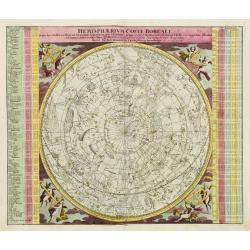
Hemisphaerium Coeli Boreale..
A magnificent celestial charts drawn by the famous scientist Johann Gabriel Doppelmayer. Large circular chart of the northern hemisphere constellations, with decorative v...
Date: Nuremberg 1747
Selling price: ????
Please login to see price!
Sold
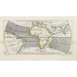
Die versinsterte Erdkugel.. Der sonnen od. Erd-finsternisden 25ten Jilli 1748.
A charming print showing a Sun disappearance calculated for July 25th 1748. With 3 hemisphere projections of Europe, Asia and Africa.Uncommon, with text in German, French...
Date: Nuremberg 1747
Selling price: ????
Please login to see price!
Sold
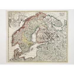
Scandinavia complectens Sueciae, Daniae & Norvegia..
Johann Baptist Homann's well-engraved map has a large decorative cartouche. Detailed map of Scandinavia.Johann Baptist Homann (1663-1724) was a German engraver and publis...
Date: Nuremberg 1747
Selling price: ????
Please login to see price!
Sold
A new & accurate chart of the world drawn from authentic..
Shows the world on Mercator's projection. The boundaries of both Australia and New Zealand are not yet completely defined. The northwest coast of North America and the su...
Date: London, 1747
Selling price: ????
Please login to see price!
Sold
Hemisphaerium Coeli Boreale in quo Fixarum..
A magnificent celestial charts drawn by the famous scientist Johann Gabriel Doppelmayer. Large circular chart of the northern hemisphere constellations, with decorative v...
Date: Nuremberg 1747
Selling price: ????
Please login to see price!
Sold
Hemisphaerium Coeli Australe in quo Fixarum..
Magnificent celestial chart drawn by the famous scientist Johann Gabriel Doppelmayer.Large circular charts of the southern hemisphere constellation, with decorative vigne...
Date: Nuremberg, 1747
Selling price: ????
Please login to see price!
Sold
Hemisphaerium Coeli Australe in quo loca Stellarum..
Magnificent celestial chart drawn by the famous scientist Johann Gabriel Doppelmayer.Large circular charts of the southern hemisphere constellation, with decorative vigne...
Date: Nuremberg 1747
Selling price: ????
Please login to see price!
Sold
Hemisphaerium Coeli Boreale in quo loca Stellarum..
Magnificent celestial chart drawn by the famous scientist Johann Gabriel Doppelmayer.Large circular charts of the northern hemisphere constellation, with decorative vigne...
Date: Nuremberg 1747
Selling price: ????
Please login to see price!
Sold
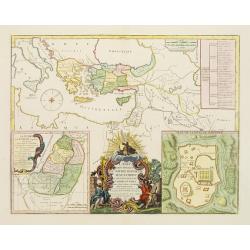
Carte des voyages de Notre seigneur Jesus Christ..
Showing eastern part of the Mediterranean, including Cyprus, Italy. Lower right hand corner inset plan of Jerusalem. Lower left map of Palestine. Published by Vaugondy, a...
Date: Paris, 1747
Selling price: ????
Please login to see price!
Sold in 2009
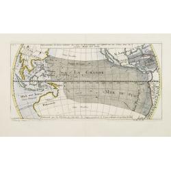
Répresentation du Cours ordinaire des Vents de Traverse qui regnent sur les Côtes dans la grande Mer Du Sud.
Sea chart of tides wind currents, centred on the equatorial regions of the South Pacific, from South America to Indochina. Published by Bellin in the Histoire Generale de...
Date: Paris, 1747
Selling price: ????
Please login to see price!
Sold
Representation du Cours ordinaire des Vents de Traverse qui regnent le long des Côtes dans la Mer Atlantique & celle des Indes.
A relatively early scientific map of the winds relating to the Atlantic and Indian oceans.Eight islands are named in the bottom margins which correspond to their location...
Date: Paris 1747
Selling price: ????
Please login to see price!
Sold
Hemisphaerium Coeli Australe in quo loca Stellarum..
Magnificent celestial chart drawn by the famous scientist Johann Gabriel Doppelmayr.Large circular charts of the southern hemisphere constellation, with decorative vignet...
Date: Nuremberg, 1747
Selling price: ????
Please login to see price!
Sold
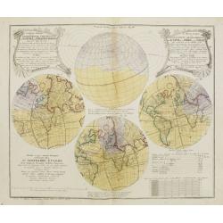
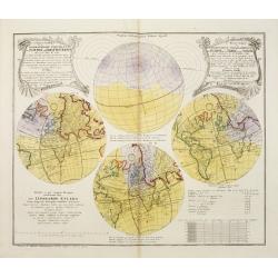
Le Monde Eclipsé ou.. Eclipse de la Terre ou du Soleil.. Premiere feuille.
Showing four hemispheric world maps showing the predicted eclipse of 1748, based upon the calculations of the important 18th Century Swiss mathematician and astronomer Le...
Date: Nuremberg, 1747
Selling price: ????
Please login to see price!
Sold
Provinciae XVII Infer Germaniae. . .
A decorative map with colored cartouche surrounded by the coats of arms of Brabant, Limburg, Luxembourg, Geldern, Holland, Zeeland, Zutphen, Flandria, Flanders, Artois, H...
Date: Nurember, 1747
Selling price: ????
Please login to see price!
Sold in 2008
![Hemisphaerium Coeli Australe [together with] . . . Coeli Boreale . . .](/uploads/cache/25375-250x250.jpg)
Hemisphaerium Coeli Australe [together with] . . . Coeli Boreale . . .
Magnificent set of celestial charts drawn by the famous scientist Johann Gabriel Doppelmayr. Large circular charts of the southern hemisphere constellation, with decorati...
Date: Nuremberg 1747
Selling price: ????
Please login to see price!
Sold in 2013
Planiglobii Terrestris. . .
Johann Baptist Homann's well-engraved double hemisphere world map has large decorative cartouches.Johann Baptist Homann (1663-1724) was a German engraver and publisher, w...
Date: Nuremberg, 1747
Selling price: ????
Please login to see price!
Sold in 2009
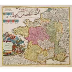
Totius Galliae sive Franciae tabula..
Johann Baptist Homann's well-engraved map of France has a large decorative cartouche and 12 coats of arms of different provinces. Detailed map centred on Venice. Johann B...
Date: Nuremberg, 1747
Selling price: ????
Please login to see price!
Sold
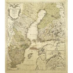
Svea och Göta Riken med Finland och Norland : afritade i Stockholm år 1747
A detailed and rare map of Sweden and Finland, published in Stockholm, 1747. In lower right a cartouche with the north of Norway.Engraved by George Biurman (1700-1755), w...
Date: Stockholm, 1747
Selling price: ????
Please login to see price!
Sold in 2010
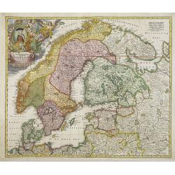
Scandinavia complectens Sueciae, Daniae & Norvegia. . .
Johann Baptist Homann's well-engraved map has a large decorative cartouche. Detailed map of Scandinavia.Johann Baptist Homann (1663-1724) was a German engraver and publis...
Date: Nuremberg, 1747
Selling price: ????
Please login to see price!
Sold in 2011
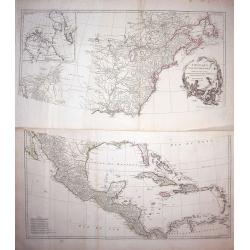
Particular Draughts and Plans of Some of the Principal Towns and Harbours Belonging to the English, French, and Spaniards, in America and West Indies
An unusual copper engraving by E. Bowen from 'A Complete System of Geography'. Featuring 13 small maps of colonial towns and sea ports of North America and the West Indie...
Date: London, 1747
Selling price: ????
Please login to see price!
Sold in 2010
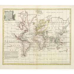
A New & Accurate Chart of the World
World map by Emanuel Bowen from 'A Complete System of Geography'. Showing the world in Mercator projection with isogonic lines. With one cartouche. New Zealand is largely...
Date: London, 1747
Selling price: ????
Please login to see price!
Sold in 2010
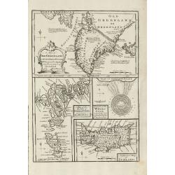
A Map of Old Greenland or Oster Bygd & Wester Bygd ... An Improved Map of Iceland ... A Map of the Islands of Ferro ... A Draught of the Whirlpool on the South East of Sumbo Rocks
An unusual copper engraving by E. Bowen from 'A Complete System of Geography'. Featuring 4 small maps of the North Atlantic Islands Greenland, Iceland and Faroe. A curios...
Date: London, 1747
Selling price: ????
Please login to see price!
Sold in 2011
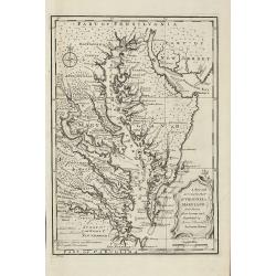
A New and Accurate Map of Virginia & Maryland. Laid Down from Surveys and Regulated by Astronl. Observatns
Scarce map of the Chesapeake region by Bowen from 'A Complete System of Geography'. Based on Hermann's map of 1673 and Popple's map of 1733. Showing numerous early towns ...
Date: London, 1747
Selling price: ????
Please login to see price!
Sold in 2010
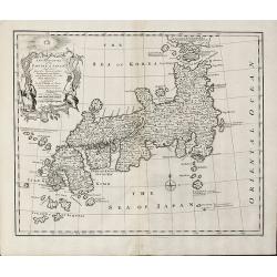
A New and Accurate Map of the Empire of Japan Laid down from the Memoirs of the Portuguese and Dutch and ... the Jesuit Missionaries
Bowen's map of Japan from 'A Complete System of Geography'. With an elaborate allegorical cartouche and a compass rose. The way in which the area to the north of Honshu i...
Date: London, 1747
Selling price: ????
Please login to see price!
Sold in 2011
A New & Accurate Map of China. Drawn from Surveys made by the Jesuit Missionaries, by Order of the Emperor
Bowen's map of China from 'A Complete System of Geography'. With an elaborate allegorical cartouche and a compass rose. Includes Korea and Formosa and advertising notes a...
Date: London, 1747
Selling price: ????
Please login to see price!
Sold in 2010
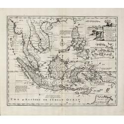
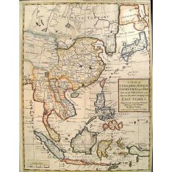
A New and Accurate Map of the East India Islands
Bowen's map of Southeast Asia from 'A Complete System of Geography'. With an elaborate allegorical cartouche and a compass rose. Includes the Philippines and part of Aust...
Date: London, 1747
Selling price: ????
Please login to see price!
Sold in 2010
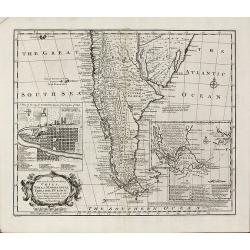
A New and Accurate Map of Chili, Terra Magellanica, Terra del Fuego &c
Bowen's map of the southern part of South America from 'A Complete System of Geography'. With one title cartouche and a compass rose. With two inset maps, one of Santiago...
Date: London, 1747
Selling price: ????
Please login to see price!
Sold in 2010
A New & Accurate Map of Louisiana, with Part of Florida and Canada, and the Adjacent Countries
Remarkable map of the British, Spanish & French Colonies in North America on the eve of the French & Indian War by E. Bowen from 'A Complete System of Geography'....
Date: London, 1747
Selling price: ????
Please login to see price!
Sold in 2011
A New and Accurate Map of New Jersey, Pensilvania, New York and New England with the Adjacent Countries
A scarce map of New Jersey, New York, Pennsylvania, Maine, New Hampshire and Connecticut by E. Bowen from 'A Complete System of Geography'. Covering the area from the Che...
Date: London, 1747
Selling price: ????
Please login to see price!
Sold in 2011
A New & Accurate Map of the Provinces of North & South Carolina Georgia &c
Bowen's map of the Carolinas and Georgia from 'A Complete System of Geography'. Showing the area from the mouth of the Chesapeake Bay to St. Augustine and from Louisiana ...
Date: London, 1747
Selling price: ????
Please login to see price!
Sold in 2012
An Accurate Map of the West Indies
Bowen's map of the West Indies from 'A Complete System of Geography'. Showing the area from Long Island in the north to the delta of the Orinoco in the south. Decorated w...
Date: London, 1747
Selling price: ????
Please login to see price!
Sold in 2011
Carte des voyages de Notre seigneur Jesus Christ. . .
Showing eastern part of the Mediterranean, including Cyprus, Italy. Lower right hand corner inset plan of Jerusalem. Lower left map of Palestine. Published by Vaugondy, a...
Date: Paris, 1747
Selling price: ????
Please login to see price!
Sold in 2011
A New and Accurate Map of Savoy, Piemont, and Montferrat Exhibiting the Present Seat of War. . .
An attractive map of the Savoy and Montferrat regions of southeastern France and the northern Italian region of Piedmont on the Mediterranean Sea coast by Emmanuel Bowen...
Date: London, 1747
Selling price: ????
Please login to see price!
Sold in 2010
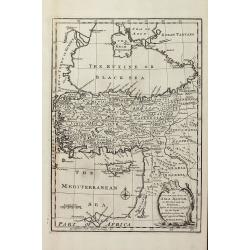
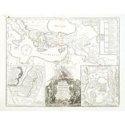
An Accurate Map of Asia Minor, as Divided into its Provinces, before it became Possess'd by the Turks
Engraved map of Turkey by Bowen from 'A Complete System of Geography'. Showing Asia Minor with the Black-sea region and the eastern part of the Mediterranean sea with Cyp...
Date: London, 1747
Selling price: ????
Please login to see price!
Sold in 2013
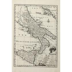
A New & Accurate Map of the Kingdoms of Naples & Sicily
Decorative engraved map of South Italy by Bowen from 'A Complete System of Geography'. Showing the southern part of Italy with Sicily. With one decorative cartouche, a co...
Date: London, 1747
Selling price: ????
Please login to see price!
Sold in 2011
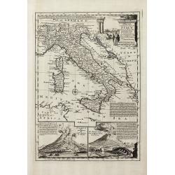
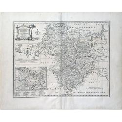
A New and Accurate Map of Italy Drawn from the Latest and Best Authorities, and Regulated by the Most Approved Astronl. Observations
Decorative engraved map of Italy by Bowen from 'A Complete System of Geography'. Below with to inset views of Mount Vesuvius eruptions. With one decorative cartouche, a c...
Date: London, 1747
Selling price: ????
Please login to see price!
Sold in 2013
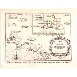
Partie de la Coste de Guinee Depuis le Cap de Monte Jusqu'au Cap des Basses.
Fine little map engraved by Schley featuring the coast of Guinee in Western Africa. The insert is of the Sestos River. Pleasing floral, title cartouche. The map was publi...
Date: Paris, 1747
Selling price: ????
Please login to see price!
Sold in 2015
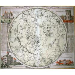
Hemisphaerium Coeli Australe...
Magnificent map of the southern hemisphere constellation for 1730, with celestial monsters and zodiac signs. With tables on the side giving information on the constellati...
Date: Nuremberg, 1747
Selling price: ????
Please login to see price!
Sold in 2011
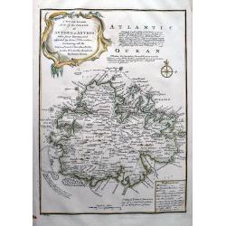
A New and Accurate Map of the Island of Antigua or Antego...
Highly attractive map of Antigua. Very detailed map with many place names, streets, etc. With text describing the island and a legend explaining symbols to churches, for...
Date: London, 1747
Selling price: ????
Please login to see price!
Sold in 2012
Charta öfwer Södermanland Med Kongl. Maj.ts. Nådigste privilegio utgifven af Kong:e Landtmäteri Contoiret.
A scarce map of the district of Södermanland, including Stockholm in Sweden. A large title cartouche upper right and a key in the upper left corner. The map is a part of...
Date: Stockholm, c.1747
Selling price: ????
Please login to see price!
Sold in 2012
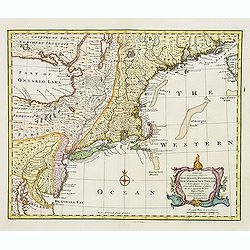
A new and accurate map of New Jersey, Pensilvania, New York and New England with the Adjacent Countries. . .
A scarce map of New Jersey, New York, Pennsylvania, Maine, New Hampshire and Connecticut. Canada extends south to the Pennsylvania border. Published by E. Bowen from &quo...
Date: London, 1747
Selling price: ????
Please login to see price!
Sold in 2018
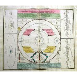
Theoria Satellitum Iovis et Saturni...
Magnificent chart of the satellite systems of Jupiter and Saturn compared with the Earth-Moon system according to the observations of Giovanni Domenico Cassini in Bologna...
Date: Nuremberg, 1747
Selling price: ????
Please login to see price!
Sold in 2012
![Kaartje Van TKeizer-Ryk China... [two maps]](/uploads/cache/92001-250x250.jpg)
Kaartje Van TKeizer-Ryk China... [two maps]
Two rare maps based on the work of De L'Isle, one of the Empire of China and a second of Chinese Tartary, including Korea and an oversized Hokkaido.
Date: Deventer, 1747
Selling price: ????
Please login to see price!
Sold in 2012
A Map of China, Japan, Tonquin, Cochin-China and Siam.
Uncommon map of South East Asia engraved by R.W. Seale.
Date: London, c. 1747
Selling price: ????
Please login to see price!
Sold in 2012
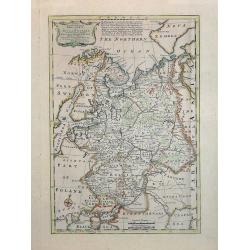
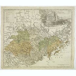
A New & Accurate map of MOSCOVY or Russia in Europe with its Aquisitions. . .
Decorative 1747 copper engraved map of Russia by Emanuel Bowen from "A Complete System of Geography". Showing the region from northern part of Norway to the Bla...
Date: London, 1747
Selling price: ????
Please login to see price!
Sold in 2013
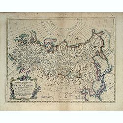
A New and Accurate Map of the Whole Russian Empire as contained both in Europe and Asia. . .
Detailed map of Russia, from the Sea of Anadyr, Sea of Kamchatka and the Kuril Islands to Poland. In the NW Coast of America references to Tschirikov's contact with Alask...
Date: London, c. 1747
Selling price: ????
Please login to see price!
Sold in 2013