Browse Listings

Imperium Ottomanno -Turcicum vel Turcarum posteriorum exhibens statum post pacem Passarovicensem.
Rare map of the Ottoman Empire, only known in one edition published in Haas's "Atlas historicus". This small but very detailed map extends from Spain and Morocc...
Place & Date: Nuremberg, Homann, c1746
Selling price: $120
Sold in 2014

King George I
Hand colored engraving by J. Houbraken, published in Amsterdam by J & P Knapton in 1746. King George I (1660-1727), reigned 1714-1727. The great-grandson of James I,...
Place & Date: Amsterdam, 1746
Selling price: $19
Sold in 2016
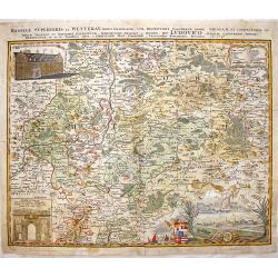
Hassiae Superioris et Wetterau, Paris Delineatio.
Copper engraving By Homann Heirs, dated 1746. Original hand coloring with recent coloring added to border & cartouches.Giessen is located in the center of this detail...
Place & Date: Nuremberg, 1746
Selling price: $60
Sold in 2017
A Map of London and the Adjacent Country 10 Miles Around - (Sheet 1 of 16).
This is a part of an exact Survey of the City of London Westminster, ye Borough of Southwark and the country near ten miles round, begun in 1741 and ended in 1745, by Joh...
Place & Date: London, 1746
Selling price: $25
Sold in 2020

Vue du Chateau Royal de Frederichsberg Vers la Cour.
A striking view of Fredericksberg Castle in Copenhagen. From "Den Danske Vitruvius", a richly illustrated 18th-century architectural work on Danish monumental b...
Place & Date: Germany, 1746
Selling price: $149
Sold in 2020
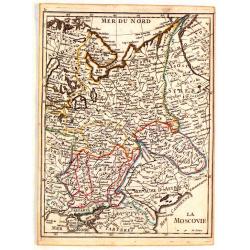
La Moscovie.
Fine original colored map of Russia in Europe by George Louis La Rouge.
Place & Date: Paris, 1746
Selling price: $16
Sold in 2015

Robert, Earl of Orford.
Striking hand-colored copper engraving featuring Robert Walpole, 1st Earl of Orford. Engraved by J. Houbraken from a painting by Pond in 1746. It was published by Knapton...
Place & Date: London, 1746
Selling price: $17
Sold in 2019
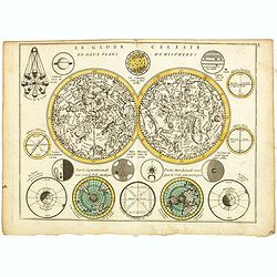
Le Globe Celeste en deux plans Hemispheres.
A very decorative double hemisphere celestial chart, centered on the North and South Poles, Saturn, Jupiter, Venus, Mars, Mercury and the Moon from the observations of Ca...
Place & Date: Paris, 1746
Selling price: $120
Sold in 2017
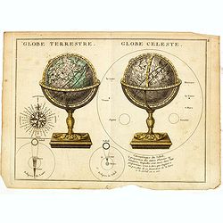
Globe Terrestre. / Globe Celeste.
A very decorative depiction of a terrestrial and celestial globe on a decorative base. To the left a compass card, 3 diagrams showing the sizes of the stars, the illumina...
Place & Date: Paris, 1746
Selling price: $25
Sold in 2023
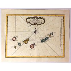
Carte Des Isles Canaries
Detailed map of the Canary Islands, with towns, ports, etc. Produced by Bellin, Ingenieur de la Marine, for Prevost d'Exiles important travel book, "L'Histoire Gener...
Place & Date: Paris, 1746
Selling price: $47
Sold in 2015
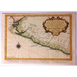
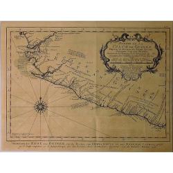
Partie de la Coste de Guinee, Depuis la Riviere de Sierra Leona Jusquan Cap das Palmas.
Detailed map of the Guinea coast in West Africa, from the Sierra Leone River to Cape Palmas on the southern coast of what is now Liberia, from the atlas of Prevost d'Exil...
Place & Date: Paris, 1746
Selling price: $25
Sold in 2017
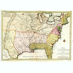
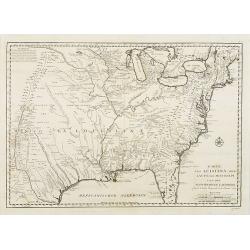
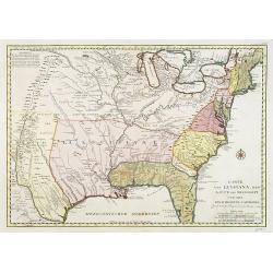
Karte von Luisiana, dem Laufe des Mississipi und den Benachbarten Laendern.
A rare German text edition of de l'Isle's map of North America, focusing on the Mississippi and covering all the known United States, from the Rio del Norte (extending no...
Place & Date: Leipzig, Arkstee & Merkus, 1746
Selling price: $1000
Sold in 2019
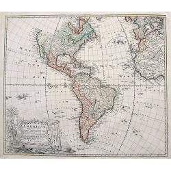
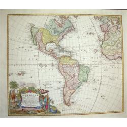
Americae Mappa generalis...
Important map of the Americas with contemporary hand color. Shows a partially unexplored Northwest. Locates Quivira, Tecas (Texas), and many native Indian areas. Indicate...
Place & Date: Nuremberg, 1746
Selling price: $325
Sold in 2018
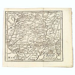
Mogol.
An attractive map of northern India with decorative cartouche, from 'Methode pour apprendre facilement la Geographie' by Jacques Robbe.small decorative title cartouche. W...
Place & Date: Paris, 1746
Selling price: $105
Sold in 2017
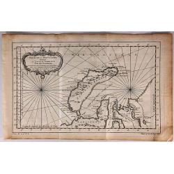
Partie de la Mer Glaciale Contenant la Nouvelle Zemble et le Pais des Samoiedes.
A detailed map of Nova Zembla and part of the northeast passage in northern Russia. It includes a decorative title cartouche. Produced by Bellin for the L'Histoire Genera...
Place & Date: Paris, 1746
Selling price: $10
Sold in 2018
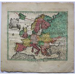
Novae Europae Delineatio.​
A decorative old colored copper engraved map by Peter Conrad Monath. This interesting map shows the continent of Europe with the Christian countries of Scandinavia, Great...
Place & Date: London, 1746
Selling price: $100
Sold in 2018
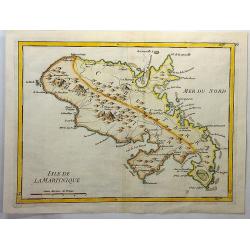
Isle de la Martinique.
An antique copperplate map featuring the French island of Martinique. In 1692, Charles de La Roche-Courbon, Count of Blénac, the Governor and Lieutenant General of the F...
Place & Date: Paris, 1746
Selling price: $41
Sold in 2021
Amerique Septentrionale Publiee sous les Auspices de Monseigneur le Duc d'Orleans Premier Prince du Sang. . .
A large map of North America and the West Indies that was one of the best French maps of North America prior to the French & Indian War. This map provides good inform...
Place & Date: Paris, 1746
Selling price: $1100
Sold in 2019
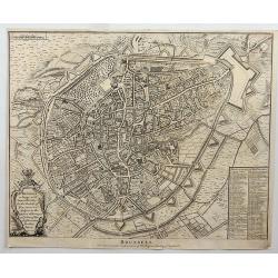
Brussels.
Fine detailed plan of the city of Brussels in Belgium, including fortifications, town plan, roads, farms, rivers and a decorative cartouche with arms, city crest and topp...
Place & Date: London, 1746
Selling price: $50
Sold in 2018
Partie de la Coste de Guinee Depuis la Riviere de Sierre Leona Jusquau Cap das Palmas . . .
The coasts of present-day Sierre Leone and Liberia in Western Africa are shown on this map. All along the coasts are depth sounds. The map features an attractive title ca...
Place & Date: Paris, 1746
Selling price: $35
Sold in 2019
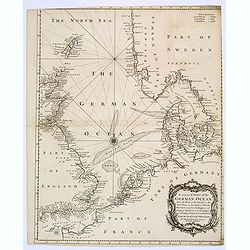
A correct Chart of the German Ocean, from the North of Scotland to the Start Point. . .
A chart of the German Ocean published in Nicholas Tindal’s continuation of Rapin de Thoyras’s “History of England”, it includes compass rose and a large decorativ...
Place & Date: London, 1746
Selling price: $50
Sold in 2019
Suite de la Coste de Guinee Depuis le Cap de Palme Jusqu' au Cap des Trois Pointes...
Old map of the Ivory coast showing the kingdoms of the Côte d'Ivoire and Ghana in West Africa. From Antoine-François Prevost's L`Histoire Generale des Voyages. Feature...
Place & Date: Paris, 1746
Selling price: $12
Sold in 2019
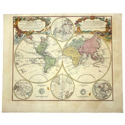
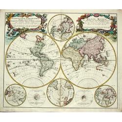
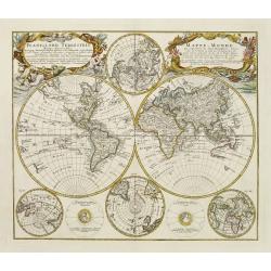
PLANIGLOBII TERRESTRIS. Mappa Universalis. - MAPPE - MONDE qui represente les deux Hemispheres savoir celui de l'Orient et celuit de l'Occident.
A world map in double hemisphere. In the centre two smaller hemispheres of the north and south pole are shown. Two interesting diagrams depict the earth as it would be se...
Place & Date: Nuremberg, 1746
Selling price: $850
Sold in 2019
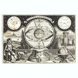
Systema Tychonicum.
Copper plate by Bernigeroth (1713-1767) after a work by Tyge Hofman 1746, with Tycho Brahe (1546-1601) astronomer from Denmark, in the lower left corner.
Place & Date: Leipzig, c. 1746
Selling price: $96
Sold in 2020
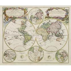
Planiglobii - Terrestris Mappa Universalis. . . Mappe Monde.
The eft cartouche title (in Latin) reads: Planiglobii Terrestris Mappa Universalis Utrumqs Hemisphaerium Orient et Occidentale ...; The right cartouche title (in French)r...
Place & Date: Nuremberg, 1746
Selling price: $700
Sold in 2021
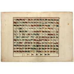
Les PAVILLONS des Mer du Monde Nouvellement Corriges.
A rare sheet with 192 maritime flags of nations and provinces with French names. With many interesting flags, like the one of Mallorca, Corsaires, Constantinople, Ragusa,...
Place & Date: Paris, 1746
Selling price: $120
Sold in 2020

NICOLAS DE FER GEOGRAPHE DE SA MAJETE CATHOLIQUE ET DE MONSEIGNEUR LE DAUPHIN. Mort en 1720. ago de 74 ans.
A finely engraved portrait of Nicolas De Fer, Geographer to the King, and one of the most important map makers of the early 18th Century. The portrait was engraved posthu...
Place & Date: Paris, 1746
Selling price: $200
Sold in 2020
Planiglobii Terestris ... / Mappe Monde...
Word map in double hemisphere. In center two smaller hemispheres of the north and south pole are shown. Two interesting diagrams depict the earth as it would be seen from...
Place & Date: Nuremberg, 1746
Selling price: $425
Sold in 2020
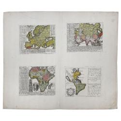
EUROPA... / AFRICA... / ASIA... / AMERICA, Poly-Glotta. . .
A rare map of the four continents identifying the prevalent languages of the world. Includes tables identifying the characters of the each continent. Africa map identifie...
Place & Date: Nuremberg, 1746
Selling price: $560
Sold in 2020
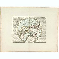
Carte du globe terrestre où les terres de l'hémisphère méridl sont supposées être vues à travers celles de l'hémisphère septentl.
Important single hemisphere world map prepared by Buache's with Sea of the West. Published in Buache's "Considérations géographiques et physiques", one of his...
Place & Date: Paris, 1746
Selling price: $200
Sold in 2021
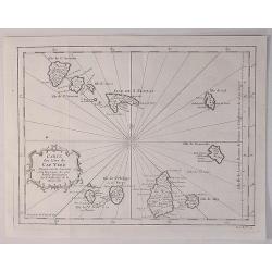
Carte des Isles du Cap Verd.
A decorative example of Bellin's map of the Cape Verde Islands, that features a decorative cartouche and compass rose.Jacques-Nicolas Bellin (1703-1772) was among the mos...
Place & Date: Paris, 1746
Selling price: $27
Sold in 2020
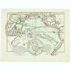
Carte physique de la Grande Mer ci-devant nommée Mer du Sud du Pacifique, qui traverse les parties le splus orientales de l'Asie . . .
General map of the Pacific ocean. Published in Buache's "Considérations géographiques et physiques", one of his most important and original cartographic works...
Place & Date: Paris, 1746
Selling price: $475
Sold in 2020
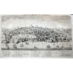
A Prospect of the City of Genoa.
A highly detailed birds-eye view of Genoa. Withy numerous buildings and landmarks of the surrounding area shown. The harbour is filled with sailing ships. A key below nam...
Place & Date: London, ca 1746
Selling price: $85
Sold in 2022

Nicolas De Fer Geographe de Sa Majesté Catholique et de Monseigneur Le Dauphin. Mort en 17120, agé de 74 ans.
An oval portrait of Nicolas De Fer, engraved by Pierre Dupin d'après Hyacinthe Rigaud. Dated 1746. Presented at the waist, the bust turned three-quarters towards the rig...
Place & Date: Paris, 1746
Selling price: $500
Sold in 2022
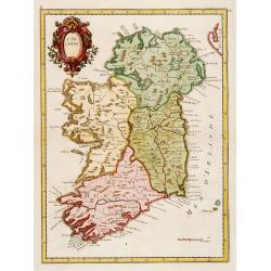
L'Irlande.
Fine map of Ireland.
Place & Date: Paris 1746
Selling price: $100
Sold
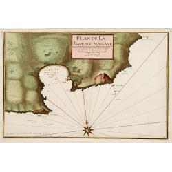
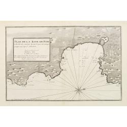
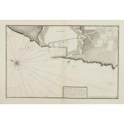
Plan de la Baye de Nagaye.
Prepared by Jacques Ayrouard and engraved by Louis Corne. Decorated with a large compass rose. From the rare chart book by Jacques Ayrouard: Recueil de plusieurs Ports .....
Place & Date: Marseille, 1732 - 1746
Selling price: $230
Sold
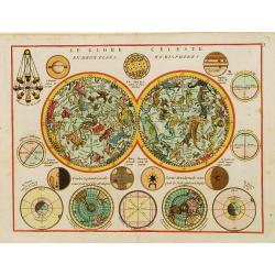
Le Globe Celeste en deux plans Hemispheres.
A very decorative double hemisphere celestial chart, centred on the North and South Poles, with 2 smaller terrestrial north and south pole projections, showing the inter-...
Place & Date: Paris 1746
Selling price: $320
Sold
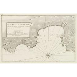
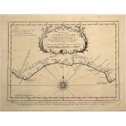
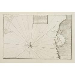
Plan de la Baye de Rose et des Côtes des environs de puis le port de Cadequié jusques au Cap St. Sebastien..
Coastal chart illustrating part of the Spanish Catalan country seacoast. It covers the area from south of Begur to today Cadaqués, close to the French border.From the ra...
Place & Date: Marseille, 1732 - 1746
Selling price: $175
Sold
![[Untitled Front views of the coastal relief of Provence]](/uploads/cache/23302-250x250.jpg)
[Untitled Front views of the coastal relief of Provence]
Copper engraving presenting separate front views of the coastal relief of Provence divided in stripes.It covers the area which extends from Cap Sicié as far as Monaco, i...
Place & Date: Marseille, 1732 - 1746
Selling price: $140
Sold
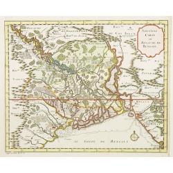
Nouvelle carte du Royaume de Bengale.
Rare map of Bangladesh with the Ganges delta, including Calcutta. Giving great detail with trade routes, European trade settlements, etc. Prepared by Joh. Van Leenen who ...
Place & Date: Paris 1746
Selling price: $150
Sold in 2020

Carte des Isles Canaries..
A good engraved map of the Canary islands, with rococo title cartouche upper part. From l'Histoire générale des voyages .
Place & Date: Paris 1746
Selling price: $50
Sold
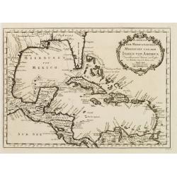
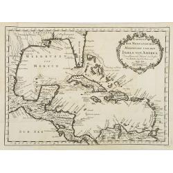
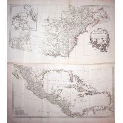
Karte von dem Mexicanischen Meerbusen und dem Inseln von America..
Fine map of the Caribbean, including Florida.Jacques Nicolas Bellin (1703-1772) was one of the most important and proficient French cartographers of the mid-eighteenth ce...
Place & Date: Leipzig, Arkstee & Merkus, 1746
Selling price: $210
Sold
Planiglobbi Terrestris Mappa Universalis Utrumq Hemisphaerium Orient et Occidentale repraesentans / Mappe-Monde qui represente les Deux Hemispheres.
Homann Heirs (of Johann Baptist and Johann Christof) published: Grosser Atlas, 1731, 1737. Geogr. Maior, 1759, Atlas Homannianus, 1762.An attractive world map in 2 hemisp...
Place & Date: Nürnberg, 1746
Selling price: $1500
Sold in 2011
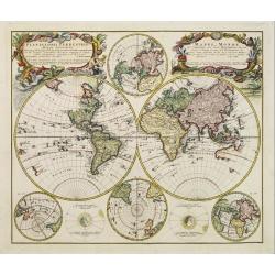
Planiglobii Terrestris Mappa Universalis.. - Mappe-Monde qui represente les deux Hemispheres..
Word map in double hemisphere. In centre two smaller hemispheres of the north and south pole are shown. Two interesting diagrams depict the earth as it would be seen from...
Place & Date: Nuremberg 1746
Selling price: $875
Sold
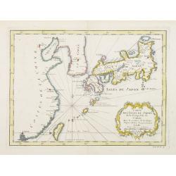
Carte des Isles du Japon et la Presqu'Isle de Coree..
A fine map of the islands of Japan embellished with fine baroque decorations.Bellin influenced other cartographers with his erroneous portrayals of Japan. Included in Ant...
Place & Date: Paris 1746
Selling price: $100
Sold
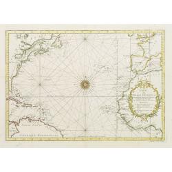
Carte De L'Ocean Occidental Dreessée pour Servir a l'Histoire Generale des voyages..
Attractive chart of the Atlantic, north of the equator, delineated with rhumb lines and a large 32-point compass rose.A good portion of each of the continents is shown wi...
Place & Date: Paris 1746
Selling price: $100
Sold
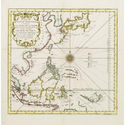
Suite De L'Ocean Oriental.. Chine Les Isles Du Japon..
Fine map of South East Asia, New Guinee, coast of China, Korea and Japan. Several coastal towns noted, but little depicted in the interior.Japan is shown in Bellin's dist...
Place & Date: Paris 1746
Selling price: $140
Sold
Americae Mappa Generalis
An updated map of the western hemisphere by the Homann Heirs. The map shows the continent on the eve of the conflicts that would soon erupt and change the political face ...
Place & Date: Nuremberg, ca. 1746
Selling price: $850
Sold
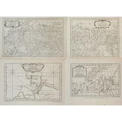
![[5 charts of Spanish coasts and harbours.] Plan du Port et Rade ... Jacques Ayrouard](/uploads/cache/23140-250x250.jpg)
[5 charts of Spanish coasts and harbours.] Plan du Port et Rade ... Jacques Ayrouard
A set of 5 coastal charts from the rare chart book by Jacques Ayrouard: Recueil de plusieurs Ports ... de la Mer Mediterranie.Plan du Port et Rade de Palamos en Catalogne...
Place & Date: 1732-1746
Selling price: $750
Sold
Planiglobii Terrestris Mappa Universalis.. - Mappe-Monde qui represente les deux Hemispheres..
Word map in double hemisphere. In center two smaller hemispheres of the north and south pole are shown. Two interesting diagrams depict the earth as it would be seen from...
Place & Date: Nuremberg 1746
Selling price: $800
Sold
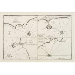
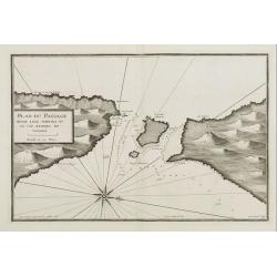
Plan du Passage du Fort Brescon - Plan de la Rade de..
Four charts on one plate : Plan du Passage du Fort Brescon.. - Plan de la Rade de Peniscola en Valence.- Plan de la Rade de Carpi en Valence.- Plan de la Rade de Benidorm...
Place & Date: 1732-1746
Selling price: $100
Sold
Plan de la Baye de Rose et des Côtes des environs de puis le port de Cadequié jusques au Cap St. Sebastien..
Uncommon chart illustrating part of the Spanish Catalan country seacoast. It covers the area from south of Begur to today Cadaqués, close to the French border.From the r...
Place & Date: Marseille 1732 -1746
Selling price: $425
Sold
![[Untitled Front views of the coastal relief of the Gulf of Valencia as far as Catalonia]](/uploads/cache/23947-250x250.jpg)
[Untitled Front views of the coastal relief of the Gulf of Valencia as far as Catalonia]
Copper engraving presenting separate front views of the southeastern coastal relief of Spain divided in stripes.Covering the area which extends from the Gulf of Valencia ...
Place & Date: Marseille 1732 - 1746
Selling price: $40
Sold
![[Untitled] Front views of the coastal relief of Sardinia.](/uploads/cache/24831-250x250.jpg)
[Untitled] Front views of the coastal relief of Sardinia.
Copper engraving presenting separate front views of the coastal relief of Sardinia and the Ponziane Islands, divided in stripes.From the rare chart book by Jacques Ayroua...
Place & Date: Marseille, 1732 - 1746
Selling price: $80
Sold in 2009
![[Untitled] Front views of the Riviera.](/uploads/cache/24832-250x250.jpg)
[Untitled] Front views of the Riviera.
Copper engraving presenting separate front views of the Italian Riviera.It covers the whole Gulf of Genoa and Monaco.From the rare chart book by Jacques Ayrouard: Recueil...
Place & Date: Marseille, 1732 - 1746
Selling price: $85
Sold
![[Untitled] Front views of the coastal relief of Corsica and Tuscany.](/uploads/cache/24834-250x250.jpg)
[Untitled] Front views of the coastal relief of Corsica and Tuscany.
Copper engraving presenting separate front views of the coastal relief of northern Corsica and the facing Tuscan shores, divided in stripes.From the rare chart book by Ja...
Place & Date: Marseille, 1732 - 1746
Selling price: $55
Sold
![[Untitled] Front views of the Tyrrhenian coastal relief of Italy.](/uploads/cache/24835-250x250.jpg)
[Untitled] Front views of the Tyrrhenian coastal relief of Italy.
Copper engraving presenting separate front views of the coastal relief of Italy between Tuscany and Campania with its Tyrrhenian islands, divided in stripes.From the rare...
Place & Date: Marseille, 1732 - 1746
Selling price: $50
Sold in 2009
![[Untitled] Front views of the Italian coastal relief.](/uploads/cache/24836-250x250.jpg)
[Untitled] Front views of the Italian coastal relief.
Copper engraving presenting separate front views of the Tyrrhenian as well as Ionian coastal relief of Italy, divided in stripes.From the rare chart book by Jacques Ayrou...
Place & Date: Marseille, 1732 - 1746
Selling price: $60
Sold in 2009
![[Untitled] Front views of the Spanish coastal relief.](/uploads/cache/24838-250x250.jpg)
[Untitled] Front views of the Spanish coastal relief.
Separate front views mainly depicting the coastal relief of Catalonia, divided in stripes.From the rare book by Jacques Ayrouard: Recueil de plusieurs Ports .. de la Mer...
Place & Date: Marseille 1732 - 1746
Selling price: $155
Sold
![[Untitled] Front views of the coastal relief of the French Riviera.](/uploads/cache/24840-250x250.jpg)
[Untitled] Front views of the coastal relief of the French Riviera.
Separate front views depicting the coastal relief of French Riviera, divided in stripes.It covers the littoral zone between Monaco as far as the Iles Hyères.From the rar...
Place & Date: Marseille, 1732 - 1746
Selling price: $55
Sold
Plan du Passage Entre L isle Azinara et le Cap Azinara de Sardaigne.
Copper engraving depicting the northwestern tip of Sardinia and the southern tip of the Asinara Island.Oriented with West on top. Decorated with a large compass rose.From...
Place & Date: Marseille, 1732 - 1746
Selling price: $135
Sold
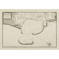
Plan du Port et Rade de Livourne..
Copper engraving showing the harbor and roadstead of Livorno with the adjacent seashores. Decorated with a large compass rose.From the rare chart book by Jacques Ayrouard...
Place & Date: Marseille, 1732 - 1746
Selling price: $225
Sold in 2009
Plan du Port et Rade de Livourne..
Copper engraving centered on the harbour and roadstead of Livorno. Decorated with a large compass rose.From the rare chart book by Jacques Ayrouard: Recueil de plusieurs ...
Place & Date: Marseille, 1732 - 1746
Selling price: $150
Sold in 2015
Plan du Port de Civita-Vechia. . .
Large plan of the harbour in Civitavecchia. Decorated with a large compass rose.From the rare chart book by Jacques Ayrouard: Recueil de plusieurs Ports .. de la Mer Méd...
Place & Date: Marseille, 1732 - 1746
Selling price: $150
Sold in 2015
![[Untitled] Front views of the Italian coastal relief.](/uploads/cache/24848-250x250.jpg)
[Untitled] Front views of the Italian coastal relief.
Copper engraving presenting separate front views of the Tyrrhenian as well as Ionian coastal relief of Italy, divided in stripes.From the rare chart book by Jacques Ayrou...
Place & Date: Marseille 1732 - 1746
Selling price: $30
Sold
L'Amerique Septentrionale.
Interesting map of North America. In north eastern part of North America some interesting lakes and rivers are drawn, with a note: Terres vues par Tchirikow en 1741 . Tch...
Place & Date: Paris, 1746
Selling price: $150
Sold in 2017
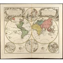
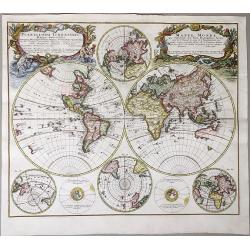
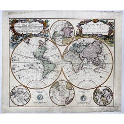
Planiglobii Terrestris Mappa Universalis Utrumq Hemisphaerium Orient et Occidentale repraesentans, Erx IV mappis generalibus Hasianis composita et adjectis ceteris hemisphaeriis designata a G.M. Lowizio. Excudentibus Homann Heredibus
Hand colored double hemisphere world map by J. M. Hase published by Homann Heirs showing also two circular charts of the North Pole and the South Pole and two small circu...
Place & Date: Nuremberg, 1746
Selling price: $1200
Sold in 2009
Planiglobii Terrestris Mappa Universalis.. - Mappe-Monde qui represente les deux Hemispheres..
Word map in double hemisphere. In centre two smaller hemispheres of the north and south pole are shown. Two interesting diagrams depict the earth as it would be seen from...
Place & Date: Nuremberg, 1746
Selling price: $2200
Sold
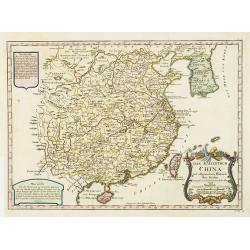
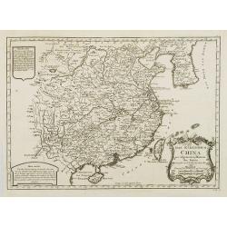
Das Kaiserthum China zur allgemeinen Historie der Reisen - entworfen von N. Bellin Ing. de la Mar. 1748.
Attractive and detailed map of China and Korea. The Sea of Japan is labeled "Das meer von Korea". The composition is nicely balanced with three decorative carto...
Place & Date: Leipzig, Arkstee & Merkus, 1746
Selling price: $85
Sold in 2008
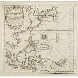
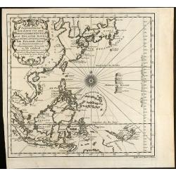
Fortsetzung der Karte von dem Morgenlaendischen Ocean die Eylande Sonda die Küsten von Tunquin und China die Eylande Japon.
Interesting and detailed map of Southeast Asia by Nicolas Bellin. Showing the Philippines, Indonesia, Japan, the east coast of China and parts of Papua New Guinea. With a...
Place & Date: Leipzig, Arkstee & Merkus, 1746
Selling price: $200
Sold in 2009
Karte von dem Mexicanischen Meerbusen und dem Inseln von America..
Fine map of the Caribbean, including Florida. From the German edition of Prevost's "L'Histoire Générale des Voyages" by J. J. Schwabe in Leipzig.Jacques Nicol...
Place & Date: Leipzig, Arkstee & Merkus, 1746
Selling price: $200
Sold in 2008
Karte von Luisiana, dem Laufe des Mississipi und den Benachbarten Laendern.
A rare German text edition of de l\'Isle\'s map of North America, focusing on the Mississippi and covering all the known United States, from the Rio del Norte (extending ...
Place & Date: Leipzig, Arkstee & Merkus, 1746
Selling price: $350
Sold in 2008
![Ins Kleine Gebrachte Karte von den Sud-Laendern zur Histoire der Reisen. [Australia]](/uploads/cache/26065-250x250.jpg)
Ins Kleine Gebrachte Karte von den Sud-Laendern zur Histoire der Reisen. [Australia]
A uncommon map of Australia, one of the few 18th century maps concentrating on the Australian continent. With a reference noting a fictitious visit to south-west New Holl...
Place & Date: Leipzig, Arkstee & Merkus, 1746
Selling price: $710
Sold in 2008
Lot of four maps showing Siberia and parts of Northern Russia.
Carte de la Siberie . ., 1754. Detailed overview of Siberia, showing cities, towns, mountainous and forested areas, and the region's numerous rivers. Route tracks of the...
Place & Date: Paris, ca.1746
Selling price: $80
Sold in 2008
Fortsetzung der Karte von dem Morgenlaendischen Ocean die Eylande Sonda die Küsten von Tunquin und China die Eylande Japon
Interesting and detailed sea chart of Southeast Asia by Nicolas Bellin. Showing the Philippines, Indonesia, Japan, the east coast of China and parts of Papua New Guinea. ...
Place & Date: Leipzig, 1746
Selling price: $160
Sold in 2010
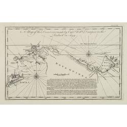
A Map of the Discoveries made by Capt.n Will.m Dampier in the Roebuck in 1699.
Uncommon and important map showing the New Britain Island in the Bismarck Sea. The map includes also the Indonesian island of Timor and surrounding islands, Irian Jaya an...
Place & Date: London, 1746
Selling price: $200
Sold in 2009
Karte von Luisiana, dem Laufe des Mississipi und den Benachbarten Laendern.
A rare German text edition of de l'Isle's map of North America, focusing on the Mississippi and covering all the known United States, from the Rio del Norte (extending no...
Place & Date: Leipzig, Arkstee & Merkus, 1746
Selling price: $960
Sold in 2015
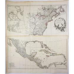
Amérique Septentrionale.
2 x 2 joined sheets.
Place & Date: Paris, 1746
Selling price: $750
Sold in 2009
![[Untitled] Front views of the Spanish coastal relief.](/uploads/cache/28217-250x250.jpg)
[Untitled] Front views of the Spanish coastal relief.
Separate front views depicting great part of the Mediterranean coast of Spain, including Brescon, divided in stripes.It covers the littoral zone between Peñíscola and G...
Place & Date: Marseille, 1732 - 1746
Selling price: $120
Sold in 2010
Das Kaiserthum China zur allgemeinen Historie der Reisen - entworfen von N. Bellin Ing. de la Mar. 1748.
Attractive and detailed map of China and Korea. The Sea of Japan is labeled "Das meer von Korea". The composition is nicely balanced with three decorative carto...
Place & Date: Leipzig, Arkstee & Merkus, 1746
Selling price: $300
Sold