Browse Listings
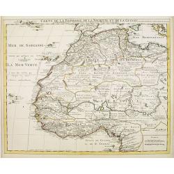
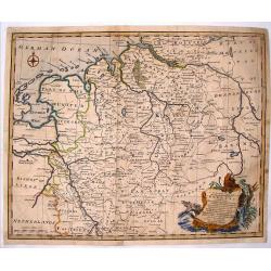
Carte de la Barbarie de la Nigritie et de la Guinée..
Richly engraved map of North and West Africa, based upon the earlier maps of De L'Isle. Richly annotated throughout and with excellent regional detail. It includes the Ca...
Date: Amsterdam, c. 1745
Selling price: ????
Please login to see price!
Sold in 2022
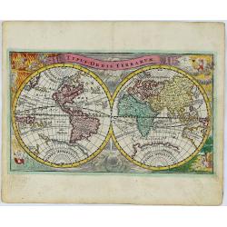
Typus Orbis Terrarum.
A decorative and rare World map published by Adam Friedrich Zurner in Nuremberg. California is shown as an island with a narrowing, irregular northern coast, substantial ...
Date: Nürnberg, 1745
Selling price: ????
Please login to see price!
Sold in 2018

Vue du Château de Marli. Prise du bas du grand parterre. . .
A magnificent view of a stunning Château de Marli by the celebrated landscape engraver Jacques Rigaud (1681-1754). At the Château of Marly, Louis XIV of France escaped ...
Date: Paris, c. 1745
Selling price: ????
Please login to see price!
Sold in 2009
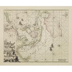
Orientaliora Indiarum Orientalium. . .
This is a corrected version of De Wit. Tasmania is inserted, and New Britain with Dampier's route 1700, now changes the shape of New Guinea. The chart has also been corre...
Date: Amsterdam, 1745
Selling price: ????
Please login to see price!
Sold in 2008
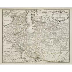
Carte de Perse dressée pour l'usage du Roy. . .
Detailed map of Persia embellished with a title cartouche featuring the French crown and coat of arms. Prepared by one of the major key figures in the development of Fren...
Date: Paris, 1745
Selling price: ????
Please login to see price!
Sold
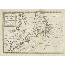
A new map of New Foundland, New Scotland. The Isles of Breton, Antocoste, St. Johns. . .
Fine map shows Newfoundland with the neighboring 'Cap Breton' and 'New Arcadia'. Hermann Moll's map provided a fair amount of information on place names, mostly along the...
Date: London, 1745
Selling price: ????
Please login to see price!
Sold in 2008
Charte derer von der Russischkeyser Armee im Jahr 1736 zwischen und an dem Dnieper und Donn wieder die Turcken und Tartarn siegreich unternommenen Kriegs-Operationen.
Scarce map illustrating the territories between the rivers Dnieper and Donn felt under Russian domination in 1736. The map is sometimes bound in the Atlas Russicus, print...
Date: Srt. Petersbourg, 1745
Selling price: ????
Please login to see price!
Sold in 2008
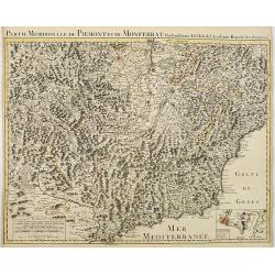
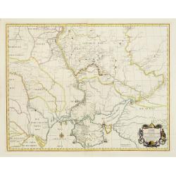
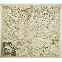
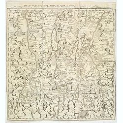
Partie Meridionale du Piemont et du Monferrat . . . plusieurs Cartes..
Large, detailed map of Valle d'Aosta and most part of Piedmont. Includes illustrated topography with notations about towns, roads, passes, mountains, etc. Relief shown pi...
Date: Amsterdam, c. 1745
Selling price: ????
Please login to see price!
Sold
Carte de Perse dressée pour l'usage du Roy. . .
Detailed map of Persia embellished with a title cartouche featuring the French crown and coat of arms. Prepared by one of the major key figures in the development of Fren...
Date: Paris, 1745
Selling price: ????
Please login to see price!
Sold in 2009
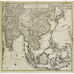
Carte des Indes et de la Chine Dressée . . .
Large and attractive map of South East Asia, India and China.The map is of interest for the use of East Sea, the sea between Korea and Japan, here called "Mer Orient...
Date: Amsterdam, c. 1745
Selling price: ????
Please login to see price!
Sold
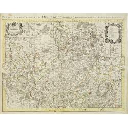
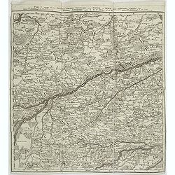
Partie Septentrionale du Duche de Bourgogne . . .
Large, detailed map of northern Burgundy, covering the region from Bar-sur-Seine in the North to Dijon and Auxonne in the South East. Shows many villages, towns, roads an...
Date: Amsterdam, ca. 1745
Selling price: ????
Please login to see price!
Sold
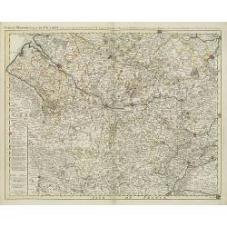
Partie meridionale de Picardie dressee sur les operations geometriques de Mrs. Lesperson & de Rousseville et sur plusieurs autres memoires Par Guillaume Del'isle . . .
Engraved map of the Picardie region in northern France. Urban areas in color. Relief is shown pictorially. Shows forests, Roman roads, churches, abbeys by religious order...
Date: Amsterdam, 1745
Selling price: ????
Please login to see price!
Sold in 2009
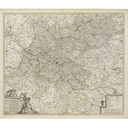
Gouvernement Général de L'Isle de France . . .
A fine engraved map centered on Paris metropolitan area and its vicinities in the Isle de France region. Decorative title and scale cartouches.The map is from a Dutch edi...
Date: Paris, ca. 1745
Selling price: ????
Please login to see price!
Sold in 2012
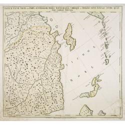
Ostium Fluvii Amur cum parte australiori terrae Kamtschatkae variisque in Oceano sitis Insulis inter quas pars eminet Japoniae. No.19
Detailed map of part of Siberia in Russia, including in the lower right part the Northern tip of Hokkaido and in the upper right corner the southern tip of Kamchatka. The...
Date: Petersburg, 1745
Selling price: ????
Please login to see price!
Sold in 2009
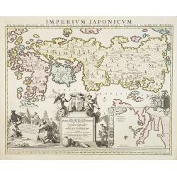
Imperium Japonicum Per Regiones Digestum Sex et Sexaginta Atque Ipsorum Japonensium Mappis Descriptum Ab Hadriano Relando.
Prepared by H.Reland (1676-1718) a professor active in Utrecht and specialized in Asian languages, geography and religions. His first map was a map of Japan copied after ...
Date: Amsterdam, 1745
Selling price: ????
Please login to see price!
Sold
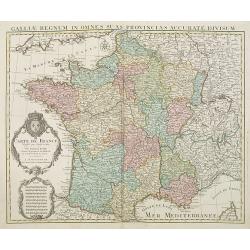
Carte De France Dressée pour l'usage du Roy. . .
Beautifully engraved, detailed general map of France, illustrating towns, roads, rivers, forests, etc. Embellished by two decorative cartouches: a title cartouche surmoun...
Date: Amsterdam, c. 1745
Selling price: ????
Please login to see price!
Sold
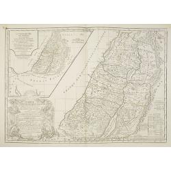
La Monarchie des Hebreux sous Salamon, ou le royaume D'Israel. . . / Carte de la terre des Hebreux ou Israelites. . .
Two maps of the Holy Land on one sheet representing the Monarchy of the Hebrews under Solomon divided into 12 governments. The Kingdom of Solomon includes not only Palest...
Date: Paris, 1745
Selling price: ????
Please login to see price!
Sold in 2011
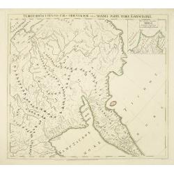
Territorii Iacutensis pars orientalior cum maxima parte terrae Kamtschatkae.
Detailed map of part of Siberia, including Kamtschatka. In the upper right corner an inset map 115x130mm of Siberia. The map was prepared by Joseph Nicolas De L'Isle and ...
Date: Petersburg, 1745
Selling price: ????
Please login to see price!
Sold in 2010
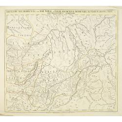
Irkutensis vice praefectura cum Mari Baikal, et fonte Fluvü Lenae, partibusque Fluviorum Argun et Amur. N. 17.
Detailed map of part of Siberia, including Baikal lake and Irkuck. The map was prepared by Joseph Nicolas De L'Isle and was included in "Atlas Russicus". The Ru...
Date: Petersburg, 1745
Selling price: ????
Please login to see price!
Sold in 2010
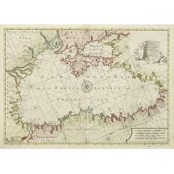
Pontus Euxinus of niewe en Naaukeurige paskaart van de Zwarte Zee. . .
Beautifully engraved map of the Black Sea prepared by Willem Witsen. This is the rare Ottens edition, where the address of Renard is replaced by the address of R. and J. ...
Date: Amsterdam, 1745
Selling price: ????
Please login to see price!
Sold in 2010
Tabula geographica exhibens regnum Sclavoniae. . .
Detailed copper-engraved map of Slavonia, the region in eastern Croatia. Belgrade to the east with the Danube, with the Sava a right side tributary of the Danube river.Ma...
Date: Nuremberg, 1745
Selling price: ????
Please login to see price!
Sold in 2011
![The History of the Court of the King of China [with] An Account of the Empire of China. . .](/uploads/cache/99680-250x250.jpg)
The History of the Court of the King of China [with] An Account of the Empire of China. . .
Complete account extracted from a contemporary collection of voyages in French and Spanish and translated into English. Includes a map of China by Herman Moll.
Date: London, 1745
Selling price: ????
Please login to see price!
Sold in 2012
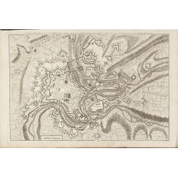
Nouveau Plan de Luxembourg
A rare plan of Luxembourg by Le Rouge. Showing the fortified city with the adjacent streets, title on top.
Date: Paris, 1745
Selling price: ????
Please login to see price!
Sold in 2010
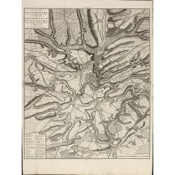
Plan de Luxembourg de ses Nouvelles Fortifications et de ses Environs
A large, scarce of Luxembourg by Covens & Mortier. Based on an earlier Jaillot map. Including a key showing 41 place names. Printed on heavy paper.
Date: Amsterdam, 1745
Selling price: ????
Please login to see price!
Sold in 2010
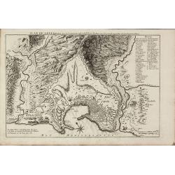
Plan de Genes
A rare plan of Genoa by Le Rouge. Showing the fortified city with the adjacent streets, title on top, key on the right. Decorated with a compass rose.
Date: Paris, 1745
Selling price: ????
Please login to see price!
Sold in 2011
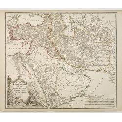
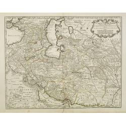
Etats du Grand-Seigneur en Asie, Empire de Perse, Pays des Usbecs, Arabie et Egypte.
Detailed map of the region bounded by the Black Sea, Georgia, the Caspian, Uzbekistan, The Indian Ocean, Saudi Arabia ("Arabie Heureuse"), Egypt, and the Red Se...
Date: Paris, c.1745
Selling price: ????
Please login to see price!
Sold in 2010
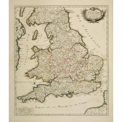
Le royaume d'Angleterre divisé en Comte et Baronies. . .
Fine map of England and Wales. As well as country details, including the main post roads. Le Rouge was active from 1740- till 1780 as a publisher, and was appointed engin...
Date: Paris, 1745
Selling price: ????
Please login to see price!
Sold in 2011
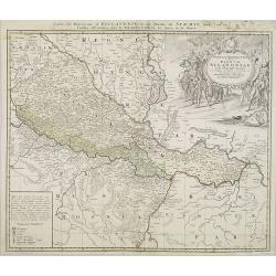
Carte des Comtéz de HAINAUT de NAMUR et de CAMBRESIS.
Map of the region of Mons, Maubeuge, Valencienes in the North of France and Namen and Huy in Belgium.Philippe Buache de la Neuville was born in Neuville-en-Pont (France) ...
Date: Paris, 1745
Selling price: ????
Please login to see price!
Sold in 2020
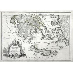
Graeciae Antiquae Tabula Nova . . .
Finely detailed map of Greece, Crete and the southeastern coast of Asia Minor based on a 1707 map by de L'Isle, and later republished by Buache in 1745. Cities, villages,...
Date: Paris, 1745
Selling price: ????
Please login to see price!
Sold in 2010
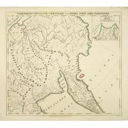
Territorii Iacutensis pars orientalior cum maxima parte terrae Kamtschatkae.
Detailed map of part of Siberia, including Kamtschatka. In the upper right corner an inset map 115x130mm of Siberia. The map was prepared by Joseph Nicolas De L’Isle an...
Date: Petersburg, 1745
Selling price: ????
Please login to see price!
Sold in 2010
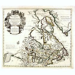
![Cartes Des Courones Du Nord Qui Comprend les Royaumes de Danemark, Suede & Nowege, &c.. [together with] Seconde Carte des Courones du Nord..](/uploads/cache/29997-250x250.jpg)
Cartes Des Courones Du Nord Qui Comprend les Royaumes de Danemark, Suede & Nowege, &c.. [together with] Seconde Carte des Courones du Nord..
Large, highly detailed two sheet map of Scandinavia. Beautifully engraved with a decorative title cartouche and 2 compass roses.Shows illustrated topography with roads, r...
Date: Amsterdam c. 1745
Selling price: ????
Please login to see price!
Sold in 2010
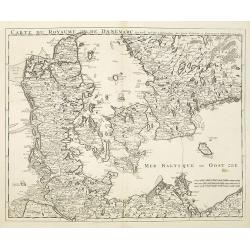
Carte Du Royaume de Danemarc.
Beautifully engraved, highly decorative map showing all of Denmark and southern Sweden, extending north to Warberg.The map is from a Dutch edition of De L'Isle's work ent...
Date: Amsterdam, c. 1745
Selling price: ????
Please login to see price!
Sold in 2011
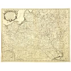
Le Royaume de Pologne, Le Grand Duché de Lithuanie suivant les nouvelles Observations.
Rare map of Poland. Le Rouge, who was lieutenant in the regiment of Saxe before establishing himself as publisher, compiler and editor of maps at the rue des Grands Augus...
Date: Paris, 1745
Selling price: ????
Please login to see price!
Sold in 2010
Moscoviae gubernium cum Adiacentibus regionibus. . .
Detailed map of center of Russia. Showing the cities Moscow, Twer, Jaroslaw. This map was included in the important Atlas Russicus, the first atlas of Russia to be publis...
Date: St Petersburg, 1745
Selling price: ????
Please login to see price!
Sold in 2011
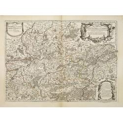
Pars V. ostendit partem Ducatus Bavariae inferioris. . .
Map of southern part of Germany, showing the river Isar from Freising until Landshut. Very detailed map. Prepared by Wilhelm C. Buna and published by Broenner in Frankfur...
Date: Frankfurt, M. Broenner, 1745
Selling price: ????
Please login to see price!
Sold in 2015
Le Neptune Oriental ou Routier Général des Côtes des Indes Orientales et de la Chine...
First edition. - D'Après de Mannevillette (1707-1780) was a famous French sailor and hydrographer. During a voyage to China in 1728 he succeeded in correcting the latitu...
Date: Paris, Jean-François Robustel, 1745
Selling price: ????
Please login to see price!
Sold in 2011
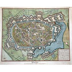
MONS the Capital City of Hainault in ye Low Countries, taken by ye French in 1691...
Superb bird's-eye plan of the city and fortifications of Mons. Beautifully illustrating the city with its buildings and churches in great detail. Also with two windmills,...
Date: London, ca. 1745
Selling price: ????
Please login to see price!
Sold in 2011
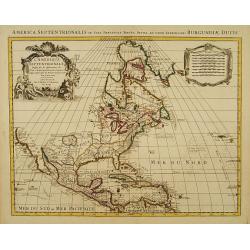
Carte d' Amerique Dressee pour l'Usage Du Roy. . .
Detailed copper-engraved map of Northern and Central America. Shows North America with colonial divisions and a wide open Northwest. The English settlements are confined ...
Date: Amsterdam c. 1745
Selling price: ????
Please login to see price!
Sold in 2018
Carte du Canada ou de la Nouvelle France et des Decouvertes qui y ont ete faites..
Highly detailed copper-engraved map of Canada and the Great Lakes providing the most accurate rendering of the Great Lakes of the time, with the lakes fully enclosed and ...
Date: Amsterdam c. 1745
Selling price: ????
Please login to see price!
Sold in 2019
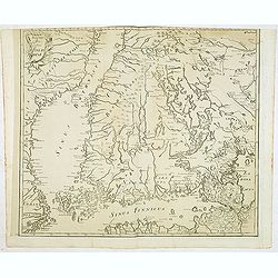
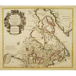
(Finland)
One of the earliest detailed maps of Finland, prepared by Joseph Nicolas De L’Isle and included in a later edition of the "Atlas Russicus". The Russian Academ...
Date: Petersburg, 1745
Selling price: ????
Please login to see price!
Sold in 2012
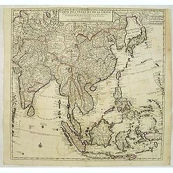
Carte des Indes et de la Chine Dressée . . .
Large and attractive map of South East Asia, India and China.The map is of interest for the use of East Sea, the sea between Korea and Japan, here called "Mer Orient...
Date: Amsterdam, c. 1745
Selling price: ????
Please login to see price!
Sold in 2012
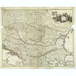
Théatre de la Guerre en Hongarie, Transilvanie &c
Large, four sheet detailed map of Hungary.
Date: Amsterdam c. 1745
Selling price: ????
Please login to see price!
Sold in 2012
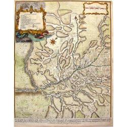
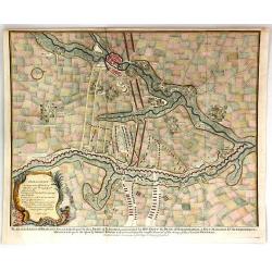
Plan of the Incampment of the Allies at Prats Del Rey.
This large plan of the Encampment at Prat del Rey, Spain, a town approximately 50 Kilometres inland from Barcelona, not far from the modern town of Igualada, in the provi...
Date: London, 1745
Selling price: ????
Please login to see price!
Sold in 2013
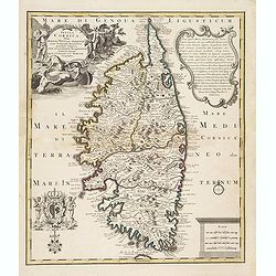
Insula Corsica, Olim Rehni Titulo Insignis . . . .
Large detailed map of Corsica. Splendid cartouche of picturesque scene of people at work engaged in their daily activities admits dogs and local fauna on the upper left c...
Date: Amsterdam, ca 1745
Selling price: ????
Please login to see price!
Sold
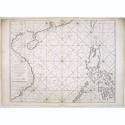
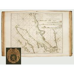
Carte plate qui comprend les Costes de Tsiompa, de la Cochinchine, le golfe de Tunquin, une partie des costes de la Chine avec une partie de l'Archipel des Isles Philippines. . .
Important French of the China Sea with the coast of Southern China, including Hong Kong and the southern tip of Taiwan. Great detail on the Philippines.Engraved by Guill...
Date: Paris, Jean-François Robustel, 1745
Selling price: ????
Please login to see price!
Sold
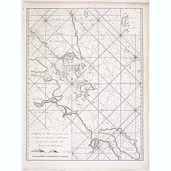
Carte des mers comprises entre le détroit de Banca et P°. Timon avec la partie orientale du détroit de Malacca.
Important French chart of the tip of Malaysia with Singapore.Latitude and longitude scales, compass rose and system of rhumb lines, soundings near coast and in bay areas....
Date: Paris, Jean-François Robustel, 1745
Selling price: ????
Please login to see price!
Sold in 2014
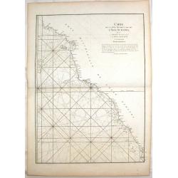
Carte de la Cote Occidentale de L'isle Sumatra.
Coastal Map of West Sumatra, an island in Western Indonesia. It is from Le Neptune Oriental. Jean-Baptiste d'Après de Mannevillette (1707-1780) was a French sailor, nav...
Date: Paris, 1745
Selling price: ????
Please login to see price!
Sold in 2018
Pars VII. Describit partem regim : Monach / Intra Lycum et Isaram. . .
Map of the south of Germany with Munich in the upper right corner and Walchen See in the bottom. The River Lech to the left.
Date: Frankfurt, 1745
Selling price: ????
Please login to see price!
Sold in 2014
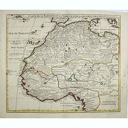
Carte de La Barbarie de La Nigritie et de la Guinée.
Richly engraved map of North and West Africa, based upon the earlier maps of De L'Isle. Richly annotated throughout and with excellent regional detail. It includes the Ca...
Date: Amsterdam, ca. 1745
Selling price: ????
Please login to see price!
Sold in 2014
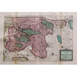
Kaart van Noord-Holland...
Interesting map of the northern part of the Netherlands. Oriented to the west. It extends from Amsterdam northward as far as Texel and southward as far as Enkhuizen. With...
Date: Amsterdam, c1745
Selling price: ????
Please login to see price!
Sold in 2014
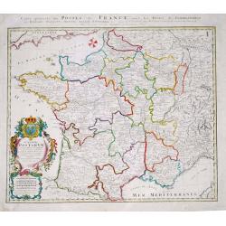
Gallia Postarum geografice designata.
Homann Heirs (of Johann Baptist and Johann Christof) published: Grosser Atlas, 1731, 1737. Geogr. Maior, 1759, Atlas Homannianus, 1762.Alexis Jaillot's map showing the po...
Date: Nurnberg, 1745
Selling price: ????
Please login to see price!
Sold in 2019
A Correct Map of the North West Part of Germany.
A map of the north western portion of Germany. The cartographer was Emmanuel Bowen and the map is from Mr. Tindal's "Continuation of Rapin's History".Features a...
Date: London, 1745
Selling price: ????
Please login to see price!
Sold in 2016
De Groote Nederlandse Stedenwyzer, vertoonende met een opslag des Oogs, de Afgelegentheden tussen 108 Steden, van de XVII. Nederlandse Provintien. . .
In upper right corner inset map of the Low Countries. The page is filled with a scale which shows distances between cities and provinces.
Date: Amsterdam, 1745
Selling price: ????
Please login to see price!
Sold in 2017
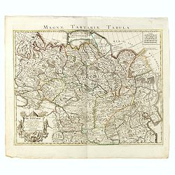
Carte de Tartarie Dressée sur les Relations de plusieurs Voyageurs. . .
Detailed copper-engraved map representing Tartary, with decorative title cartouche. Shows today's territory of Russia including Siberia, North China, Korea. With sub titl...
Date: Amsterdam, c. 1745
Selling price: ????
Please login to see price!
Sold
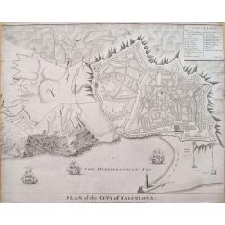
Plan of the City of Barcelona.
Boldly engraved plan of Barcelona. Shows the detailed walled city, surrounded with roads and fields. Numerous fortifications are located, and there is a lettered key (A-X...
Date: London, ca. 1745
Selling price: ????
Please login to see price!
Sold in 2019
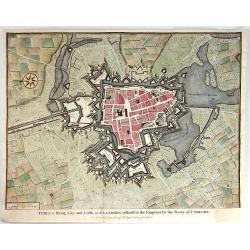
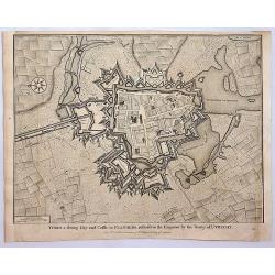
Ypres a Strong City and Castle in Flanders, Restored to the Emperor by the Treaty of Utrecht.
A fine and detailed view of the city of Ypres in Flanders as was included in Mr. Tindal's 'Continuation of Mr. Rapin's History of England'.
Date: London, 1745
Selling price: ????
Please login to see price!
Sold in 2016
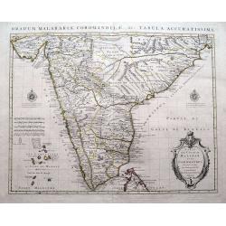
Carte des Côtes de Malabar et de Coromandel...
A fantastic map of southern India. Indicates the names of the European countries in power in several cities, for example "Cochin aux Hollandois"; "Pondiche...
Date: Amsterdam, c1745
Selling price: ????
Please login to see price!
Sold in 2016
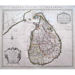
Carte de L'Isle de Ceylan Dressée sur les Observations...
A scarce large scale map of Sri Lanka (Ceylon). Highly detailed with many place names, rivers, hills, roads, and depth soundings shown.Embellished with two decorative car...
Date: Amsterdam, c 1745
Selling price: ????
Please login to see price!
Sold in 2016
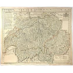
Carte de Suisse.
A large, clear and detailed map of Switzerland and northern Italy, outlining the cantons, with their coats of arms at upper border alongside title. ‘Avertissement’ at...
Date: Paris, 1745
Selling price: ????
Please login to see price!
Sold in 2016
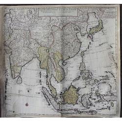
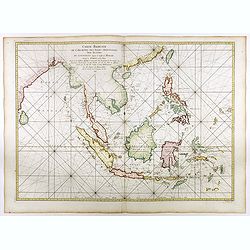
Carte des Indes et de la Chine Dressée. . .
A large, important, and very decorative map of South East Asia, India and China.The map is particularly interesting due to the appearance of the sea between Korea and Jap...
Date: Amsterdam, ca. 1745
Selling price: ????
Please login to see price!
Sold in 2020
Plan of the Lines of Brabant Forced July 18, 1704 by the Army of the Allies
A detailed military map, engraved from 'Mr. Tindal's Continuation of Mr. Rapin's 'History of Engand'. With maps by Richard William Seale and John Basire, published by Rap...
Date: London, ca. 1745
Selling price: ????
Please login to see price!
Sold in 2019
Carte du Canada ou de la Nouvelle France et des Decouvertes qui y ont ete faites..
Highly detailed copper-engraved map of Canada and the Great Lakes providing the most accurate rendering of the Great Lakes of the time, with the lakes fully enclosed and ...
Date: Amsterdam c. 1745
Selling price: ????
Please login to see price!
Sold in 2018
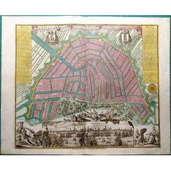
Amsterdam, die weltberuhmte Haupt - und Handel Statt in Holland (..)
A copper engraved map with original hand coloring. Overall size 55 x 68 cm. A beautifully engraved map of Amsterdam, with 2 coat-of-arms, 2 vignettes in the lower corner,...
Date: Augsburg, ca. 1745
Selling price: ????
Please login to see price!
Sold in 2017
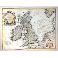
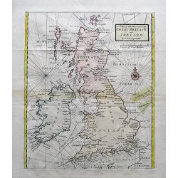
Les Isles Britanniques
A fine example of De L'Isle's map of the British Isles. It was redone by Philippe Buache and published in 1745.Includes a splendid, large, ornate decorative title cartouc...
Date: Paris, 1745
Selling price: ????
Please login to see price!
Sold in 2017
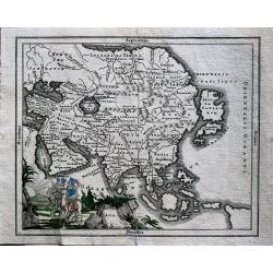
Asia.
Rare, small map of Asia around 1700, unknown author. A proto-Australia is depicted.
Date: ca. 1745
Selling price: ????
Please login to see price!
Sold in 2019
![Die Wahlstadt beij Güntersdorff woselbst des Königs in Preussen Mafestaet den 4ten Junij 1745. . . [Battle of Hohenfriedberg]](/uploads/cache/39375-250x250.jpg)
Die Wahlstadt beij Güntersdorff woselbst des Königs in Preussen Mafestaet den 4ten Junij 1745. . . [Battle of Hohenfriedberg]
A scarce separately issued plan of the Battle of Hohenfriedberg, one of Frederick the Great’s most estimable victories, engraved by the Polish master Bartlomiej Stracho...
Date: Breslau (Wroclaw), Johann Jacob Korn, 1745
Selling price: ????
Please login to see price!
Sold in 2018
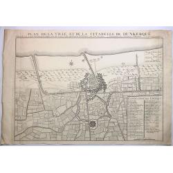
Plan de la Ville et de la Citadelle de Dunkerque.
A striking large example of Covens & Mortier's plan of Dunkerque. The map focuses on the town fortifications and also includes details of the town plan, upper and low...
Date: Amsterdam, 1745
Selling price: ????
Please login to see price!
Sold in 2023
Plan de Charleroy Ville Forte des Pays-Bas dans le Comte de Namur.
A striking example of Covens & Mortier's plan of Charleroy. The map focuses on the town fortifications and includes details of the town plan and environs.The primary ...
Date: Amsterdam, 1745
Selling price: ????
Please login to see price!
Sold in 2019
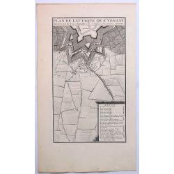
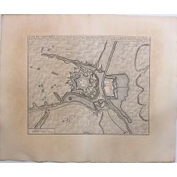
Plan de L'Attaque de St. Venant.
A striking example of Covens & Mortier's plan of St. Venant. The map focuses on the town fortifications and includes details of the town plan and environs. The primar...
Date: Amsterdam, ca. 1745
Selling price: ????
Please login to see price!
Sold in 2019
Ypres, a Strong City and Castle in Flanders.
A detailed plan of the City of Ypres, including fortifications, town plan, roads, farms, rivers, and a decorative compass rose. From Tindal's “Continuation of Rapin's H...
Date: London, 1745
Selling price: ????
Please login to see price!
Sold in 2018
A Map of Karazm, Great Bukharia and Turkestan. . .
A pleasant little map of central Asia by Thomas Kitchin for Astley's "A New General Collection of Voyages and Travels. "Covers from the Caspian Sea across to th...
Date: London, 1745
Selling price: ????
Please login to see price!
Sold in 2019
Plan of the city & Castle of Chester, Survey'd and Drawn by Alexander de Lavaux.
A rare and important plan of the city of Chester was engraved by Parr but surveyed and drawn by a Dutch engineer, Alexandre De Lavaux. Two large and imposing cartouches c...
Date: London, 1745
Selling price: ????
Please login to see price!
Sold in 2017
![Plan de la baye de Manille capitale des isles Philippines située en l'isle Luçon [with] Plan de Pulo Condor ou Isle Condor située à l'extrémité orientale du golfe de Siam [and] Veue de l'Isle Condor. . .](/uploads/cache/39244-250x250.jpg)
Plan de la baye de Manille capitale des isles Philippines située en l'isle Luçon [with] Plan de Pulo Condor ou Isle Condor située à l'extrémité orientale du golfe de Siam [and] Veue de l'Isle Condor. . .
A first edition of the important and large French Sea chart including a chart of Manila Bay, Philippines, accompanied by a chart and view of Côn Son Island, Vietnam by J...
Date: Paris, 1745
Selling price: ????
Please login to see price!
Sold in 2017
Carte réduite de l'archipel des Indes orientales avec les côtes du continent depuis le golfe de Manar jusqu'à Emoui à la Chine . . .
Important French chart of South East Asia with very good detail on Philippines. Latitude and longitude scales, compass rose and system of rhumb lines, soundings near coas...
Date: Paris, 1745
Selling price: ????
Please login to see price!
Sold in 2017
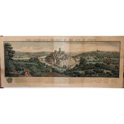
The Southwest Prospect of the City of Durham.
A delightful copperplate engraving of the city of Durham, published in 1745 in London by Samuel and Nathaniel Buck. It shows the ancient city perched high on a hill, over...
Date: London, 1745
Selling price: ????
Please login to see price!
Sold in 2017
A Chart of the Sea Coast of Great Britain and Ireland.
A scarce and attractive sea chart of the British Islands. With many place names along the coats. With a compass rose and rhumb lines.
Date: London, ca. 1745
Selling price: ????
Please login to see price!
Sold in 2017
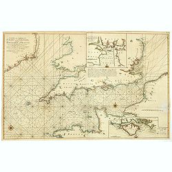
A new and correct chart of the channel between England & France..
The chart includes the South Coast of England from North of the Bristol Channel and of the Thames Estuary, there are insets for Plymouth Sound and the Isle of Wight.
Date: London, 1745
Selling price: ????
Please login to see price!
Sold in 2018
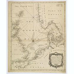
A correct Chart of the German Ocean from the North of Scotland to the Start Point. . .
A large sea chart of the eastern half of the English Channel, the eastern coasts of England and Scotland, the French coast from Normandy and the Channel Islands, up throu...
Date: London, 1745
Selling price: ????
Please login to see price!
Sold in 2020

Atlas Novus ad Usum Serenissimi Burgundiae Ducis.
Title page of the homonymous atlas by Jean Covens and Corneille Mortier. Blank verso. Soldiers, savages and other individuals are shown approaching a queen seated on her ...
Date: Amsterdam c. 1745
Selling price: ????
Please login to see price!
Sold in 2021
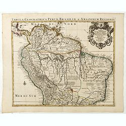
Carte de la Terre Ferme du Perou, du Bresil et du Pays des Amazones.
Large, graphic map of the northern part of South America. It is filled with place names and notations speculating about the Indian tribes and the tributaries to the Amazo...
Date: Amsterdam c. 1745
Selling price: ????
Please login to see price!
Sold in 2020