Browse Listings
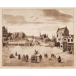
Oud gezigt van.. De Vijverberg, en 's-Gravenhof ..
"A very decorative view of the Vijverberg and ""Buitenhof"" in center of The Hague."
Date: The Hague 1736
Selling price: ????
Please login to see price!
Sold
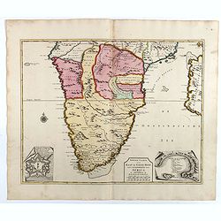
![[The Holy Land]](/uploads/cache/13971-250x250.jpg)
[The Holy Land]
A very nice map of Palestine, oriented with east at the top, showing the tribal divisions. Designed to illustrate the Old Testament, numerous notations are made througho...
Date: England, 1736
Selling price: ????
Please login to see price!
Sold in 2009
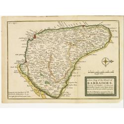
A New Map of the Island of Barbadoes, Containg all ye Parishes..
Small appealing map of the island of Barbados, very detailed showing roads, paths, villages, settlements and more.Barbados is in the Lesser Antilles off the coast of Vene...
Date: London 1736
Selling price: ????
Please login to see price!
Sold
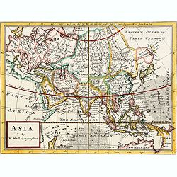
Asia By H.Moll Geographer.
Detailed map of Asia. From his "Atlas minor: or a new and curious set of sixty-two maps. . .", which was first published in 1729 and reprinted in 1732, 1736.The...
Date: London, 1736
Selling price: ????
Please login to see price!
Sold in 2024
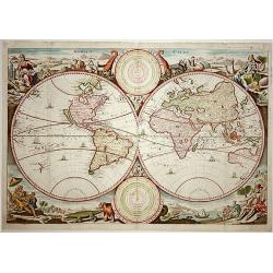
Werelt Caert. Orbis terrarum
Lovely double hemisphere map from a Dutch Bible. Title inside the surrounding allegorical representations of the continents, based on Visscher. CALIFORNIA IS AN ISLAND wi...
Date: Amsterdam, 1736
Selling price: ????
Please login to see price!
Sold in 2008
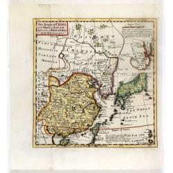
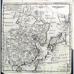
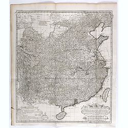
The Empire of China and Island of Japan, Agreeable to Modern History by H.Moll.
From the third edition of his Atlas Minor. This state of the map has page number 37 added in the upper right corner of the scale. Underneath the scale, a description of H...
Date: London, Thos. Bowles and John Bowles, 1736
Selling price: ????
Please login to see price!
Sold in 2016
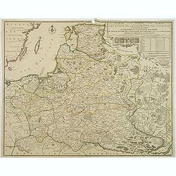
Les Etats de la couronne de Pologne. . .
Rare 1736 edition of De Fer's map of Poland, Lithuania and the Ukraine.The map is bounded by the Baltic, Muscovy, the Dniester and the Oder Rivers and extends to the Pala...
Date: Paris, 1736
Selling price: ????
Please login to see price!
Sold in 2011
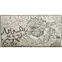
Neu- eröffnetes Welt- und Staats- Theatrum... (WITH 2 RARE MAPS OF AZOV)
Scarce book containing two rare maps of the city of Azov on the Don River. Further illustrated by 18 engraved portraits and views! With nicely drawn portraits of Kings a...
Date: Erfurt, 1736
Selling price: ????
Please login to see price!
Sold in 2012
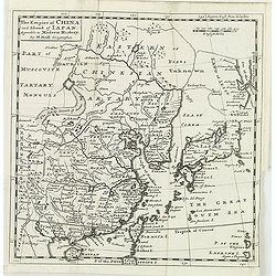
The empire of china and island of Japan.
The map is of interest for the use of East Sea, the sea between Korea and Japan, here called "Sea of Korea". From his atlas "Atlas minor or a new and curio...
Date: London, 1736
Selling price: ????
Please login to see price!
Sold in 2012
The Empire of China and Island of Japan.
The map is of interest for the use of East Sea, the sea between Korea and Japan, here called "Sea of Korea". From his atlas "Atlas minor or a new and curio...
Date: London, 1736
Selling price: ????
Please login to see price!
Sold in 2012
Nouvelle Carte du golfe de Marseille.
Highly detailed, very large, copper engraved map depicting the bay of Marseille. The map is oriented with North on bottom right and decorated with a large compass rose. ...
Date: Paris, 1736
Selling price: ????
Please login to see price!
Sold in 2014
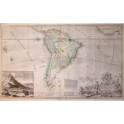
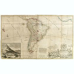
Map of South America, according to the Newest and most exact observations. . .
From 'The World described'. The elaborate cartouche designed by Bernard Lens and engraved by George Vertue is balanced by a large (8 x 10) inset view of Potosi with a not...
Date: London, 1736
Selling price: ????
Please login to see price!
Sold in 2015
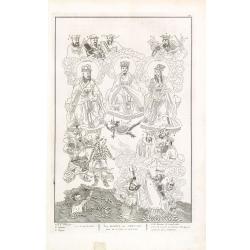
Les Dieux des Chinois tirés de la Chine de Kircher.
Fascinating engraving depicting Chinese idols and Gods. Engraved by Bernard Picard after Kircher.Published in Jean Frederic Bernard's monumental "Cérémonies et cou...
Date: Amsterdam, J.F. Bernard c.1736
Selling price: ????
Please login to see price!
Sold in 2013
Magiciens et Sorciers de la Chine. Autres Magiciens & Sorciers. &c.
Fascinating engraving depicting Chinese mystics. The second scene features a Chinese dragon. Engraved by Bernard Picard. Published in Jean Frederic Bernard's monumental &...
Date: Amsterdam, J.F. Bernard c.1736
Selling price: ????
Please login to see price!
Sold in 2013
Religieux et gueux dévots des Chinois. Planche n° 9. Lamas, prêtres des Tartares. — Prêtres mendians des Chinois. — Châtiment et punition pour avoir . . .
Fascinating engraving depicting Lamas Priests. Engraved by Bernard Picard. Published in Jean Frederic Bernard's monumental "Cérémonies et coutumes religieuses de t...
Date: Amsterdam, J.F. Bernard c.1736
Selling price: ????
Please login to see price!
Sold in 2013
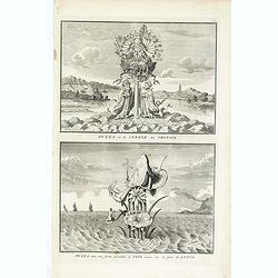
Puzza ou la Cybele des Chinois - Puzza sous une forme parallèle à Isis assise sur la fleur de lotus, du livre illustré Cérémonies et coutumes religieuses
Two fascinating engraving on one sheet depicting a Chinese religious ceremony with a pagoda in the background. Engraved by Bernard Picard. Published in Jean Frederic Bern...
Date: Amsterdam, J.F. Bernard c.1736
Selling price: ????
Please login to see price!
Sold in 2014
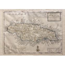
The Island of Jamaica Divided into its Principal Parishes with the Roads & c.
The Island of Jamaica Divided into its Principal Parishes with the Roads & c. by Herman Moll. A highly detailed map of the island engraved with mountains, roads, town...
Date: London, 1736
Selling price: ????
Please login to see price!
Sold in 2016
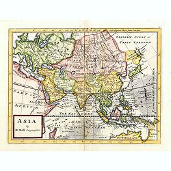
Asia By H.Moll Geographer.
Detailed map of Asia. From his "Atlas minor: or a new and curious set of sixty-two maps. . .", which was first published in 1729 and reprinted in 1732, 1736.The...
Date: London, 1736
Selling price: ????
Please login to see price!
Sold in 2015
To the right honourable Charles Earl of Sunderland and Beron Spencer of Wormleighton. . . This map of South America. . .
Map of South America including part of Central America. Cartographic elements include lines of latitude and longitude, compass rose, indication of wind directions, locati...
Date: London, 1726-1736
Selling price: ????
Please login to see price!
Sold in 2015
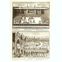
Jugement de l'Inquisition dans la grande Place de Madrid. / Procession de L'Inquisition a GOA.
Fascinating engraving depicting Spanish inquisitions in Madrid and Goa. Engraved by Bernard Picard after Kircher.Published in Jean Frederic Bernard's monumental "Cé...
Date: Amsterdam, J.F. Bernard c.1736
Selling price: ????
Please login to see price!
Sold in 2015

Philip II, King of Spain, Naples, Sicilie &c.
A fine hand colored copper engraving of Philip II. Engraved by Vertue from a painting by Titian. From Rapin's "HISTORY OF ENGLAND" IN 1736. The portrait is surr...
Date: London, 1736
Selling price: ????
Please login to see price!
Sold in 2016
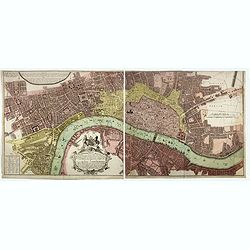
Urbium Londini et West-Monasterii nec non Surburbii Southwark Accurata Ichnographia ... Neuester Grundris der Staedte London und West-Munster, Samt der Vorstadt Southwark ...
Detailed plan of London. Ornamental title cartouche surmounted by the royal arms of George II, with a note in Latin and German within semi-elliptical banner, glossary of ...
Date: Nuremberg, 1736
Selling price: ????
Please login to see price!
Sold in 2017
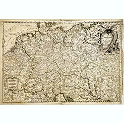
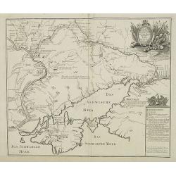
Imperii Moscovitici pars Australis. . .
A detailed map of the southern part of the Russian Empire, after De L'Isle. It extends from Moscow south to the Ukraine and east to Astrakan. It is a detailed map centere...
Date: Augsburg, ca. 1736
Selling price: ????
Please login to see price!
Sold in 2018
Père Matthieu Ricci / Père Adam Schaal / Père Ferdinand Verbiest.
Folding plate of the 3 most important missionary cartographers who worked in China from Jean Baptiste Du Halde's "Description géographique, historique, chronologiqu...
Date: The Hague, Henri Scheurleer, 1736
Selling price: ????
Please login to see price!
Sold in 2018
Nouvel atlas de la Chine, de la Tartarie chinoise, et du Thibet.
First edition of "the principal cartographic authority on China during the 18th century". It was the second major atlas of China produced in Europe following th...
Date: The Hague, H. Scheurleer, 1737
Selling price: ????
Please login to see price!
Sold
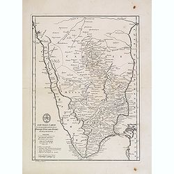
Nouvelle carte d'une grande partie de la presqu'île des Indes en deça du Gange . . .
Uncommon map of the pen insular of India prepared by Jean-Baptiste Bourguignon d' Anville (1697-1782) after Jesuit sources. The map is dated 1737 and carries the sign of ...
Date: Paris, 1737
Selling price: ????
Please login to see price!
Sold in 2012
Carte des Pays traverses par le Cap.ne Beerings depuis la ville de Tobolsk jusqu'à Kamtschatka
With a quite elaborately pictorial cartouche, engraved by G.Kondet. Showing the northern coast of Chine, Strait Beering. This map includes the first printed configuration...
Date: The Hague, 1737
Selling price: ????
Please login to see price!
Sold in 2012
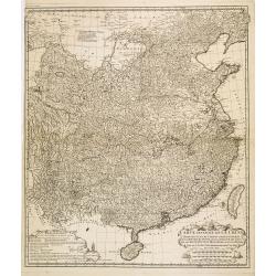
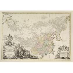
Carte générale de la Chine Dressée sur les Cartes particulières que l'Empereur Cang-hi a fait lever sur les lieux par les RR. PP. Jésuites missionaires dans cet empire / Par le Sr d'Anville.
Important and very detailed map of Southern part of China, including a detailed Taiwan. Jean Baptiste Bourguignon d' Anville (1697-1782) was a French cartographer and com...
Date: The Hague, H. Scheurleer, 1737
Selling price: ????
Please login to see price!
Sold in 2013
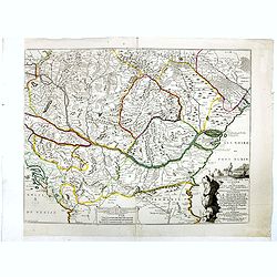
L'Allemagne et ses frontieres comprenant le theatre de la guerre. . .
A scarce map of Germany, Poland, The Low Countries, Switzerland, Austria, Northern Italy, etc. showing the Theater of War in the Holy Roman Empire.
Date: Paris, 1737
Selling price: ????
Please login to see price!
Sold in 2014
Nouvelle carte d'une grande partie de la presqu'île des Indes en deça du Gange / dressée sur deux cartes manuscrites des RR. PP. Jésuites par le Sr. d'Anville.
Uncommon map of the pen insular of India prepared by Jean-Baptiste Bourguignon d' Anville (1697-1782) after Jesuit sources. The map is dated 1737 and carries the sign of ...
Date: Paris, 1737
Selling price: ????
Please login to see price!
Sold in 2013
The Citadel Of Plymouth.
A magnificent panoramic view of the citadel at Plymouth which was built in 1665. The view is dedicated to the "Hon. Charles Churchill Esqr. Major General Of His Maje...
Date: London, 1737
Selling price: ????
Please login to see price!
Sold in 2014
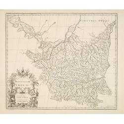
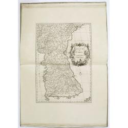
Province de Chen-Si.
With a quite elaborately pictorial cartouche, engraved by Guélard, the map by Delahaye. Jean Baptiste Bourguignon d' Anville (1697-1782), French cartographer. Compiled o...
Date: The Hague, 1737
Selling price: ????
Please login to see price!
Sold in 2014
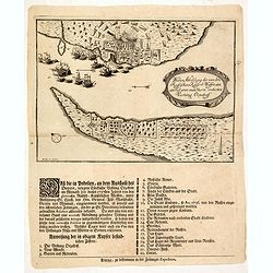
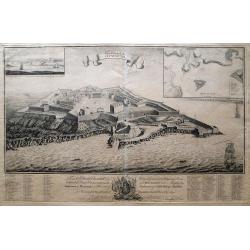
Wahre abbildung der von den Russischen keijserl: Waffen am 13 Jul: 1737 mit Sturm eroberten Vestung Oczakoff.
Rare broadsheet with an expertly engraved plan (210 x 290mm.) of the Russian siege of Oczaków at 13 July 1737. Turkish vessels in the Black Sea leaving the town.In lower...
Date: Leipzig, 1737
Selling price: ????
Please login to see price!
Sold in 2014
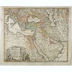
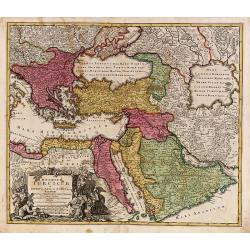
Imperium Turcicum in Europa, Asia et Africa.
Johann Baptist Homann's well-engraved map of the Turkish Empire with a fine decorative title cartouche. Johann Baptist Homann (1663-1724) was a German engraver and publis...
Date: Nurnberg, 1737
Selling price: ????
Please login to see price!
Sold in 2017
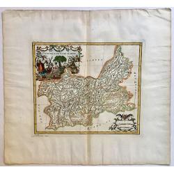
Province de Koei-Tcheou.
Appeared in d'Anville's Nouvel atlas de la Chine in 1737. This is a delightful map of the province of Guizhou, or Kweichow, the smallest province in southwestern China. T...
Date: 1737
Selling price: ????
Please login to see price!
Sold in 2017
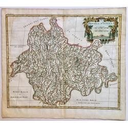
Province d'Yunnan.
Based on Jesuit sources, D'Anville's maps remained the definitive European rendering of China's provinces until the end of the 19th century. This beautiful and detailed D...
Date: 1737
Selling price: ????
Please login to see price!
Sold in 2017
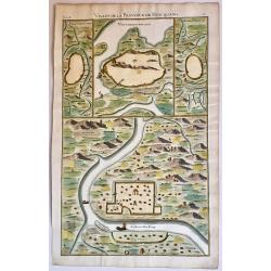
Villes de la Province de Hou-Quang.
A nice example of d'Anville's local town plans of Hubei Province, China from 1737. Includes 4 town plans, including Wuhan, called Vou-Tchang-Fou and a nice map of the Yan...
Date: 1737
Selling price: ????
Please login to see price!
Sold in 2017
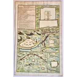
Villes de la Province de Petcheli.
A nice example of d'Anville's local plans of the region around Peking, China in 1737. Shows a town plan of the Forbidden City in Peking, the Great Wall of China, and othe...
Date: 1737
Selling price: ????
Please login to see price!
Sold in 2017
Le théâtre de la guerre sur les frontières des deux empires depuis Vienne jusques à Constantinople, où se trouvent la Hongrie, la Transilvanie,
Nicolas De Fer's map of the Theater of War showing the region between Vienna and Constantinople, included are Hungary, Bulgaria, Wallachia, Transylvania, Bosnia and Serbi...
Date: Paris, Bernard, 1737
Selling price: ????
Please login to see price!
Sold in 2019
Carte du cours de la Riviere de Meinam depuis Judia jusqui..
Very rare single sheet map of the Meinam river delta from the ancient capital Juthia, shown in inset top left with its continuation on the larger map to the sea. A compli...
Date: Amsterdam, 1737
Selling price: ????
Please login to see price!
Sold in 2017
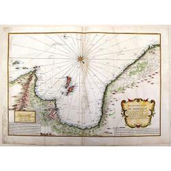
Nieuwe caarte van Kaap de Goede Hoop en't zuyderdeel van Africa. . .
Uncommon map of Africa, south of the Equator, with insets of the Dutch fort at the Cape of Good Hope and Table Bay.Joachim Ottens (1663 - 1719) and his sons Renier and Jo...
Date: Amsterdam, 1737
Selling price: ????
Please login to see price!
Sold in 2017
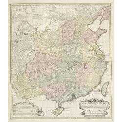
Carte Generale de la Chine Dressée sur les Cartes Particulieres Que l' Empereur Chang-Hi a fait lever sur les lieux..
Large map showing the traditional limits of China, including Hainan and Formosa in the South, and Quantong and parts of the Gobi Desert in the North.As the title notes, t...
Date: Paris , 1737
Selling price: ????
Please login to see price!
Sold in 2018
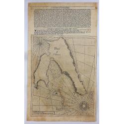
Island of St. Peters.
An early nautical chart of the island of St Pierre, included in the territory of Saint Pierre and Miquelon, by Mount and Page in London in 1737. Relief shown by hachures,...
Date: London, 1737
Selling price: ????
Please login to see price!
Sold in 2018
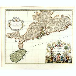
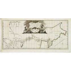
Province de Quang-Tong.
With a quite elaborately pictorial cartouche, engraved by G.Kondet. Very detailed map of Hong Kong and its surroundings. Jean Baptiste Bourguignon d' Anville (1697-1782),...
Date: The Hague 1737
Selling price: ????
Please login to see price!
Sold in 2018
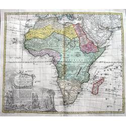
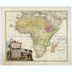
Africa secundum legitimas Projectionis...
Decorative map of Africa, with a large title cartouche featuring the Dutch at the Cape of Good Hope, Table Mountain, elephants, lions and snakes. Homann focuses on the kn...
Date: Nuremberg, ca. 1737
Selling price: ????
Please login to see price!
Sold in 2018
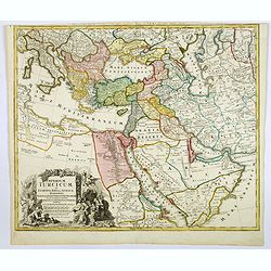
Imperium Turcicum in Europa, Asia et Africa.
Johann Baptist Homann's well-engraved map of the Turkish Empire with a fine decorative title cartouche. Striking map of the Turkish Empire stretching from the Balkan peni...
Date: Nurnberg, 1737
Selling price: ????
Please login to see price!
Sold in 2019
A Map of the British Empire in America with the French Spanish and Hollandish Possessions adjacent thereto by Henry Popple.
This is the one-sheet key map from the Dutch edition. 22 insets and views of various harbors and sights. This example is the rare FIRST state of the edition published by ...
Date: Amsterdam, 1737
Selling price: ????
Please login to see price!
Sold in 2020
Africa Secundum legitimas Projectionis Sterographicae regulas. . .
Johann Matthias Haas's revision J.B. Homann's 1715 map of Africa, augmented to include important cartographic developments as recorded by Guillaume Delisle and D'Anville....
Date: Nuremberg, ca 1737
Selling price: ????
Please login to see price!
Sold in 2019
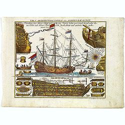
Tab.V. Architectura Navalis oder Schiffs-Bau-Kunst.
An attractive and interesting naval plate by L.M. Steinberger, produced for Hubner's Reales Staats-Zeitungs und Conversations-Lexicon. . .This is plate 5 from the work an...
Date: Leipzig, 1737
Selling price: ????
Please login to see price!
Sold in 2019
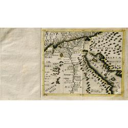
Aegyptus Antiqua.
A rare map of Egypt by Franz Wagner (historian and Jesuit), from "Einleitung in die alte und neuere Geographia". Published and printed by Leopold Hoedl and Fran...
Date: Vienna, ca. 1737
Selling price: ????
Please login to see price!
Sold in 2019
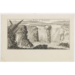
Fall of Niagara.
View of Niagara Falls, taken from the six sheet Dutch edition of Popple's monumental map the British Empire in America .
Date: Amsterdam, 1737
Selling price: ????
Please login to see price!
Sold in 2021
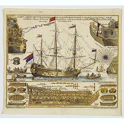
Tab.V. Architectura Navalis oder Schiffs-Bau-Kunst.
An attractive and interesting naval plate by L.M. Steinberger, produced for Hubner's Reales Staats-Zeitungs und Conversations-Lexicon. . .This is plate 5 from the work an...
Date: Leipzig, 1737
Selling price: ????
Please login to see price!
Sold in 2020
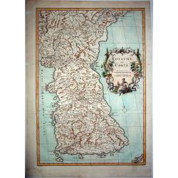
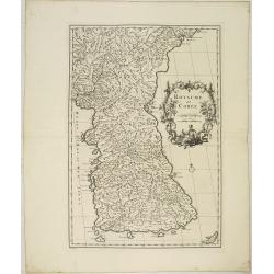
ROYAUME DE COREE.
The first separate map of Korea by a European cartographer. A fine engraved map of Korea, the title within a fine rococo historiated cartouche middle right, decorated wit...
Date: Paris, 1737
Selling price: ????
Please login to see price!
Sold in 2021
Kriegs- Ingenieur u. Artillerie Charte
A large impressive and rare print showing various fortifications, weapons, palisades etc. including explanations on the art of besieging cities and fortifications. By Joh...
Date: Nuremberg, 1737
Selling price: ????
Please login to see price!
Sold in 2022
![[Title page] Atlas Novus Terrarum Orbis Imperia. . .](/uploads/cache/48127-250x250.jpg)
[Title page] Atlas Novus Terrarum Orbis Imperia. . .
The lovely title page from Homann's Grosser Atlas uber de Gantsa Welt (Grand Atlas of all the World)with striking color and features. It shows Atlas and Hercules / Herakl...
Date: Nuremberg, ca 1737
Selling price: ????
Please login to see price!
Sold in 2022
![Province de Fo-Kien. [Includes West Coast of Taiwan]](/uploads/cache/29547-250x250.jpg)
Province de Fo-Kien. [Includes West Coast of Taiwan]
Important map of Fujian Province, showing the east coast of China and the west coast of Taiwan. It shows that for the Manchu Qing, only the western half of Formosa was co...
Date: The Hague, H. Scheurleer, 1737
Selling price: ????
Please login to see price!
Sold
Imperium Turcicum in Europa, Asia et Africa.
Johann Baptist Homann's well-engraved map of the Turkish Empire. With fine decorative title cartouche. Johann Baptist Homann (1663-1724) was a German engraver and publish...
Date: Nurnberg 1737
Selling price: ????
Please login to see price!
Sold
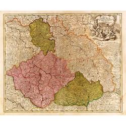
Regni Bohemiae Ducatus Silesiae..
"Johann Baptist Homann's well-engraved map of the Czechoslovakia and southern part of Poland. With fine decorative title cartouche. Johann Baptist Homann (1663-1724)...
Date: Nurnberg 1737
Selling price: ????
Please login to see price!
Sold
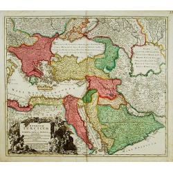
Imperium Turcicum in Europa, Asia et Africa.
Johann Baptist Homann's well-engraved map of the Turkish Empire. With fine decorative title cartouche. Johann Baptist Homann (1663-1724) was a German engraver and publish...
Date: Nurnberg 1737
Selling price: ????
Please login to see price!
Sold
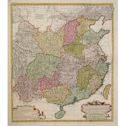
Carte Generale de la Chine..
Very detailed map of Southern part of China, including a detailed Taiwan. Jean Baptiste Bourguignon d' Anville (1697-1782), French cartographer. Compiled over 200 maps. T...
Date: The Hague, 1737
Selling price: ????
Please login to see price!
Sold in 2009
Royaume de Corée.
With a quite elaborately pictorial cartouche, engraved by G.Kondet. One of the earliest separate maps of Korea. Jean Baptiste Bourguignon d' Anville (1697-1782), French c...
Date: The Hague, 1737
Selling price: ????
Please login to see price!
Sold
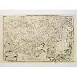
Carte Generale de la Tartarie Chinoise..
Very detailed map of Northern China, Japan and Korea. Jean Baptiste Bourguignon d' Anville (1697-1782), French cartographer. Compiled over 200 maps. This map is from his ...
Date: Paris 1737
Selling price: ????
Please login to see price!
Sold
Carte Generale De La Tartarie Chinoise Dressee sur les Cartes Particulieres Faits Sur Les Lieux Par Les R.R. P.P. Jesuites . . . .MDCCXXXII
D'Anville is very important for Korean cartography as he made the cartography of Korea widely available. The map is the first fairly accurate western map of Korea, though...
Date: The Hague, 1732-1737
Selling price: ????
Please login to see price!
Sold
Charte der Kriegs Operationen am Donn und Dnieper. Ihro Russisch Key Serl: Maiesty: gloriousen Armeen A 1736. . .
Very rare map of the southern part of Ukraine, with an explanatory key A-N in lower right. One of five maps (see also Atlas Ukrainae et Ponti Euxini, 41 - 44) published b...
Date: St. Petersburg, c. 1736-1737
Selling price: ????
Please login to see price!
Sold in 2011
Xe feuille de la Tartarie Chinoise, contenant le Païs de KE-TCHING, l'embouchure du SAGHALIEN-OULA dans la Mer orientale, . . .
One of the earliest detailed maps of the region from "Nouvel atlas de la Chine, de la Tartarie chinoise et du Thibet : contenant les cartes générales & particu...
Date: The Hague, H. Scheurleer, 1737
Selling price: ????
Please login to see price!
Sold in 2015
Prospectus Celsissimi..
Engraved by Corvinus after a design of Salomon Kleiner. From Vera et accurata delineatio Omnium Templorum et Coenobiorum, Quae tam in Caesarrea Urbe ac Sede Vienna Austri...
Date: Augsburg, 1737
Selling price: ????
Please login to see price!
Sold in 2010
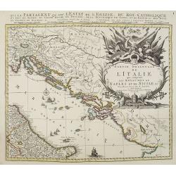
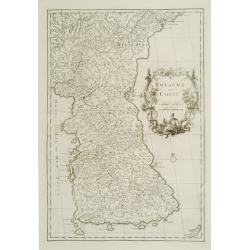
Partie orientale de L'Italie qui comprend les Royaumes de Naples et de Sicile. . .
Map of former Yugoslavia and the eastern part of Italy with a splendid baroque title cartouche with mythological figures. Title : Partie orientale de L'Italie qui compren...
Date: Amsterdam, ca. 1737
Selling price: ????
Please login to see price!
Sold in 2010
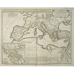
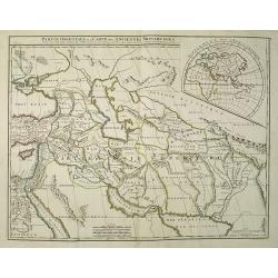
Carte pour servir à la lecture de l'histoire ancienne des Egyptiens, des Carthaginois, des Assyriens, des Babyloniens, des Medes, des Perses, des Macedoniens, des Grecs: par M. Rollin ancien recteur de l'université de Paris.
This map depicts the western part of the Ancient World, Partie Occidentale de la Carte des Anciennes Monarchies including southern Europe and northern Africa. An inset ma...
Date: Paris, 1737
Selling price: ????
Please login to see price!
Sold in 2009
Carte pour servir à la lecture de l\'histoire ancienne des Egyptiens, des Carthaginois, des Assyriens, des Babyloniens, des Medes, des Perses, des Macedoniens, des Grecs: par M. Rollin ancien recteur de l\'université de Paris.
This map depicts shows the eastern portion Partie Occidentale de la Carte des Anciennes Monarchies including the Middle East, Persia and the Indus River Valley. An inset ...
Date: Paris, 1737
Selling price: ????
Please login to see price!
Sold in 2009
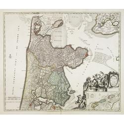
Hollandiae Septentrionalis & Frisiae Occidentalis. . .
Map of the Dutch region of North Holland between Amsterdam, Enkhuizen and Texel island. Large figurative cartouche and inset map of the islands Texel, Vlieland and Tersch...
Date: Amsterdam, ca. 1737
Selling price: ????
Please login to see price!
Sold in 2009
Royaume de Corée.
With a quite elaborately pictorial cartouche, engraved by G.Kondet. One of the earliest separate maps of Korea. Jean Baptiste Bourguignon d' Anville (1697-1782), French c...
Date: The Hague, 1737
Selling price: ????
Please login to see price!
Sold in 2010
Carte générale de la Chine Dressée sur les Cartes particulières que l'Empereur Cang-hi a fait lever sur les lieux par les RR. PP. Jésuites missionaires dans cet empire / Par le Sr d'Anville.
Important and very detailed map of Southern part of China, including a detailed Taiwan. Jean Baptiste Bourguignon d' Anville (1697-1782) was a French cartographer and com...
Date: The Hague, H. Scheurleer, 1737
Selling price: ????
Please login to see price!
Sold
Nouvel atlas de la Chine, de la Tartarie chinoise, et du Thibet.
First edition of "the principal cartographic authority on China during the 18th century". It was the second major atlas of China produced in Europe following th...
Date: The Hague, 1737
Selling price: ????
Please login to see price!
Sold
![[10 Maps] Carte generale du Thibet ou Bout-Tan et des Pays de Kashgar et Hami Dress'ee sur les Cartes et Memoires des RR PP Jesuites de la Chine . . .](/uploads/cache/28752-250x250.jpg)
[10 Maps] Carte generale du Thibet ou Bout-Tan et des Pays de Kashgar et Hami Dress'ee sur les Cartes et Memoires des RR PP Jesuites de la Chine . . .
The first accurate cartographic depiction of Tibet available in the western world. Jean Baptiste Bourguignon d' Anville (1697-1782), French cartographer. Compiled over 20...
Date: The Hague, 1737
Selling price: ????
Please login to see price!
Sold in 2010
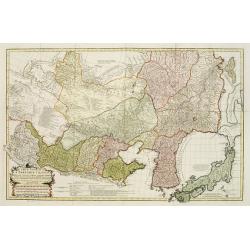
Carte la plus generale et qui comprend la Chine, la Tartarie chinoise et le Thibet. . .
With a quite elaborately pictorial cartouche, engraved by G.Kondet. Very detailed map of China, Tibet and Korea. Jean Baptiste Bourguignon d' Anville (1697-1782), French ...
Date: Paris, 1737
Selling price: ????
Please login to see price!
Sold in 2010
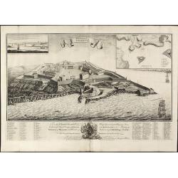
The Citadel of Plymouth.
Rare view of the Citadel of PlymouthA large and impressive copper engraved view of the Citadel of Plymouth, draw by Sandford Mace and engraved by Charles Mosley. Shows th...
Date: London, dated July 25th, July 1737
Selling price: ????
Please login to see price!
Sold in 2010
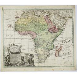
AFRICA Secundum legitimas Projectionis Stereographiae regulas . . Leonis Africani. . .à IOH. MATTHIA HASIO. . .
A large, nice copper engraved map of Africa, and Madagascar, with Arabia, dated 1737, by Jean-Baptiste HOMANN (1664-1724) & Johann Mathias Hass, edited by Homann Heir...
Date: Nuremberg, ca 1737
Selling price: ????
Please login to see price!
Sold in 2018
![Carte generale de la Chine. . . [together with 11 maps of Chinese provinces]](/uploads/cache/29994-250x250.jpg)
Carte generale de la Chine. . . [together with 11 maps of Chinese provinces]
Very detailed map of Southern part of China, including a detailed Taiwan. Together with 11 maps of Chinese provinces, in different sizes and each with a fine title cartou...
Date: The Hague, 1737
Selling price: ????
Please login to see price!
Sold in 2010
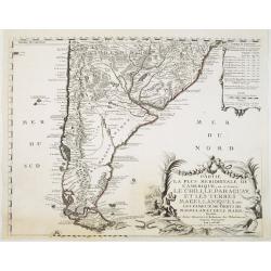
Partie la plus Meridionale de L'Amerique..
Striking map of the southern tip of south America: Prepared by Nicolas de Fer and published by Danet. Engraved by De Rochefort (signed lower right). The map shows the maj...
Date: Paris, Danet, 1737
Selling price: ????
Please login to see price!
Sold in 2022
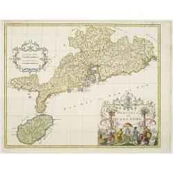
Province de Quang-Tong.
With a quite elaborately pictorial cartouche, engraved by D.Sornique. Very detailed map of Hong Kong and its surroundings. Jean Baptiste Bourguignon d' Anville (1697-1782...
Date: The Hague, 1737
Selling price: ????
Please login to see price!
Sold in 2011