Browse Listings
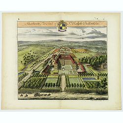
Sherborne, The Seat of Sir Ralph Dutton Bart.
The noted Dutch draughtsman and engraver, Johannes Kip (1653-1722) engraved this handsome topographical copperplate engraving for inclusion within Sir Robert Atkyns’s T...
Date: London, ca 1712
Selling price: ????
Please login to see price!
Sold in 2020
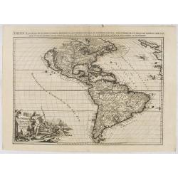
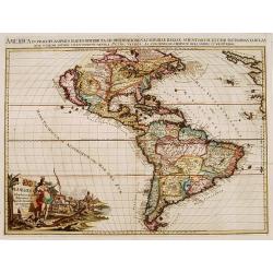
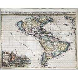
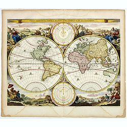
L'Amerique Selon les nouvelles Observations de Messrs de l'Academie des Scineces etc.
Scarce map. Pieter van der Aa's lavish engraving makes his maps among the most prized of the early eighteenth century. This is one of the most attractive and superbly eng...
Date: Leiden, 1713
Selling price: ????
Please login to see price!
Sold in 2020
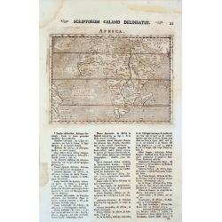
AFRICA.
This the Raphael Savonarola printing of Giovanni Magini's modern map of Africa, from his edition of Claudius Ptolemy's Geographia. It is basically a slightly-reduced ve...
Date: Padua, 1713
Selling price: ????
Please login to see price!
Sold in 2013
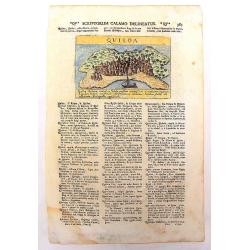
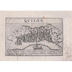
Quiloa
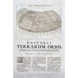
An uncommon, important map of Kilwa , an island off the coast of East Africa, in present day Tanzania. It is from Lazor A Varea's "Universus Terrarum Orbis". A ...
Date: Padua, 1713
Selling price: ????
Please login to see price!
Sold in 2013
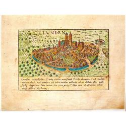
Lunden.
A quaint little city view of the town Lunden in Germany. Engraved for Francesco Valegio's townbook: "Raccolta di le piv illustri et farmose citta di tutto il mondo.&...
Date: Venice, 1600 or 1713
Selling price: ????
Please login to see price!
Sold in 2014
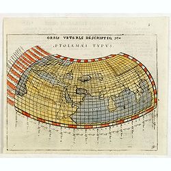
Orbis Veteris Descriptio, seu Ptolemaei Typus.
A Ptolemaic map engraved by Giovanni Antonio Magini. The landlocked Indian Ocean contains a huge Toprobana (present day Sri Lanka) and a virtually nonexistent Indian subc...
Date: Padua, 1713
Selling price: ????
Please login to see price!
Sold in 2015
Orbis Veteris Descriptio, seu Ptolemaei Typus.
Ptolemaic map of the old world, showing the Indian Ocean surrounded by land! With a huge Toprobana (present day Sri Lanka) and a virtually nonexistent Indian subcontinent...
Date: Padova, c. 1713
Selling price: ????
Please login to see price!
Sold in 2015
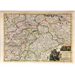
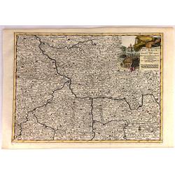
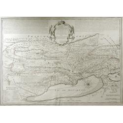
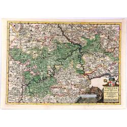
Cercle de la Haute Saxe...
This quaint map shows the Upper Saxon Circle according to the latest map of Pierre Van der Aa. The area encompasses parts of Saxony, Thuringia and Saxony-Anhalt. Central ...
Date: Leiden, 1713
Selling price: ????
Please login to see price!
Sold in 2018
Cercle Electoral du Rhin...
"Cercle Electoral du Rhin. Suivant les Nouvelles Observations de Mess.rs de l'Academie Royale des Sciences, etc. Augmentees de Nouveau. / Cercle du Haut Rhin. Suivan...
Date: Leiden, 1713
Selling price: ????
Please login to see price!
Sold in 2020
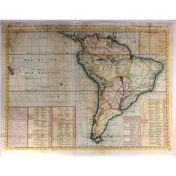
Nouvelle Carte de Geographie de la Partie Meridionale de l'Amerique Suivant les Plus Nouvelles Observations
A striking large map of South America, with information about various discoveries, expeditions, and colonies. In the Pacific, the routes of Magellan, Schouten & Le Ma...
Date: Paris, 1713
Selling price: ????
Please login to see price!
Sold in 2016
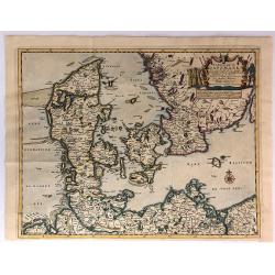
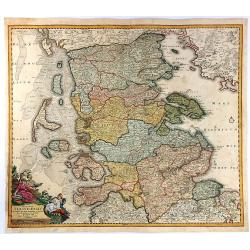
Le Royaume de Danemark Avec Une Partie de la Suede.
A detailed map of Denmark and southwestern Sweden, published by Van der Aa in his “Le Nouveau Theatre du Monde . . . .” This bold map of Denmark and southern Sweden s...
Date: Leiden, 1713
Selling price: ????
Please login to see price!
Sold in 2018
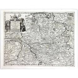
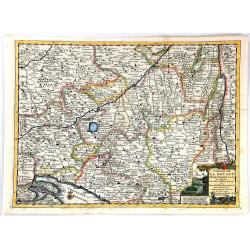
Cercle de Westphalie.
A detailed map by Pierre van der Aa of the German province of Westphalie, following the new observations of the “Academie Royale des Sciences”. It has a beautiful car...
Date: Leiden, 1713
Selling price: ????
Please login to see price!
Sold in 2016
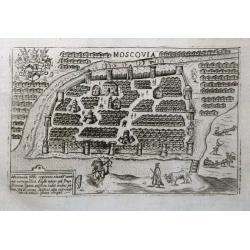
Moscovia.
An early plan of Moscow set on a page with latin text. Small but detailed view with many buildings, the city fortifications, and figures including a mounted archer. On th...
Date: Padua, 1713
Selling price: ????
Please login to see price!
Sold in 2016
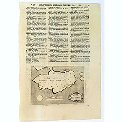
Piccola Tartaria.
A basic map of the Crimea, with little detail shown. Small strap-work cartouche, set in a text page with Latin text. Taken from "Universus Terrarum Orbis", prin...
Date: Padua, Lasor a Varea, 1713
Selling price: ????
Please login to see price!
Sold in 2016
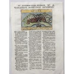
Quiloa.
A charming map of the island nation of Quiloa (Kilwa) off the coast of East Africa, in present day Tanzania near Zanzibar. An attractive small city view (after Valegio) ...
Date: Padua, 1713
Selling price: ????
Please login to see price!
Sold in 2017
Quiloa (Kilwa - Tanzania)
A woodcut print of Quiloa (Kilwa) off the coast of Tanzania. An scarce small map of the island.
Date: Padua, 1713
Selling price: ????
Please login to see price!
Sold in 2018
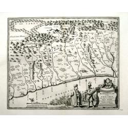
Mingrelie, autrefois Colchis, Pays baigné au Couchant par la Mer Noire.
A rare map of the ancient kingdom of Colchis, in the region of Mingrelia, on the coast of the Black Sea, in Western Georgia. It is oriented to the northeast. Shows place ...
Date: Leiden, 1713
Selling price: ????
Please login to see price!
Sold in 2019
Moraviae Nova et post omnes priores accuratissima delineatio.
The cartographer of this map was Johan Amos Comenius (1592-1670), Czech cartographer and priest. In the upper part four views of Polna, Olmuts, Brin and Znaim.The sixth s...
Date: Amsterdam, between 1680 and 1713
Selling price: ????
Please login to see price!
Sold in 2021
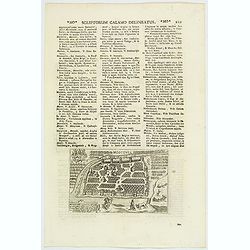
Moscovia / Moscovia Imperium.
An early plan of Moscow, set in text, first published ca.1600, with the buildings wonderfully shown in perspective. Based on the Braun & Hogenberg map, it is decorate...
Date: Padua, 1713
Selling price: ????
Please login to see price!
Sold in 2020

Partie Meridionale de Champagne ...
A striking map of the southern part of the Champagne Region in France by Guillaume De L'isle. It covers the Champagne-Ardenne and the Ile-de-France regions in northeast F...
Date: Amsterdam, 1713
Selling price: ????
Please login to see price!
Sold in 2019
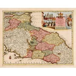
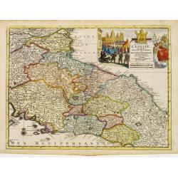
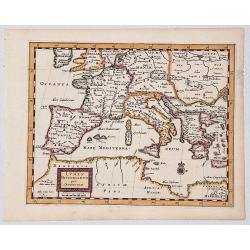
L'Etat de L'Eglise..
Although not renowned for the originality of his work, Pieter van der Aa is highly thought of for the design and quality of his output. Showing central part of Italy. Its...
Date: Amsterdam 1713
Selling price: ????
Please login to see price!
Sold
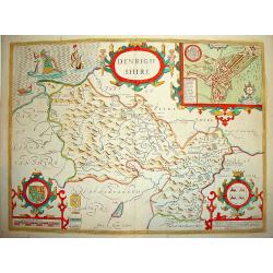
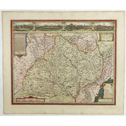
Denbighshire.
Highly decorative map of the county of Denbighshire, located in the northwest corner of Wales. The upper right corner inset contains a plan of the town of Denbigh, along ...
Date: London 1713
Selling price: ????
Please login to see price!
Sold
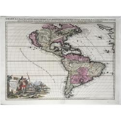
L'Amérique selon les nouvelles..
Rare. Van der Aa's lavish engraving makes his maps among the most prized of the early eighteenth century. This is one of the most attractive and superbly engraved of all ...
Date: Leiden 1713
Selling price: ????
Please login to see price!
Sold
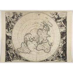
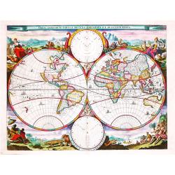
Planisphere Terrestre, Suivant les nouvelles Observations des Astronomes.
Beyond its sheer beauty, this North Polar projection or azimuthal, equidistant world map represents an important step in the history of mapping. Karpinski considers it's ...
Date: Leiden, 1713
Selling price: ????
Please login to see price!
Sold in 2018
L'Etat de L'Eglise..
Although not renowned for the originality of his work, Pieter van der Aa is highly thought of for the design and quality of his output. Showing central part of Italy. Its...
Date: Amsterdam 1713
Selling price: ????
Please login to see price!
Sold
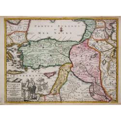
Turquie en Asie.
Pieter van der Aa was a prolific publisher. He published a.o. ' Naauwkeurge versameling der gedenkwaardigste zee- en land-reysen', a series of accounts of voyages (1706-0...
Date: Leiden, 1713
Selling price: ????
Please login to see price!
Sold

Besler Scorsonera Latifolia
Basilius Besler Hortus Eystettensis, published at Eichstatt near Nuremberg in 1613 under the patronage of Johann Conrad von Gemmingen, Bishop of Eichstatt, in whose garde...
Date: Nuremberg 1713
Selling price: ????
Please login to see price!
Sold in 2009

Besler Copper Plate Botanical Engraving
The most impressive of the early seventeenth-century florilegia was the Hortus Eystettensis, published at Eichstatt near Nuremberg in 1613 under the patronage of Johann C...
Date: Nuremberg, 1713
Selling price: ????
Please login to see price!
Sold in 2008
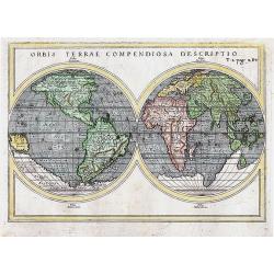
ORBIS TERRAE COMPENDIOSA DESCRIPTIO
Attractive double-hemisphere map of the world based on Mercator\'s monumental map from 1587. It first appeared in Rosaccio\'s 1598 edition of Ptolemy\'s Geographia and wa...
Date: Venice, 1713
Selling price: ????
Please login to see price!
Sold in 2011
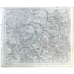
Partie Meridionale de Champagne.
A very detailed map of the Champagne region in France by Guillaume De L'Isle. Major cities such as Provins and Chatillon are included as well as major rivers, lakes and f...
Date: Paris, 1713
Selling price: ????
Please login to see price!
Sold in 2010
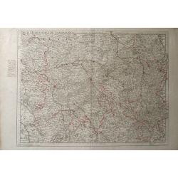
Parte Meridionale de Champagne.
Map of northeastern France centered on the southern Champagne region. The map includes other surrounding regions including Brie, Burgundy, Lorraine and Berry, and numerou...
Date: Paris, 1713
Selling price: ????
Please login to see price!
Sold in 2010
Carte de la Souverainete de Neuchatel et Vallangin.
Map of the Neuchatel region of Switzerland, showing the town of Neuchatel as well as Lake Neuchatel. This finely detailed map shows the shows abbeys and priories, castles...
Date: Paris, 1713
Selling price: ????
Please login to see price!
Sold in 2010
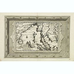
Scheeps-Togt van Malacca na de Golf van Bengale en de kusten van Siam tot in China.
Rare map of the Indian Ocean and Malacca with Singapore (Cingapura) Although not renowned for the originality of his work, Pieter van der Aa is highly thought of for the ...
Date: Leiden, 1713
Selling price: ????
Please login to see price!
Sold in 2011
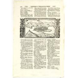
Chersonesus.
Town view of Sevastopol, set in a text page with Latin text. Taken from "Universus Terrarum Orbis", printed in Padua in 1713.
Date: Padua, Lasor a Varea, 1713
Selling price: ????
Please login to see price!
Sold in 2011
![[Title page] Atlas historique tabulae chronologicae. . . Tome I.](/uploads/cache/31599-250x250.jpg)
[Title page] Atlas historique tabulae chronologicae. . . Tome I.
Title page for volume one of the "Atlas historique". Decorative engraved title, with allegorical figures.Henri Abraham Chatelain (1684 – 1743) was a Huguenot ...
Date: Amsterdam, 1713
Selling price: ????
Please login to see price!
Sold in 2011
Le Duche de Lunebourg. . .
A lovely, detailed map by Pierre Van der AA of the northern German region of Luneburg in Lower Saxony, roughly situated between the Elber and the Aller Rivers. Luneburg i...
Date: Leiden, 1713
Selling price: ????
Please login to see price!
Sold in 2021
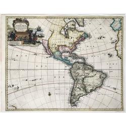
L'Amerique Selon les nouvelles observations de Messrs. de l'Academie des Sciences.
A striking large format map of America, published in Leiden by Pierre van der Aa, in 1713. The map features California as an Island and a projection of the Mississippi pu...
Date: Leiden, 1713
Selling price: ????
Please login to see price!
Sold in 2023
America in Praecipuas Ipsius Partes Distributa ad Observationes. . . 1713.
A large impressive map of the Americas, Western Hemisphere. Full title above: 'America in praecipuas ipsius partes distributa ad observationes Academiae regiae scientiaru...
Date: Leiden, 1713
Selling price: ????
Please login to see price!
Sold in 2020
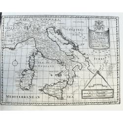
A New Map of Present Italy, together with the Adjoining Islands of Sicily, Sardinia, and Corsica. . .
A scarce copper engraved map of Italy with many places names. A legend key identifies universities. With a large title banner and a distance scale with dividers, dedicate...
Date: Oxford, ca 1701-1714
Selling price: ????
Please login to see price!
Sold in 2020
Nouvelle Carte de L' Amerique.
A decorative early 18th century map with California as an island. Full title and impressum in a cartouche top left: 'Nouvelle Carte de L' Amerique, avec tous ses Royaumes...
Date: Leiden, 1714
Selling price: ????
Please login to see price!
Sold in 2020
Hemisphere Pour Voir Les Terres Meridionale Plus Distinctement Australes.
This beautiful map depicts the explorations and discoveries made by Portuguese, Spanish, Dutch and English explorers in Australia, New Zealand and the South Pacific made ...
Date: Amsterdam, 1714
Selling price: ????
Please login to see price!
Sold in 2021
![[Title page ] Atlas historique, ou nouvelle introduction. . .](/uploads/cache/31636-250x250.jpg)
[Title page ] Atlas historique, ou nouvelle introduction. . .
Letter press with copper engraving. The little engraving (65x85mm.) in the bottom is showing putti looking at maps, a globe, etc. From Chatelain's Atlas Historique. Tittl...
Date: Amsterdam, 1714
Selling price: ????
Please login to see price!
Sold in 2012
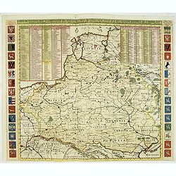
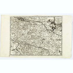
Carte De Pologne Avec La Chronologie Des Rois Et Des Ducs De Lithuanie, Ainsi Que Des Grands Maitres De L'Ordre Teutonique Les Evechez et Archeveches, et Les Armes Des Provinces . . .
Map of Poland with a key table to the towns, and 30 coats of arms on both sides, extending south the Black Sea. Zacharias Chatelain (d.1723) was the father of Henri Abrah...
Date: Amsterdam, ca. 1714
Selling price: ????
Please login to see price!
Sold in 2012
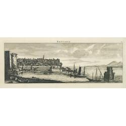
Sattalia.
Beautiful panoramic view of Sattalia. Sattalia was one of the most important cities of the Ottoman Empire and contains many old buildings as can be easily inferred from i...
Date: Paris, 1714
Selling price: ????
Please login to see price!
Sold in 2013
![[No title] La mer noire, autrefois Pont-Euxin. . .](/uploads/cache/32268-250x250.jpg)
[No title] La mer noire, autrefois Pont-Euxin. . .
Map of the Black sea, with the border countries of Turkey (in Asia), Romania, Bulgaria, Moldova, Ukraine and Russia with rivers and coastal towns shown. (Constantinople, ...
Date: Paris, 1714
Selling price: ????
Please login to see price!
Sold in 2020
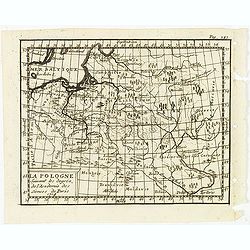
La Pologne suivant les degrés de l'academie des sciences de Paris 1714.
Uncommon miniature map of Poland from one of the editions of the work by Claude Buffier (25 May 1661 – 1737), was a French philosopher, historian & educationalist, ...
Date: Paris, ca. 1714
Selling price: ????
Please login to see price!
Sold in 2012
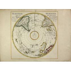
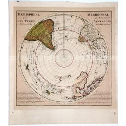
Hemisphere Meridional pour voir plus distinctement les Terres Australes
First edition of the important map of the southern hemisphere by de l'Isle in early strong colors, first published in 1714. This early map of the South Polar regions beca...
Date: Paris, 1714
Selling price: ????
Please login to see price!
Sold in 2013
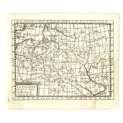
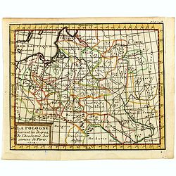
La Pologne suivant les degrés de l'academie des sciences de Paris.
Uncommon miniature map of Poland from one of the editions of the work by Claude Buffier (25 May 1661 – 1737), was a French philosopher, historian & educationalist, ...
Date: Paris, ca. 1714
Selling price: ????
Please login to see price!
Sold in 2015
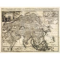
Asia in Praecipuas Ipsius partes distributa ad observationes.
Van der Aa is considered the most accomplished Dutch engraver of his period. He raised the art of map ornamentation to its highest level of sophistication through the use...
Date: Amsterdam, 1714
Selling price: ????
Please login to see price!
Sold in 2016
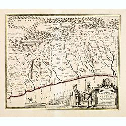
Mingrelie autrefois Colchis, Pays baigné au Couchant par la MER NOIRE. . .
Uncommon and detailed map of the kingdom of Colchis, in the region of Mingrelia, north west Georgia, from Nouvelle atlas, très-exact et fort commode pour toutes sortes d...
Date: Leiden, 1714
Selling price: ????
Please login to see price!
Sold in 2014
La Pologne suivant les degrés de l'academie des sciences de Paris.
Uncommon miniature map of Poland from one of the editions of the work by Claude Buffier (25 May 1661 – 1737), who was a French philosopher, historian and educationalist...
Date: Paris, ca. 1714
Selling price: ????
Please login to see price!
Sold in 2016
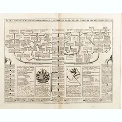
Genealogie de la maison de Wittemberg, ses diferentes branches, ses titres et ses aliances.
Representation of the royal- ducal genealogical tree of the House Wirtemberg with titles, coat of arms and relevants, from volume II of the monumental "Atlas Histori...
Date: Amsterdam, 1714
Selling price: ????
Please login to see price!
Sold in 2014
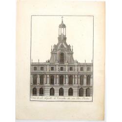
Oeue de la Chapelle de Versailles du Cote du Jardin.
This stunning engraving of the chapel at Versailles is from the work "Les Plans, Profils et Elevations de Versailles" by Giles de Mortain in Paris in 1714. Kin...
Date: Paris, 1714
Selling price: ????
Please login to see price!
Sold in 2018
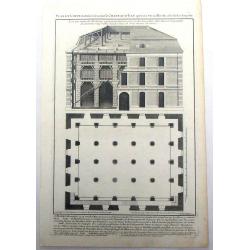
Plan et Coupe du Reservoir Nome le Chateau d'Eau Qui est a Versailles du Cote de la Chapelle.
This stunning engraving featuring the plans for the water house reservoir is from the work "Les Plans, Profils et Elevations de Versailles" by Giles de Mortain,...
Date: Paris, 1714
Selling price: ????
Please login to see price!
Sold in 2017
![[Title page] Atlas historique Tome IV. . .](/uploads/cache/35594-250x250.jpg)
[Title page] Atlas historique Tome IV. . .
Frontispiece from volume IV of the monumental "Atlas Historique" that was published in 1714. Northern Europe is allegorized with sleeping bears, stormy weather,...
Date: Amsterdam, 1714
Selling price: ????
Please login to see price!
Sold in 2015
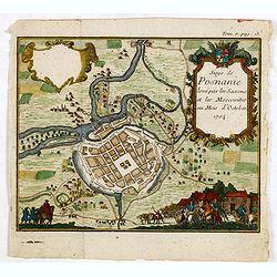
(Poznan) Siege de Posnanie levé par les Saxons & les Moscovites au Mois d'Octobre 1704
Uncommon print of the Battle of Poznan which battle took place on August 9, 1704 in Poznan, Poland during the Great Northern War. The Swedes won the battle.
Date: ca. 1714
Selling price: ????
Please login to see price!
Sold in 2015
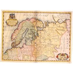
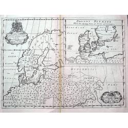
A New Map of Denmark, Norway, Sweden & Moscovy.
A striking decorative map of Skandinavia with Russian Europe added. The cities in Germany and Poland are shown as being part of Sweden and Denmark. Nova Zembla is shown a...
Date: London, 1714
Selling price: ????
Please login to see price!
Sold in 2015
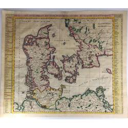
Nouvelle Carte Geographique du Royaume de Dannemarck avec une Table des Villes les Plus Remarquables.
An impressive engraving from Chatelain’s celebrated encyclopedia, “Atlas Historique”. This is a lovely impression of Chatelain’s large map of Denmark. The map cov...
Date: Amsterdam, 1714
Selling price: ????
Please login to see price!
Sold in 2017
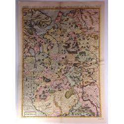
Nouvelle Carte Des Etats Du Grand Duc De Moscovie En Europe.
A detailed map of the Northern and Southern parts of Russia in Europe. A nicely detailed copperplate engraving covering the region from Vibourg in the west, Astracan in t...
Date: Amsterdam, 1714
Selling price: ????
Please login to see price!
Sold in 2018
L'Archeveche de Treves ....
A fine small map of the Archdiocese of Trier in Germany. From Pieter van der Aa’s, “Atlas Nouveau et Des Curieux” published in Leiden in 1714. The cartouche has a c...
Date: Leiden, 1714
Selling price: ????
Please login to see price!
Sold in 2017
Cercle de la Souabe Meridionale ....
A fine small map of the Circle of the Souave. From Pieter van der Aa’s, “Atlas Nouveau Et Des Curieux”, published in Leiden in 1714. This informative map shows the ...
Date: Leiden, 1714
Selling price: ????
Please login to see price!
Sold in 2018
Ducatus Slesvicensis ...
This large, striking, copper engraved map of the Schleswig-Holstein region of Germany names the fortified cities of Flensborg, Tonning, Husum, Sonderborg, and Sleswight. ...
Date: Nuremberg, 1714
Selling price: ????
Please login to see price!
Sold in 2017

Giardino dell N.H. Sig.r Gio. Francesco Morosini in Padova.
A fine large copper engraving of the garden of N.H. Signor Francesco Morosini in Padua. Published in 1714 in Nuremberg, it is by Volckamer from "Nurnbergische Hespe...
Date: Nuremberg, 1714
Selling price: ????
Please login to see price!
Sold in 2016
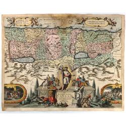
Het Beloofde Landt Canaan Door Wandelt van Onsen Salichmaaker Jesu Christo Nessens Syne Apostelen.
A splendid map of "the beloved land of Canaan," oriented with west at the top of the page, and featuring a multitude of place names as well as St. Paul's sea ro...
Date: Amsterdam, 1714
Selling price: ????
Please login to see price!
Sold in 2016
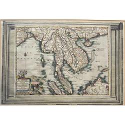
L'Inde De La Le Gange Suivant les Nouvelles Observations...
Fantastic map of South East Asia with today's Malaysia, Thailand, Vietnam Bay of Bengal, Hainan, Straits of Malaca, and the Northern parts of Sumatra and Borneo. Singapor...
Date: Amsterdam, 1714
Selling price: ????
Please login to see price!
Sold in 2016
Orbis Terrarum Tabula Recens Emendata Et In Lucem Edita.
A world map in two hemispheres, decorated in the corners with the representations of the four continents in allegorical form.
Date: Amsterdam / Dordrecht, 1714
Selling price: ????
Please login to see price!
Sold in 2021
LUMEN HISTORIARUM per OCCIDENTEM.
A copperplate hand colored map showing the west Mediterranean.
Date: Amsterdam, ca. 1714
Selling price: ????
Please login to see price!
Sold in 2019
The Loggio in the Bowling Green at Wilton & Front of the Grotto at Wilton.
A fine copper engraving from the first edition of Vitruvius Britannicus or, the British Architect, containing the Plans, Elevations, and Sections of the most Regular Buil...
Date: London, 1714
Selling price: ????
Please login to see price!
Sold in 2017
![[Design Art] Italian Chandelier No. 39.](/uploads/cache/81274-250x250.jpg)
[Design Art] Italian Chandelier No. 39.
A fine copperplate of an Italian Chandelier from the finest 18th-century collection of secular and ecclesiastical designs for silversmiths and goldsmiths by Giovanni Giar...
Date: Prague, 1714
Selling price: ????
Please login to see price!
Sold in 2018
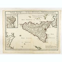
Siciliae Antiquae quae et Sicania et Trinacria dicta tabula geographica.
Map of the ancient Sicily published by Delsile with the imprint 'sur le Quai de l’Horloge cum Privilegio Apr. 1714". Shows forests, a smoking Mount Etna, etc. Cove...
Date: Paris, 1714
Selling price: ????
Please login to see price!
Sold in 2022
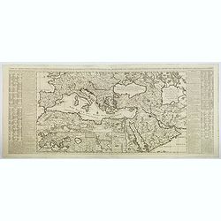
Carte de L'Empire Othoman Consideree dans les Etats de Cette Puissance. . .
This lovely, large map shows the extent of the Ottoman Empire, complete with comparisons to the earlier Empires of Alexander the Great and the Romans. It covers the Medit...
Date: Amsterdam, 1714
Selling price: ????
Please login to see price!
Sold in 2020
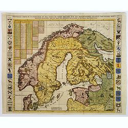
Nouvelle Carte de Scandinavie ou des Etats du Nord dressee sur les Observations. . .
Henri Chatelain's large format decorative map of Scandinavia featuring no less than 34 provincial heraldic shields, 17 on each flank of the map, together with tables of t...
Date: Amsterdam, ca 1714
Selling price: ????
Please login to see price!
Sold in 2018
A New Map of Ancient Scandinavia. . .
A scarce map extending from northern Germany until Russia with old place names. Including Scandinavia and the Baltic. An inset map shows Denmark and southern Sweden in mo...
Date: Oxford, ca 1701-1714
Selling price: ????
Please login to see price!
Sold in 2018
Orbis Terrarum Tabula Recens Emendata et in Lucem Edita.
Beautiful double hemisphere world map from a folio Dutch Bible published by Pieter Keur and Pieter Rotterdam and Pieter Rotterdam de Jonge.Surrounded by fabulous scenes f...
Date: Amsterdam, 1714
Selling price: ????
Please login to see price!
Sold in 2019
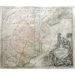
Virginia Marylandia et Carolina in America Septentrionali Britannorum industria excultae. . .
Homann's important map intended to attract German emigration to America. It extends from New York City and Long Island south until present day Georgia, and as far west as...
Date: Nuremberg, ca 1714
Selling price: ????
Please login to see price!
Sold in 2019

Title page : Nouvel Atlas
Uncommon and detailed title page. From "Nouvelle atlas, trés-exact et fort commode pour toutes sortes de personnes, contenant les principales cartes géographiques....
Date: Leiden, 1714
Selling price: ????
Please login to see price!
Sold

Anatomical print. TAB. XX.
Decorative and rare full-page anatomical copperplate engraving by Giulio de' Musi after a drawing by Eustachius and Pier Matteo Pini. From Tabulae anatomicae. In 1552 wit...
Date: Rome, Francesco Gonzaga, 1714
Selling price: ????
Please login to see price!
Sold in 2013

Anatomical print.
Decorative and rare full-page anatomical copperplate engraving by Giulio de' Musi after a drawing by Eustachius and Pier Matteo Pini. From Tabulae anatomicae. In 1552 wit...
Date: Rome, Francesco Gonzaga, 1714
Selling price: ????
Please login to see price!
Sold in 2014
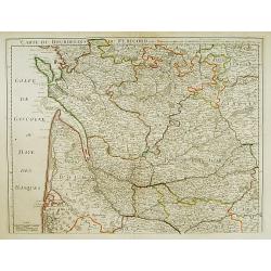
Carte du Bourdelois du Perigord et des provinces voisines..
Map covering the area from La Rochelle till the surrounding country of Bordeaux to the south and till Limoges and Cahors to the east.
Date: Paris 1714
Selling price: ????
Please login to see price!
Sold

Anatomical print.
Decorative and rare full-page anatomical copperplate engraving by Giulio de' Musi after a drawing by Eustachius and Pier Matteo Pini. From Tabulae anatomicae. In 1552 wit...
Date: Rome, Francesco Gonzaga, 1714
Selling price: ????
Please login to see price!
Sold in 2014