Browse Listings
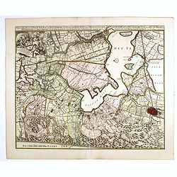
Nieuwe Kaerte van t'Baljuwschap van Kennemerland met de Bannen van Westsaanen, Assendelft, Heemskerk . . .
Rare map prepared by Elisabeth Visscher who was the widow of Nicolas Visscher and republished by Petrus Schenk. East to the top. Including Haarlem, Heemskerk, Velsen, etc...
Date: Amsterdam, 1715
Selling price: ????
Please login to see price!
Sold in 2017
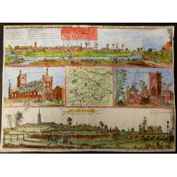
The prospects of the two most remarkable towns in the north of England for the clothing trade, viz. Leeds, As it appears from Holbeck Road, and Wakefield, As it appears from London Road.
This plate was published in Ducatus Leodiensis, or the Topography of the Town and Parish of Leedesby the Yorkshire antiquary Ralph Thoresby.Thoresby continued his father�...
Date: London, 1715
Selling price: ????
Please login to see price!
Sold in 2017
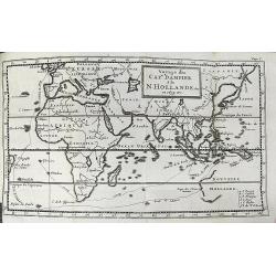
Voyage du Cap.e Dampier, A la N.Hollande &c en 1699 &c.
Uncommon map of the route of Captain William Dampier on the HMS Roebuck. He sailed to Australia, Timor, New Guinea, and discovered New Britain. Australia is shown with un...
Date: Rouen, 1715
Selling price: ????
Please login to see price!
Sold in 2017
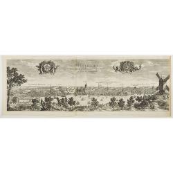
Stockholmia metropolis regni Sueciae et sedes regia qua parte . . .
Very decorative etching of Stockholm by the Parian master engraver and etcher Perelle (1638 - 1695). The title between two elegant cartouches decorated with cherubs, the ...
Date: Paris, 1715
Selling price: ????
Please login to see price!
Sold in 2018
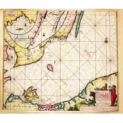
Paskaart Voor een gedeelte van de Oost-Zee. Beginnende van Valsterborn tot Schenkkenes.
A sea chart of the southwest part of the Baltic with two insets showing the coast between Kristianstad and Calmer, and the ports of 'Selfborgh, Boetekolen Rottenbuy'....
Date: Amsterdam, 1715
Selling price: ????
Please login to see price!
Sold in 2021
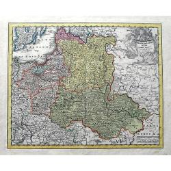
Poloniae & Lithuania accurante curatius.
A very scarce map of Poland, Lithuania, and a large part of Latvia. The copper engraved map extends from the Baltic Sea until Hungary and the southern Ukraine. Published ...
Date: Nuremberg, ca 1715
Selling price: ????
Please login to see price!
Sold in 2019
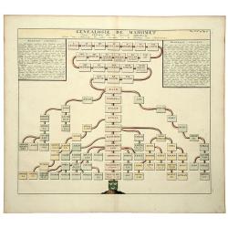
GENEALOGIE DE MAHOMET Depuis Ismael fils du Patriarche Abraham. (Muhammad).
An old colored folio sheet that shows a detailed genealogical chart of Ishmael and his descendants to the prophet Mahomet (Muhammad), founder of Islam. It was published i...
Date: Amsterdam, ca 1715
Selling price: ????
Please login to see price!
Sold in 2020
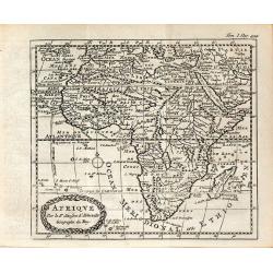
AFRIQVE Par le Sr. Sanson d'Abbeville Geographe du Roy
This map is often confused with the Nicolas Sanson map of Africa of 1656 (Betz #86). In Paris in 1716, a copy of the Sanson map appeared in Methode Pour Etudier La Geogr...
Date: Paris, ca 1716
Selling price: ????
Please login to see price!
Sold in 2013
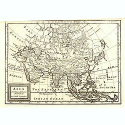
Asia according ti ye Newest Obervations.
Detailed map of Asia, from Herman Moll's "Forty-two new maps of Asia, Africa, and America ... : all engrav’d, according to the latest observations. . ."The ma...
Date: London, J. Nicholson, 1716
Selling price: ????
Please login to see price!
Sold in 2015
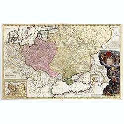
To His Most Serene and August Majesty Peter Alexovitz Absolute Lord of Russia &c. This map of Moscovy, Poland, Little Tartary, and ye Black Sea &c. is most Humbly Dedicated by H. Moll Geographer
Magnificent large-scale, English map of Russia, Ukraine, Poland, Finland and the Baltic Countries and extending south to the Black Sea and the Balkans, with an ornate ded...
Date: London, 1716
Selling price: ????
Please login to see price!
Sold in 2015
Orbis Bibliis Sacris Cognitus Seu Geographia Sacra: Carte de la Geographie Sacree pour l'Ancien Testament.
Interesting copperplate map of the ancient world, showing the biblical lands divided amongst the Sons of Noah: Shem, Ham and Japeth. Informative genealogical table to the...
Date: Paris, 1716
Selling price: ????
Please login to see price!
Sold in 2016
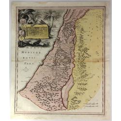
Facies Palaestinae ex Monumentis veteribus descripto ab Hadriano Relando
A striking and historic map showing what is now called Israel, Palestine, Lebanon, Gaza, The West Bank, Jordan, and parts of Syria. The large title cartouche features an ...
Date: Nuremberg, 1716
Selling price: ????
Please login to see price!
Sold in 2016
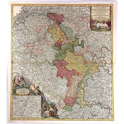
Theatrum Belli Rhenani Auspicatis Militiæ Primitis Potentissimi Roman et Hunga Regis. . .
A detailed and very decorative regional map of the Rhine and Moselle Regions in Germany, exhibiting the Theatre of War in 1702.The inset in the lower left corner traces t...
Date: Nuremberg, 1716
Selling price: ????
Please login to see price!
Sold in 2018
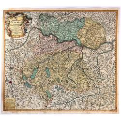
Archiducatus Austriae Superioris.
An antique map of Ober-Österreich between Inn, Donau and Enns, reaching from Passau along the Danube to Ybbs, and south to Salzburg and Rottenmann. After Nicolaas Vissch...
Date: Nuremberg, 1716
Selling price: ????
Please login to see price!
Sold in 2018
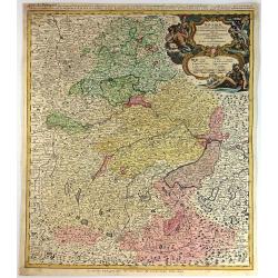
Bavariae Circulus et Electorat in Suasquasque Ditiones...
A striking copper engraved map detailing Bavaria bounded by Nuremberg, Munich, and Passau.The map locates many fortified cities including Munich, Salzberg, Nuremberg, Pas...
Date: Nuremberg, 1716
Selling price: ????
Please login to see price!
Sold in 2016

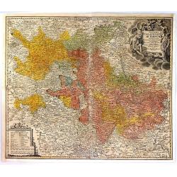
S.R.I. Circulus Rhenanus Inferior sive Electorum Rheni.
A detailed copper engraved map of central Germany that follows the Rhine River from the French border to beyond Dusseldorf. The Moselle River follows the landscape throug...
Date: Nuremberg, 1716
Selling price: ????
Please login to see price!
Sold in 2016
Exactissima Palatinatus Ad Rhenum Tabula, In Qua Episcopus Wormaciensis et Spirensis Ducatus
A fine copperplate map of the Rheinland/Palatinate region of Germany. It displays the area between Cochem on the Mosel, Frankfurt, Marbach, and Saarlouis, the Electorate...
Date: Nuremberg, 1716
Selling price: ????
Please login to see price!
Sold in 2016
Les Provinces des pays-Bas Catholiques. . .
This is an interesting map that can be dated to after the treaty of Utrecht (1712) as this was when Austria was given the Netherlands, and they are designated the 'Austri...
Date: London, ca 1716
Selling price: ????
Please login to see price!
Sold in 2017
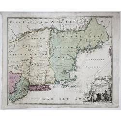
NOVA ANGLIA Septentrionali Americae impantata Anglorumique coloniis florentissima. Geographice exhibita a Ioh. Baptista Homann...
An early map of the Northeast North America, extending north to include Maine and the St. Lawrence and south to include virtually all of New Jersey.In the early 18th cent...
Date: Nurmberg, 1716
Selling price: ????
Please login to see price!
Sold in 2017
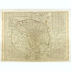
Plan de la Ville et Fauxbourgs de Paris.
A detailed plan of the city and surrounding suburbs of Paris, published "A Paris chez l’Auteur sur le Quai de l’Or.loge avec Pr.r Juin 1716" .The plan has i...
Date: Paris, 1716
Selling price: ????
Please login to see price!
Sold in 2022
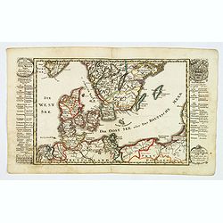
Der Nordischen Konigreiche Sud-West Theil.
An attractive map of the southwest portion of the Nordic kingdom, showing southern Sweden and Denmark, a tiny tip of southern Norway, plus some of the northern German and...
Date: Augsberg, 1716
Selling price: ????
Please login to see price!
Sold in 2021
Das Stifft Naumburg und Zeitz nebst einem grossen Theil der angraenzenden Laender. Verfertiget und in Kupffer gestochen von Johann George Schreibern.
Exceptionally rare, early cartographic work of the Leipzig engraver and Atlas publisher Johann Georg Schreiber (1676-1750), who created only two large-portfolio cards in ...
Date: Leipzig, ca. 1716
Selling price: ????
Please login to see price!
Sold in 2020
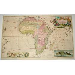
To the right...This Map of Africa.
A superb, beautifully engraved large-scale map of Africa, including 4 insets of ports, coast lines and estuaries across the continent.The work is highlighted by a magnifi...
Date: London, 1716
Selling price: ????
Please login to see price!
Sold
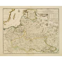
Les Etats de la couronne de Pologne..
Rare map of Poland. In upper right corner a title cartouche, key with longitudes and latitudes to the important cities and coats of arms of Poland, Lithuania, Prussia, Cu...
Date: Paris 1716
Selling price: ????
Please login to see price!
Sold
Generalis Totius Imperii Russorum Novissim Tabula
Map of the Russian Empire. With beautiful cartouche, ships and seamonsters.
Date: Nuremberg, 1716
Selling price: ????
Please login to see price!
Sold in 2008
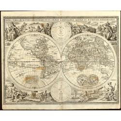
Orbis Terrarum Typus de Integro in Plurimis Emendatus Auctus et Icunculis Illustratus
Outstanding and rare example of a bible world map based on the Visscher bible map from 1657 (Shirley 401/414). This map is larger in size and has an extra engraved frame ...
Date: Minden, 1716
Selling price: ????
Please login to see price!
Sold in 2008
Viertzig Iõhrige Reysen der Kinder Israel aus Egypten durch das Rothe Meer und W³sten bis ins Gelobte Land Canaan
Rare anonymous map of the Holy Land after the N. Visscher map from 1657. Showing the Exodus of the Israel tribes from Egypt to Canaan. With beautiful figural cartouche an...
Date: Minden, 1716
Selling price: ????
Please login to see price!
Sold in 2008
Die Gelegenheit des Paradeis und des Landes Canaan, sambt den erst Bewohnten Lõnderen der Patriarchen aus H. Schrift u anderen Auctoren zusamen getragen
Very rare anonymous map of the Middle East. Based on the "Paradise Map" of Visscher. Showing the Eastern Mediterranean with Cyprus up to today Iraq / Iran in th...
Date: Minden, 1716
Selling price: ????
Please login to see price!
Sold in 2009
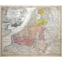
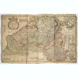
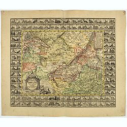
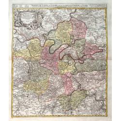
Tabula Generalis Totius Belgii qua Provincia XVII Infer Germania olim fub S.R.I. Circulo Burgundia . . .
Decorative map by Johann Baptist Homann which shows the entire region of The Netherlands and Belgium with its seventeen provinces. A decorative title cartouche is in the ...
Date: Nuremberg, 1716
Selling price: ????
Please login to see price!
Sold in 2010
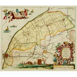
Carte d'Artois et des Environs ou lon voit le Ressort du Conseil Provincial d'Artois.
Finely detailed map of the Artois region of northern France bordering Belgium, showing the cities of Douai, Arras and Lille. Once a state of the Holy Roman Empire, Artois...
Date: Paris, 1716
Selling price: ????
Please login to see price!
Sold in 2010
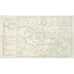
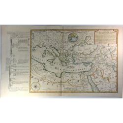
Carte de la Geographie sacrée pour l'ancien testament. . .
Beautiful map of the coast of the Mediterranean, including the south of France, Italy, the north African coast, and the near east. On the left, there is a "Table mé...
Date: Paris, 1716
Selling price: ????
Please login to see price!
Sold in 2012
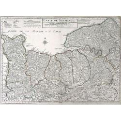
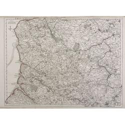
Carte de Normandie ousont marquez exacteme Les Pays ou Contrees enferm ees dascette Province aussi bien que les Villes Bourgs Paroissese.
Finely detailed map of the Normandy region of France by Guillaume de L'Isle. Shows the coastline along the English channel, along with the towns and villages, forests, ab...
Date: Paris, 1716
Selling price: ????
Please login to see price!
Sold in 2010
Agri Parisiensis. . .
A detailed map of Île-de-France centered on Paris. Paris is still quite small - Montmartre, Les Invalides, and others are shown as small separate villages. Extends until...
Date: Nuremberg, ca 1716
Selling price: ????
Please login to see price!
Sold in 2019
La Sphere Artificielle ou Armilaire Oblique. . .
A large copper engraving with an armillary sphere in the centre, with the faces of the horizon, meridian and the celestial equator represented by fixed circles. In this e...
Date: Paris, 1716
Selling price: ????
Please login to see price!
Sold in 2020
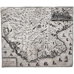
Regni Norvegiæ Nova et Accurata descriptio.
A very rare, decorative map of Norway with inset battle scene and many ships sailing along the coast. The map was included in the fall 1716 issue of Relationis Historicæ...
Date: Frankfurt, 1716
Selling price: ????
Please login to see price!
Sold in 2020
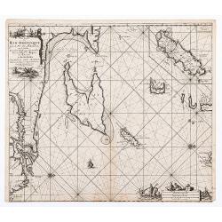
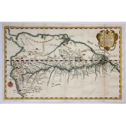
Pas kaart Van Rio Oronoque Golfo de Paria met d'Eylanden Trinidad, Tabago, Granada, Granadillos, en Bequia ...
Double page chart of the mouth of the Orinoco and the adjacent Venezuelan coastline orientated with north to the right edge. The islands of Trinidad, Tobago and Grenada s...
Date: Amsterdam, Gerard van Keulen 1717
Selling price: ????
Please login to see price!
Sold in 2020
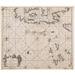
Pas Kaart Van de Noord Kust van Espaniola met d'Eylanden door Benoorden
Double page chart showing the north coast of Hispaniola with the adjacent islands of the Turks and Caicos. Inset charts of the island of Tortue and the bay of Gonaives. T...
Date: Amsterdam: [Gerard van Keulen 1717
Selling price: ????
Please login to see price!
Sold in 2020
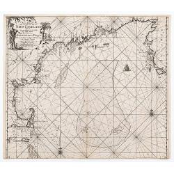
Pas - Kaart Vande Zee Kusten inde Boght van Niew Engeland tusschen de Staaten Hoek en C. de Sable ...
Double page chart of the coastline and waters of New England from Cape Cod through to southern Nova Scotia. The chart with rhumb lines, compass roses and a ship illustrat...
Date: Amsterdam, Gerard van Keulen 1717
Selling price: ????
Please login to see price!
Sold in 2020
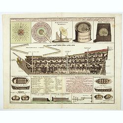
Durchschnitt eines Capital Krieg-Schiffs. . .
A superb engraving of marine architecture featuring a three-masted 96 gun man-o-war. The rendering provides great detail of the ship's equipment, construction, rigging, e...
Date: Nuremberg, 1717
Selling price: ????
Please login to see price!
Sold in 2021
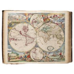
Atlas
An important and rare atlas by the Danckerts family: containing 86 maps and double plates, most in color, titled in Latin, sometimes in Dutch or French: With an allegoric...
Date: Amsterdam, ca.1712-1717
Selling price: ????
Please login to see price!
Sold in 2025
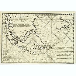
Carte réduite de l'extrémité de l'Amérique méridionale dans la partie du Sud . . .
Map of the southern extremities prepared by the French military engineer, mathematician, spy, and explorer Amédée-François Frezier (1682-1773).He is best remembered fo...
Date: Amsterdam, Pierre Humbert, 1717
Selling price: ????
Please login to see price!
Sold in 2012
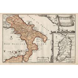
Le Royaume de Naples.
Map of the southern part of Italy, with an inset picturing Sardinia.From De Fer's Atlas Curieux.
Date: Paris, 1705-1717
Selling price: ????
Please login to see price!
Sold in 2012
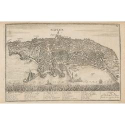
Naples.
Map of the city of Naples.From De Fer's Atlas Curieux.
Date: Paris, 1705-1717
Selling price: ????
Please login to see price!
Sold in 2012
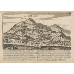
Le Mont Cassin ...
Engraving of Monte Cassino, near the town of Cassino between Rome and Naples.From De Fer's Atlas Curieux.
Date: Paris, 1705-1717
Selling price: ????
Please login to see price!
Sold in 2014
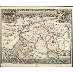
Syriae Sive Soriae Nova et Accurata Desctiptio.
Striking copper engraved map of Syria and Lebanon with a slice of Turkey, including Cyprus. Embellished with decorative, figured title and scale cartouches including four...
Date: 1717
Selling price: ????
Please login to see price!
Sold in 2014
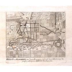
Hulst in Flandern von Denen Franzosen, 1702.
Fine copper engraving of the Hulst Fortress by Merian from "THEATRUM EUROPAEUM" in 1717.
Date: Frankfurt am Main, 1717
Selling price: ????
Please login to see price!
Sold in 2015
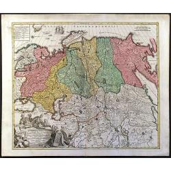
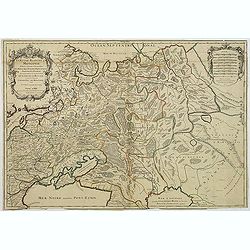
La Russie Blanche ou Moscovie Divisee Suivant l'Estendue Des Royaumes Duches. . .
European Russia, including Ukraine. With ornamental title cartouche and scale cartouche in the upper corners. Russia, extending from the Baltic and Black Seas to Grande T...
Date: Paris, ca. 1685 - 1717
Selling price: ????
Please login to see price!
Sold in 2016
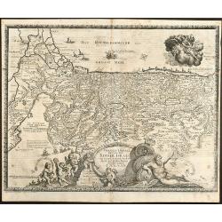
Nova et accurata Tabula sedis belli in Regno Hungariae. Accendunt cetera Regna Sclavonia, Croatia, Bosnia, Servia, Dalmatia, Bulgaria et Romania . . .
Wall map in 4 separate sheets, if joined 915 x 1118mm. Map of Hungary, with Transylvania, Croatia, Poland and Slovenia after Conte Luigi Marsigli (1658-1730, an Italian m...
Date: Amsterdam, 1717
Selling price: ????
Please login to see price!
Sold in 2016
Tabula Geographica Terrae Sanctae, Auctore J. Bonfrerio Societat Jesu.
Uncommon map of Holy Land showing the wandering of the Children Israel's with the 42 encampments, published by Francois Halma. Oriented with north at top left and divided...
Date: Amsterdam, F.Halma, 1717
Selling price: ????
Please login to see price!
Sold in 2018
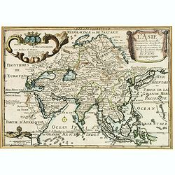
L'Asie Suivant les Nouvelles Decouvertes. . .
Showing the land masses from Arabia to Japon ou I.de Niphon and Nouvelle Zeelande (but what is part of New Guinea). Decorative dedication panel and title cartouche.
Date: Paris, 1717
Selling price: ????
Please login to see price!
Sold in 2016
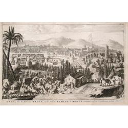
Rama van d'Arabieren Ramla, en de Turken Remele, en Remle genaamt; volgens d'aftekening gedaan 1668.
Interesting view of the city of Ramallah in Israel. Shows a water place in the foreground, with numerous animals drinking. The city in the background is very detailed wit...
Date: Leeuwarden, 1717
Selling price: ????
Please login to see price!
Sold in 2016
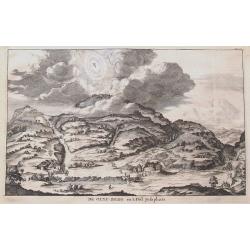
De Olyf-Berg en 't Dal Josaphats.
Shows the Mount of Olives and the Valley of Josaphat with Jesus ascending to heaven.
Date: Leeuwarden, 1717
Selling price: ????
Please login to see price!
Sold in 2016
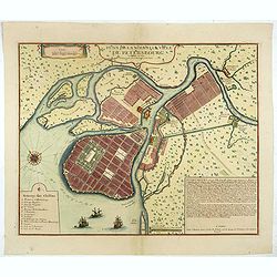
Plan De La Nouvelle Ville De Petersbourg.
The first printed city plan of St. Petersburg, created not long after the founding of the City by Czar Peter the Great. Shows St. Petersburg as it was planned to be built...
Date: Paris, 1717
Selling price: ????
Please login to see price!
Sold in 2019
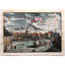
Prospect Dom Obern Thor Zu Altdorff.
Fine city view of Altdorff Bei Nurnberg, Germany by Johann Puschner in 1717. The view features the protected entrance to the city with a carriage and horses entering. It ...
Date: Nurnberg, 1717
Selling price: ????
Please login to see price!
Sold in 2017
Bellogradum VI Capitur.
An extremely rare, large view of Belgrade. Just one copy found (in the Bayerische Staatsbibliotek, Munich, Germany). It seems to be made of two copper plates, the lower o...
Date: Augsburg / Amsterdam, 1717
Selling price: ????
Please login to see price!
Sold in 2017
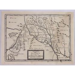
Syria and Assyria According to the Description of Ptolomy and Other Authors.
A map of Syria and Assyria according to Claudius Ptolemy and other authors, by Herman Moll from the “Geographica Classica” published in London in 1717. It features na...
Date: London, 1717
Selling price: ????
Please login to see price!
Sold in 2019
Cours du Fleuve Maragon Autrement du de Amazones. . .
This was the first close to correct chart of the Maranon territory. The map shows all of northern South America, and locates Lima and Cusco. With a decorative title carto...
Date: London, 1717
Selling price: ????
Please login to see price!
Sold in 2018
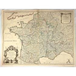
Le Royaume de France Dresse les Memoires et Nouvelles Observations de Messieurs de l'Academie Royalle de Sciences
Very large, copper engraved map of France. It was published by the Jaillot family in Paris in 1717. The map features a large title cartouche with a coat of arms surround...
Date: Paris , 1717
Selling price: ????
Please login to see price!
Sold in 2018
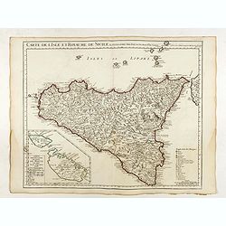
Carte de l'Isle et Royaume de Sicile . . .
Detailed map of Sicily. Inset map of Malta :"Carte particulière de l'Ile de Malte". With the address : Chez l’Auteur sur le Quai de l’Horloge avec Privileg...
Date: Paris, 1717
Selling price: ????
Please login to see price!
Sold in 2022
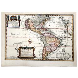
L' AMERIQUE MERIDIONALE ET SEPTENTRIONALE.
A striking example of N. De Fer's desirable map of the Americas. In North America, California is shown as an Island with coastal names. An early Great Lakes configuration...
Date: Paris, 1717
Selling price: ????
Please login to see price!
Sold in 2019
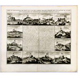
Vue et description des Forts Que Les Hollandois, Anglois, et Danois ont sur la cote de Guinee.
Decorative, copperplate sheet with 12 vies of African Cities, from Chatelain's monumental 7 volume Atlas Historique.Includes a series of views showing Map shows on 12 vie...
Date: Paris 1717
Selling price: ????
Please login to see price!
Sold in 2019
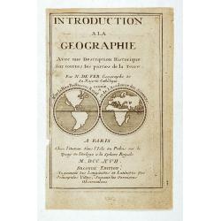
Title page: Introduction a la Geographie..
A title page from "Introduction a la Geographie", with in center a double hemisphere world map, each approx. 3.7cm diameter. California as a large island with i...
Date: Paris 1717
Selling price: ????
Please login to see price!
Sold
L'Afrique Dressée selon les derniners relat et suivant les nouvelles decouvertes...?
Striking copper plate engraved map of all of Africa from the 'Atlas Curieux' of Nicholas de Fer (1646-1720). Tooley p.45, plate 33, third state with the date 1717. Curiou...
Date: Paris, 1717
Selling price: ????
Please login to see price!
Sold
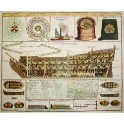
Durchschnitt eines Capital Krieg-Schiffs..
Superb engraving of marine architecture featuring a three-masted 96 gun man-o-war. The rendering provides great detail of the ship's equipment, construction, rigging, etc...
Date: Nuremberg 1717
Selling price: ????
Please login to see price!
Sold
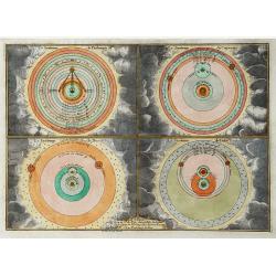
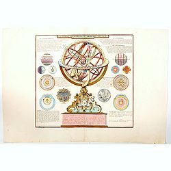
"Le Systeme de Ptolomée.. / de Copernic. / de Descartes. / Ticho Brahe."
Four decorative print on one sheet showing the systems of Ptolemy, Copernicus, Descartes and Brahe. Engraved by H. van Loon..
Date: Paris 1717
Selling price: ????
Please login to see price!
Sold
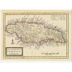
A New Map of the Island of Jamaica.
Finely engraved map of Jamaica showing towns, churches, sugar works, cotton works, indico works and cacao works. Rich nomenclature illustrating the coast.Adorned with a c...
Date: London 1717
Selling price: ????
Please login to see price!
Sold
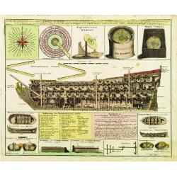
Durchschnitt eines Capital Krieg-Schiffs..
Superb engraving of marine architecture featuring a three-masted 96 gun man-o-war. The rendering provides great detail of the ship's equipment, construction, rigging, etc...
Date: Nuremberg 1717
Selling price: ????
Please login to see price!
Sold
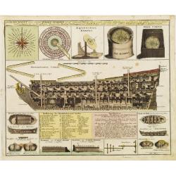
Durchschnitt eines Capital Krieg-Schiffs..
Superb engraving of marine architecture featuring a three-masted 96 gun man-o-war. The rendering provides great detail of the ship's equipment, construction, rigging, etc...
Date: Nuremberg 1717
Selling price: ????
Please login to see price!
Sold
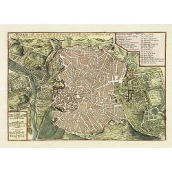
Madrid, ville Considerable de la Nouvelle Castille. . .
Plan of Madrid engraved by C Inselin, stretching from Westminster Abbey in the west to Mile End in the east. A 26 point key identifies important landmarks.From De Fer's &...
Date: Paris, 1717
Selling price: ????
Please login to see price!
Sold in 2011
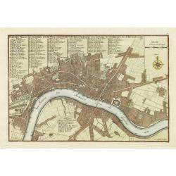
Plan des villes de Londres et de Westminster et de leurs Faubourgs avec le bourg de Southwark. . .
Plan of London engraved by C Inselin, stretching from Westminster Abbey in the west to Mile End in the east. A 113 point key identifies important landmarks.This is the ra...
Date: Paris, 1717
Selling price: ????
Please login to see price!
Sold in 2011
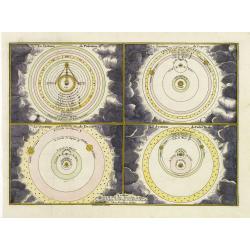
Le Systeme de Ptolomée.. / de Copernic. / de Descartes. / Ticho Brahe.
Four decorative print on one sheet showing the systems of Ptolemy, Copernicus, Descartes and Brahe. Engraved by H. van Loon..
Date: Paris, 1717
Selling price: ????
Please login to see price!
Sold in 2011
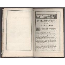
Introduction a la Geographie..
Second edition of this charming travel compendium. The title page illustrated with miniature world map in double hemisphere showing California as an island, with imprint ...
Date: Paris, 1717
Selling price: ????
Please login to see price!
Sold in 2008
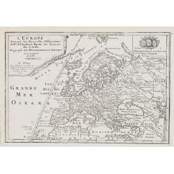
L'Europe, Suivant les Nouvelles Observations de M.rs de L'Academie Royale des Siences. . .
The map was published by N. de Fer (1646-1720), Geographe du Roy, and shows in great evidence the Meridian Line choose by French cartographers in 1634 as framework for th...
Date: Paris, 1717
Selling price: ????
Please login to see price!
Sold in 2018
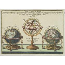
La Sphere Artificielle. . .
A decorative print of a set of table globes consisting of a celestial globe, armillary sphere and a terrestrial globe.
Date: Paris, 1717
Selling price: ????
Please login to see price!
Sold in 2010
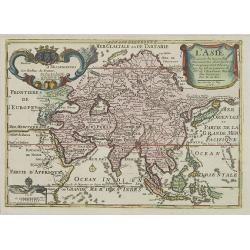
L\'Asie Suivant les Nouvelles Decouvertes. . .
Showing the land masses from Arabia to Japon ou I.de Niphon and Nouvelle Zeelande (but what is part of New Guinea). Decorative dedication panel and title cartouche.
Date: Paris, 1717
Selling price: ????
Please login to see price!
Sold in 2009
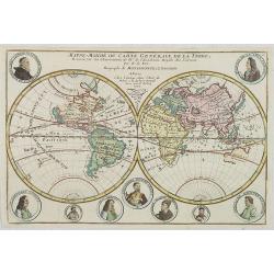
Mappe-Monde ou Carte Generale de la Terre..
Nice double hemisphere world map surrounded by medallion portraits of important explorers, including Columbus, La Salle, Magellan, Drake, Père Tachard, Dampier, Vespucci...
Date: Paris, 1717
Selling price: ????
Please login to see price!
Sold in 2012
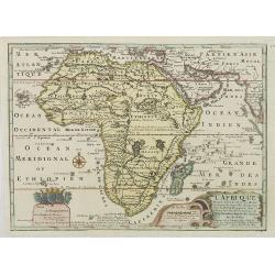
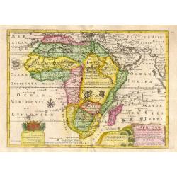
L'Afrique Dressée selon les dernieres relat. et suivant . . .
Map of Africa. Decorative dedication panel and title cartouche.
Date: Paris, 1717
Selling price: ????
Please login to see price!
Sold in 2009
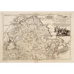
La Gran Tartaria descritta secondo le relationi ..
Prepared by De Fer. Including Korea and Japan. A peninsula protrudes out of Tartary and is called Yupi and is separated from Honshu by the Strait of Zungar (Tsugaru). Rar...
Date: Napels, 1717
Selling price: ????
Please login to see price!
Sold
La Russie Blanche ou Moscovie divisée. . .
Fine map of the European part of Russia with a decorative title and scale cartouche.Alexis-Hubert Jaillot (1632-1712), was a French cartographer. He joined the Sanson hei...
Date: Paris, 1717
Selling price: ????
Please login to see price!
Sold in 2011
Frisiae dominium vernaculé Friesland..
Very detailed and decorative map of Friesland. Upper left hand corner inset map of the Frisian islands. Lower left statue of the Steenen Man of Harlingen. Key map from th...
Date: Amsterdam 1718
Selling price: ????
Please login to see price!
Sold