Browse Listings
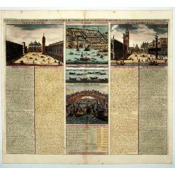
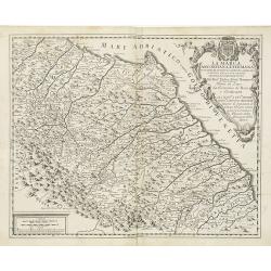
Carte du Gouvernement Civil et Politique de l a Republique de Venise ses Differens Conseils de Palais de St Marc et Celui des procurateurs.
This impressive engraving is a wonderful example of Chatelain's elegant plates. It provides a detailed description of the infrastructure of the Venetian government. Ornam...
Date: Amsterdam, 1710
Selling price: ????
Please login to see price!
Sold in 2020
![[German liberty heroes tree] Trophee Eleve a la Gloire des Premiers Heros de la Liberte Germanique et a celle de leurs decendants.](/uploads/cache/83599-250x250.jpg)
[German liberty heroes tree] Trophee Eleve a la Gloire des Premiers Heros de la Liberte Germanique et a celle de leurs decendants.
An elaborate tree featuring 41 coats of arms and family crests and pictures of the hero's of german history. The base of the tree comes from a large tankard adorned by se...
Date: Paris, 1710
Selling price: ????
Please login to see price!
Sold in 2020
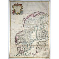
Sweden Corrected from the Observations Communicated to the Royal Society in London and the Royal Academy in Paris. . .
A large-scale general map of Scandinavia. In addition to Sweden, it shows Norway, Denmark and Finland. The new city of St. Petersburg (founded 1703) is shown at the head ...
Date: London, 1710
Selling price: ????
Please login to see price!
Sold in 2020
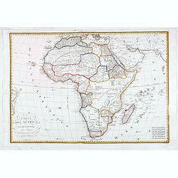
Carta dell Affrica in eisa dalli Fratelli Bordiga.
Decorative map of the African continent with Madagascar and the surrounding islands. Also the Arabia peninsular. Published by the Bordiga brothers of Milan.
Date: Milan, ca. 1710
Selling price: ????
Please login to see price!
Sold in 2020
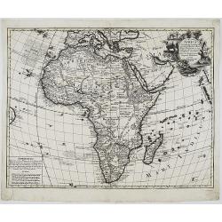
AFRICA Concinnata Secundum Observationes. . .
A rare issue by German the publisher Jeremia Wolff of de l’Isle’s map of Africa, which served as the model for European mapmakers, and was frequently copied throughou...
Date: Augsburg, 1710
Selling price: ????
Please login to see price!
Sold in 2020
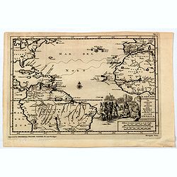
H. Benzos Scheep-togt uit Italie over Spanje na de Westindize Eylanden, en Kusten van't Zuider America.
A delightful map of the Atlantic Ocean highlighting the route of explorer Hieronymus Benzon, who travelled from Spain to the Americas, and back to Italy between 1541-56. ...
Date: Leiden, ca 1710
Selling price: ????
Please login to see price!
Sold in 2020
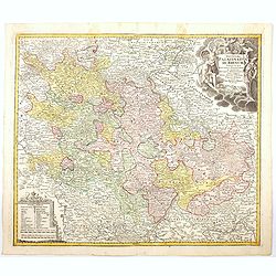
Exactissima Palatinatus ad Rhenum. . .
A nice detailed map covering the southern part of the river Rhine. Including the towns of Frankfurt, Heidelberg, Neustadt, Saarbrucken, Mainz, etc. Embellished with a lov...
Date: Nuremberg, 1710
Selling price: ????
Please login to see price!
Sold in 2020
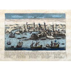
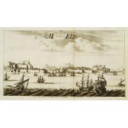
Tripoli.
A decorative view of Tripoli. With detailed sailing ships and buildings. Below the view with descriptive French text of the city and its (pirate) history. A 1-16 legend k...
Date: Paris, ca 1710
Selling price: ????
Please login to see price!
Sold in 2020
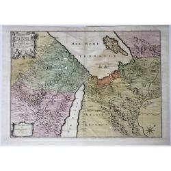
Les Deserts D'Egypte de Thebaide D'Arabie, De Sirie &c.
Full title and impressum in a cartouche top left: 'Les Deserts D'Egypte de Thebaide D'Arabie, De Sirie, &c. ou Sont Exactement Marques Les Lieux Habitez Par Les Sainc...
Date: Amsterdam, 1710
Selling price: ????
Please login to see price!
Sold in 2021
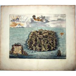
SAINT HELENA.
This fine hand colored original copper-plate engraved antique map of the Island of St Helena in the southern Atlantic, was published by Pieter Van der Aa. With cherubs, s...
Date: Amsterdam, ca 1710
Selling price: ????
Please login to see price!
Sold in 2021
![TRADIDIT MUNDUM DISPUTATIONIBUS EORUM [God has delivered the world to their disputes.]](/uploads/cache/85220-250x250.jpg)
TRADIDIT MUNDUM DISPUTATIONIBUS EORUM [God has delivered the world to their disputes.]
A fine copper engraved allegorical frontispiece to Vol.7 of Scherer's 'Atlas Novus' This print depicts the World inside a celestial sphere, which is hold by Gods hand at...
Date: Munich, 1710
Selling price: ????
Please login to see price!
Sold in 2021
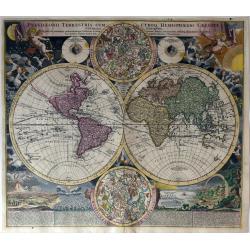
Planiglobii Terrestris Cum Utroq Hemisphaerio Caelesti Generalis Exhibitio..
Intriguing and spectacular world map, one of the most decorative world maps of the eighteenth century. This is the first edition of J.B. Homann's double hemisphere map, w...
Date: Nuremberg, 1710
Selling price: ????
Please login to see price!
Sold in 2021
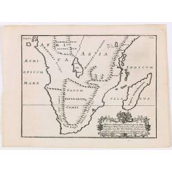
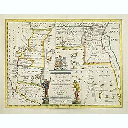
Ultimae Aethiopum utrorumque in Asia Africaque Orae . . .
A uncommon map of South Africa after Pompus Mela, with Madagascar with a large cartouche lower left with dedication to Ric. Elsworth of Bickham.From "De situ orbis l...
Date: London, Philipp Bishop, 1711
Selling price: ????
Please login to see price!
Sold in 2020
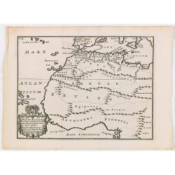
Africae fons illa, quae Mari Atlantico . . .
A uncommon map of West Africa with a large dedicational cartouche lower left corner.From "De situ orbis libri tres, ad omnium Angliae & Hiberniae codicum mss. fi...
Date: London, 1711
Selling price: ????
Please login to see price!
Sold in 2020
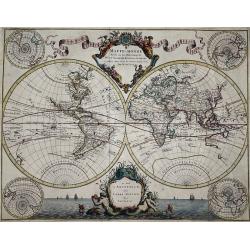
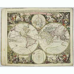
Mappe-Monde Dresse sur les Observations de Mrs. de l'Academie Royale des Sciences. . .
World map by M. de L'Isle, published by Pierre Mortier 1705-1711. A double hemisphere world map with four polar views showing the world from various angles in the corners...
Date: Amsterdam, 1705-1711
Selling price: ????
Please login to see price!
Sold in 2021
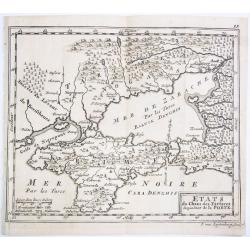
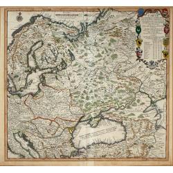
ETATS du Cham des Tartares dependent de la Porte.
A rare copper engraved map of the southern Ukraine and the Crimea peninsula. From 'Theatre complete et particularise de la Guerre du Nort', La Haye ,1711.
Date: La Haye, 1711
Selling price: ????
Please login to see price!
Sold in 2021
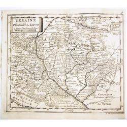
UKRAINE ou Palatinat de Kiowie.
A rare copper engraved map of the central Ukraine and the Kiev surrounding. From 'Theatre complet et particularise de la Guerre du Nort', La Haye ,1711.
Date: La Haye, 1711
Selling price: ????
Please login to see price!
Sold in 2021
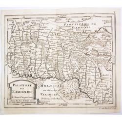
PALATINAT DE KAMIENIEC.
A rare copper engraved map of the former Polish Palatinate of Kamieniec in the south-western Ukraine. From 'Theatre complet et particularise de la Guerre du Nort', La Hay...
Date: La Haye, 1711
Selling price: ????
Please login to see price!
Sold in 2021
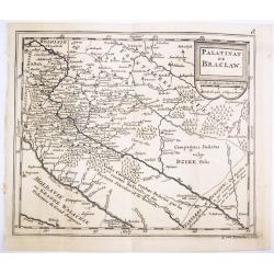
PALATINAT DE BRACLAW.
A rare copper engraved map of the old Polish Palatinate of Braclaw in the south-western Ukraine. From 'Theatre complet et particularise de la Guerre du Nort', La Haye , 1...
Date: La Haye, 1711
Selling price: ????
Please login to see price!
Sold in 2021
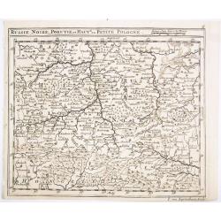
RUSSIE NOIRE, POKUTIE,et HAUTE ou PETITE POLOGNE.
A rare copper engraved map of the western Ukraine and southern Poland. From 'Theatre complet et particularise de la Guerre du Nort', La Haye , 1711.
Date: La Haye, 1711
Selling price: ????
Please login to see price!
Sold in 2021
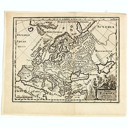
Summa Europae Antique Descriptio.
Striking and decorative map of Europe, with an ornate cartouche. Nice dark impression. From Cluverius' "Introductio in Universam Geographiam" (first issued in 1...
Date: London, 1711
Selling price: ????
Please login to see price!
Sold in 2023
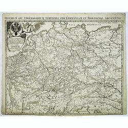
Postarum seu veredariorum stationes per Germaniam et provincias adiacentes
Rare post road mapspost route map of the Low Countries, Germany, Poland, Switzerland and Austria. Including the towns of Venice, Paris, Lübeck, Krakow and centered on Ba...
Date: Brussels, 1711
Selling price: ????
Please login to see price!
Sold in 2012
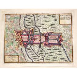
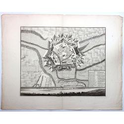
Bouchain: Ville Forte du Comte de Hainaut Situee Sur la Riviere d'Escaut.
Fine little plan of the fortification of Bouchain by Pieter Devel and published by Eugene Henry Fricx. The Siege of Bouchain (August – September 1711), was a siege of ...
Date: Brussels, 1711
Selling price: ????
Please login to see price!
Sold in 2013
Carte Pour l\'Intelligence des Affaires Presente Des Turcs, des Tartares, des Hongrois, des Polonois, des Suedois, et des Moscovites Aux Environs . . .
Scarce Nicolas de Fer map of the region centred on Russia and extending east to the mouth of the Volga in the Caspian Sea, west to the Baltic, South to the Black Sea, Ita...
Date: Paris, 1711
Selling price: ????
Please login to see price!
Sold in 2014
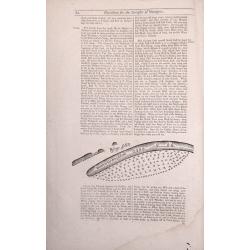
A Description of the Islands of Joanna (Anjouan).
A Description of the Islands of Joanna by Samuel Thornton. Small woodblock chart by Samuel Thornton of The Island of Joanna published in 1711 by John How and Samuel Thorn...
Date: London, 1711
Selling price: ????
Please login to see price!
Sold in 2014
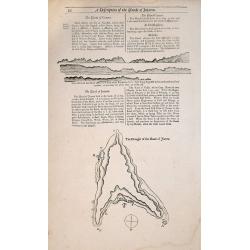
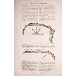
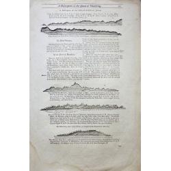
The Tryal Rocks.
Small woodblock chart of The Tryal Rocks from The English Pilot The third Book 1711. Of particular interest to the History of Australia. Australia's Oldest Ship Wreck.Rar...
Date: London, 1711
Selling price: ????
Please login to see price!
Sold in 2014
The Making of the Canary Islands.
The Making of the Canary Islands, a woodblock chart by Samuel Thornton showing the approaching coast lines of The Island of Madera, Gran Canaries and Island of Palma on t...
Date: London, 1711
Selling price: ????
Please login to see price!
Sold in 2014
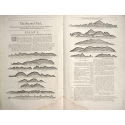
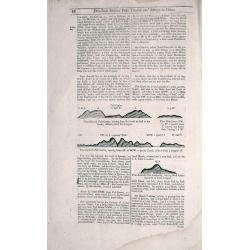
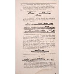
Directions between Amoye and Chusan.
Text page with woodblock plofiles by Samuel Thornton showing the approaching coast lines of The Island of Quesan, Sampanna, Lamjett and Island of Hightan on the verso dir...
Date: London 1711
Selling price: ????
Please login to see price!
Sold in 2014
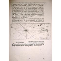
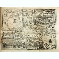
Two double sided pages No's 25 & 26 ‘Directions for the coast of Arabia.' 27 & 28 Directions for the Coast of Persia & ‘Directions for the coast of Arabia
Four woodblock chart’s on two double sided sheets by Samuel Thornton showing the approaching coast lines Arabia by John How and Samuel Thornton. Pages numbered 25,26,27...
Date: London, 1711
Selling price: ????
Please login to see price!
Sold in 2015
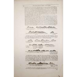
Three double sided pages No's 65 & 66 ‘Directions from the River Siam to the River of Cambodia.' Directions between Pulo Timoan and Amoye in China. 67 & 68 Directions between Pulo Timoan and Amoye in China. 69 & 70,
Six woodblock chart’s on three double sided sheets by Samuel Thornton showing the approaching coast lines China by John How and Samuel Thornton.Published in "The E...
Date: London, 1711
Selling price: ????
Please login to see price!
Sold in 2014
Two double sided pages No's 57 & 58 A Description of the West Coast of Sumatra & The West coast of Sumatra 59 & 60 The West coast of Sumatra & Instructions for Sailing through the Streights of Diron
Four woodblock chart’s on two double sided sheets by Samuel Thornton showing the approaching coast lines of Sumatra. Published in "The English Pilot, the Third Boo...
Date: London 1711
Selling price: ????
Please login to see price!
Sold in 2014
Two double sided pages No's 61 & 62 Directions for the Streights of Singapore. 63 & 64 Directions for the Old Streights of Singapore & Instructions for Sailing from Pulo Tingay to Siam.
Four woodblock chart’s on two double sided sheets by Samuel Thornton showing the approaching coast lines of Singapore & Thailand.Published in "The English Pilo...
Date: London, 1711
Selling price: ????
Please login to see price!
Sold in 2014
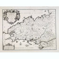
Gouvernement général du Duché de Bretagne, Divisée en Haute et Basse.
First state. Separation in Upper and Lower Brittany as shown on the 1705 plate is now corrected.
Date: Paris, 1711
Selling price: ????
Please login to see price!
Sold in 2015
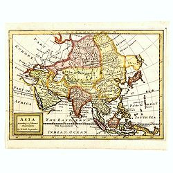
Asia According to ye Newest Observations. . .
Fine map of Asia covering from Asia Minor in the west to New Guinea in the east. It includes South East Asia and New Guinea, but not Australia. From Moll's "Atlas Ge...
Date: London, 1711
Selling price: ????
Please login to see price!
Sold in 2016
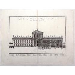
Ausriss des Vorigen Palasts, Wie er Nach dem Garten Zu. (The Palace After the Garden)
This magnificent copper engraving is from Paul Decker's work entitled "Furstliche Baumeister, oder Architectura Civilis.... Published in Augsburg, Germany by Peter D...
Date: Augsburg, 1711
Selling price: ????
Please login to see price!
Sold in 2023
A Description of the Island of Mauritius - Don Mascarenhas Island.
No’s 23 – 24 A woodblock chart on a double sided sheet by Samuel Thornton showing the approaching coast line of Mauritius 23’ on the verso 24’ shows Don Mascarenh...
Date: London 1711
Selling price: ????
Please login to see price!
Sold in 2015

Carte généalogique de la maison de Plantagenette et des ducs Normandie avec les branches, et les alliances quelles, ont formées; pour conduire a l'intelligence de l'histoire d'Angleterre et d'Ecosse et d'Irlande.
A very attractive, hand colored genealogical chart of mediaeval English royal families, including thirteen coats of arms of Edward the Confessor, Edward III, the Plantage...
Date: Paris, 1711
Selling price: ????
Please login to see price!
Sold in 2015
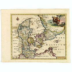
Regni Daniae accuratissima delineatio.
A delightful, attractive small map of Denmark by Philipp Cluver, published in the early years of the eighteenth century. The map has nice, eye catching coloring, enhanced...
Date: London, 1711
Selling price: ????
Please login to see price!
Sold in 2018
Nova totius geographica telluris projectio. . .
This is the first atlas of Gerard Valk, publisher, engraver and manufacturer of globes in Amsterdam. The latter joined in 1673 Petrus Schenck for the publication of maps....
Date: Amsterdam, ca. 1711
Selling price: ????
Please login to see price!
Sold in 2023
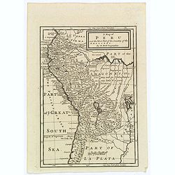
A Map of Peru and the West Part of the Country of the Amazones.
A map showing a good proportion of the west coast of South America, covering Peru, Chile, Western Brazil and Quito (Equador). Many coastal settlements and towns are engra...
Date: London, 1711
Selling price: ????
Please login to see price!
Sold in 2019
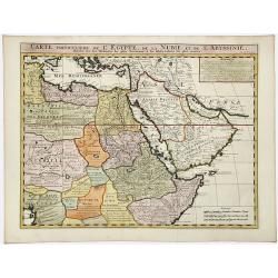
CARTE Particuliere de L' EGYPTE, de la NUBIE, et de L' ABYYSSINIE.
Detailed map of Cyprus, Asia Minor, the Middle East and North Africa, colored by regions.
Date: Amsterdam, 1711
Selling price: ????
Please login to see price!
Sold in 2020
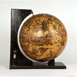
Celestial globe 15 inch (only 3 other copys known.)
Title below Cetus in a cartouche : Uranographia Caelum omne hic Complectens, Illa pro ut aucta et ad annum 1700 Completum MAGNO ab HEVELIO correcta est: ita, ejus ex Prot...
Date: Amsterdam, c. 1711
Selling price: ????
Please login to see price!
Sold
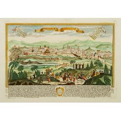
Hierosolyma. - Jerusalem
A rare and beautifully engraved and richly detailed panoramic view of Jerusalem. With in lower part description of Jerusalem in German and Latin. Published by Joseph Frie...
Date: Augsburg 1711
Selling price: ????
Please login to see price!
Sold
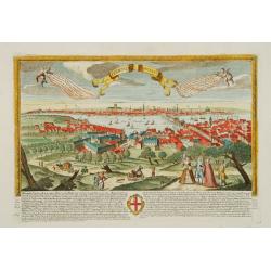
Londinum - London
A rare and beautifully engraved and richly detailed panoramic view of London. With in lower part description of London in German and Latin. Published by Joseph Friederich...
Date: Augsburg 1711
Selling price: ????
Please login to see price!
Sold
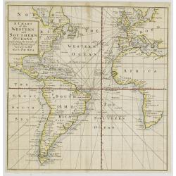
A Chart of the Western and Southern Oceans.
Copper engraved chart of the Atlantic showing the eastern part of North America, all of South America, and most of Europe and Africa. The tract of the voyage of John Narb...
Date: London, 1711
Selling price: ????
Please login to see price!
Sold
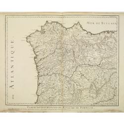
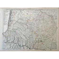
Partie Septentrionale du Royaume de Portugal.
Detailed map of the northern part of Portugal and the northern tip of Morocco. Complementing with lot 08314.
Date: Paris, 1711
Selling price: ????
Please login to see price!
Sold in 2011
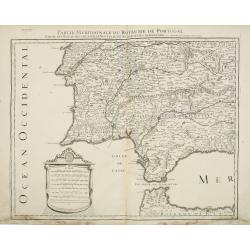
Partie Meridionale du Royaume de Portugal. . .
Detailed map of the southern part of Portugal and the northern tip of Morocco. Fine-scale cartouche. Complementing with lot 08315.
Date: Paris, 1711
Selling price: ????
Please login to see price!
Sold in 2011
La Marca Anconitana, e Fermana . . .
A uncommon map of part of the March regions in the province of Ancon in central Italy. Based on the reports of Giacomo Cantelli da Vignola and published in Roma in Giacom...
Date: Rome, ca. 1711
Selling price: ????
Please login to see price!
Sold in 2009
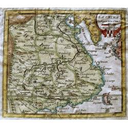
La China.
Map of China from Laso’s extremely rare atlas “El Atlas Abreviado”. The plates for the atlas were based on those for Don Francisco De Afferden’s earlier atlas pub...
Date: Madrid, 1711
Selling price: ????
Please login to see price!
Sold in 2012
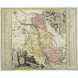
Accurate geographische delineation des stiffts ambst Wurtzen nebst. . .
Detailed map of the Saxony area along the Mulde River, with Eilenburg, Bad Düben and Wurzen to the northeast of Leipzig with two very decorative vignettes/cartouches wit...
Date: Amsterdam, 1711
Selling price: ????
Please login to see price!
Sold in 2021
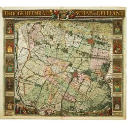
't Hooge Heemraedschap van Delflant.
Beautifully engraved map, a reduced from of the wall map, of 't Hooge Heemraedschap van Delfland prepared by Nicolaas and Jacob Kruikius. Decorated with the Delfland coat...
Date: Delft, 1712
Selling price: ????
Please login to see price!
Sold
De stadt Korfu, eertytss Korcyra in 't verschiet.
A beautifully engraved and richly detailed panoramic view of the town of Corfu. In lower part a key to five principal spots in the town. From Galerie Agréable du Monde, ...
Date: Leiden 1712
Selling price: ????
Please login to see price!
Sold
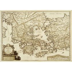
Graecia Sophiani per Abrahamum Ortelium..
A beautifully engraved and richly detailed map of Ancient Greece, after Abraham Ortelius who is given credit in the title. Engraved by J.stemmers.From Galerie Agréable d...
Date: Leiden 1712
Selling price: ????
Please login to see price!
Sold
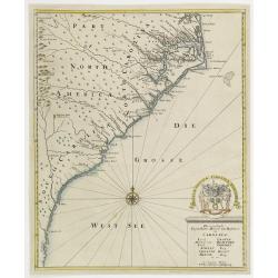
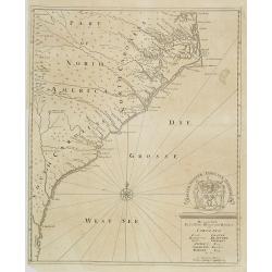
Die vornehmste Eigenthums Herren und Befitzer von Carolina..
Complete title in cartouche lower right : Die vornehmste / Eigenthums Herren und Besitzer / von / CAROLINA. / Lord CRAVEN. / Hertzog von BEAVFORT. / Lord CARTERET. / ASHL...
Date: Hamburg, 1712
Selling price: ????
Please login to see price!
Sold
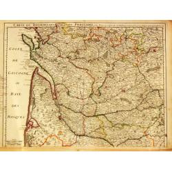
Carte du Bourdelois du Perigord et des Provinces voisines.
Guillaume de l' Isle (1675-1724), Royal Geographer, was the most influential cartographer of the first quarter of the 18th century. 'Atlas de Géographie' (1700-12), post...
Date: Paris, 1712
Selling price: ????
Please login to see price!
Sold
Die vornehmste Eigenthums Herren und Befitzer von Carolina..
Complete title in cartouche lower right : Die vornehmste / Eigenthums Herren und Besitzer / von / CAROLINA. / Lord CRAVEN. / Hertzog von BEAVFORT. / Lord CARTERET. / ASHL...
Date: Hamburg, 1712
Selling price: ????
Please login to see price!
Sold in 2009
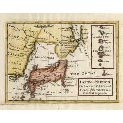
Iapon or Niphon, The Land of Iesso and Straits of the Vries &c.
This small, uncommon map of Japan, drawn on the Blaeu/Martini model, depicts a compact Honshu. The Land of Iesso is joined with the mainland and a faintly engraved coastl...
Date: London, 1712
Selling price: ????
Please login to see price!
Sold in 2009
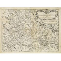
Tavola Generale della Provincia dell' Umbria . . .
An uncommon, map of part of the Umbria region, based on the reports of Giacomo Cantelli da Vignola and published in Roma in Giacomo de Rossi's world atlas "Mercurio ...
Date: Rome, ca. 1712
Selling price: ????
Please login to see price!
Sold in 2009
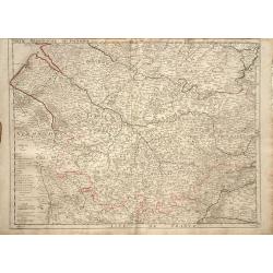
Partie Meridionale de Picardie
Finely detailed map of the Picardy region of northwestern France., including the regional capital of Amiens in the center of the map. A map key is in the bottom left corn...
Date: Paris, 1712
Selling price: ????
Please login to see price!
Sold in 2010
Carte du Bearn de la Bigorre de L'Armagna et des Pays Voisins.
Map of the Pyrenees Mountains regions of France and Spain. Depicts the regions of Aquitaine and Midi-Pyrenees in France and Navarra in Spain. Also, shows abbeys by religi...
Date: Paris, 1712
Selling price: ????
Please login to see price!
Sold in 2010
A new map of the north of antient Africa. . .
Decorative map of the north part of Ancient Africa. East to the top.This decorative map was part of a set of 22 maps dedicated to William, Duke of Gloucester, who was the...
Date: Oxford, 1712
Selling price: ????
Please login to see price!
Sold in 2011
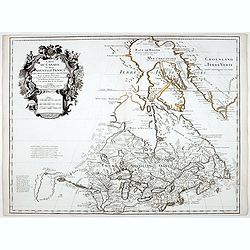
Carte du Canada ou de la Nouvelle France.
Fourth state of the map of Canada published by Delisle with the imprint "sur le Quai de l’Horloge a l’Aigle d’Or avec Privilege pour 20 ans, 1703". Beneat...
Date: Paris, 1703/1708-1712
Selling price: ????
Please login to see price!
Sold in 2020
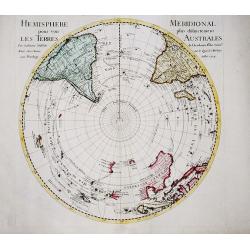
Hemisphere Meridional pour voir plus distinctement les Terres Australis. 1714.
First edition of de l'Isle's important circular polar-projection map of the southern hemisphere. De l'Isle with his scientific approach leaves the Polar area completely b...
Date: Paris, 1712
Selling price: ????
Please login to see price!
Sold in 2021
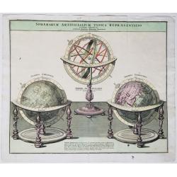
Sphaerarum artificialium typica repraesentatio, novissime adumbrata.
Decorative print with illustrations of three scientific instruments: from left to right a celestial globe, an armillary sphere and a terrestrial globe. The armillary has ...
Date: Nuremberg, 1712
Selling price: ????
Please login to see price!
Sold in 2020
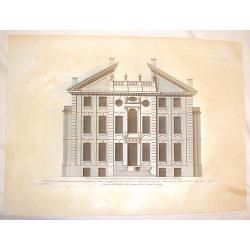
The Elevation of Rowhampton House in Surrey, the seat of Thomas Cary.
Fine steel engraving of the Rowhampton House in Surrey.Colen Campbell (1676–1729) was a pioneering Scottish architect and architectural writer, credited as a founder of...
Date: London, 1712
Selling price: ????
Please login to see price!
Sold in 2016
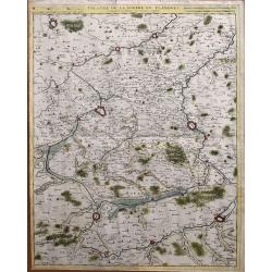
Theatre de la guerre en Flandres.
Unusual large-scale map of the French-Belgium border. Shows the area from Douai and Valenciennes to Ypres/Ieper and Courtrai/Kortrijk. Includes Roubaix, Lille, and Tourna...
Date: Brussels, 1712
Selling price: ????
Please login to see price!
Sold in 2014
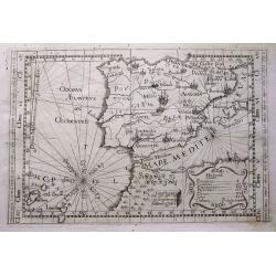
Tabula totius Hispaniae.
Scarce map extending from Madeira and Lanzarote, to the border of France. Published in Montecalerio's "Chorographica descriptio Provinciarum et Conventuum Fratrum mi...
Date: Rome, 1643-1712
Selling price: ????
Please login to see price!
Sold in 2016
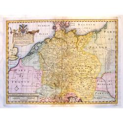
A New Map of Present Germany, Shewing Its Principal divisions, Cities, Towns, Rivrs, Mountains &c.
A fine copper engraved map of "Present Germany". Fancy, large title cartouche with the coat of arms of William, Duke of Gloucester, son of Queen Anne, to whom t...
Date: London, 1712
Selling price: ????
Please login to see price!
Sold in 2015
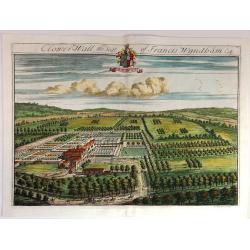
Clower-Wall the Seat of Francis Wyndham, Esq.
A large, fine, copper engraved print illustrating a birds-eye view of Clower-Wall, the Seat of Francis Wyndham, Esq.Published in 1712 for Robert Atkyns. Drawn and engrave...
Date: London, 1712
Selling price: ????
Please login to see price!
Sold in 2019
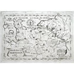
Provincia Normaniae.
Scarce map of Normandy, extending from the Channel Islands to Paris. Published in Montecalerio's "Chorographica descriptio Provinciarum et Conventuum Fratrum minorum...
Date: Rome, 1643-1712
Selling price: ????
Please login to see price!
Sold in 2016
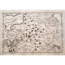
Prova Parisiensis...
Scarce map centred on Paris and extending from Calais to Auxerre, and east until Metz. Published in Montecalerio's "Chorographica descriptio Provinciarum et Conventu...
Date: Rome, 1643-1712
Selling price: ????
Please login to see price!
Sold in 2016
![Wakan Sansai Zue - 和漢三才図会 [Illustrated Sino-Japanese Encyclopedia - one volume]](/uploads/cache/39548-250x250.jpg)
Wakan Sansai Zue - 和漢三才図会 [Illustrated Sino-Japanese Encyclopedia - one volume]
The Wakan Sansai Zue (和漢三才図会, lit. "Illustrated Sino-Japanese Encyclopedia") is an illustrated...
Date: Edo, 1712
Selling price: ????
Please login to see price!
Sold in 2017
Plan et Profil de la Ville de Maubeuge.
A detailed plan of the town and profile of Maubeuge. Maubeuge is a commune in the Nord department in northern France. It is situated on both banks of the Sambre River, e...
Date: Amsterdam, 1712
Selling price: ????
Please login to see price!
Sold in 2019
Amoenitatum exoticarum politico-physico-medicarum fasciculi V.
> FIRST EDITION OF KAEMPFER'S FIRST WORK ON ASIAN NATURAL HISTORY AND MEDICINE, the only book Kaempfer published during his lifetime. The book includes on page 764 &qu...
Date: Lemgo: Heinrich Wilhelm Meyer, 1712
Selling price: ????
Please login to see price!
Sold
![Wakan Sansai Zue (和漢三才図会 [Illustrated Sino-Japanese Encyclopedia - one volume].](/uploads/cache/40338-250x250.jpg)
Wakan Sansai Zue (和漢三才図会 [Illustrated Sino-Japanese Encyclopedia - one volume].
The Wakan Sansai Zue (和漢三才図会, lit. "Illustrated Sino-Japanese Encyclopedia") is an illustrated...
Date: Edo, 1712
Selling price: ????
Please login to see price!
Sold in 2017
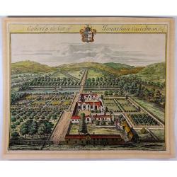
Coberly the Seat of Jonathan Castelman Esq.
A fine, large, detailed birds-eye view of Coberly by Kip, who produced the engravings for the remarkable "The Ancient & Present State of Gloucestershire", p...
Date: London, 1712
Selling price: ????
Please login to see price!
Sold in 2023
A New Map of The Eastern Parts of Asia Minor. . .
A very pleasant map showing eastern Turkey, Cyprus, the Holy Land, Armenia, Lebanon, Syria, and Iraq. Map features a decorative title cartouche, and the heraldic arms of ...
Date: Oxford, ca. 1712
Selling price: ????
Please login to see price!
Sold in 2018
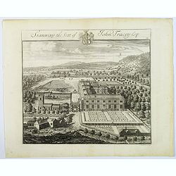
Stanway, the Seat of John Tracey Esq / Didmartin, the Seat of Robert Codrington Esq.
An attractive, and striking pair of early eighteenth century copperplate engravings of staely English homes, from Sir Robert Atkyn's The Ancient and Present State of Glou...
Date: London, ca 1712
Selling price: ????
Please login to see price!
Sold in 2018
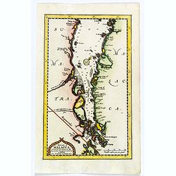
Le détroit de Malacca.
A map of the Strait of Malacca between the Malay Peninsula and the Indonesian island of Sumatra. The north is towards the top right corner. The map details the Strait of ...
Date: Leiden, 1712
Selling price: ????
Please login to see price!
Sold in 2019
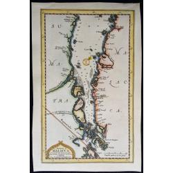
Le Detroit de Malacca. . .
Map of Malacca. The map details the Strait of Malacca from P. Pera and Tanjong Goeree to Lingen and Pulu Panjang. Malacca and Ihor (Johore), along with numerous other coa...
Date: Leiden, 1712
Selling price: ????
Please login to see price!
Sold in 2020