Browse Listings in World Maps
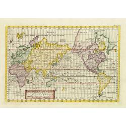
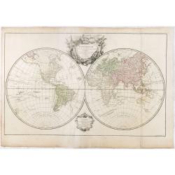
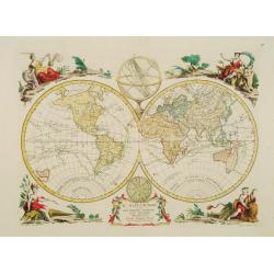
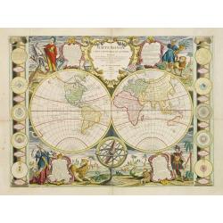
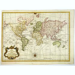
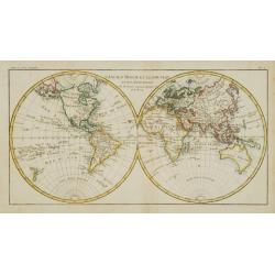
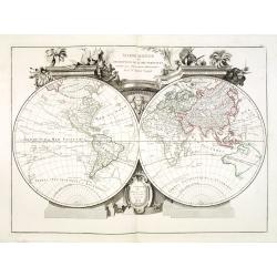
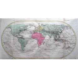
Carte generale du globe terrestre construite & publiee par le S.r Isaac Brouckner geographe de S.M.I.C. exaninee & approuvee par M.r Daniel Bernoulli . . .
Attractive Italian world map presented in Mercator's projection and centered on Australia. Included in "Dizionario geografico portatile".Featuring the voyage of...
Date: Venice, 1761
Selling price: ????
Please login to see price!
Sold in 2011

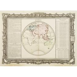
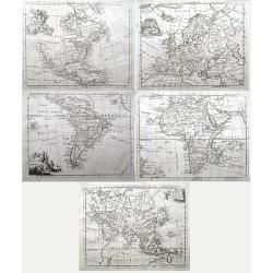
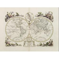
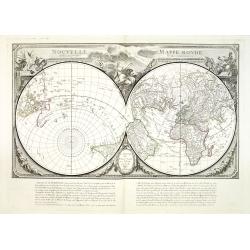
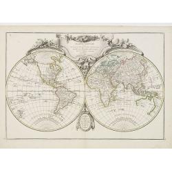
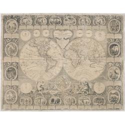
Matching set of four wallmaps of America, Asia, America, Europe.
Rare and decorative set of four wall maps published by Louis Charles DESNOS ( fl.1750-1770), including a border with vignettes describing native scenes. Each panel is acc...
Date: Paris, 1760-1761

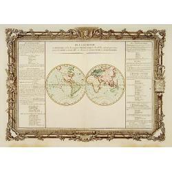
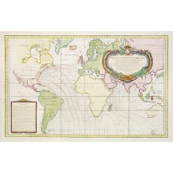
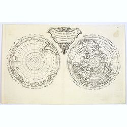
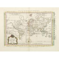
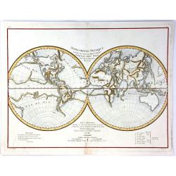
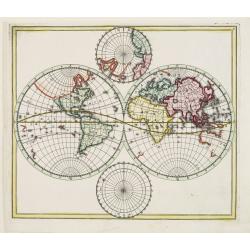
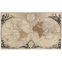
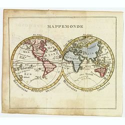
Climats d'Heures et de Mois.
Decorative map of the world showing one hemisphere divided into climates according to the length of the day.Left and right a box with information about these climates.Pre...
Date: Paris, 1761
Selling price: ????
Please login to see price!
Sold in 2009
![SUITE DE L'HISTOIRE DES GOMERITES [ANCIENT GREEK MYTHOLOGICAL WORLD VIEW]](/uploads/cache/84967-250x250.jpg)
SUITE DE L'HISTOIRE DES GOMERITES [ANCIENT GREEK MYTHOLOGICAL WORLD VIEW]
A scarce map of the Ancient World. It includes plenty of french text and remarkably decorative borders found only in the deluxe edition of Buy De Mornas' 'Atlas Methodiqu...
Date: Paris, 1761
Selling price: ????
Please login to see price!
Sold in 2021
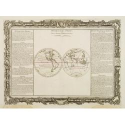
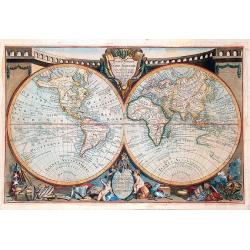
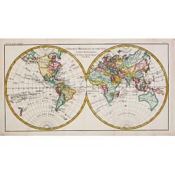
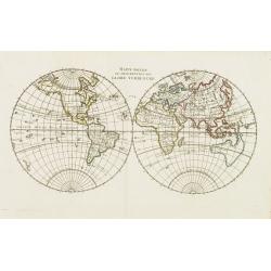
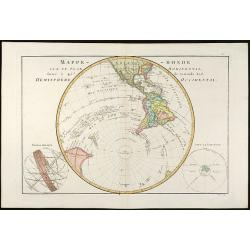
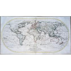
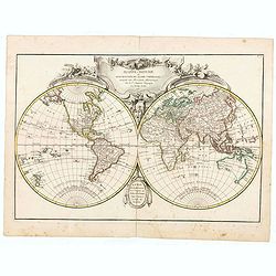
Hémisphére Occidental.
Double hemisphere world map.Left and right a box with geographical information for spheres of different types.Prepared by Buy de Mornas, who was a professor of geography ...
Date: Paris 1762
Selling price: ????
Please login to see price!
Sold
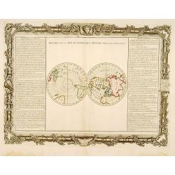
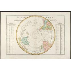
Histoire de la Découverte des Mondes Nouveau et Inconnu.
Double hemisphere map of the Arctic and Antarctic poles.Left and right a box with geographical information about the discovery of America and the arctic and Antarctic ear...
Date: Paris 1762
Selling price: ????
Please login to see price!
Sold
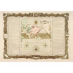
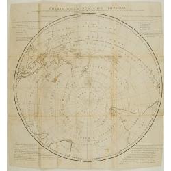
Pour les Vents.
Finely engraved chart shows the wind currents in the Atlantic, Indian and Pacific Oceans, and the Arctic and Antarctic regions. Depicts 4 compass roses with wind directio...
Date: Paris 1762
Selling price: ????
Please login to see price!
Sold
De la Longitude et de la Latitude.
Decorative map showing the division of the two hemispheres respectively into parallels and meridians.Left and right a box with information's about latitude and longitude....
Date: Paris 1762
Selling price: ????
Please login to see price!
Sold
Suite de la Longitude.
Decorative map showing one hemisphere divided into meridians.Left and right a box with further information's about longitude.Prepared by Buy de Mornas, who was a professo...
Date: Paris, 1762
Selling price: ????
Please login to see price!
Sold in 2013
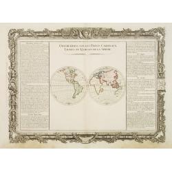
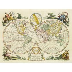
Observations sur les Points Cardinaux. Lignes et Cercles de..
Decorative world map presenting the four cardinal points on two hemispheres.Left and right a box with information about the cardinal points as well as the lines and the c...
Date: Paris, 1762
Selling price: ????
Please login to see price!
Sold in 2008
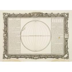
Diversité Des Ombres et Diverse Situation des Habitants de la Terre.
Decorative map of the world showing the system of shadows on the Earth depending on the different latitude and longitude degrees.Left and right a box with technical terms...
Date: Paris 1762
Selling price: ????
Please login to see price!
Sold
Climats d'Heures et de Mois.
Decorative map of the world showing one hemisphere divided into climates according to the length of the day.Left and right a box with information about these climates.Pre...
Date: Paris 1762
Selling price: ????
Please login to see price!
Sold
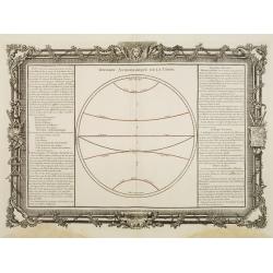
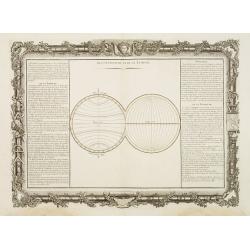
Division Astronomique de la Terre.
Decorative map of the world showing the astronomical division of the Earth as made by the geometricians.Left and right a box with information about the main lines, points...
Date: Paris 1762
Selling price: ????
Please login to see price!
Sold
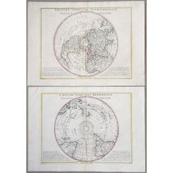
Observations sur les Points Cardinaux. . .
Decorative world map illustrating the cardinal points on the two hemispheres. Left and right with lengthy text about the cardinal points as well as the lines and the circ...
Date: Paris, 1762
Selling price: ????
Please login to see price!
Sold in 2014
![[ Lot of 6 world and thematic maps ] Climats d'Heures et de Mois.](/uploads/cache/IMG_0772-250x250.jpg)
[ Lot of 6 world and thematic maps ] Climats d'Heures et de Mois.
A map of the Ancient World with the climate circles. On both sides a description text. All within an elaborate and very decorative border. A very fine item.Claude Buy...
Date: Paris, 1762
Selling price: ????
Please login to see price!
Sold in 2023
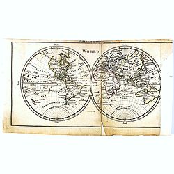
(Mappe monde) World.
Uncommon miniature world map, engraved by Thomas Kitching for "A New General and Universal Atlas Containing Forty five Maps by Andrew Dury".This miniature atlas...
Date: London, 1761-1763
Selling price: ????
Please login to see price!
Sold in 2016
Mappemonde dressée suivant les nouvelles relations et assujettie aux observations astronomiques Par le S. Robert de Vaugondy. . .
World map in double hemispheres showing numerous tracks, among Anson, Cooke, Tasman and the Gold Galleons.With privilege of 1764, not mentioned by Pedley. Engraved by the...
Date: Paris, 1764
Selling price: ????
Please login to see price!
Sold in 2018
Set of four continents (Maps of North America; South America; Asia; Europe; Africa;)
Interesting set of five detailed maps of the continents. North America with large unexplored parts. Asia with unfinished coast lines and showing a "Companys Land&quo...
Date: London, 1764
![De la Geologie. Du Zodiaque et du L' Eclyptique, Explication des Saisons. [Lot of 3 maps]](/uploads/cache/IMG_0104-250x250.jpg)
De la Geologie. Du Zodiaque et du L' Eclyptique, Explication des Saisons. [Lot of 3 maps]
Claude Buy de Mornas (d. 1783), géographe du roi (1764). Atlas Méthodique et Elémentaire de Géographie et d' Histoire, 1761, Atlas Historique et Géographique, 1762. ...
Date: Paris, 1762-1764
Selling price: ????
Please login to see price!
Sold in 2023
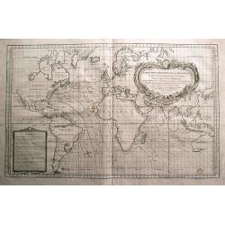
Carte Des Variations De La Boussole Et Des Vents Généraux Que L' On Trouve Dans Les Mers Les Plus Frequentées..
An elegantly designed chart of the oceans, according to the title "most frequently sailed by French navigators" in the eighteenth century. Drawn by J. N. Bellin...
Date: Paris, 1765
Selling price: ????
Please login to see price!
Sold in 2008
Mappemonde ou globe terestre dressée sur les Nouvelles Observations . . .
Scarce, spectacular world map which includes most of the major discoveries of the 18th-century explorers like Cook, Bougainville, Halley, etc. The maker, Jean Baptiste Lo...
Date: Peris, 1765
Selling price: ????
Please login to see price!
Sold in 2018
Carte des variations de la boussole...
Very large sea-chart of the world, showing compass variation and winds. The winds are shown by small cherubs! Australia is shown with unfinished coastline and named "...
Date: Paris, 1765
Selling price: ????
Please login to see price!
Sold in 2014
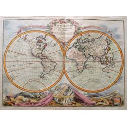
Mappe Monde Carte Universelle De La Terre Dressee Sure les Nouvelles Observations de Mrs. De L'Academie Royael Des Sciences.
Rare and fascinating double hemisphere map of the World. Includes a massive "Mer de l'Ouest" in the Northwest of North America. Further with text in French such...
Date: Paris, 1766
Selling price: ????
Please login to see price!
Sold in 2014
Carte pour l'intelligence du Livre Institule de L'Espirit des Loix.
A supplementary World map by R. de Vaugondy, included in the multivolume work by Baron de Montesquieu "The Spirit of the Laws." Box title, Tasmania is still par...
Date: Paris, ca. 1767
Selling price: ????
Please login to see price!
Sold in 2023
Le Globe Terrestre vû en convêxe par les deux Poles...
Scarce map showing the World in twin-hemispheres, centered on the Poles. Ornamental uncolored title cartouche. Northern Hemisphere shows large "Mer de l'Ouest"....
Date: Paris, 1769
Selling price: ????
Please login to see price!
Sold
Le Globe Terrestre vu en convexe par les deux Poles, l'Equateur servant d'horison.
The rare double polar hemisphere world map, based on Cassini's projection. There are some geographical anomalies, Greenland is connected to Canada, the Mer de l'Ouest in ...
Date: Paris, 1769
Selling price: ????
Please login to see price!
Sold in 2017
![Mappemonde Terrestre.. [manuscript map]](/uploads/cache/16358-250x250.jpg)
Mappemonde Terrestre.. [manuscript map]
Manuscript double hemisphere world map in brown ink with water color. Finely executed on paper. Showing a north and south pole projection at an angle of 45degrees.
Date: Paris c.1770
Selling price: ????
Please login to see price!
Sold
L' Ancien Monde et le Nouveau en deux Hemispheres.
Rigobert Bonne (1727-1795), French cartographer. His maps are found in a.o. Atlas Moderne (1762), Raynal's Histoire Philos. du Commerce des Indes (1774) and Atlas Encyclo...
Date: Paris, c. 1770
Selling price: ????
Please login to see price!
Sold
Planisphaerium. Orbis terrarum
Lovely double hemisphere map from Hubner's Lexicon. CALIFORNIA IS AN ISLAND. Diagrams of the Copernican and Ptolemaic solar systems in the corners.
Date: Leipzig, ca.1770
Selling price: ????
Please login to see price!
Sold in 2008
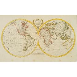
A map of the world from the latest authorities.
Fine double hemisphere world map engraved by Thomas Kitchin.The boundaries of both Australia and New Zealand are not yet completely defined. The northwest coast of North ...
Date: London 1771
Selling price: ????
Please login to see price!
Sold
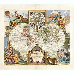
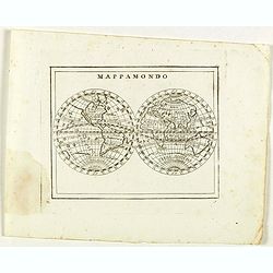
Il Mappamondo o sia Descrizione Generale del Globo
Double-hemisphere world, with allegorical figures of the Four Continents in the corners. Published just after the news of Cook's first circumnavigation was published, his...
Date: Venice 1774
Selling price: ????
Please login to see price!
Sold
Il Mappamondo o sia Descrizione Generale del Globo Ridotto..
Attractive Italian map presented on Mercator's projection and featuring the voyages of Cook and Bougainville. Greenland is shown connected to North America and Alaska is ...
Date: Venice, 1774
Selling price: ????
Please login to see price!
Sold in 2010
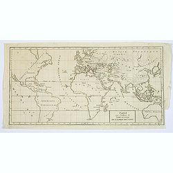
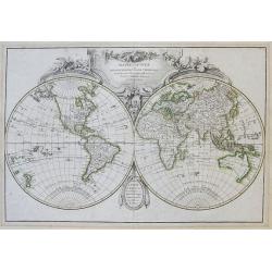
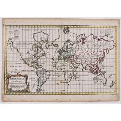
Mappe Monde ou Description du Globe Terrestre.
World map dated 1774, with Russian discoveries but no de la Fuente geography. Tasmania connected to the continent of Australia. From Atlas Portatif Universel, by Robert d...
Date: Paris, 1774
Selling price: ????
Please login to see price!
Sold in 2008
Il Mappamondo o sia Descrizione Generale del Globo
Double-hemisphere world, with allegorical figures of the Four Continents in the corners. Published just after the news of Cook's first circumnavigation was published, his...
Date: Venice, 1774
Selling price: ????
Please login to see price!
Sold in 2011
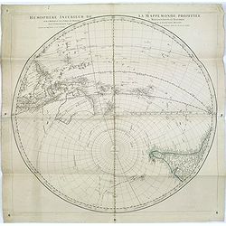
Hémisphere inférieur de la mappemonde projettée sur l'horizon de Paris,. . .
Hemispherical map of Southern Hemisphere showing Australia, New Zealand, islands in the Pacific, most of South East Asia, and the southern half of South America. Australi...
Date: Paris, 1774
Selling price: ????
Please login to see price!
Sold in 2016
Il Mappamondo o sia Descrizione Generale del Globo Terrestre ed Acquatico.
Double-hemisphere world, with allegorical figures of the Four Continents in the corners. Published just after the news of Cook's first circumnavigation was published, his...
Date: Venice, 1774
Selling price: ????
Please login to see price!
Sold in 2015
Mappe-Monde ou Description Du Globe Terrestre...
Large and very decorative double hemisphere map of the world, updated after Captain Cook's 1st voyage and the exploration of Dufresne from 1772. Shows an updated, but sti...
Date: Paris, 1775
Selling price: ????
Please login to see price!
Sold in 2015
Le Globe Terrestre represente en deux plans-hemispheres dresee. . .
A very fine example of the Jean-Baptiste Crepy version of Jean Baptiste Nolin's striking large wall map of the World. The present example represents the 1775 state of the...
Date: Paris, 1775
Selling price: ????
Please login to see price!
Sold in 2020
Mappe Monde Carte universelle de la Terre Dressée Sur les Re . . .
Prepared by J.B.Nolin. Decorative map of the world in two hemispheres surrounded by allegorical figures of the continents, armillary spheres and planetary systems at side...
Date: Paris, 1777
Selling price: ????
Please login to see price!
Sold in 2008
Charte von der Südlichen halbkugel..
This south polar view of the world details the tracks of Cook's voyages by (Johann) Georg (Adam) Forster (1754-1796) who carried out his father's ambition to publish the ...
Date: Berlin 1778
Selling price: ????
Please login to see price!
Sold
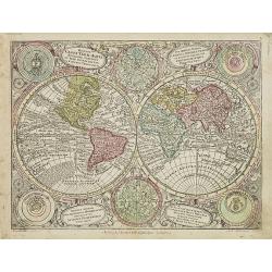
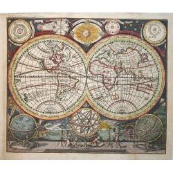
Diversi Globi Terr-Aquei Statione Variante et Visu Intercedente per Coluros Tropicorum. . .
Map of the world in two hemispheres, with smaller celestial spheres and diagrams of the solar system according to Ptolemy, Tycho Brahe, Copernicus and Descartes.From Atla...
Date: Augsburg, J.M.Will, 1778
Selling price: ????
Please login to see price!
Sold in 2010
Mappe Monde suivant la projection des cartes reduites.
Original antique copperplate-engraved 1778 map by Robert de Vaugondy on Mercator's Projection, with original outline color showing the areas associated with the four majo...
Date: Paris, 1778
Selling price: ????
Please login to see price!
Sold in 2019
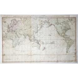
Essay d'une carte reduite contenant les parties connuees Du Globe Terrestre. . .
An attractive example of J. N. Bellin's 1778 nautical chart of the world. It presents the world on 'Mercator's Projection' and is based on a Paris meridian. North America...
Date: Paris, [1748] 1778
Selling price: ????
Please login to see price!
Sold in 2023
Il Mappamondo o sia Descrizione Generale del Globo.
Double-hemisphere world, with allegorical figures of the Four Continents in the corners. Published just after the news of Cook's first circumnavigation was published, his...
Date: Venice 1779
Selling price: ????
Please login to see price!
Sold
Mappe-Monde Physique d'Apres les Vues du Profr. Pallas Redigees par Andre Mongez
An unusual map of the world with physical topography that reveals mountain ranges both on land and under the sea.The curious undersea mountain ranges displayed here were ...
Date: Paris, 1779
Selling price: ????
Please login to see price!
Sold in 2018
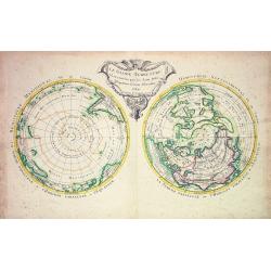
Emisfero terrestre Meridionale Tagliato Su l'Equatore & Emisfero terrestre Settentrionale Tagliato su l'equatore.
Pair of Polar Projections of the Northern & Southern Hemisphere. From: Antonio Zatta, 'Atlante Novissimo, illustrato ed accresciuto sulle osservazioni, e scoperte fat...
Date: Venice, 1779
Selling price: ????
Please login to see price!
Sold in 2022
L'Ancien Monde et le Nouveau.
A bold border and decorative title cartouche enclose this map of the world. The double hemisphere includes the peninsular of California, a filled-in Northwest coast of No...
Date: Paris 1780
Selling price: ????
Please login to see price!
Sold
World map.
Elaborately engraved double hemisphere map, showing California as an island. Taken from the rare Atlas methodicus explorandis juvenum profectibus in studio geographico ad...
Date: Nuremberg, 1780
Selling price: ????
Please login to see price!
Sold in 2016
Mappe-Monde Sur Le Plan De L\'Equateur HémisphÞre Méridional
Beautiful colored map of the southern hemisphere by Rigobert Bonne.
Date: Paris, 1780
Selling price: ????
Please login to see price!
Sold in 2009
Mappe-Monde sur un Plan Horizontal, situé Ó 45d de latitude Sud. Hemisphire Occidental
Beautiful colored map of the Southwestern Hemisphere by Rigobert Bonne.
Date: Paris, 1780
Selling price: ????
Please login to see price!
Sold in 2009
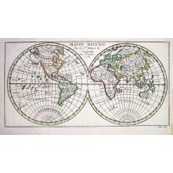
Mappemonde ou Description du Globe. . .
Attractive large double hemisphere map based on the Janvier map of the same title, but with different decorations. The map depicts several routes of exploration up to the...
Date: Venice, 1780
Selling price: ????
Please login to see price!
Sold in 2013
Nouvelle Mappe Monde dediee au progres de nos connoissances.
A handsome and well engraved world map constructed with the prime meridian through Paris. The hemispheres are rotated through 45 degrees. This is an unusual projection fo...
Date: Venice, 1780
Selling price: ????
Please login to see price!
Sold in 2013

Nouvelle Mappe Monde dediee au progres de nos connoissances.
A handsome and well-engraved world map constructed with the prime meridian through Paris. The hemispheres are rotated through 45 degrees. This is an unusual projection fo...
Date: Venice, 1780
Selling price: ????
Please login to see price!
Sold in 2018
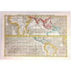
Carte de la Direction des Vents Generaux dt des Moussons.
A very interesting chart that shows the direction of the trade winds and monsoons. Comprised of two charts of the world, one on each side of the equator. The upper map sh...
Date: Paris, 1780
Selling price: ????
Please login to see price!
Sold in 2017
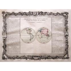
Carte des Transmigrations et des Etablissemens de Celtes ou Comerites et des Scythes.
An interesting map of transmigrations and establishments of the Celts and the Scythians. It includes Europe, North Africa and Western Asia.Louis Brion de la Tour (1756-18...
Date: Paris, 1780
Selling price: ????
Please login to see price!
Sold in 2020
Mappamondo.
Rare world map from "Atlante Novissimo ad uso Dei Giovani Studiosi Contenuto In Carte XXVII.", published by Giovanni Zempel in Rome, ca. 1780.The map is based o...
Date: Rome, 1780
MAPPE MONDE par le...
Small but detailed map of the world in two hemispheres. Shows unfinished coastline of Australia with Tasmania and New Guinea suggested to be connected to the continent.
Date: Paris, 1781
Selling price: ????
Please login to see price!
Sold
![Carte Physique de la Mer Glaciale Arctique ou se voyent les particularites de cetter Mer et le Bassin Terrestre... [Bay of the West]](/uploads/cache/33075-250x250.jpg)
Carte Physique de la Mer Glaciale Arctique ou se voyent les particularites de cetter Mer et le Bassin Terrestre... [Bay of the West]
Scarce seminal map of the Northern Hemisphere after Philippe Buache's map and published by L.J. Mondhare for his Atlas Général a l'usage des colleges et maisons d'educa...
Date: Paris, 1781
Selling price: ????
Please login to see price!
Sold in 2021
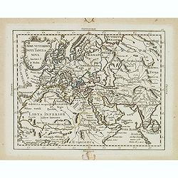
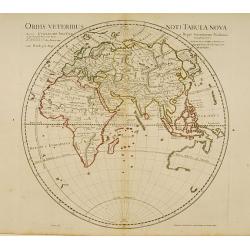
Orvis veteribus novi tabula nova. . .
Scarce map of the Ancient world, prepared by Nolin and published by L.J. Mondhare for his Atlas Général a l'usage des colleges et maisons d'education.. Louis Joseph Mon...
Date: Paris, 1781
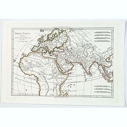
Orbis Vetus.
Rigobert Bonne's map of the ancient world, published in Paris towards the end of the eighteenth century. It shows most of Africa, the Middle East, Persia, a good deal of ...
Date: Paris, ca 1781
Selling price: ????
Please login to see price!
Sold in 2021
Mappemonde ou Carte Générale de l'Univers...
Important oval shaped map of the world, showing the tracks of Captain Cooks three famous voyages. One of the first world maps to show Hawaii. Early geography of Australi...
Date: Augsburg, 1782
Selling price: ????
Please login to see price!
Sold in 2014

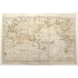
Carte Reduite du globe Terrestre..
Fine world map in a Mercator projection. From Voyages autour du monde et vers les deux pôles par terre et par mer.. by Pierre Marie François vicomte de Pages (1748-1793...
Date: Paris, ca 1782
Selling price: ????
Please login to see price!
Sold
Mappe-Monde ou description du Globe Terrestre..
Attractive double hemisphere world map, surmounted by a finely engraved and elaborate title piece. A good example of elegant French cartography. This edition dated 1782.
Date: Paris, 1782
Selling price: ????
Please login to see price!
Sold in 2011
Mappe-Monde géo-hydrographique ou description génerale du globe. . . Des nouvelles découvertes, faites par . . . Cook, Bougainville . . .
World in two hemispheres, showing Tasmania still joined to Australia's main land. With a color key in bottom to the voyages of Cook, Clarke, Fourneaux, Bougainville, Yves...
Date: Paris, 1782
Selling price: ????
Please login to see price!
Sold in 2011
Mappemonde ou carte generale de l`Univers ... avec le tour du monde du Lieut. Cook ...
Full title: 'Mappemonde ou carte generale de l`Univers sur une projection nouvelle d`une sphere ovale pour mieux entendre les distances entre l`Europe et Amerique avec le...
Date: Augsburg, 1782
Selling price: ????
Please login to see price!
Sold in 2020
![Hémisphère Oriental ou Ancien Monde. [2 sheets]](/uploads/cache/17189-250x250.jpg)
Hémisphère Oriental ou Ancien Monde. [2 sheets]
Two sheet, together a world map in double hemisphere published by Monhare for his Atlas Général a l'usage des colleges et maisons d'education.. The hemispheres are surr...
Date: Paris, 1783
Selling price: ????
Please login to see price!
Sold in 2020
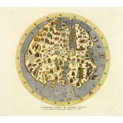
Planisfero Antico di Andrea Bianco Che si conserva in Venezia nella Biblioteca di S. Marco.
Fine and decorative presentation of Andrea Bianco's circular world map of 1436, kept in the library of the Vatican in Rome. Copper engraved version (1783) from the first ...
Date: Venice, Presso l'autore, 1783
Selling price: ????
Please login to see price!
Sold in 2011
Charte von der Südlichen Halbkugel..
German edition of Cook's hemispherical map of the Antarctic. Engraved by F.G. Berger. From J.R. Forster's "Bemerkungen über Gegenständeder physischen Erdbeschreibu...
Date: Berlin 1783
Selling price: ????
Please login to see price!
Sold
Mappe-Monde ou Description du Globe Terrestre..
World map, ornated with a large rococo title cartouche. Boundaries outlined in hand color.Prepared by Le Sieur Janvier, Jean denis [Robert], French geographer and cartogr...
Date: Paris, ca 1783
Selling price: ????
Please login to see price!
Sold
Orbis Veteribus Noti Tabula Nova. . .
Uncommon map of the Ancient world prepared by J.B.Nolin and published by Monhare for his Atlas Général a l'usage des colleges et maisons d'education.. Louis Joseph Mond...
Date: Paris, 1783
Selling price: ????
Please login to see price!
Sold
Mappemonde.
A nice small eighteenth century French double hemisphere world map. Points of interest are that Brazil, Australia and North America are all misshapen. No place names are ...
Date: Paris, ca 1783
Selling price: ????
Please login to see price!
Sold in 2021
Mappe-Monde ou Description du Globe Terrestre..
World map, ornated with a large rococo title cartouche. Boundaries outlined in hand color.Prepared by Le Sieur Janvier, Jean denis [Robert], French geographer and cartogr...
Date: Paris, ca 1783
Selling price: ????
Please login to see price!
Sold in 2020
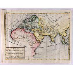
Orbis Veteribus Notus Auspiciis Serenissimi Principis..
Finely and crisply engraved map of Europe, Asia and Africa, prepared by d'Anville. With inset map of the Indochinese Peninsula in the upper left corner.Venetian edition o...
Date: Venice, 1776 - 1784
Selling price: ????
Please login to see price!
Sold in 2008
A New General Chart: Exhibiting the Discoveries made by Capt'n James Cook in His First, Second and Third Voyages; with the Tracks of the Ships Under His Command
An important map featuring the three voyages of Captain Cook and including the tracks of these voyages including place names, dates and notes. Interestingly centered on t...
Date: London, 1784
Selling price: ????
Please login to see price!
Sold in 2015
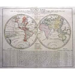
Neue Welt=Karte Welche auf zwoo Kugelflaechen die Haupt=Theile der Erde...
Double hemisphere map of the world which includes the tracks of Goree's voyage in 1780, Clerke's Voyage in 1779 and Cook's voyage in 1777-78. An early map to already show...
Date: Nuremberg, 1784
Selling price: ????
Please login to see price!
Sold in 2015
A New General Chart: Exhibiting the Discoveries Made by Capt'n James Cook in His First, Second and Third Voyages...
An important map featuring the three voyages of Captain Cook and including the tracks of these voyages including place names, dates and notes. Interestingly but appropria...
Date: London, 1784
Selling price: ????
Please login to see price!
Sold in 2017
A General Chart Exhibiting the Discoveries Made by Captn. James cook in This and his two Preceding Voyages. . .
A rare world map featuring the famous voyages and discoveries made by James Cook. The map was made by Lt. Henry Roberts who sailed as Masters Mate with Cook on board the ...
Date: London, 1784
Selling price: ????
Please login to see price!
Sold in 2020
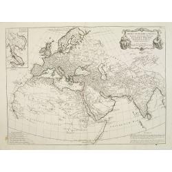
Orbis Veteribus Noti Tabula Nova.
Ancient map of the Eastern Hemisphere, with the outline of western Australia shown, Madagascar under its old name (Menuthias Island).On this map Hokkaido is even bigger d...
Date: Paris, 1785
Selling price: ????
Please login to see price!
Sold in 2018
Carte Générale de la Terre ou Mappe Monde avec les quatre principaux sistemes.
Uncommon and dramatically composed world map, prepared by Clouet. Two mythological figures supporting the two hemispheres. With superb decoration including a wonderful ro...
Date: Paris, Mondhare, 1785
Selling price: ????
Please login to see price!
Sold

Planisphere Physique ou l'on du Pole Septentrional.
Uncommon world map on a north pole projection prepared by G.de l'Isle and published by Phil. Dezauche.This map is most notable for it's depiction of "Mer de L'Ouest&...
Date: Paris, 1785
Selling price: ????
Please login to see price!
Sold in 2011
