Browse Listings in World Maps
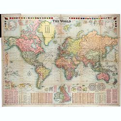
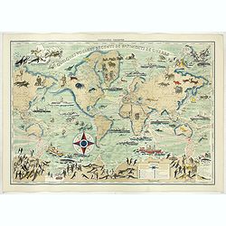
Bacon's New Chart of The World Mercator's Projection. By G.W. Bacon F.R.G.S.
Wall size format world map in Mercator projection, showing the British Empire, at its height. Around the map are inset details: with plans of towns including Hong Kong, S...
Date: London, ca. 1907
Selling price: ????
Please login to see price!
Sold in 2021
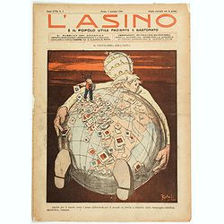
L'Asino e il popolo utile paziente e bastonato.
A satirical look at the Roman Catholic churches' ever-reaching take over of the globe. Pope Pius X is seen sitting beneath the glove, with his arms stretched as far as th...
Date: Rome, 1908
Selling price: ????
Please login to see price!
Sold in 2021

Il Papato in America.
A satirical look at the Roman Catholic church and its 'reach' and 'designs' over America. Pope Pius X is seen with his hands surrounding and enveloping 'Uncle Sam', as he...
Date: Rome, ca 1910
Selling price: ????
Please login to see price!
Sold in 2021
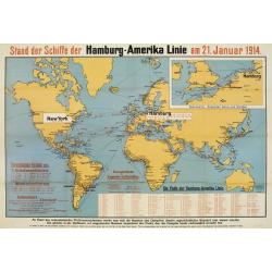
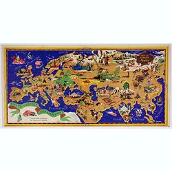
Stand der Schiffe der Hamburg - Amerika Linie am 21. Januar 1914.
Map of the world showing the routes covered by the Hamburg-Amerika fleet.In top right corner inset enlarged map of the coastline around the English Channel as well as the...
Date: Hamburg 1914
Selling price: ????
Please login to see price!
Sold
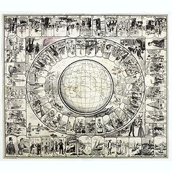
Goose board game type, on the thematic of Jules Vernes World tour in 80 days.
VERY RARE, PRINT BEFORE COLORING OR PROOF. Goose board game representing scenes from Jules Verne’s 1872 novel, with thumbnail illustrations numbered from 1 to 80 arrang...
Date: Paris, Roche Frères, 1880-1915
Selling price: ????
Please login to see price!
Sold in 2020
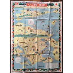
Katei kyōiku sekai isshū sugoroku.
The colorful board game about travelling around the world. Shows a very unusual projection of the world. Many nations flags create the border of the map. The game starts ...
Date: Osaka, 1926
Selling price: ????
Please login to see price!
Sold in 2016
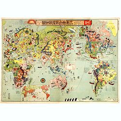
Japanese Stereotype Map of the World from 1932 Share Hitome de wakaru Manga sekai genjō chizu. At a glance: Cartoon Map of the Current World Situation. 目でわかる 漫画世界現状地圖
An extraordinary satirical map of the world was seen through Japanese eyes in the early 1930s as Japanese imperial ambitions strengthened. The map was published as an edi...
Date: Tokyo, Showa 7, or 1932
Selling price: ????
Please login to see price!
Sold in 2016
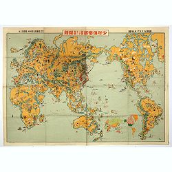
Youth Club Japanese Pictorial map of the world.
A remarkable 1933 Japanese issue pictorial map of the world drawn by Keizo Shimada and published by Yasutarou Sato. Centred on the Japanese Empire, which is highlighted i...
Date: Tokyo, Yasutarou Sato, 1933
Selling price: ????
Please login to see price!
Sold in 2019
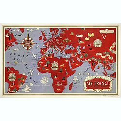
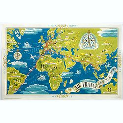
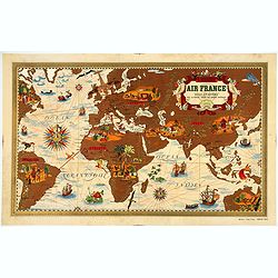
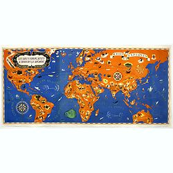
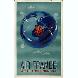
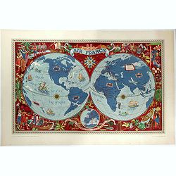
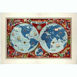
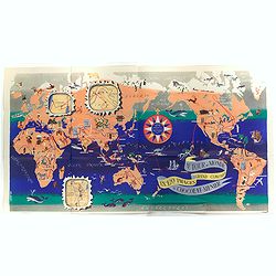
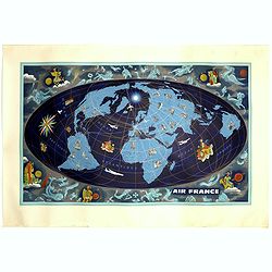
AIR France - Réseau Aérien Mondial
First Air France planisphere made by Boucher, printed by Perceval in 1934, only a year after the Air France opening. Shows the world in purple and red depicts route maps ...
Date: Imprimerie Perceval, Paris, 1934
Selling price: ????
Please login to see price!
Sold in 2020
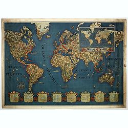
Philips Radio.
This map by Walter Eckhard (1903 - 1982) depicts a Mercator projection of the short waves Philips enabled and could be picked up by their radios. The shields at the botto...
Date: Eindhoven, ca. 1935
Selling price: ????
Please login to see price!
Sold in 2019
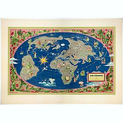
Air France - Reseau Aerien Mondial.
A lovely, large early Air France poster showing the airline's nascent worldwide network, published only four years after the airline was founded. It highlights their rou...
Date: Paris, 1937
Selling price: ????
Please login to see price!
Sold in 2021
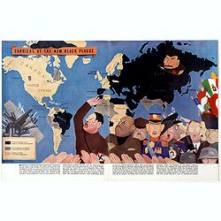
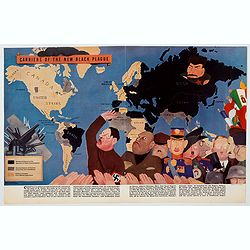
Carriers of the New Black Plague.
A powerful satirical commentary on totalitarian control of speech from the first issue of Ken Magazine. "Caught here in all their peculiar beauty by the soul searchi...
Date: Chicago, 1938
Selling price: ????
Please login to see price!
Sold in 2019
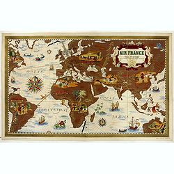
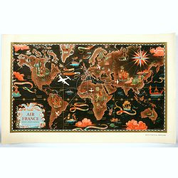
AIR France - Nova et Vetera.
Nova et Vetera " Sur la vieille terre des chemins nouveaux" original lithograph advertising planisphere poster from AIR France, the French airline company. The ...
Date: Imprimerie Perceval, Paris, 1938
Selling price: ????
Please login to see price!
Sold in 2020

Carriers of the New Black Plague.
A powerful satirical commentary on totalitarian control of speech from the first issue of Ken Magazine. "Caught here in all their peculiar beauty by the soul searchi...
Date: Chicago, 1938
AIR France - Nova et Vetera.
Original mid-sized lithographed advertising planisphere poster from AIR France. This is one of the earlier Air France maps made by Boucher, his first being in 1934. Shows...
Date: Imprimerie Perceval, Paris, 1938
Selling price: ????
Please login to see price!
Sold in 2020
Carriers of the New Black Plague.
A powerful satirical commentary on totalitarian control of speech from the first issue of Ken Magazine. "Caught here in all their peculiar beauty by the soul searchi...
Date: USA, 1938
Selling price: ????
Please login to see price!
Sold in 2021
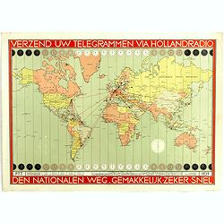
Verzend uw telegrammen via Holland Radio Den Nationalen weg. Gemakkelijk -Zeker - Snel.
Poster showing a world map in Mercator projection. In top and bottom clocks showing the time zones. Red lines connecting The Netherlands with different major hubs in Amer...
Date: The Netherland, 1939
Selling price: ????
Please login to see price!
Sold in 2019
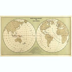
Radio Wereld Kaart om Hollandia.
Poster showing a world map in a double hemisphere projection. Showing distances from New Guinee to other parts of the world. The year 1939 at the outbreak of the Second W...
Date: The Netherlands, 1939
Selling price: ????
Please login to see price!
Sold in 2025
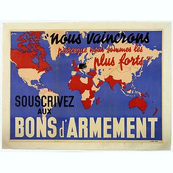
Nous vaincrons parce que nous sommes les plus forts. Souscrivez aux bons d'armement.
"We win because we are the strongest. Support good armaments". Quote by the French Prime Minister Paul Reynaud. French wartime propaganda poster. color printed ...
Date: Paris, M.Dechaux, ca 1939
Selling price: ????
Please login to see price!
Sold in 2019
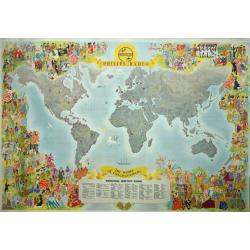
Philips Radio The World of Entertainment.
A decorative, spectacular and rare Philips Radio pictorial promotional world map that features the locations of dozens of global shortwave stations. Design by Ensak.The s...
Date: Rotterdam, Kuhn en zoon, ca. 1940
Selling price: ????
Please login to see price!
Sold in 2020

Ross indipendet Oil Co., Canton, O. War map of the World.
World map showing the world during World War II. With a color key lower left to the different powers and bases for American, British, Dutch Russian and Other defense armi...
Date: Erie, ca. 1942
Selling price: ????
Please login to see price!
Sold in 2012
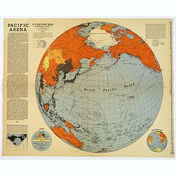
Pacific Arena
A brightly colored second world war map covering the Pacific regions. Printed as Supplements to 'Fortune' in March 1942. This informative Pacific map comes with a good de...
Date: New York, 1942

Dated Events War Map furnished you the compliments of United Air Lines.
Decorative large format colorful map of the world. Inset maps of the Philippines, Japan and Germany and to the left and right a list of events happened in Europe and the ...
Date: Canada, 1942
Selling price: ????
Please login to see price!
Sold in 2021
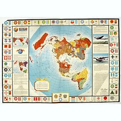
Global Map for Global War and Global Peace.
Map border has aircraft insignia for nations of the world, a table of air lines distances (worldwide), illustrations of the "flying boat" and a bomber, and map ...
Date: New York, 1943
Selling price: ????
Please login to see price!
Sold in 2016
![America's Worldwide War [with] American troops. . .](/uploads/cache/39803-250x250.jpg)
America's Worldwide War [with] American troops. . .
Two World maps centered on the Americas. The top map with a text underneath : America's Worldwide War is illustrated by this map based on the Marshall report ... The lowe...
Date: New York , Time Magazine, 1943
Selling price: ????
Please login to see price!
Sold in 2017
Les Ailes Française à travers le Monde - Raids et exploits.
Very large pictorial world map signed "Troy 43" and created for "The Air Minister". The French Air Ministry was created by decree in 1928. The prime m...
Date: Paris, 1943
Selling price: ????
Please login to see price!
Sold in 2019
![[GEOGRAPHICAL BOARD GAME] Die Große Weltreise.](/uploads/cache/40270-250x250.jpg)
[GEOGRAPHICAL BOARD GAME] Die Große Weltreise.
A rare post WW II geographical game, made in 1947 by the Flemming publishing house. The player has to travel around the world in 60 steps. The map, although extremely tas...
Date: Hamburg, June 1947
Selling price: ????
Please login to see price!
Sold in 2017
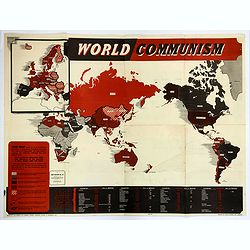
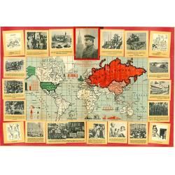
World Communism.
Map Review No. 40. A large folding World map showing all the nations of the world. Each country is shaded differently to reflect where Communism is in power, where Commun...
Date: London, ca 1947
Selling price: ????
Please login to see price!
Sold in 2018
AIR France - Réseau Aérien Mondial.
"Réseau Aérien Mondial" original pictorial color lithographed advertising planisphere poster from AIR France. The poster has a black back ground. In the lower...
Date: Imprimerie Perceval, Paris, ca. 1948
Selling price: ????
Please login to see price!
Sold in 2023
AIR France - Réseau Aérien Mondial.
"Réseau Aérien Mondial" original pictorial lithograph advertising planisphere poster from AIR France. The poster has a black back ground. In the lower right b...
Date: Paris, ca. 1948
Selling price: ????
Please login to see price!
Sold in 2020
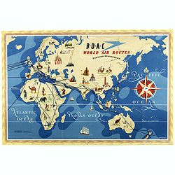
World Air Routes: Eastern Hemisphere / B.O.A.C. - World Air Routes: Western Hemisphere.
Original Vintage pictorial map of the Eastern Hemisphere issued by B.O.A.C. Artwork by E.O.Seymour. On the verso, the western hemisphere.The map was issued as a folding m...
Date: Great Britain, 1949
Selling price: ????
Please login to see price!
Sold in 2018
Bold World Map for the 70th anniversary of Joszif Visszarionovics STALIN.
Extremely rare, separately, only once issued, so called "placard / poster" economical world map! Surrounded by the portrait of "the big and genius leader ...
Date: Budapest, 1949
Selling price: ????
Please login to see price!
Sold in 2019
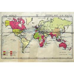
The World Ocean and Air Routes.
An interesting school map of the World illustrating the air and sea routes. The coloring shows the colonial powers. From Gill's Simplified Wall Map Series.
Date: London, ca. 1950
Selling price: ????
Please login to see price!
Sold in 2018
Réseau aérien mondial.
"Sur les ailes d'Air France, découvrez le monde à votre tour" advertising lithograph poster from AIR France, the French airline company. The poster has always...
Date: Imprimerie Perceval Paris, ca. 1940-1950
Selling price: ????
Please login to see price!
Sold
Planisphéres terrestes. Quelques voyages récents de batiments de guerre.
Stunning world map by Hervé Baille published in Paris in 1950 at G. Barbarin & Cie. The map focuses on the routes and travel of explorer like La Perouse, Beautemps-B...
Date: G. Barbarin & Cie, Paris, 1950
Selling price: ????
Please login to see price!
Sold in 2020
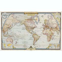
The World Map.
World map centered on North America, with inset maps of North and South Poles. The first issue of National Geographic Magazine was published on September 22, 1888, nine m...
Date: Washington, 1951
Selling price: ????
Please login to see price!
Sold in 2023
![[World Map].](/uploads/cache/42059-250x250.jpg)
[World Map].
color printed pictorial world map, with decorative title cartouche and borders, depict continents, mores and wildlife. Includes decorative compass rose. Published by Ode ...
Date: Paris, 1951
Selling price: ????
Please login to see price!
Sold in 2018
AIR France - Sur les ailes d'Air France découvrez le monde à votre tour.
Promotional poster of a double hemisphere world map designed by Lucien Boucher for AIR France. The map depicts the entire world in rich blues and burgundies with gold hig...
Date: Perceval, Paris, 1952
Selling price: ????
Please login to see price!
Sold in 2020
AIR France - Sur les ailes d'Air France découvrez le monde à votre tour.
Promotional poster of a double hemisphere world map designed by Lucien Boucher for AIR France. The map depicts the entire world in rich blues and burgundies with gold hig...
Date: Perceval, Paris, 1952
Selling price: ????
Please login to see price!
Sold in 2023
![Air France [poster].](/uploads/cache/43987-250x250.jpg)
Air France [poster].
A superb double sided Air France folding poster, featuring bold colored graphics. Published as a serious piece of marketing put out by the airline showing off their state...
Date: Paris, 1955
Selling price: ????
Please login to see price!
Sold in 2019
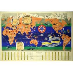
Le Tour du Monde en 120 Images Grand Concours du Chocolat Menier.
A splendid pictorial map of the world by Chocolat Menier. The map features 120 images of explorers, plants, animals, and structures from around the world.Three small inse...
Date: Paris, 1956
Selling price: ????
Please login to see price!
Sold in 2020
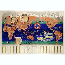
Le tour du monde en 120 images, grand concours du Chocolat Menier.
Pictorial map of the world by Chocolate Menier. The map features 120 images of explorers, plants, animals, and structures from around the world. Three small inserts prese...
Date: Paris, 1956
Selling price: ????
Please login to see price!
Sold in 2017
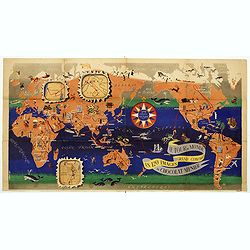
Le Tour du Monde du Monde en 120 images grand concours du Chocolat Menier.
Wonderful advertisement world map in Mercator projection drawn by J. B. Jannot and issued to promote Chocolat Menier with several insets of Tibet, Israel, Congo Belge.The...
Date: Paris, Chocolat Menier, 1956
Selling price: ????
Please login to see price!
Sold in 2020
Le Tour du Monde en 120 Images Grand Concours du Chocolat Menier.
This highly unusual and rather novel pictorial map of the world was created by J.B. Jannot.
Date: Paris, 1956
Selling price: ????
Please login to see price!
Sold in 2020
Grand circuit des capitales. Offert par le chocolat Menier.
A very decorative pictorial map of Europe and Asia, made for Chocolat Menier by J.B. Jannot (signed as Jan Loup) showing the capital cities of various countries published...
Date: Paris, 1956
Selling price: ????
Please login to see price!
Sold in 2020
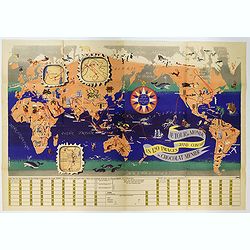
Le Tour du Monde en 120 Images Grand Concours du Chocolat Menier.
This highly unusual and rather novel pictorial map of the world was created by J.B. Jannot and published by Agence Française de Propagande as a promotional item for Meni...
Date: Paris, 1956
Selling price: ????
Please login to see price!
Sold in 2022
![[WORLD GLOBE]](/uploads/cache/44300-250x250.jpg)
[WORLD GLOBE]
A highly unusual and fascinating folding paper globe of the world, produced in The Netherlands in the late 1950s. You can 'turn' the globe over to reveal another section ...
Date: Zwolle, 1957
Selling price: ????
Please login to see price!
Sold in 2021
AIR France - Le plus grand réseau du monde.
Created in 1959 by the artist Lucien Boucher, showing all of the DC-7 Air France Routes. The Blue Pink Poster is one of a series of eight posters commissioned by Air Fran...
Date: Imprimerie Perceval, Paris, 1959
Selling price: ????
Please login to see price!
Sold in 2020
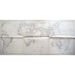
Atlantic and Indian Oceans with the western portion of Pacific Ocean...
Scarce and very large sea-chart extending from North America to New Zealand, including all of South America, Africa, South-East Asia, Australia, etc. With a wealth of det...
Date: London, 1960
Selling price: ????
Please login to see price!
Sold in 2014
![[TAI travel poster]](/uploads/cache/41534-250x250.jpg)
[TAI travel poster]
A whimsical travel poster for "Transport Aeriens Intercontinentaux" (TAI), published in Paris in 1960, by Luc-Marie Bayle (1914-2000). The poster depicts a twin...
Date: Paris, 1960
Selling price: ????
Please login to see price!
Sold in 2018
![[TAI travel poster]](/uploads/cache/45013-250x250.jpg)
[TAI travel poster]
A whimsical travel poster for "Transport Aeriens Intercontinentaux" (TAI), published in Paris in 1960, by Luc-Marie Bayle (1914-2000). The poster depicts a twin...
Date: Paris, 1960
Selling price: ????
Please login to see price!
Sold in 2019
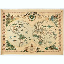
Outspan dans le monde. Carte illustrée des exportations d'agrumes Outspan dans le monde.
Double hemisphere, with pictorial details and illustrations, plus several countries flags in the left and right sides. Showing Outspan citron exportations all around the ...
Date: France, ca. 1960
Selling price: ????
Please login to see price!
Sold in 2021
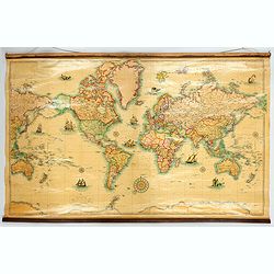
Planisphere Terrestre. . .
A striking large and colorful wall map of the World on Mercator's Projection, by Bereglin, produced by Girard and Barrere in Paris. The map is beautifully presented, and ...
Date: Paris, 1960
Selling price: ????
Please login to see price!
Sold in 2022
World map with zodiac figures.
AIR FRANCE poster by Lucien Boucher (1889 - 1971) showing a globe on a blue back ground showing zodiac figures. Printed by Imprimerie Perceval, Paris.This very rare and b...
Date: Imprimerie Perceval Paris, ca. 1962
Selling price: ????
Please login to see price!
Sold in 2018
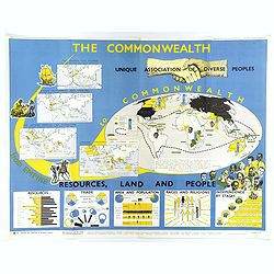
The Commonwealth Unique Association of Diverse Peoples.
An elliptical world map highlighting in yellow and in green both 'Independent Commonwealth Countries' and 'Dependent Commonwealth Countries' around the globe. Each contin...
Date: London, 1963
Selling price: ????
Please login to see price!
Sold in 2018
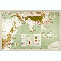
Main areas of tea production.
A map of the eastern hemisphere showing the main areas of tea production. With in lower part inset "Ceylon - Home of good tea. With reference color key.
Date: London, 1963
Selling price: ????
Please login to see price!
Sold in 2021
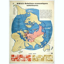
U.R.S.S. Relations économiques extérieures. (7)
World map centred on Russia. Propaganda poster for Russia's in and export of industrial goods. With a numbered key (1-30). Editions de l'Agence de presse Novosti".Mo...
Date: USSR, 1978
Selling price: ????
Please login to see price!
Sold in 2017
