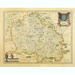
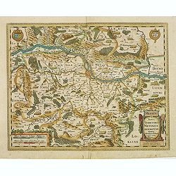
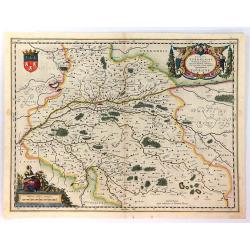
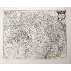
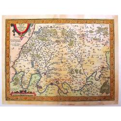
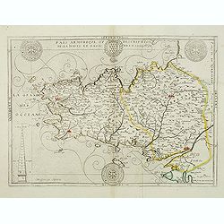
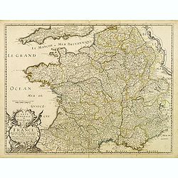
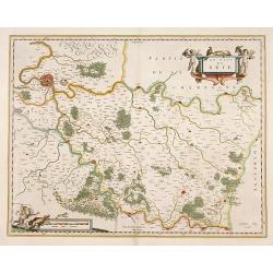
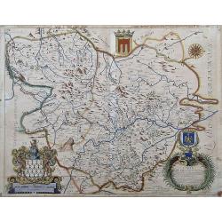
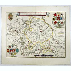
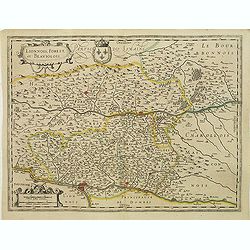
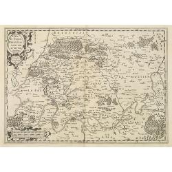
BORBONIUM Ducatus BOURBONNOIS.
Decorative map of the area called Bourbonnais. In the Top left-hand corner, a big cartouche with title and coast of arms. In the opposite corner, a smaller cartouche with...
Date: Amsterdam, 1635
Selling price: ????
Please login to see price!
Sold in 2009
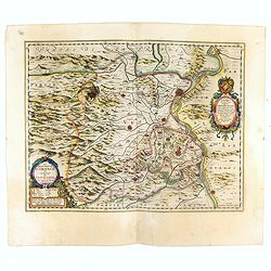
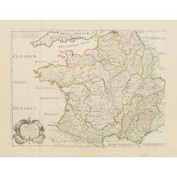
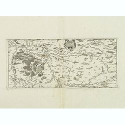
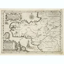
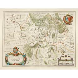
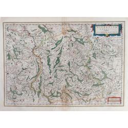
La Principaute d\' Orange et Comtat de Venaissin Par Iaques se Chieze Oraqngeois. 1627.
Willem Blaeu was the founder of the famous publishing firm. Johan succeeded his father when the latter died in 1638. He led the Blaeu firm to its greatest achievement the...
Date: Amsterdam, 1635
Selling price: ????
Please login to see price!
Sold in 2009
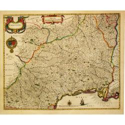
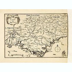
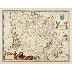
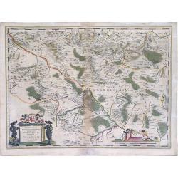
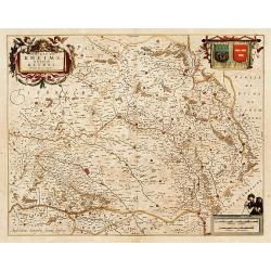
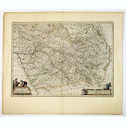
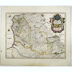
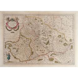
Languedoc.
Willem Blaeu was the founder of the famous publishing firm. Johan succeeded his father when the latter died in 1638. He led the Blaeu firm to its greatest achievement the...
Date: Amsterdam, 1635
Selling price: ????
Please login to see price!
Sold in 2017
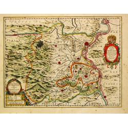
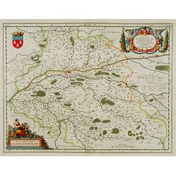
La Principauté d'ORANGE et Comtat de VENAISSIN. Par Jacques de Chieze.
A beautiful map of Orange and Avignon, decorated with finely engraved title cartouches. South to the top. Lower right early signature of Willem Blaeu: Guiljelmus Janssoni...
Date: Amsterdam , ca. 1635
Selling price: ????
Please login to see price!
Sold in 2022
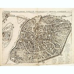
Civitatis avenionis omnimq viarum et aedifciorum eius perfecta delineatio.
Early plan of Avignon by Mathias Merian.
Date: Paris, 1635
Selling price: ????
Please login to see price!
Sold in 2012
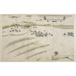
Pourtraict de la fameuse ville et havre de Duynckercke. . .
Detailed of the coast of France from Dunkerque to Calais showing fleets anchored offshore. With an inset panorama of Duynckercke [Dunkirk] after Jan Van Loon and a small...
Date: Amsterdam, 1635
Selling price: ????
Please login to see price!
Sold in 2021
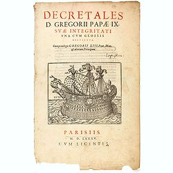
(Title page) Decretales D. Gregorii Papæ IX. Suæ integritati una cum glossis restitutæ.
Decorative title page from "Corpus iuris canonici). Decretum Gratiani. Emendatum et notationibus illustratum. Una cum glossis Gregorii XIII. Pont. Max. iussu ed. Ad ...
Date: Paris, 1635
Selling price: ????
Please login to see price!
Sold in 2020
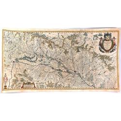
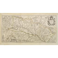
MESSIN. Nova Territorii Metensis Descriptio Autore Abrahamo Fabert Consule Urbis Metensis.
A finely engraved map centered on Metz in France. The author of this map was the French printer Abraham Fabert (1560-1638).No text on verso. From a French composite atlas...
Date: Amsterdam, ca. 1635
Selling price: ????
Please login to see price!
Sold
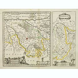
Loudunois. Laudunum / Mirebalais.
Two maps on one sheet. Centered on Loudun and Mirebeau. Showing lower left cartouche putti playing with grapes.No text on verso. From a French composite atlas.Read more a...
Date: Amsterdam, after 1636
Selling price: ????
Please login to see price!
Sold
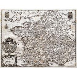
Gallia. Le Royaume de France. Franckreych.
Merian's very decorative and detailed map of France and Switzerland. Richly embellished with coats of arms, a compass rose, and the title cartouche.
Date: Frankfurt, ca. 1636
Selling price: ????
Please login to see price!
Sold in 2016
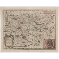
Perchensis Comitatus, La Perche Compte Amstlelodami.
A highly detailed 1636 Jansson map of the former province of Perche, France. It features a strap work title cartouche, a drape including a large Royal armorial and a str...
Date: Amsterdam, 1636
Selling price: ????
Please login to see price!
Sold in 2023
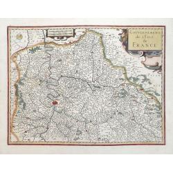
Gouvernement de L\'Isle de France.
Attractive map of Paris and its environs published in the rare English edition of Mercator's Atlas published by Henricus Hondius and Jan Jansson in 1636. This map is in ...
Date: Amsterdam, 1636
Selling price: ????
Please login to see price!
Sold in 2013
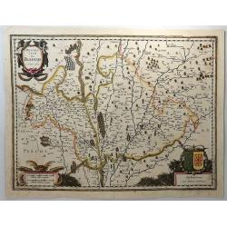
Description de Blaisois.
This antique engraved map originates from a rare two volume Hondius / Janssonius Atlas: Atlas, das ist, Abbildung der Gantzen Welt ..... The Blésois is a French natural ...
Date: Amsterdam, 1636
Selling price: ????
Please login to see price!
Sold in 2018
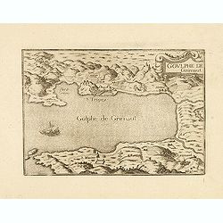
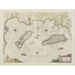
Goulphe de Grimaut.
Bay of St. Tropez. Published by Nicolas Tassin in "Les Plans et Profilz de toutes principalles Villes et lieux considerable de France." The first edition of thi...
Date: Paris, Sébastien Cramoisy, 1636
Selling price: ????
Please login to see price!
Sold
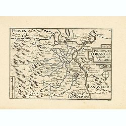
Principauté d'Oranges & comtat de Venaissin.
Published by Nicolas Tassin in "Les Plans et Profilz de toutes principalles Villes et lieux considerable de France." The first edition of this work was publishe...
Date: Paris, Sébastien Cramoisy, 1636
Selling price: ????
Please login to see price!
Sold in 2013
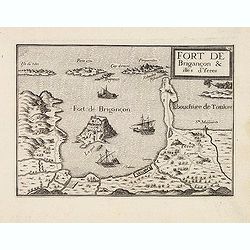
Fort de Brigançon & isles d'Yeres
Published by Nicolas Tassin in "Les Plans et Profilz de toutes principalles Villes et lieux considerable de France." The first edition of this work was publishe...
Date: Paris, Sébastien Cramoisy, 1636
Selling price: ????
Please login to see price!
Sold
Carte de Provence.
Topographically detailed map of the region of Provence in south-eastern France. Relief shown pictorially. Published by Nicolas Tassin in "Les Plans et Profilz de tou...
Date: Paris, Sébastien Cramoisy, 1636
Selling price: ????
Please login to see price!
Sold in 2012
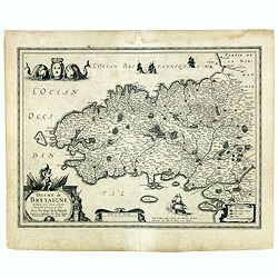
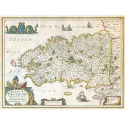
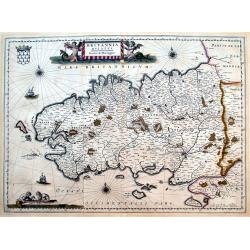
Duche de Bretaigne Designé par le Sieur Hardy Mareschal des logis du Roy. . .
Detailed map of Bretagne in a first state. Here with the double signature of Hondius and Tavernier. After 1636 the signature of Hondius was replaced by Janssonius and sig...
Date: Amsterdam/ Paris, ca. 1630-1636
Selling price: ????
Please login to see price!
Sold
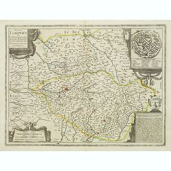
Totius Lemovici (Limoges)
Decorative map of the region of Limoges, with in the corner a city plan of Limoges, and cartouches in the other corners.From a French composite atlas. Read more about Dut...
Date: Amsterdam, after 1636
Selling price: ????
Please login to see price!
Sold
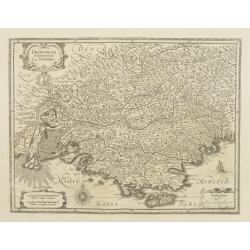
Provincia. La Provence.
Detailed map of the Province including the towns of Marseille, Avignon, Nice, Aix-en-Provence, Sisteron, etc.
Date: Amsterdam, 1636
Selling price: ????
Please login to see price!
Sold
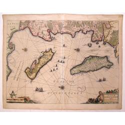
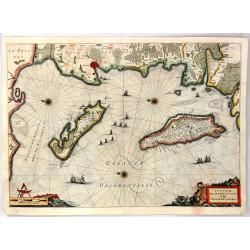
Insulae Divi Martini et Uliarus Vulgo L'Isle de Re et Oleron.
Detailed chart if Ile de Re and Ile d'Oleron with the coast line around La Rochelle. North is oriented to the left instead of up. Decorative title cartouche with a putti ...
Date: Amsterdam, 1636
Selling price: ????
Please login to see price!
Sold in 2016
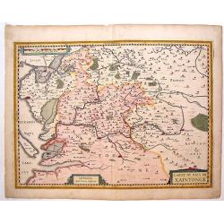
Carte du Pais de Xaintonage.
Copper engraved map of Saintonge, France showing cities such as La Rochelle, Pons, Marans, etc. Two striking title cartouches with cities depicted in detail as miniature ...
Date: Amsterdam, 1636
Selling price: ????
Please login to see price!
Sold in 2015
![Chav dif [château d'if ]](/uploads/cache/32742-250x250.jpg)
Chav dif [château d'if ]
Early map of the island of If with Château d'If. The Château d'If is a fortress (later a prison). The island of If, the smallest island in the Frioul Archipelago situat...
Date: Paris, Sébastien Cramoisy, 1636
Selling price: ????
Please login to see price!
Sold in 2012
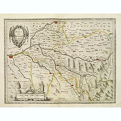
Le Pais de Bearn. Avec Privilege du Roy.
Map of the south west of France centered on Orthes. Map shows Bayonne, bidache, Pontac, Oleron. . . embellished by a beautiful title cartouche and a beautiful scale carto...
Date: Amsterdam, after 1636
Selling price: ????
Please login to see price!
Sold in 2012
La Principaute D'Orange et combat de Venaissin.
Very decorative copper engraved map featuring the cities of Avignon and Orange, as well as several smaller villages. The mountainous and forested topography is graphicall...
Date: Amsterdam, 1637
Selling price: ????
Please login to see price!
Sold
Duche de Bretagne.
Janssonius' Brittany map.
Date: Amsterdam, 1637
Selling price: ????
Please login to see price!
Sold in 2009
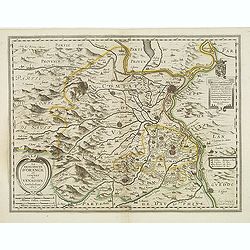
Ducatus Turonensis....
Lovely decorative map of the Touraine region of France with Tours and the Loire River at center. Two decorative cartouches feature allegorical renderings of Mother Earth ...
Date: Amsterdam, ca. 1638
Selling price: ????
Please login to see price!
Sold in 2018
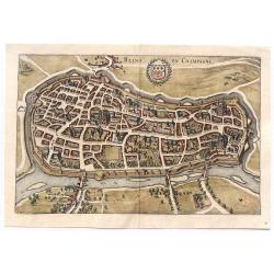
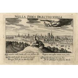
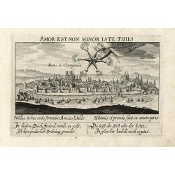
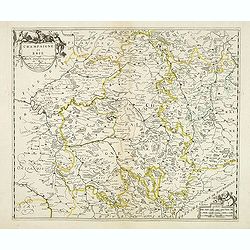
Reims en Champagne.
Striking birdseye view of Reims in Champagne, from Merian's “Neuwe Archontologica Cosmica”, published in 1638. It shows the detailed town plan of Reims and Champagne,...
Date: Frankfurt, 1638
Selling price: ????
Please login to see price!
Sold in 2018
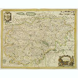
Comitatus Burgundiae.
Detailed map showing Burgundy, with decorative cartouches. No text on verso. From a French composite atlas.
Date: Amsterdam, c.1639
Selling price: ????
Please login to see price!
Sold
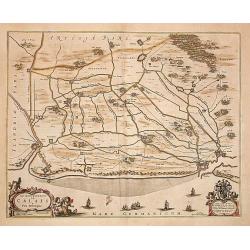
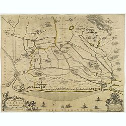
Le gouvernement de Calais & Païs reconquis.
An attractive map of the north-western part of France including the towns of Calais, Gravelines. South to the top.
Date: Amsterdam 1640
Selling price: ????
Please login to see price!
Sold
Belsia, Vulgo La Beausse.
In the left-hand lower part of the image a beautiful contemporary colored cartouche with goddess Ceres [agricultural] holding a reaping-hook in her right hand and receivi...
Date: Amsterdam, 1640
Selling price: ????
Please login to see price!
Sold in 2011
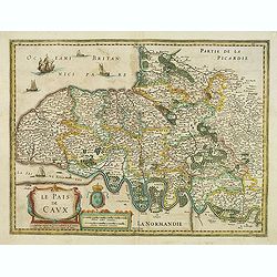
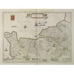
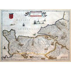
Le Pais de Caux.
Detailed map of Normandy. Map centered on Rouen, and shows Honfleur, Le Havre, St Vallery, Dieppe. . .Embellished with a beautiful cartouche, and a sailing ship.No text o...
Date: Amsterdam/ Paris, 1640
Selling price: ????
Please login to see price!
Sold
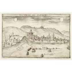
La Ville de Fovgers.
Charming view of Fougères, in Brittany.
Date: Paris, ca. 1640
Selling price: ????
Please login to see price!
Sold
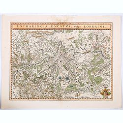
Lotharingia Ducatus vulgo Lorraine.
A very detailed map for his time centered on Nancy, Bayon and Metz, and including the river valleys of the Sar and Moselle. In the lower right-hand corner of the map is a...
Date: Amsterdam, ca 1640
Selling price: ????
Please login to see price!
Sold in 2021
-250x250.jpg)
Antiquorum Galliae Episcopatuum...
Rare map of ancient France, including Switzerland and the Low Countries. With a large decorative title cartouche. Includes a large inset map of the British Isles.
Date: Paris, 1640
Selling price: ????
Please login to see price!
Sold in 2023
Alsatia Landgraviatus, cum Suntgoia et Brisgoia,. .
A large, detailed, and handsome map of Alsace, a famous wine region of France, based on the work of Gerard Mercator. It covers the region including the Rhine from Granvil...
Date: Amsterdam, 1640
Selling price: ????
Please login to see price!
Sold in 2016
Provincia. La Provence.
Detailed map of the Province including the towns of Marseille, Avignon, Nice, Aix-en-Provence, Sisteron, Cannes, St. Tropez, Toulon, etc. Three decorative cartouches, coa...
Date: Amsterdam, 1640
Selling price: ????
Please login to see price!
Sold in 2014
Normandia Ducatus.
Very detailed map of Normandy centered on Caen and Rouen. Also showing Cherbourg, Avranches, Bayeux, Cabourg, Honfleur, Le Havre, Etretat, Fecamp. St Malo and Mont Saint ...
Date: Amsterdam, 1640
Selling price: ????
Please login to see price!
Sold
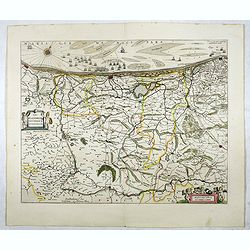
Diocese de Rheims, et le pais de Rethel...
Attractive map of the department in the Champagne-Ardenne region of France. Centred on Reims city. Many towns, forests, and waterways are identified. Decorated with the b...
Date: Amsterdam, ca. 1640
Selling price: ????
Please login to see price!
Sold in 2016
Les environs de L'Estang de Longpendv, Comprenant une grande partie du Comte de Charolois.
Beautiful map showing the lands of the Duke of Charolais in the region of France west of Chalon-sur-Saône, between Dijon and Lyon in France, published by the Blaeu firm....
Date: Amsterdam, c.1640
Selling price: ????
Please login to see price!
Sold in 2010
Gallia Antiqua.
A fine map of ancient France.This edition carries the date 1641.Nicolas Sanson was to bring about the rise of French cartography, although the fierce competition of the D...
Date: Paris 1641
Selling price: ????
Please login to see price!
Sold
Gallia Antiquae Descriptio, Geographica. . .
An attractive map of ancient Gaul (present day France and Belgium) by the French cartographer Nicolas Sanson, and published by Pierre Mariette. A decorative title cartouc...
Date: Paris, 1641
Selling price: ????
Please login to see price!
Sold in 2010
l'isle de France, Parisiensis Agri de Script.
An attractive map that depicts the region surrounding Paris. There are strap-work title and scale cartouches and a beautiful interlocking border. The high detail depicts ...
Date: Antwerp, 1641
Selling price: ????
Please login to see price!
Sold in 2016
Carte des environs de la Ferre.
Detailed map of the north of France, of the region of Picardie. Prepared by Claude de Chastillon (1559-1616) and published by Jean Boisseau. Map shows Folembrai, La ferre...
Date: Paris, 1642
Selling price: ????
Please login to see price!
Sold
Britannia Ducatus. Duche de Bretaigne.
Early map of Bretagne. Highly detailed, filled with place names. Includes Mont-Saint-Michel, Ile Ouessant, Belle-Ile, and Noirmoutier. Richly decorated with a title carto...
Date: Amsterdam, 1642
Selling price: ????
Please login to see price!
Sold in 2016
Normandia ducatus.
Very detailed map of Normandy centered on Caen and Rouen. Also showing Cherbourg, Avranches, Bayeux, Cabourg, Honfleur, Le Havre, Etretat, Fecamp. St Malo and Mont Saint ...
Date: Amsterdam, 1642
Selling price: ????
Please login to see price!
Sold in 2016
Païs armorique, ou Description de la haute et basse Bretagne, 1642.
Beautiful and rare map of Bretagne published by Boisseau, this edition is without text on the back. Boisseau used the copperplate by Bouguereau. The plate was included in...
Date: Paris, after 1642
Selling price: ????
Please login to see price!
Sold
Troye
Wonderful, miniature copper engraving of Troye. There is a Latin title at top and the text below the print is in Latin and German. The city of Troye is shown in the backg...
Date: Frankfurt, ca.1642
Selling price: ????
Please login to see price!
Sold in 2014

Metz
Wonderful, miniature copper engraving of Metz. There is a Latin title at top and the text below the print is in Latin and German. The city of Metz is shown in the backgro...
Date: Frankfurt, ca.1642
Selling price: ????
Please login to see price!
Sold in 2014
Orleans
Wonderful, miniature copper engraving of Orleans. There is a Latin title at top and the text below the print is in Latin and German. The city of Orleans is shown in the b...
Date: Frankfurt, ca.1642
Selling price: ????
Please login to see price!
Sold in 2014
Reims
Wonderful, miniature copper engraving of Reims. There is a Latin title at top and the text below the print is in Latin and German. The city of Reims is shown in the backg...
Date: Frankfurt, ca.1642
Selling price: ????
Please login to see price!
Sold in 2014
Carte générale du Royaume de France..
This beautifully engraved map depicts France as known in the mid 17th century. Topographical features are shown and major cities, towns, waterways, mountains and islands ...
Date: Paris, 1643
Selling price: ????
Please login to see price!
Sold in 2014
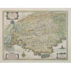
Provincia Britanniae Armoricae Cum confiniis.
Map of the Brittany region in France, published in the rare atlas "Capucins de Rome".
Date: Rome, 1643
Selling price: ????
Please login to see price!
Sold in 2014
Profil de la Ville Archiepiscopal de Tours Appellee Vulgairement le Jardin de la France, 1643.
Hand-colored copperplate engraving featuring a panoramic view of Tours engraved by the famous master engraver, Hugues Picart (1587-1662). This view is extremely detailed ...
Date: Paris, 1643
Selling price: ????
Please login to see price!
Sold in 2018
Le gouvernement de Calais & Païs reconquis.
An attractive map of the north-western part of France including the towns of Calais, Gravelines. South to the top. Dedication to Cornelis de Glarges.No text on verso. Fro...
Date: Amsterdam, ca. 1644
Selling price: ????
Please login to see price!
Sold in 2013
Le Pais de Brie.
A very decorative map with beautiful cartouches of a province of France by one of the most famous map publishers.
Date: Amsterdam 1645
Selling price: ????
Please login to see price!
Sold
Les Souverainetez de Sedan et de Raucourt.. Doncheri.
A very decorative map with beautiful cartouches of a province of France by one of the most famous map publishers.
Date: Amsterdam 1645
Selling price: ????
Please login to see price!
Sold
Dioecese de Rheims, et le païs de Rethel.
A very decorative map with beautiful cartouches of a province of France by one of the most famous map publishers.
Date: Amsterdam 1645
Selling price: ????
Please login to see price!
Sold
Ducatus Turonensis.. Touraine.
A very decorative map with beautiful cartouches of a province of France by one of the most famous map publishers. Including the River Loire Valley with the towns of Tours...
Date: Amsterdam 1645
Selling price: ????
Please login to see price!
Sold
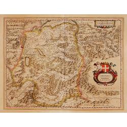
Sabaudia Ducatus. Savoye.
A very decorative map with beautiful cartouches of Savoie by one of the most famous map publishers. Showing Geneva and the Leman Lake on top of the map and Grenoble in th...
Date: Amsterdam 1645
Selling price: ????
Please login to see price!
Sold
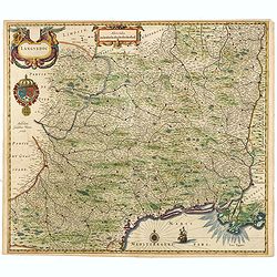
Languedoc.
Embellished with decorative and scale cartouches, double coat of arms, compass rose and ship.
Date: Amsterdam, 1645
Selling price: ????
Please login to see price!
Sold in 2015
Carte du Pais d'Auvergne.
Map of the Auvergne countryside. Dedicated to the high and powerful seig.r Gaspar de Coligny ... Bottom rightquadrant title and dedication in a cartouche decorated with t...
Date: Paris, 1645
Selling price: ????
Please login to see price!
Sold in 2020
Alsatia Landgraviatus cum Suntgoia et Brisgoia.
Large map of Alsace based on the work of Gerard Mercator. Covers the region including the Rhine from Granville to Sarburg in the north and from Basel to Landaw in the sou...
Date: Amsterdam, 1645
Selling price: ????
Please login to see price!
Sold in 2018
Insulae Divi Martini et Viliarus Vulgo L'Isle de Re et Oleron.
A very decorative map in the islands of Ré and Oléron, off the Atlantic coast of France. It includes a title cartouche decorated with mermaids and a scale cartouche wit...
Date: Amsterdam, 1645
Selling price: ????
Please login to see price!
Sold in 2016
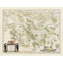
Champagne et Brie. Par Mr. Sanson geographe du Roy. . .
Early imprint of this fine map of the Champagne-Ardenne area, embellished with decorative title cartouche and scale cartouche with putti and surveying instruments. Paris,...
Date: Paris, ca. 1645
Selling price: ????
Please login to see price!
Sold in 2012
Pars Flandriae Teutonicae Occidentalior.
The western part of Teutonic Flanders, spreading from Nieuwpoort to Gravelines, follows the 'Flandriae Teutonicae Pars Orientalior'.More about maps by Willem Blaeu. [+]
Date: Amsterdam, 1645
Selling price: ????
Please login to see price!
Sold in 2020
Les environs de L'Estang de Longpendu,.. Charolois.
A very decorative map with beautiful cartouches of Charolois in the Bourgogne by one of the most famous map publishers.
Date: Amsterdam, 1645
Selling price: ????
Please login to see price!
Sold in 2017
Galloflandria, in qua Castellaniae Lilana, Duacena, & Orchiesia, cum dependentibus, necnon Tornacum, & Tornacesium. Auctore Martino Doue Gallo-Flandro.
Map of French Flanders. More about maps by Willem Blaeu. [+]
Date: Amsterdam, 1645
Selling price: ????
Please login to see price!
Sold in 2017
Alsatia Landgraviatus cum Suntgoia et Brisgoia
Large map of Alsace based on the work of Gerard Mercator. Covers the region including the Rhine from Granville to Sarburg in the north and from Basel to Landaw in the sou...
Date: Amsterdam 1645
Selling price: ????
Please login to see price!
Sold
![[Set of 11 maps of different regions of France]](/uploads/cache/43028-250x250.jpg)
[Set of 11 maps of different regions of France]
Set of 11 maps of different regions of France:- Gouvernement general du Lyonnois ( 410mm x 580mm)- Diocese de Rheims . . . ( 410mm x 520mm)- Gouvernement de la Cappelle (...
Date: Amsterdam, ca. 1645
Selling price: ????
Please login to see price!
Sold in 2020
Senonois, & La Partie Meridionale de la Champagne.
A beautiful mid seventeenth-century map of Senonois and the southern region of Champagne in northern France. The region of Champagne, lying to the east of Paris, is one o...
Date: Amsterdam, ca 1645
Selling price: ????
Please login to see price!
Sold in 2021
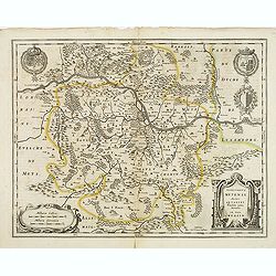
Territorium Metense.
A finely engraved map centered on Metz in France. Cartouche decorated with a chain of leaves and fruits and three coats of arms.The author of this map was the French prin...
Date: Amsterdam, 1645
Selling price: ????
Please login to see price!
Sold
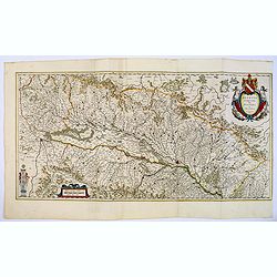
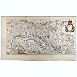
Lionnois, Forest, Beaujolois et Masconnois.
Map of a province of France including the rivers Rhone and Loire north of Lyon.The first state before the signature of Johannes Janssonius was added. No text on verso. Fr...
Date: Amsterdam, c. 1631 and before 1645
Selling price: ????
Please login to see price!
Sold
Artesia Comitatus. Artois.
Very decorative map of north-western part of France.As Willem Blaeu died in 1638 most of his maps are actually published by his son Joan.More about maps by Willem Blaeu. ...
Date: Amsterdam, 1645
Selling price: ????
Please login to see price!
Sold in 2017
Insulae divi Martini et Uliarus, Vulgo l' Isle de Ré et Oléron.
Map of Ré and Oléron islands. Depicting the west coast of France, showing La Rochelle. Several vessels and sailing ships dot the Atlantic ocean.Three wind roses indicat...
Date: Amsterdam, 1645
Selling price: ????
Please login to see price!
Sold in 2015
Alsatia Landgraviatus cum Suntgoia et Brisgoia.
Large map of Alsace based on the work of Gerard Mercator. Covers the region including the Rhine from Granville to Sarburg in the north and from Basel to Landaw in the sou...
Date: Amsterdam, 1645
Selling price: ????
Please login to see price!
Sold in 2018
L'isle de France. Parisiensis Agri descriptio.
Map of Ile d'France with Paris, the river Seine and the town north of Paris, showing Pontoise, Meaux, Senlis, Meudon.The map was prepared by François de la Guillotière,...
Date: Amsterdam, 1645
Selling price: ????
Please login to see price!
Sold
Nivernium Ducatus Gallice Duche de Nevers.
Blaeu map of central France showing, on the east side, the city of Bourges, and to the west, the city of Autun.
Date: Amsterdam, 1645
Selling price: ????
Please login to see price!
Sold in 2010
Comitatus Bellovacum Vernacule Beauvais.
Bleau map of northern central France region, showing area just north of Paris.
Date: Amsterdam, 1645
Selling price: ????
Please login to see price!
Sold in 2010

Typus Galliae Veteris, Ex conatib' Geograph. Abrah.Ortelii.
A very decorative map with countries of ancient France prepared by Abraham Ortelius and published by one of the most famous map publishers, Willem Blaeu.
Date: Amsterdam, 1645
Selling price: ????
Please login to see price!
Sold in 2026
