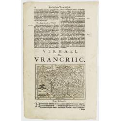
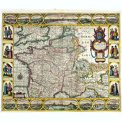
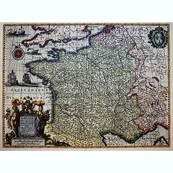
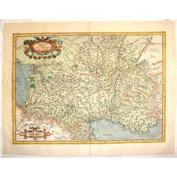
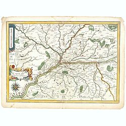
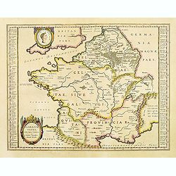
Gallia.
Small map of France, surrounded by text in Dutch. Nicolaes de Clerck (de Klerc) was active as engraver and publisher in Delft from 1599-1621.Included in the rare book : W...
Date: Amsterdam, Cloppenburch, 1621
Selling price: ????
Please login to see price!
Sold
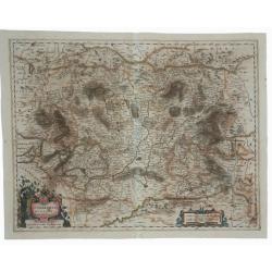
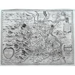
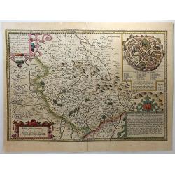
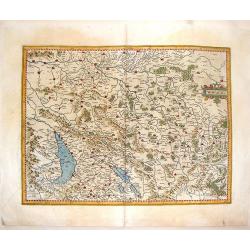
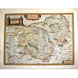
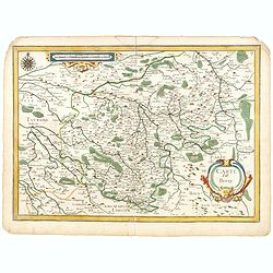
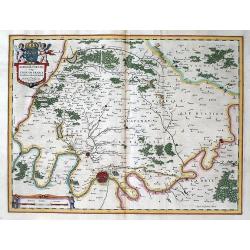
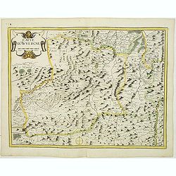
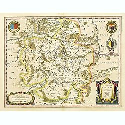
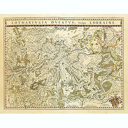
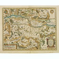
Otharingia Ducatus Noua Deseriptio.
An old, antique map of Lorraine, by Johannes Janssonius. It features a decorative cartouche and mileage chart. Johannes Janssonius (Arnhem, 1588-1664), son of the Arnhem ...
Date: Amsterdam, 1623
Selling price: ????
Please login to see price!
Sold in 2020
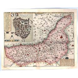
Descrition Du Diocese de Sarlat et Haut Perigord.
A delicate and detailed map of the Dordogne region of France, including Sarlat, Bergerac, and Domme. The map features an insert of Sarlat, with 23 points listed and numbe...
Date: Paris, 1624
Selling price: ????
Please login to see price!
Sold in 2018
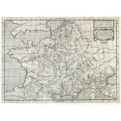
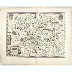
Notitia Chorographica Episcopatuum Galliae.
Historical map of France.
Date: Paris, 1625
Selling price: ????
Please login to see price!
Sold in 2009
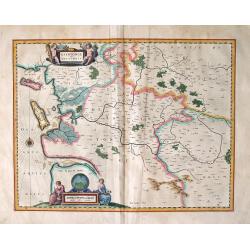
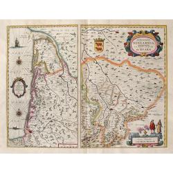
La Principaute d'Orange et Comtat de Venaissin.
A fantastic map of the area around the cities of Avignon and Orange along the Rhone River. Highly detailed with numerous smaller villages shown, mountains, rivers, and fo...
Date: Amsterdam, 1627
Selling price: ????
Please login to see price!
Sold in 2016
Gallia: Nova Galliae descriptio multis in locis de integro emendata simulquae effigies principum, praecipuas Gallorum urbés ac habitus exhibens, excudebat Ioannes Ianssonius Anno 1627.
Decorative map of France with a border containing 14 city views and images of regional costumes. The title cartouche includes the French coat of arms and the date of orig...
Date: Amsterdam, 1627
Selling price: ????
Please login to see price!
Sold in 2020
Carte particuliere des costes de Poittou, Aunis et de la Rochelle.
Finely designed map of Isle Ré and the French coast with La Rochelle.Title cartouche with title in French and Dutch. Underneath insets of fortifications of St. Martin an...
Date: Amsterdam, 1627
Selling price: ????
Please login to see price!
Sold
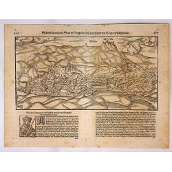
Salin die Namhaffte Stadt in Burgund Nach Ihrer Figur und Gelegenheit Abgemalet.
A woodcut of Salin, in France by Sebastian Münster. Salin-les-Bains in the Jura, the walled city with fortifications and the castle Belim. From his famous Cosmographia, ...
Date: Basel, 1628
Selling price: ????
Please login to see price!
Sold in 2023
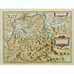
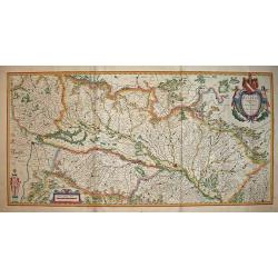
Sabaudia ducatus La Savoie.
Map of the French region of Savoie. Including the towns of Geneva, Grenoble, St. Anton, Val D'Isre, etc. Very dramatic topographic detail in the Alps. With the signature ...
Date: Amsterdam, after 1629
Selling price: ????
Please login to see price!
Sold
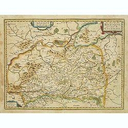
Le duche de Bourgoigne et comte de Charolois
Very detailed map of Bourgogne. Showing Auxerre, Tonnerre, Avalon, Saulieu, Semur, Autun, Vitteau, Arnay-le-Duc, Beaune and Dijon, etc. North to the right side. No text o...
Date: Amsterdam, ca.1630
Selling price: ????
Please login to see price!
Sold
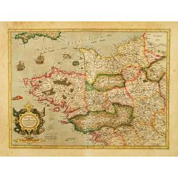
Britannia & Normandia cum consinib regionibus.
Map of Brittany and Normandy, including part of Picardy.
Date: Amsterdam, 1630
Selling price: ????
Please login to see price!
Sold
Bolonia & Guines Comitatus.
An attractive map of north-western France, highlighting the towns of (among others), Montreuil, Boulogne Sur Mer, Calais, Gravelines and St. Omer. Copper engraving publis...
Date: Amsterdam, ca 1630
Selling price: ????
Please login to see price!
Sold in 2021
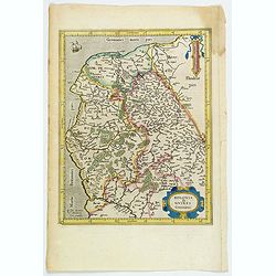
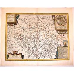
Totius Lemovici et Consinium Provinciarum. . .
Henricus Hondius's hand-colored, copper-plate engraved map of the province of Limoges, France, by Antoin-Jean Fayen, with an inset view of the town of Limoges in the uppe...
Date: Amsterdam, ca. 1630
Selling price: ????
Please login to see price!
Sold in 2018
Duche de Bretaigne. . .
According to van der Krogt in Atlantes Neerlandici, 4450:1.2 (b), this is the variant with the address of Tavernier erased but still visible. Herewith blank verso.With th...
Date: Amsterdam, c. 1630
Selling price: ????
Please login to see price!
Sold in 2018
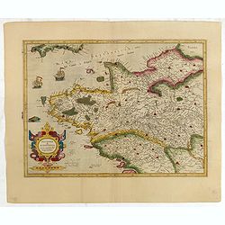
Britannia & Normandia cum consinib regionibus.
Map of Brittany and Normandy, including part of Picardy. Mercator was born in Rupelmonde in Flanders and studied in Louvain under Gemma Frisius, Dutch writer, astronomer ...
Date: Amsterdam, 1630
Selling price: ????
Please login to see price!
Sold in 2015
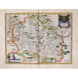
Lorraine, Vers le Midy
A detailed map of Lorraine, published by Le Clerc, based on a map by Mercator. The map is from Le Clerc's "Theatre Geographique du Royaume de France". It is sig...
Date: Paris, 1631
Selling price: ????
Please login to see price!
Sold in 2016
GALLIAE supra omnes ... exactissima descriptio. auctore Henrico Hondio . . .
Fine decorative map of France, including present-day Belgium. Jodocus Hondius Jr. planned to produce a new modern atlas less dependent on the Mercator plates that his fat...
Date: Amsterdam, 1631
Selling price: ????
Please login to see price!
Sold in 2019
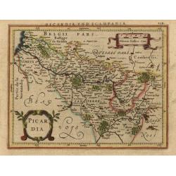
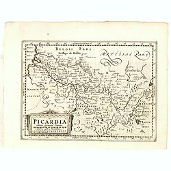
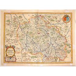
Picardia.
Fine small map reduced from Jansson's folio map of this historic region including the cities of Abbeville, Amiens, Cambrai, Laon, and Compiegne. Fully engraved with citie...
Date: Amsterdam, 1631
Selling price: ????
Please login to see price!
Sold
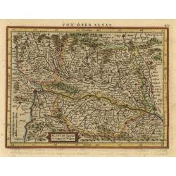
Alsatia superior cu Suntgoia & Brisboia.
Handsome map covering the Alsace region and the course of the Rhine River from Basel to Strasburg. North is oriented to the right. German text on verso.
Date: Amsterdam, 1631
Selling price: ????
Please login to see price!
Sold
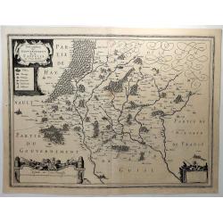
Description du Gouvernement de la Cappelle.
A decorative map of Cappellein, in the region of the Nord-Pas-de-Calais in France. Features three figural decorative cartouches.Pierre Petit Bourbon (1598-1667) was a Fre...
Date: Amsterdam, 1631
Selling price: ????
Please login to see price!
Sold in 2018
Picardia.
Early map of Northern France. With Latin text on verso. Engraved by Petrus Kaerius. Shortly after the publication of big folio-atlases the need was apparently felt for a ...
Date: Amsterdam, 1632
Selling price: ????
Please login to see price!
Sold in 2018
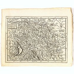
Burgundiae Comitatus Franche comte.
North to the east. Part of France and Switzerland. With Latin text on verso. Engraved by Petrus Kaerius. Shortly after the publication of big folio-atlases the need was a...
Date: Amsterdam, 1632
Selling price: ????
Please login to see price!
Sold in 2018
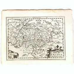
L'Isle de France..
Early map of Paris and surroundings. With Latin text on verso. Engraved by Petrus Kaerius. Shortly after the publication of big folio-atlases the need was apparently felt...
Date: Amsterdam, 1632
Selling price: ????
Please login to see price!
Sold in 2018
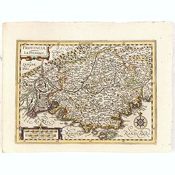
Provincia.
Early map of Southern France. With Latin text on verso. Engraved by Petrus Kaerius. Shortly after the publication of big folio-atlases the need was apparently felt for a ...
Date: Amsterdam, 1632
Selling price: ????
Please login to see price!
Sold in 2015
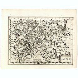
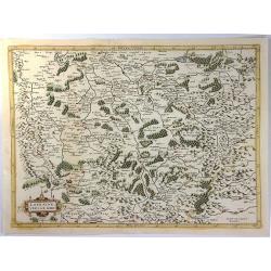
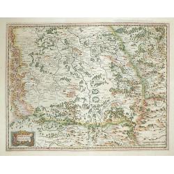
Bresse.
Early map of Eastern France and part of Switzerland. Geneva in upper right corner. With Latin text on verso. Engraved by Petrus Kaerius. Shortly after the publication of ...
Date: Amsterdam, 1632
Selling price: ????
Please login to see price!
Sold in 2018
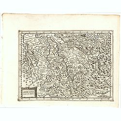
Lorraine Vers Le Midi.
Early map of Lorraine. With Latin text on verso. Engraved by Petrus Kaerius. Shortly after the publication of big folio-atlases the need was apparently felt for a smaller...
Date: Amsterdam, 1632
Selling price: ????
Please login to see price!
Sold in 2018
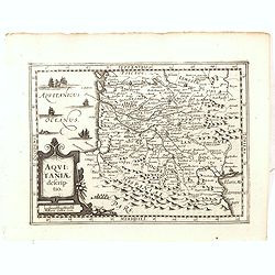
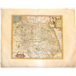
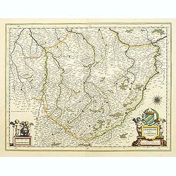
Aquitaniae Descriptio.
Early map of South western France. With Latin text on verso. Engraved by Petrus Kaerius. Shortly after the publication of big folio-atlases the need was apparently felt f...
Date: Amsterdam, 1632
Selling price: ????
Please login to see price!
Sold in 2015
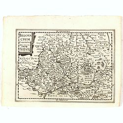
Belovacium comitatus.
Early map centered north of Paris. With Latin text on verso. Engraved by Petrus Kaerius. Shortly after the publication of big folio-atlases the need was apparently felt f...
Date: Amsterdam, 1632
Selling price: ????
Please login to see price!
Sold in 2018
France, Picardie, Champaigne cum Regionibus Adiacentibus.
Pleasant copperplate map of Picardie-Champagne featuring matching chain title & scale cartouches. Notice the crow perched on the title cartouche.Gerard Mercator (1512...
Date: Amsterdam, 1633
Selling price: ????
Please login to see price!
Sold in 2015
Picardia.
Attractive hand-colored, copper engraved map of Picardie, the most northwestern region of France, bordering with Belgium. It features the cities of Amiens, Abbeville and ...
Date: Amsterdam, 1633
Selling price: ????
Please login to see price!
Sold in 2016
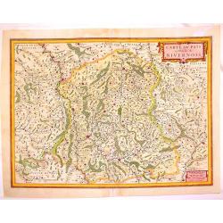
Carte du Pais et Duche de Nivernois.
Fin e map of the Duchy of Nivernois in the Burgogne region of France. Fully detailed with cities, towns, mountains, rivers, lakes and forests. Features tht towns of Bourg...
Date: Amsterdam, 1633
Selling price: ????
Please login to see price!
Sold in 2013
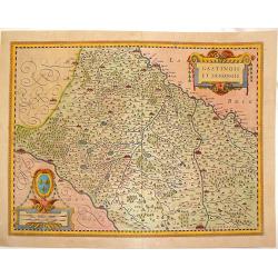
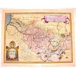
Gastinois et Senonois.
Pleasant copperplate map of regional France with detailed presentation of rivers, lakes, cities towns and forests. Cities include Orleans, Montargis, Sens, Corbeil and Me...
Date: Amsterdam, 1633
Selling price: ????
Please login to see price!
Sold in 2016
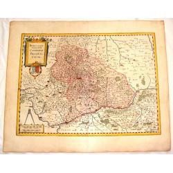
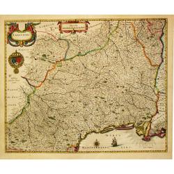
Aquitania Australis Regnu Arelatense Cum Consinijs.
Map of Southern France (from the Pyrenees to Monaco),featuring Auvergne, Bourgogne, Limousine, Provence and Languedoc. Decorated with two matching strapwork cartouches (...
Date: Amsterdam, 1633
Selling price: ????
Please login to see price!
Sold in 2013
Miliaria Burgundie Comitatus Commonia.
Fine 381 year old map of Franche Comte (France & Switzerland) including detail of cities,mountains, rivers, lakes and trees. Small decorative combination title & ...
Date: Amsterdam, 1633
Selling price: ????
Please login to see price!
Sold in 2015
Bourbonois Borbonium Ducatus.
Fine copper engraved map of the Bourbonois region of France. The map shws the Loire River and the cities of Rendan, Moulins, bourbon, Nevers and Brulles. The title/scale ...
Date: Amsterdam, 1633
Selling price: ????
Please login to see price!
Sold in 2013
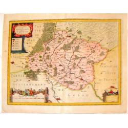
Le Maine.
Striking hand-colored copperplate map featuring the French province of Le Mans. It is very detailed with cities, towns, rivers, lakes and forests. Two lovely cartouches, ...
Date: Amsterdam. 1633
Selling price: ????
Please login to see price!
Sold in 2016
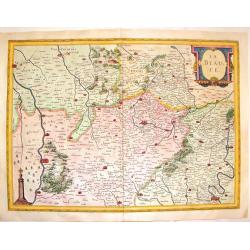
La Beauce.
Decorative, hand-colored, copperplate map featuring the Beauce Region of France.Showing miniature views of Paris, Orleans, Chartres, Oriens and Blois. Seine and Loire riv...
Date: Amsterdam, 1633
Selling price: ????
Please login to see price!
Sold in 2016
Biturigum, le Duche de Berry.
Fine detailed copper engraving of the Duchy of Berry including the cities of Nancy, Bourges and St. Marceau. Three decorative cartouches including a rare castle cartouche...
Date: Amsterdam, 1633
Selling price: ????
Please login to see price!
Sold in 2015
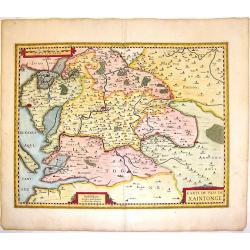
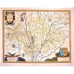
Carte du Pais de Xaintonge.
Decorative copperplate map of the Xaintonge region of France extending from the Atlantic Ocean (La Rochelle, Ille Oleron) to the River Tardoire in the department of Poito...
Date: Amsterdam, 1633
Selling price: ????
Please login to see price!
Sold in 2016
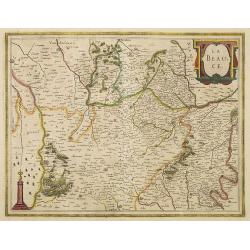
La Beauce.
A very decorative map with beautiful title cartouche of the Beauce region of France - flanked by Paris on the Seine to the north and Orleans on the Loire to the south. A ...
Date: Amsterdam, 1633
Selling price: ????
Please login to see price!
Sold in 2012
Le Pais de Bearn, avec Privilege du Roy.
Handsome copperplate map of Southern France featuring the Bearn region. The major cities shown include Bayonne, Oloron, St. Esprit, Pau, Orthes etc. The Pyrenese Mountain...
Date: Amsterdam, 1633
Selling price: ????
Please login to see price!
Sold in 2014
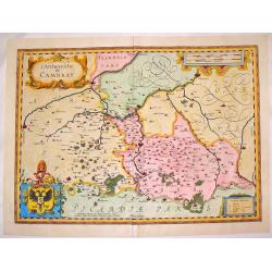
L'Archevesche de Cambray.
Beautiful hand-colored, decorative map of the Cambray region of France that features the cities of Cambray, Valencenne, Douay, and Bouchain. It has four cartouches, one i...
Date: Amsterdam. 1633
Selling price: ????
Please login to see price!
Sold in 2016
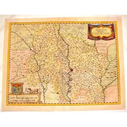
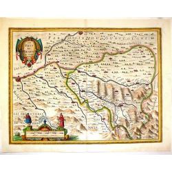
Quercy Cadurcium.
Striking map of the Quercy region of France. The major city is Caors or Cahors. There are two truly remarkable cartouches including the scale cartouche featuring a dog wi...
Date: Amsterdam, 1633
Selling price: ????
Please login to see price!
Sold in 2016
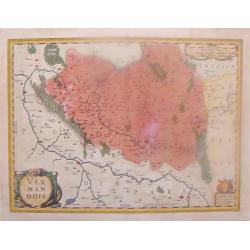
Vermandois.
Hand-colored copper engraved map featuring the region of Vernandois in the northern province of Picardy. The main cities are St. Quentin, Han & Perone. There are thre...
Date: Amsterdam, 1633
Selling price: ????
Please login to see price!
Sold in 2015
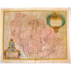
Totius Lemovici et Confinium Provinciarum.
A very decorative map of Limoge, France prepared by Jean du Fayen featuring FOUR lovely cartouches. The cartouche in the upper right corner shows a bird's-eye view of Lim...
Date: Amsterdam, 1633
Selling price: ????
Please login to see price!
Sold in 2015
Beauvaisis Comitatus Belovacium.
Pleasing map of the Beuavais region of France. Decorative title cartouche with royal arms and drapery style scale cartouche with comapass. Gerard Mercator (1512-1594) wa...
Date: Amsterdam. 1633
Selling price: ????
Please login to see price!
Sold in 2016
Description du Blaisois, Anno 1630.
Superb copperplate map of the Blois region of France with THREE very fancy cartouches. The title and scale cartouches have faces of monsters. The map features the Loire R...
Date: Amsterdam, 1633
Selling price: ????
Please login to see price!
Sold in 2016
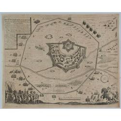
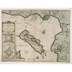
Abriss der Statt und Cittadelle Perpignia sampt dem Stat der Kön. Armee und Derselben Circumvallation.
A fine print that shows a plan of the walled city of Perpignan, in France, and its star shaped fortress surrounded by outer fortifications and troop formations. In the f...
Date: Basel, 1633
Selling price: ????
Please login to see price!
Sold in 2019
Lorraine, vers le Midy.
Copper-engraving, Decorative map showing the center of the Lorraine. The map provides an enormous amount of place names, small villages, and towns. As well rivers, lakes,...
Date: Amsterdam, 1633
Selling price: ????
Please login to see price!
Sold in 2012
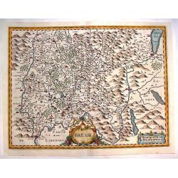
Bresse
Detailed map of Bresse in the Burgundy region of France. French text describing Bresse is on verso. Large decorative cartouche. From Atlas, das ist, Abbildung der Gantzen...
Date: Amsterdam, 1633
Selling price: ????
Please login to see price!
Sold in 2013
Description du Gouvernement de la Cappelle.
Striking copper engraved map with three fancy cartouches. Features Cappellein, the region of the Nord-Pas-de-Calais in France. Engraved by Pierre Boubon (1598-1667) Gera...
Date: Amsterdam, 1633
Selling price: ????
Please login to see price!
Sold in 2016
Carte de Bresse.
Map of the center of France. In lower left corner Lyon. In upper right corner Geneva. Nicolas Tassin, who was active from 1633 till 1655, was appointed 'royal cartographe...
Date: Paris, 1634
Selling price: ????
Please login to see price!
Sold
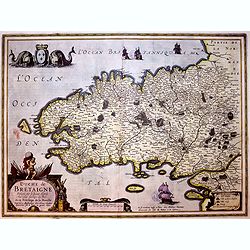
![Carte de Bretagne. [12].](/uploads/cache/13859-250x250.jpg)
Carte de Bretagne. [12].
"Attractive map of Bretagne. Depicts sailing vessels in the Ocean. Includes title in an ornamental cartouche on the upper left-hand corner. The atlas of the "&q...
Date: Paris 1634
Selling price: ????
Please login to see price!
Sold
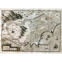
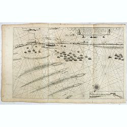
St Tropez.
Early view of St. Tropez showing the fortifications. The harbour with several sailing ships. Published by Nicolas Tassin in "Les Plans et Profilz de toutes principal...
Date: Paris, c1634
Selling price: ????
Please login to see price!
Sold in 2013
Carte de Berry.
Very fine and detailed map centered on Bourges. Embellished with a decorative title cartouche, a scale cartouche and a wind rose.Nicolas Tassin, who was active from 1633 ...
Date: Paris, 1634
Selling price: ????
Please login to see price!
Sold in 2015
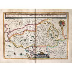
Poitou: Pictaviae Ducatus Descriptio, Vulgo Le Pais De Poictov.
Attractive folio-size map showing Poitou with Rochelle, Nantes, etc. from Blaeu's atlas of 1634.
Date: Amsterdam, 1634
Selling price: ????
Please login to see price!
Sold in 2014
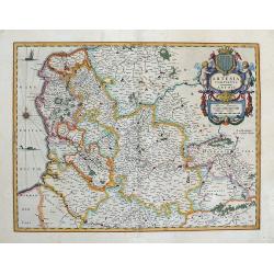
Artesia Comitatus. Artois. Amsterdami Apud Guiljelmum Blaeuw.
The first appearance of this map in an atlas (The Novus Atlas of 1634).Very decorative map of north-western part of France encompassing the region of Artois on the border...
Date: Amsterdam, 1634
Selling price: ????
Please login to see price!
Sold in 2013
Afbeeldinghe van de vermaerde seehaven ende stadt van Duynkercken...
FIRST EDITION, FIRST ISSUE OF THIS MAP. From the 1634 edition of Blaeu's Atlas Novus, the first edition of this work and the very first time Blaeu printed this map. RARE....
Date: Amsterdam, 1634
Selling price: ????
Please login to see price!
Sold in 2019
AGER PARISIENSIS Vulgo L'ISLE DE FRANCE ... / Apud Guiljelmum Blaeu.
This is the first appearance of Blaeu’s map of Paris and its surrounding region; from Blaeu's atlas of 1634. Paris is shown toward the bottom center of the map with th...
Date: Amsterdam, 1634
Selling price: ????
Please login to see price!
Sold in 2012
Saintonge and Aunis : Xaintonge et Angovmois.
Folio-size map of Saintonge and Aunis. With attractive cartouche. From an edition of Blaeu's atlas of 1634.
Date: Amsterdam, 1634
Selling price: ????
Please login to see price!
Sold in 2014
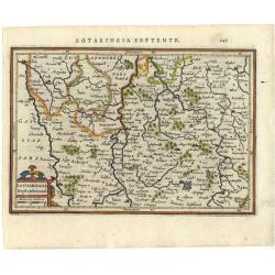
Lotharingia Septentrional.
Detailed map of the North/east part of France. Decorated with a small strapwork title cartouche. Latin text on verso.
Date: Amsterdam 1634
Selling price: ????
Please login to see price!
Sold
Carte du duché d'Aniou.
Very fine and detailed map with the Loire River, centered on Angers and its surrounding area. Embellished with decorative title and scale cartouche and a wind rose.Nicola...
Date: Paris, 1634
Selling price: ????
Please login to see price!
Sold in 2015
Carte d'Auvergne.
Map of Auvergne. Beautiful title cartouche affecting the form of a sea monster. Nicolas Tassin, who was active from 1633 till 1655, was appointed 'royal cartographer' at ...
Date: Paris, 1634
Selling price: ????
Please login to see price!
Sold
Ducatus Andegavensis, Auctore Licimo Guÿeto Andegavense. Aniou.
A detailed map centered on the beautiful and famous Loire river valley. Showing Angers and Saumur. As you might expect the map is covered with rivers and tributaries, tog...
Date: Amsterdam, 1634
Selling price: ????
Please login to see price!
Sold
Carte du Bourdelois../ Principatus Benearnia.
Blaeu's folio map of Bordeaux. depicting The Garonne, The Arcachon basin and the country of the Landes. Also showing Bayonne. Two maps on one sheet. Embellished with beau...
Date: Amsterdam, 1634
Selling price: ????
Please login to see price!
Sold in 2014
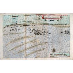
Afbeeldinghe van de vermaerde seehaven ende stadt van Duynkercken . . .
Large decorative and detailed chart of the coast of France from Dunkerque to Calais [with inset view extending from Waldam to Calais at bottom right] showing fleets ancho...
Date: Amsterdam, 1634
Selling price: ????
Please login to see price!
Sold in 2013
Bourbon: BORBONIUM DUVATUS BOURBONNOIS.
A finely detailed map of Bourbon with a large cartouche at bottom left and an attractive coat of arms at top right.
Date: Amsterdam, (1631) 1634
Selling price: ????
Please login to see price!
Sold in 2014
Alsatia Landgraviatus, cum Suntgoia et Brisgola. Ger. Mercatore Auctore. Guiljelm Blaeu excudit.
First appearance of this map in an atlas (the 1634 Atlas Novus).Large map of Alsace based on the work of Gerard Mercator (Mercatorem Auctore). Covers a region focused on ...
Date: Amsterdam, 1634
Selling price: ????
Please login to see price!
Sold in 2013
La Principauté d'ORANGE et Comtat de VENAISSIN. Par Jacques de Chieze.
A beautiful map of Orange and Avignon, decorated with finely engraved title cartouches. South to the top. Lower right early signature of Willem Blaeu: Guiljelmus Janssoni...
Date: Amsterdam , ca. 1635
Selling price: ????
Please login to see price!
Sold in 2022
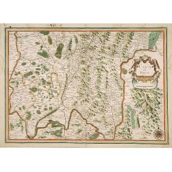
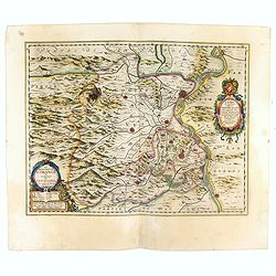
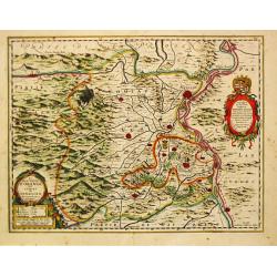
Territorium Metense.
A beautiful colored engraved map centred on Metz in France. Cartouche decorated with a chain of leaves and fruits and three coats of arms. The author of this map was the ...
Date: Amsterdam, 1635
Selling price: ????
Please login to see price!
Sold in 2009
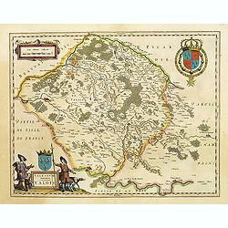
Valesium Ducatus. Valois
The map shows the area between Senlis, Compiègne, Soissons and Meaux which was the ancient duché de Valois. In the left-hand lower part of the image a beautiful cartouc...
Date: Amsterdam, 1635
Selling price: ????
Please login to see price!
Sold in 2009
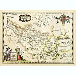
Picardia Regio Belgica, Auctore Ioanne Surhonio.
A map of Picardie centered on the city of Amiens. Two beautiful and colored cartouches. The one in the left-hand lower part is decorated with two human figures. In the up...
Date: Amsterdam, 1635
Selling price: ????
Please login to see price!
Sold in 2009
Belsia, Vulgo la BEAUSSE.
In the left-hand lower part of the image a beautiful contemporary colored cartouche with goddess Ceres [agricultural] holding a reaping-hook in her right hand and receivi...
Date: Amsterdam, 1635
Selling price: ????
Please login to see price!
Sold in 2013
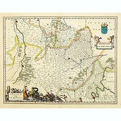
Champagne latine Campania, comitatus.
A good engraved map embellished with two decorative scale cartouches showing putti.
Date: Amsterdam, 1635
Selling price: ????
Please login to see price!
Sold in 2015
Lotharingia Ducatus Vulgo LORRAINE.
This is a map of Lorraine with a coat of arms.
Date: Amsterdam, 1635
Selling price: ????
Please login to see price!
Sold in 2009
Gallia Vetus, Ad iul Caesaris Commentaria, ex conatibus geographicis Abrah Ortelii.
Decorative map depicting the Roman Empire during Caesar.
Date: Amsterdam, 1635
Selling price: ????
Please login to see price!
Sold
Lionnois, Forest, Beaujolois et Masconnois.
A map of the northern area of Lyon. In the left-hand upper part, a cartouche with two cherubs and a coast of arms.In the left-hand lower part, a third putti with surveyor...
Date: Amsterdam, 1635
Selling price: ????
Please login to see price!
Sold
MESSIN. Nova Territorii Metensis Descriptio Autore Abrahamo Fabert Consule Urbis Metensis.
A finely engraved map centered on Metz in France. The author of this map was the French printer Abraham Fabert (1560-1638).No text on verso. From a French composite atlas...
Date: Amsterdam, ca. 1635
Selling price: ????
Please login to see price!
Sold
La Principaute d\' Orange et Comtat de Venaissin Par Iaques se Chieze Oraqngeois. 1627.
Willem Blaeu was the founder of the famous publishing firm. Johan succeeded his father when the latter died in 1638. He led the Blaeu firm to its greatest achievement the...
Date: Amsterdam, 1635
Selling price: ????
Please login to see price!
Sold in 2009
Languedoc.
Willem Blaeu was the founder of the famous publishing firm. Johan succeeded his father when the latter died in 1638. He led the Blaeu firm to its greatest achievement the...
Date: Amsterdam, 1635
Selling price: ????
Please login to see price!
Sold in 2017
