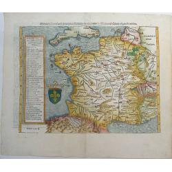
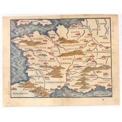
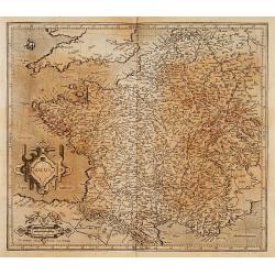
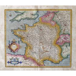
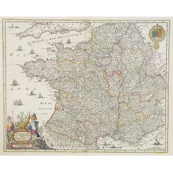
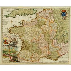
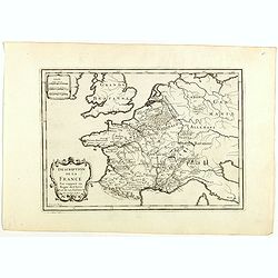
Das gantz Franckreich, so vor zeiten Gallia Narbonensis, Lugdunensis, Belgica und Celtica ist genent worden.
One of the earliest maps of France by Sebastian Münster. With the southern part of England. The title on verso is surrounded by a large and beautiful woodcut border. Fro...
Date: Basel, ca 1540
Selling price: ????
Please login to see price!
Sold in 2019
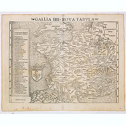
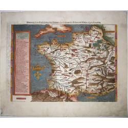
Gallia IIII Nova Tabula (France)
Sebastian Münster's map of France. Appeared in his "Geographia Universalis", first published in 1540. The Geographia was a new and important edition of Ptolemy...
Date: Basel, Heinrich Petri, 1545
Selling price: ????
Please login to see price!
Sold
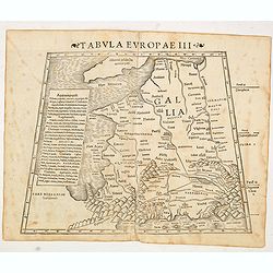
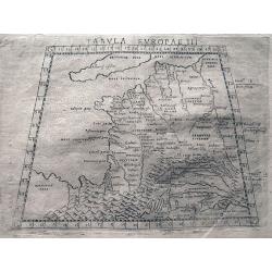
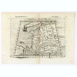
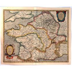
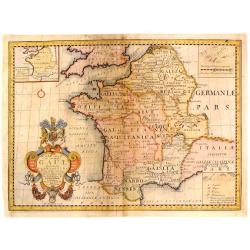
Tabula Europae III (France)
The first edition of Munster's Ptolemaic map of France appeared in his "Geographia Universalis", first published in 1540. This was a new and important edition o...
Date: Basel, Heinrich Petri, 1545
Selling price: ????
Please login to see price!
Sold in 2016
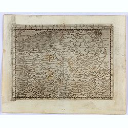
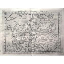
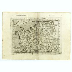
Gallia Nova Tavola.
Gastaldi's modern map of France. From Giacomo Gastaldi's Atlas of 1548, which has been called the most comprehensive atlas, produced between Martin Waldseemüller's Geogr...
Date: Venice, 1548
Selling price: ????
Please login to see price!
Sold in 2021
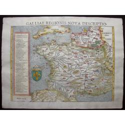
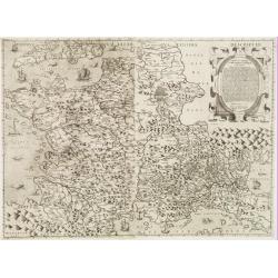
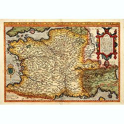
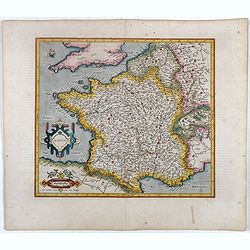
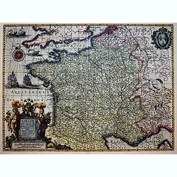
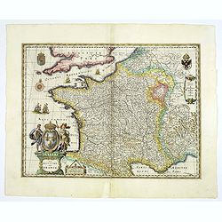
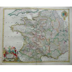
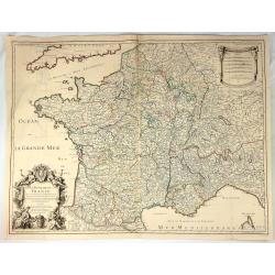
Galliae Regionis Nova Descriptio.
Sebastian Münster's handsome and fascinating 1550 map of France and Belgium from the Pyrenees to Holland, also showing the south coast of England and the Channel Islands...
Date: Basle, 1550
Selling price: ????
Please login to see price!
Sold in 2014
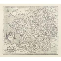
Das gantz Franckreich..Belgica und Celtica. . .
This fine and beautifully hand colored original antique map of modern contemporary France in the mid 16th century was published by Sebastian Münster in the 1550's. Date ...
Date: Basel, ca 1550
Selling price: ????
Please login to see price!
Sold in 2020
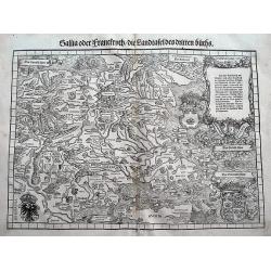
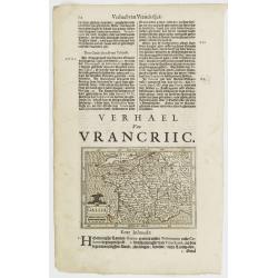
Gallia oder Franckrych / Die Landtafel des dritten Buchs.
One of the earliest available maps of France. The wood cut printed map also shows small parts of Italy, Germany, and England. Filled with place names, rivers, mountains, ...
Date: Zurich, ca 1550
Selling price: ????
Please login to see price!
Sold in 2018
Tabula Europae III.
Ptolemaic style map of France, the Low Countries, and the Rhine river. Includes numerous historic place names. Italian text on verso.
Date: Venice, c1561
Selling price: ????
Please login to see price!
Sold in 2013
![[De Regionibus, Ubibus et Fluviis Galliae . . . ]](/uploads/cache/38524-250x250.jpg)
[De Regionibus, Ubibus et Fluviis Galliae . . . ]
One text page with a map of Europe on the recto (12,2 x 15,5 cm). From Münster's Cosmographia Universalis.The Cosmographia by Sebastian Munster from 1544 is the earliest...
Date: Basle, ca. 1564
Selling price: ????
Please login to see price!
Sold in 2022
Tabula Europae III (France)
Early map of France. Girolamo Ruscelli first published the map in his "La Geographi di Claudio Tolomeo" (Venice, 1561). In 1574 a new plate was used which laste...
Date: Venice, 1564
Selling price: ????
Please login to see price!
Sold in 2020
![[De Galliae et eius fitu, item de eius patitione . . . . . . ]](/uploads/cache/38525-250x250.jpg)
[De Galliae et eius fitu, item de eius patitione . . . . . . ]
One text page with a map of France on the recto (7,8 x 13,5 cm). On verso, a text page in one hand , and in the other a horn from Münster's Cosmographia Universalis.The ...
Date: Basle, ca. 1564
Selling price: ????
Please login to see price!
Sold in 2018
Galliae exactissima descriptio.
A unique opportunity to acquire a fine example from a map from the early Lafreri school. It was the custom for Italian map sellers to bind together available maps into a ...
Date: Venice, 1566
Selling price: ????
Please login to see price!
Sold
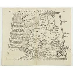
Tabula Galliae. (France)
Double-page woodcut Ptolemaic-style map by Sebastian Münster figuring France, published in the edition of Strabo by Henri Petri in 1571."Strabonis rerum geographica...
Date: Basle, Henri Petri, 1571
Selling price: ????
Please login to see price!
Sold in 2018
Gallia Nova Tabula.
Early map showing parts of France, Belgium, Luxembourg, Germany, Switzerland, Cornwall, and the Ligurian coast with Genoa and Milan. Engraved with mountains and rivers wi...
Date: Venice, c1574
Selling price: ????
Please login to see price!
Sold in 2013
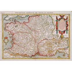
Description Générale de toute la France.
Detailed and uncommon wood block map of France after Ortelius, from François Belleforest's Paris version of Münster's cosmography : Histoire Universe du Monde ..
Date: Paris 1575
Selling price: ????
Please login to see price!
Sold
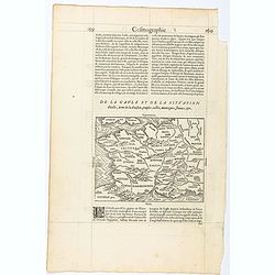
Page from La Cosmographie Universelle with map of France. (Page 160)
Text page with woodblock map of ancient France (122 x 163 mm.) In 1575 Sebastian Münster's Cosmographia was translated into French and published in Paris by François d...
Date: Paris, 1575
Selling price: ????
Please login to see price!
Sold in 2025
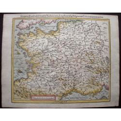
Das gantz Franckreich, so vorzeiten Narbonensis, Lugdunensis, Belgica und Celtica, ist genennt worden.
This nicely colored, charming early woodcut map of France was published in the 1588-edition of Sebastian Münster’s Cosmographia. Mountains, villages, churches and wood...
Date: Basle, S.H. Petrie, 1588
Selling price: ????
Please login to see price!
Sold in 2014
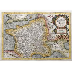
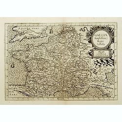
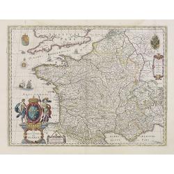
Galliae Amplissimi Regni tabula.
Very rare map which was only published once in the 1593 edition of the Speculum orbis terrae. A highly decorative and beautifully engraved map. Centered on France, also ...
Date: Antwerp, 1593
Selling price: ????
Please login to see price!
Sold in 2021
Galliae Amplissimi regni tabula..
Rare map of France.
Date: Antwerp, 1593
Selling price: ????
Please login to see price!
Sold
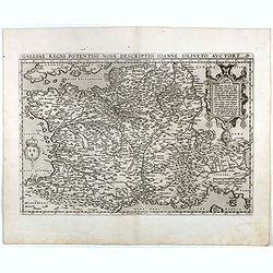
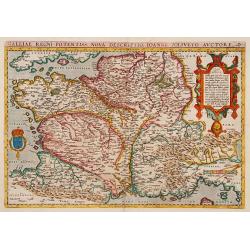
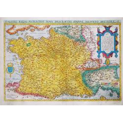
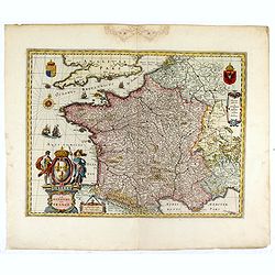
Galliae Regni Potentiss: Nova Descriptio Ioanne Ioliveto Auctore.
A decorative view of 16th Century France that is derived from Jean Jolivet's woodcut map of 1560. Decorated with one large cartouche and one smaller royal crest. The map ...
Date: Antwerp, 1595
Selling price: ????
Please login to see price!
Sold in 2016
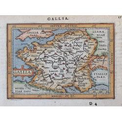
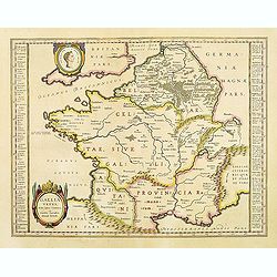
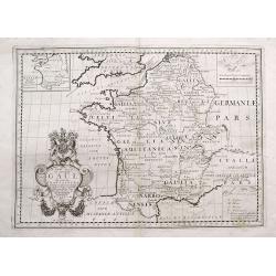
Gallia.
Rather crude but quite charming little woodcut map of Gallia with Celtica, Aquitania, Angliar Pars, Narbonensis, Hispaniae Pars etc., based on Ortelius. Published in 1595...
Date: Venice, 1595
Selling price: ????
Please login to see price!
Sold in 2016
Galliae Regni Potentiss: Nova Descriptio Ioanne Ioliveto Auc
A decorative view of 16th Century France that is derived from Jean Jolivet's woodcut map of 1560. Decorated with one large cartouche and one smaller royal crest. The map ...
Date: Anvers, 1598
Selling price: ????
Please login to see price!
Sold
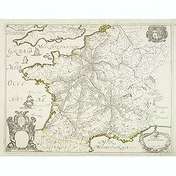
Gallia Nova Tabula.
The third state of Ruscelli's map of France, based upon Claudius Ptolemy. Girolamo Ruscelli first published the map in his "La Geographi di Claudio Tolomeo" (Ve...
Date: Venice, 1598
Selling price: ????
Please login to see price!
Sold in 2018
Galliae Regni Potentiss: Nova Descriptio Ioanne Ioliveto Auctore.
A decorative view of 16th Century France that is derived from Jean Jolivet's woodcut map of 1560. Decorated with one large cartouche and one smaller royal crest. The map ...
Date: Antwerp, 1598
Selling price: ????
Please login to see price!
Sold
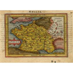
Gallia.
Fine map of France.Mercator was born in Rupelmonde in Flanders and studied in Louvain under Gemma Frisius, Dutch writer, astronomer and mathematician. The excellence of h...
Date: Amsterdam, 1606
Selling price: ????
Please login to see price!
Sold in 2016
Gallia.
Fine map of France.Mercator was born in Rupelmonde in Flanders and studied in Louvain under Gemma Frisius, Dutch writer, astronomer and mathematician. The excellence of h...
Date: Amsterdam, 1606
Selling price: ????
Please login to see price!
Sold
Gallia.
Fine map of France.Mercator was born in Rupelmonde in Flanders and studied in Louvain under Gemma Frisius, Dutch writer, astronomer and mathematician. The excellence of h...
Date: Amsterdam 1606
Selling price: ????
Please login to see price!
Sold
Galliae Regni Potensiss: Nova Descriptio, Ioanne Ioliveto Auctore.
Abraham Ortelius' map of France is a copy of Jean Jolivet's 4-sheet woodcut map of France.Abraham Ortelius(1527-98), Dutch cartographer and publisher of the first modern ...
Date: Antwerp, 1570-1608
Selling price: ????
Please login to see price!
Sold in 2017
Gallia.
A charming miniature map of France with major cities shown. Extends to show London, Cologne, Bern, and Coblenz. Latin text on verso.
Date: Antwerp, 1609
Selling price: ????
Please login to see price!
Sold in 2017
Gallia
Miniature map of France, with major cities named. The sea is stipple engraved. Strapwork title cartouche at left. Latin text on verso.
Date: Antwerp 1609
Selling price: ????
Please login to see price!
Sold
Gallia / Per Gerardum Mercatorem.
An early map of France by Gerard Mercator.Gerard Mercator (1512-1594) was one of the most famous geographers of his time. He was renowned as a scholar in his day, and hi...
Date: Druisburg and then Amsterdam, 1613
Selling price: ????
Please login to see price!
Sold in 2012
Gallia.
Small map of France, surrounded by text in Dutch. Nicolaes de Clerck (de Klerc) was active as engraver and publisher in Delft from 1599-1621.Included in the rare book : W...
Date: Amsterdam, Cloppenburch, 1621
Selling price: ????
Please login to see price!
Sold
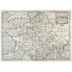
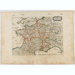
Notitia Chorographica Episcopatuum Galliae.
Historical map of France.
Date: Paris, 1625
Selling price: ????
Please login to see price!
Sold in 2009
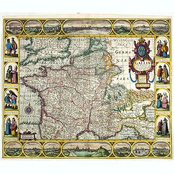
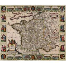
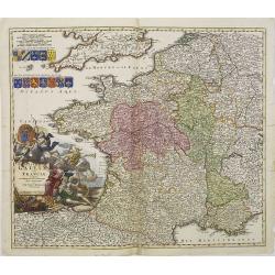
Gallia: Nova Galliae descriptio multis in locis de integro emendata simulquae effigies principum, praecipuas Gallorum urbés ac habitus exhibens, excudebat Ioannes Ianssonius Anno 1627.
Decorative map of France with a border containing 14 city views and images of regional costumes. The title cartouche includes the French coat of arms and the date of orig...
Date: Amsterdam, 1627
Selling price: ????
Please login to see price!
Sold in 2020
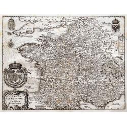
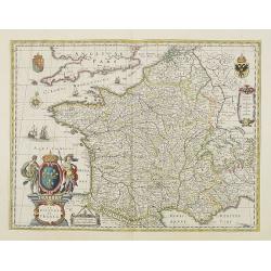
GALLIAE supra omnes ... exactissima descriptio. auctore Henrico Hondio . . .
Fine decorative map of France, including present-day Belgium. Jodocus Hondius Jr. planned to produce a new modern atlas less dependent on the Mercator plates that his fat...
Date: Amsterdam, 1631
Selling price: ????
Please login to see price!
Sold in 2019
GALLIA. Le royaume de France.
Engraved by the master engraver Josua van den Ende. Attractive map of France, title cartouche at lower left, two royal shields above further shields in the upper corners.
Date: Amsterdam, 1635
Selling price: ????
Please login to see price!
Sold in 2011
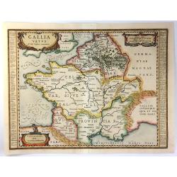
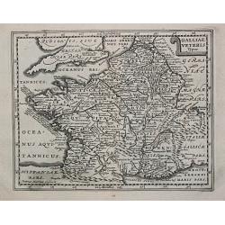
Gallia Vetus, Ad iul Caesaris Commentaria, ex conatibus geographicis Abrah Ortelii.
Decorative map depicting the Roman Empire during Caesar.
Date: Amsterdam, 1635
Selling price: ????
Please login to see price!
Sold
Gallia. Le Royaume de France. Franckreych.
Merian's very decorative and detailed map of France and Switzerland. Richly embellished with coats of arms, a compass rose, and the title cartouche.
Date: Frankfurt, ca. 1636
Selling price: ????
Please login to see price!
Sold in 2016
-250x250.jpg)
Antiquorum Galliae Episcopatuum...
Rare map of ancient France, including Switzerland and the Low Countries. With a large decorative title cartouche. Includes a large inset map of the British Isles.
Date: Paris, 1640
Selling price: ????
Please login to see price!
Sold in 2023
Gallia Antiquae Descriptio, Geographica. . .
An attractive map of ancient Gaul (present day France and Belgium) by the French cartographer Nicolas Sanson, and published by Pierre Mariette. A decorative title cartouc...
Date: Paris, 1641
Selling price: ????
Please login to see price!
Sold in 2010
Gallia Antiqua.
A fine map of ancient France.This edition carries the date 1641.Nicolas Sanson was to bring about the rise of French cartography, although the fierce competition of the D...
Date: Paris 1641
Selling price: ????
Please login to see price!
Sold
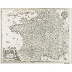
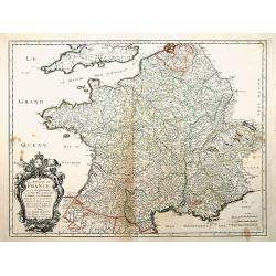
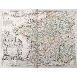
Carte générale du Royaume de France..
This beautifully engraved map depicts France as known in the mid 17th century. Topographical features are shown and major cities, towns, waterways, mountains and islands ...
Date: Paris, 1643
Selling price: ????
Please login to see price!
Sold in 2014

Typus Galliae Veteris, Ex conatib' Geograph. Abrah.Ortelii.
A very decorative map with countries of ancient France prepared by Abraham Ortelius and published by one of the most famous map publishers, Willem Blaeu.
Date: Amsterdam, 1645
Selling price: ????
Please login to see price!
Sold in 2026
Gallia.
Miniature map of France. Text on verso.
Date: London, William Humble, 1646
Selling price: ????
Please login to see price!
Sold in 2020
GALLIA. Le royaume de France.
Engraved by the master engraver Josua van den Ende. Attractive map of France, title cartouche at lower left, two royal shields above further shields in the upper corners.
Date: Amsterdam, 1650
Selling price: ????
Please login to see price!
Sold in 2008
GALLIA. Le royaume de France.
Engraved by the master engraver Josua van den Ende. A very attractive map of France, embellished with a beautiful title cartouche at lower left, two royal shields in the ...
Date: Amsterdam, 1650
Selling price: ????
Please login to see price!
Sold in 2018
Gouvernement General d'Orleans ..
Fine map of south eastern part of France, including Isle de Ré, Paris, S.Malo, etc. This edition carries the date 1650 and the cartouche presents the address of Pierre M...
Date: Paris, 1650
Selling price: ????
Please login to see price!
Sold
Gallia Antiqua et Nova.
Uncommon map of ancient France. Very decorative and of the highest standing of engraving.
Date: Frankfurt, 1650
Selling price: ????
Please login to see price!
Sold in 2019
GALLIA. Le royaume de France.
The map was first published with figured borders (1607). When Blaeu needed a folio size map of France for his first atlas (Appendix 1631) he cut off the borders. The same...
Date: Amsterdam, 1650
Selling price: ????
Please login to see price!
Sold in 2016
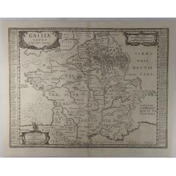
Gallia Vetus ad Iuly Caesaris Commentaria
This striking map of Gallia (ancient France) by Jan Jansson is based on information from Caesar's “De Bello Gallico". It is engraved to show the mountains, rivers ...
Date: Amsterdam, 1650
Selling price: ????
Please login to see price!
Sold in 2016
Galliae Nouael accurata descriptio Vulgo Royaume de France. . .
A map of France.From Merian's Topographia Galliae. . . . In lower left corner fine title cartouche, and upper right coat of arms of France.
Date: Frankfurt, 1655
Selling price: ????
Please login to see price!
Sold
France.
Engraved map of France.
Date: Paris, 1656
Selling price: ????
Please login to see price!
Sold in 2021
Nova Galliae Tabula.
A rare carte à figures of France by Cloppenburg.
Date: Amsterdam, 1657
Selling price: ????
Please login to see price!
Sold in 2017
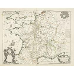
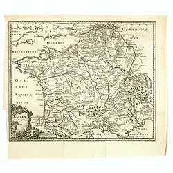
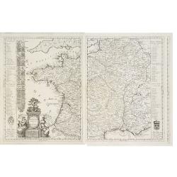
Carte Geograhicque des Postes qui traversent la France. . .
The earliest post road mapspost route map was first published 1632 by Melchior Tavernier - this "Carte Géographique des Postes qui traversent France" shows all...
Date: Paris, 1632-1658
Selling price: ????
Please login to see price!
Sold in 2011
Galliae Veteris Typus.
A pleasing Latin map of France during Roman times, based on Ortelius' map, which in turn was based on ancient geographical sources. The map is filled with detail and anci...
Date: Amsterdam, 1660
Selling price: ????
Please login to see price!
Sold in 2016
Carte Géographique des Postes qui traversent la France.
Attractive map of France shows post road mapspost routes connecting major cities, towns and harbors. Depicts sailing vessels in the British Channel and the Bay of Biscay ...
Date: Paris, 1632-1660
Selling price: ????
Please login to see price!
Sold
Gallia. Nova et accurata descriptio vulgo Royaume de France.
Fine map of France with in upper right corner the coats of arms of France.
Date: Amsterdam, 1660
Selling price: ????
Please login to see price!
Sold in 2011
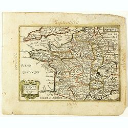
France Nouvellement descripte 1651. (26).
Scarce map of Africa in its second state published by Antoine de Fer in 1661 or 1662 in "Cartes de géographie revues et augmentées".With number 26 in lower ri...
Date: Paris, Antoine de Fer, 1657 but 1661 or 1662
Selling price: ????
Please login to see price!
Sold in 2019
Le Royaume de France, et ses acquisitions..
"Fine map of France. The cartouche presents the address of Pierre Mariette; rue St.Jacques a L'Esperance"". Nicolas Sanson was to bring about the rise of F...
Date: Paris 1665
Selling price: ????
Please login to see price!
Sold
Galliae nova et accurata descriptio vulgo royaume de france.
Standard map of France.
Date: Amsterdam, 1670
Selling price: ????
Please login to see price!
Sold in 2010
![[sea-chart of the Channel between England and France]](/uploads/cache/85520-250x250.jpg)
[sea-chart of the Channel between England and France]
A rare sea-chart of the Channel between England and France. Extends from Portsmouth until Dover in England, and Calais until Cherbourg in Normandy. A large inset map show...
Date: London, ca 1671
Selling price: ????
Please login to see price!
Sold in 2021
Galliae Veterus. Petrus Kaerius Caelavit.
Philippe Cluverius (1580-1622), geographer of Danzig, settled in Leiden (Holland) specialized in Near Easrt and Ancient Geography. His main works ' Geographicus Academicu...
Date: Amsterdam, 1683
Selling price: ????
Please login to see price!
Sold in 2009
Gallia Vetus ad Julij Caesaris Commentaria.
A striking, detailed, copper engraved map of Gallia or Ancient France at the time of Julius Caesar. It is based on information from Caesar's "De Bello Gallico"....
Date: Amsterdam, 1684
Selling price: ????
Please login to see price!
Sold in 2019
![[ France ]](/uploads/cache/30322-250x250.jpg)
[ France ]
Charming wood block map of France by the Italian XVIth and XVIIth century writer, humanist and cartographer Giuseppe Rosaccio. Taken from the 1688 Bologna "Teatro de...
Date: Bologna, Antonio Pisarri, 1594 - 1688
Selling price: ????
Please login to see price!
Sold in 2011
Nova Et Esatta Tavola Del Regno Di Francia..
Rossi's map of France, based upon Sanson's map, but with revised Italian nomenclature. The engraver was Giorgio Widman.In lower left corner a tittle cartouche. The cartog...
Date: Rome, 1677-1688
Selling price: ????
Please login to see price!
Sold in 2015
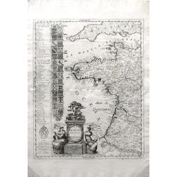
La Francia Antica, e Moderna Dedicata.
A beautiful and rare map in two sheets showing France. To the left coats of arms of the different provinces. With a dedication to Michael Sagramoso. The remarkable Vincen...
Date: Venice, 1690
Selling price: ????
Please login to see price!
Sold in 2012
La Francia Antica, e Moderna Dedicata.
A beautiful and rare map in two sheets showing France. To the left coats of arms of the different provinces. With a dedication to Michael Sagramoso. The remarkable Vincen...
Date: Venice, 1690
Selling price: ????
Please login to see price!
Sold in 2011
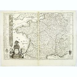
La Francia Antica, e Moderna. . .
Beautiful and finely detailed map of the west coast of France, including the Pyrenees region in the South to the Normandy region in the North by Vincenzo Coronelli. The t...
Date: Venice, 1692
Selling price: ????
Please login to see price!
Sold in 2010
Totius Regni Galliae sive Franciae..
A finely engraved detailed map of France with imposing title cartouche and coats of arms. °
Date: Nuremberg, 1692
Selling price: ????
Please login to see price!
Sold in 2011
Le Royaume de France...
Well engraved 17th century copper engraved map of France. The large title cartouche is surrounded by a plan of Paris and 10 other cities in France.
Date: Paris, 1698
Selling price: ????
Please login to see price!
Sold in 2019
Galliae seu Franciae Tabula.
The map is decorated with a beautiful cartouche relating to Neptune and the four elements and with the French coat of arms.
Date: Amsterdam, ca. 1698
Selling price: ????
Please login to see price!
Sold
A New Map of Ancient Gaul or Gallia Transalpina.
A striking map of Ancient France during the time of Augustus Caesar. Includes a wonderful large title cartouche that includes fruit, ribbons and the Gloucester coat of ar...
Date: Oxford, 1700
Selling price: ????
Please login to see price!
Sold in 2017
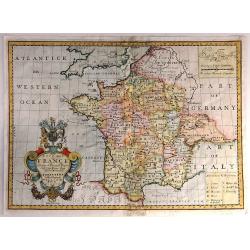
New Map of France Shewing its Principal Divisions, Chief Cities, Townes, Ports, Rivers, Mountains &c. Dedicated to His Highness William Duke of Gloucester...
A striking map of France divided by its provinces, including details such as mountains. The cartouche is splendid, and it includes the Gloucester coat of arms, fruit and ...
Date: Oxford, 1703
Selling price: ????
Please login to see price!
Sold in 2016
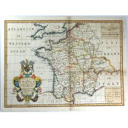
New Map of France Shewing its Principal Divisions, Chief Cities, Townes, Ports, Rivers, Mountains &c. Dedicated to His Highness William Duke of Gloucester....
A striking map of France divided into its provinces, including details such as mountains. The cartouche is splendid, and it includes the Gloucester coat of arms, fruit an...
Date: Oxford, 1703
Selling price: ????
Please login to see price!
Sold in 2016
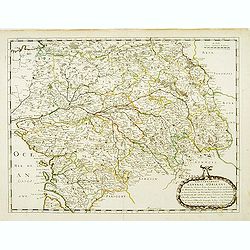
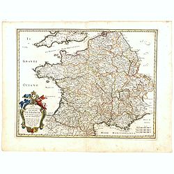
Description de la France par rapport au regne de Clovis et de ses enfants.
Map of France and part of Europe, with great Britain, from Nicolas de Fer's "L'Atlas curieux ou le Monde réprésente dans des cartes. "The "Atlas Curieux&...
Date: Paris, 1705
Selling price: ????
Please login to see price!
Sold in 2022

New Map of Ancient Gaul or Gallia Transalpina.
A fine map of Ancient France engraved by Robert Spofforth, and published by Wells for "A New Sett of Maps Both of Ancient and Present Geography". This map was d...
Date: London, 1710
Selling price: ????
Please login to see price!
Sold in 2023
Le Royaume de France Dresse les Memoires et Nouvelles Observations de Messieurs de l'Academie Royalle de Sciences
Very large, copper engraved map of France. It was published by the Jaillot family in Paris in 1717. The map features a large title cartouche with a coat of arms surround...
Date: Paris , 1717
Selling price: ????
Please login to see price!
Sold in 2018
A New Map of Ancient Gaul or Gallia Transalpina...
Decorative map of France, as divided by Augustus Ceasar during Roman times. With the large title cartouche bearing the Royal Coat of Arms.
Date: London, 1718
Selling price: ????
Please login to see price!
Sold in 2016
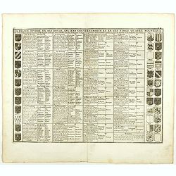
La France divisée en ses douze anciens gouvernements, et en ses vingt quarte nouveaux.
Fine example of Chatelain's attractive plate showing the division of the different governments, decorated with coats-of-arms. Zacharie Chatelain (d.1723) was the father o...
Date: Amsterdam, 1719
Selling price: ????
Please login to see price!
Sold in 2018
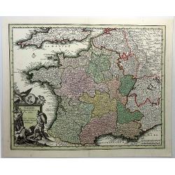
Gallia Cum Provinciis Infertis et Adsitis. . .
A copper engraved detailed map of Ancient France, divided into its provinces by Christopher Weigel in Nurnberg in 1719. Features a decorative cartouche with lions, soldie...
Date: Nurnberg, 1720
Selling price: ????
Please login to see price!
Sold in 2019
