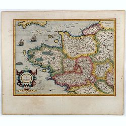
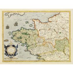
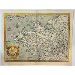
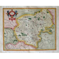
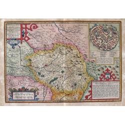
Britannia & Normandia cum consinib regionibus.
Map of Brittany and Normandy, including part of Picardy. Mercator was born in Rupelmonde in Flanders and studied in Louvain under Gemma Frisius, Dutch writer, astronomer ...
Date: Amsterdam, 1606
Selling price: ????
Please login to see price!
Sold in 2016
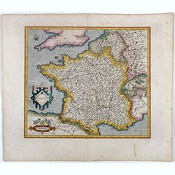
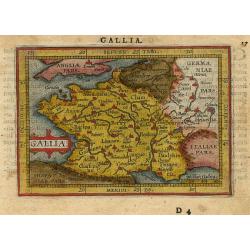
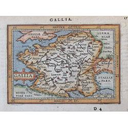
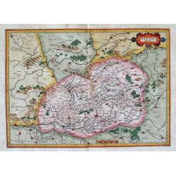
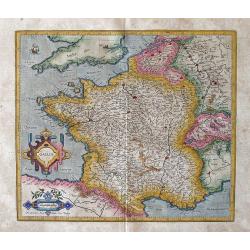
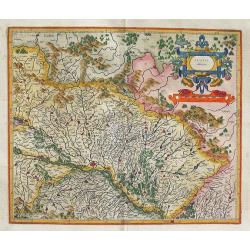
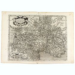
Gallia.
Fine map of France.Mercator was born in Rupelmonde in Flanders and studied in Louvain under Gemma Frisius, Dutch writer, astronomer and mathematician. The excellence of h...
Date: Amsterdam, 1606
Selling price: ????
Please login to see price!
Sold in 2016
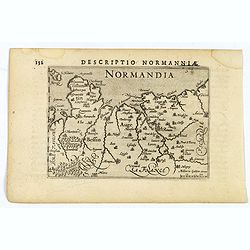
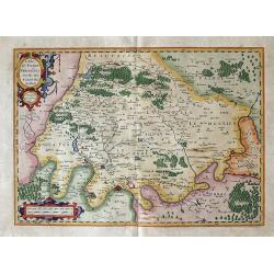
Descriptio Normanniae.
A charming small map of Normandy, showing Rouen ,Amiens, Cherbourg, Harfleur etc. From the Bertius atlas Tabularum geographicarum contractarum. Bertius (1565-1629) was a ...
Date: Amsterdam, 1606
Selling price: ????
Please login to see price!
Sold in 2020
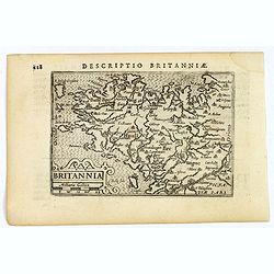
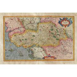
Descriptio Britanniae.
A charming small map of Britany in N.W. France. Showing Brest, St. Malo, Rennes, Nantes etc. From the Bertius atlas Tabularum geographicarum contractarum. Bertius (1565-1...
Date: Amsterdam, 1606
Selling price: ????
Please login to see price!
Sold in 2021
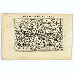
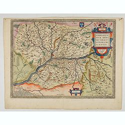
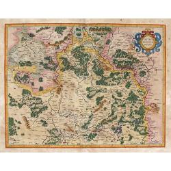
Descriptio Alsatiae.
A decorative miniature map of Alsace - a cultural and historical region in eastern France, on the west bank of the upper Rhine next to Germany and Switzerland. A map full...
Date: Amsterdam, 1606
Selling price: ????
Please login to see price!
Sold in 2019
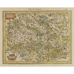
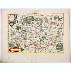
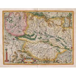
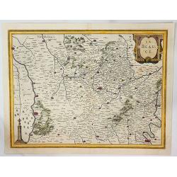
Lotharingia Meridiona.
Map depicting the southern part of the French region Lorraine. From the first French-text edition of Jodocus Hondius'' Atlas Minor.Shortly after the publication of the bi...
Date: Amsterdam, 1608
Selling price: ????
Please login to see price!
Sold in 2011
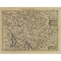
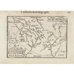
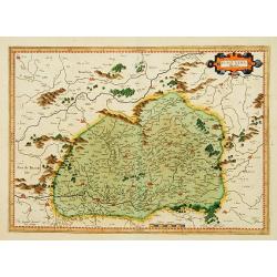
Burgundiae Duca.
Map depicting the French region Burgundy. From the first French-text edition of Jodocus Hondius'' Atlas Minor.Shortly after the publication of the big folio-atlases the n...
Date: Amsterdam, 1608
Selling price: ????
Please login to see price!
Sold in 2008
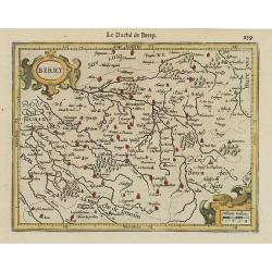
Berry.
Map centered on the French region Berry. From the first French-text edition of Jodocus Hondius' Atlas Minor.Shortly after the publication of the big folio-atlases the nee...
Date: Amsterdam, 1608
Selling price: ????
Please login to see price!
Sold
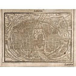
Paris / Lugdunum
Two rare woodcut views of the Paris on the front page and Lyon on the back page. From "Parvum Theatrum Urbium sive Urbium Praecipuarum totius orbis Brevis & Meth...
Date: Frankfurt, 1608
Selling price: ????
Please login to see price!
Sold in 2009
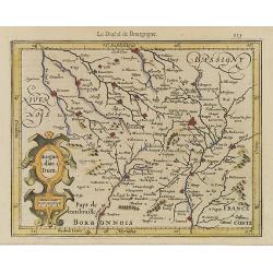
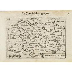
Burgundiae Comitatus.
Map centered on the French region Franche-Comté, extending southwards as far as Lake Geneva.Oriented with West on top. From the first French-text edition of Jodocus Hond...
Date: Amsterdam, 1608
Selling price: ????
Please login to see price!
Sold in 2013
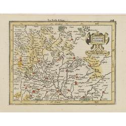
Alsatia Inferior.
Detailed map centered on Strasbourg, oriented with West on top. From the first French-text edition of Jodocus Hondius' Atlas Minor.Shortly after the publication of the bi...
Date: Amsterdam, 1608
Selling price: ????
Please login to see price!
Sold in 2020
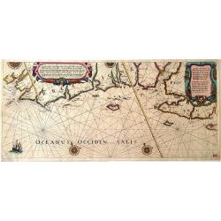
Eygentlijke afbeeldinge...Zee custen van Bretaigne Poictoi.
Very rare sea of the French coast of Brittany and Poictou, running from the Brest to the Loire and beyond. Title cartouche in both Dutch and French text. A beautiful and...
Date: Amsterdam, ca. 1608
Selling price: ????
Please login to see price!
Sold in 2011
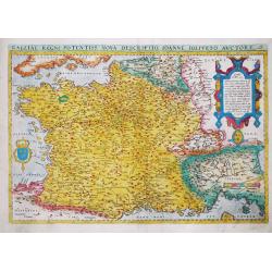
Galliae Regni Potensiss: Nova Descriptio, Ioanne Ioliveto Auctore.
Abraham Ortelius' map of France is a copy of Jean Jolivet's 4-sheet woodcut map of France.Abraham Ortelius(1527-98), Dutch cartographer and publisher of the first modern ...
Date: Antwerp, 1570-1608
Selling price: ????
Please login to see price!
Sold in 2017
Totius Lemovici et. . .
Map of part of France, centered on Limoge, including a plan of Limoge. Prepared by Jean du Fayen (1530-1612), French physician and geographer, who prepared the first know...
Date: Amsterdam, 1608
Selling price: ????
Please login to see price!
Sold in 2016
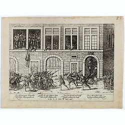
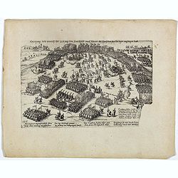
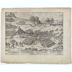
Der Guvernator genant Mottegondrin. Hat die Stat Valencen genomen ein. . . (Valence)
Early print showing a scene in Valence on 25 April 1608.Plate from the series about the " Eighty Years' War" or the independence war of Holland against Spain, w...
Date: Cologne, ca. 1608
Selling price: ????
Please login to see price!
Sold in 2020
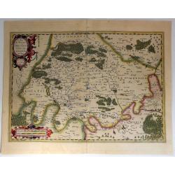
Lotharingia.
A nice small map centered on the French region of Lorraine, oriented with east on top. With some good map detail. From the Latin-text edition of Jodocus Hondius' Atlas Mi...
Date: Amsterdam, 1608
Selling price: ????
Please login to see price!
Sold in 2020
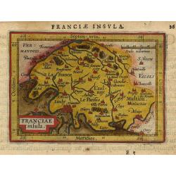
Franciae insula.
Miniature map of Paris area with major cities named, Paris is situated left under. Strapwork title cartouche in the left under corner. Latin text on verso.
Date: Antwerp 1609
Selling price: ????
Please login to see price!
Sold
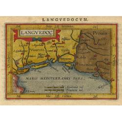
Languedoc.
Miniature map of Languedoc, South France with major cities named, Marseille is in the right border. Sea is stipple engraved. Strapwork title cartouche at the top. Latin t...
Date: Antwerp 1609
Selling price: ????
Please login to see price!
Sold
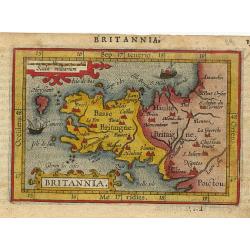
Britannia.
Miniature map of Britannia with major cities named. Sea is stipple engraved and has 2 boats. Strapwork title cartouche at upper left. Latin text on verso.
Date: Antwerp 1609
Selling price: ????
Please login to see price!
Sold
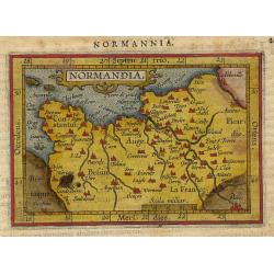
Normandia.
Miniature map of Normandy with major cities named, Paris in the right under corner. Sea is stipple engraved. Strapwork title cartouche at the top. Latin text on verso.
Date: Antwerp 1609
Selling price: ????
Please login to see price!
Sold
Gallia
Miniature map of France, with major cities named. The sea is stipple engraved. Strapwork title cartouche at left. Latin text on verso.
Date: Antwerp 1609
Selling price: ????
Please login to see price!
Sold
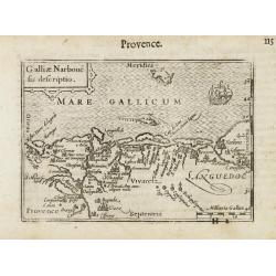
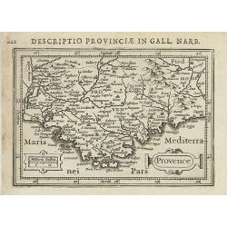
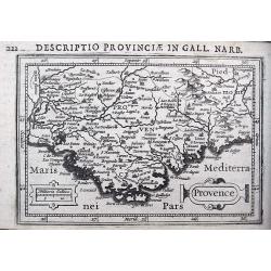
Galliae Narbone sis descriptio.
A miniature map of the Languedoc, including towns of Marseille, Avignon, Narbonne, etc. South to the top. Fine cartouche in the upper left corner. The sea is decorated wi...
Date: Amsterdam/Frankfurt 1609
Selling price: ????
Please login to see price!
Sold
Burgundiae Com.
A miniature map of the Burgundy. Title cartouche in the lower right corner.First published in 1598 in his Caert-Thresoor, the plates were executed by the most famous engr...
Date: Amsterdam/Frankfurt, 1609
Selling price: ????
Please login to see price!
Sold
Burgundiae Ducatus.
A miniature map of the Burgundy. Title cartouche in the lower left corner.First published in 1598 in his Caert-Thresoor, the plates were executed by the most famous engra...
Date: Amsterdam/Frankfurt 1609
Selling price: ????
Please login to see price!
Sold
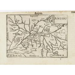
Aniou / Anjou.
A miniature map of the Loire valley, centered on Angers. Title cartouche in the upper right corner.First published in 1598 in his Caert-Thresoor, the plates were executed...
Date: Amsterdam/Frankfurt, 1609
Selling price: ????
Please login to see price!
Sold in 2015
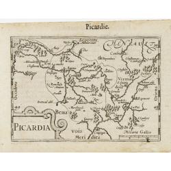
Picardia / Picardie.
A miniature map of northern part of France, centered on Amiens. Title cartouche in the lower left corner.First published in 1598 in his Caert-Thresoor, the plates were ex...
Date: Amsterdam/Frankfurt 1609
Selling price: ????
Please login to see price!
Sold
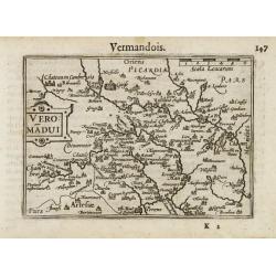
Veromandui / Vermandois.
A miniature map of northern part of France. Title cartouche on the left side.First published in 1598 in his Caert-Thresoor, the plates were executed by the most famous en...
Date: Amsterdam/Frankfurt 1609
Selling price: ????
Please login to see price!
Sold in 2014
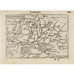
Lotharingia / Lorraine.
A miniature map of eastern part of France. Title cartouche on the upper left corner.First published in 1598 in his Caert-Thresoor, the plates were executed by the most fa...
Date: Amsterdam/Frankfurt 1609
Selling price: ????
Please login to see price!
Sold
Gallia.
A charming miniature map of France with major cities shown. Extends to show London, Cologne, Bern, and Coblenz. Latin text on verso.
Date: Antwerp, 1609
Selling price: ????
Please login to see price!
Sold in 2017
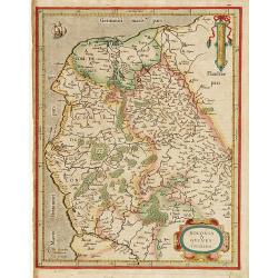
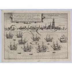
Boloniae & Guines comitatus.
Very fine copper engraving, showing the coastline from Brique till Grevelinge including Calais.Decorated with two finely engraved cartouches.
Date: Amsterdam 1610
Selling price: ????
Please login to see price!
Sold
Burgundia Ducatus.
One of the earliest maps of Burgundy.
Date: Amsterdam 1610
Selling price: ????
Please login to see price!
Sold
Britannia & Normandia cum consinib regionibus.
One of the earliest maps of Brittany and Normandy. Very attractive copy.
Date: Amsterdam, 1610
Selling price: ????
Please login to see price!
Sold in 2008
Erzeignung Wie Henrich der 4. Konig von Franckreich und Navarr, der Teutschen fursten lager empfangen hatt. Plate 278.
Plate from the series about the " Eighty Years' War" or the independence war of Holland against Spain, we know of approximately four hundred engravings by Frans...
Date: Cologne, ca. 1610
Selling price: ????
Please login to see price!
Sold in 2020
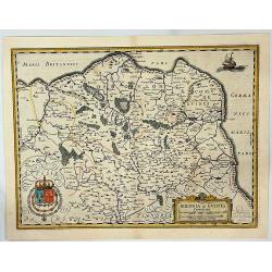
Britannia & Normandia cum Consinib Regionibus.
A Mercator & Hondius map of Brittany and Normandy, including part of Picardy. One of the earliest maps of Brittany and Normandy, it was first published by Mercator in...
Date: Amsterdam, 1610
Selling price: ????
Please login to see price!
Sold in 2017
L'Isle de France, Parisiesis Agri Descriptio Auctore.
This is a handsome and detailed map of the region of Paris and its vicinity, attributed to Francois de la Guillotiere. It is beautifully engraved with forests, rivers, ci...
Date: Amsterdam, ca 1610
Selling price: ????
Please login to see price!
Sold in 2021
![[Lot of 6 maps of the Provence, Marseille, Cannes, Nice, France.] Provenciae, Regionis Galliae, vera exactissimiaqs descriptio. Petro Ionne Bompario auctore. / Provence / Baptista Doetecomius Sculp.](/uploads/cache/18218-(1)-250x250.jpg)
[Lot of 6 maps of the Provence, Marseille, Cannes, Nice, France.] Provenciae, Regionis Galliae, vera exactissimiaqs descriptio. Petro Ionne Bompario auctore. / Provence / Baptista Doetecomius Sculp.
An early and most decorative map of the Provence with the Riviera from the Rhone estuary, Marseille, Cannes, Nice to Vintimiglia. Engraved by Baptista Van Doetechum for...
Date: Amsterdam, c. 1610
Selling price: ????
Please login to see price!
Sold in 2023
Grevelinge / Gravelinga, urbs maritima.
From Ludovico Guicciardini.'s description of the Netherlands ' Beschrijvinghe van alle de Nederlanden anderssins ghenoemt Neder-Duytslandt ', published by Willem Blaeu.A ...
Date: Amsterdam, W.Blaeu, 1612
Selling price: ????
Please login to see price!
Sold in 2008
Lille.
From Ludovico Guicciardini.'s description of the Netherlands ' Beschrijvinghe van alle de Nederlanden anderssins ghenoemt Neder-Duytslandt ', published by Willem Blaeu.A ...
Date: Amsterdam, W.Blaeu, 1612
Selling price: ????
Please login to see price!
Sold in 2010
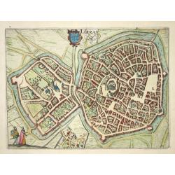
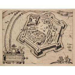
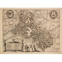
Arras
Nice bird's-eye plan of the city of Arras. Based on Braun & Hogenberg's 1572 plan, the map is filled with detail of the well-laid out city and the surrounding country...
Date: Amsterdam 1612
Selling price: ????
Please login to see price!
Sold
![[Blâmont] - Blanmont au Pays de Vauge en Loreyne.](/uploads/cache/32215-250x250.jpg)
[Blâmont] - Blanmont au Pays de Vauge en Loreyne.
Early bird's-eye of Blâmont in the Lorraine region from the greatest publication in this genre!. The Civitates was compiled and written by George Braun, Canon of Cologn...
Date: Cologne, 1575-1612
Selling price: ????
Please login to see price!
Sold in 2012
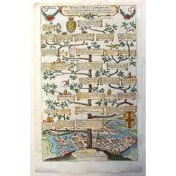
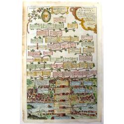
Othones Saxones Imperatories.
Othones Saxones Imperatories is a highly detailed copper engraving featuring the family tree of the rulers of Saxony. At the bottom is a detailed birds-eye view or map of...
Date: Augsburg, 1612
Selling price: ????
Please login to see price!
Sold in 2013
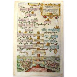
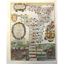
Veteres Duces Lotharingiae.
Veteres Duces Lotharingiae is a highly detailed copper engraving featuring the family tree of the Ducal House of Lorraine. At the bottom is a detailed birds-eye view of t...
Date: Augsburg, 1612
Selling price: ????
Please login to see price!
Sold in 2013
Blesenses Comites.
Blesenses Comites is a highly detailed copper engraving featuring the family tree of the rulers of Blois. At the bottom is a detailed birds-eye view of the town of Blois....
Date: Augsburg, 1612
Selling price: ????
Please login to see price!
Sold in 2013
Comites ac Duces Wirtembergici.
\\\"Comites ac Duces Wirtembergici\\\" is a highly detailed copper engraving featuring the family tree of the Counts & Dukes of Wurttemberg. At the bottom i...
Date: Augsburg, 1612
Selling price: ????
Please login to see price!
Sold in 2013
Duijkkerken Praecipus Totius Flandriae.
Beautiful bird's eye-view plan of the town of Duinkerken, France on the Belgian border. From Ludovico Guicciardini's description of the Netherlands 'Beschrijvinghe Van A...
Date: Amsterdam, 1612
Selling price: ????
Please login to see price!
Sold in 2019
Andegavensium Ditionis Vera et Intregra Descriptio.
Early map of the Loire Valley, with Angiers in the center. Prepared by Lézin Guyet in 1579.
Date: Antwerp, 1608-1612
Selling price: ????
Please login to see price!
Sold in 2022
![Lorraine, southern part: [untitled map].](/uploads/cache/92552-250x250.jpg)
Lorraine, southern part: [untitled map].
Map of Lorraine, with Moselle River. Nancy at top center. North at top. A typically and finely engraved map by Mercator.The map first appeared in 1585, and then again in ...
Date: Duisburg and then Amsterdam, (1585-95) 1613
Selling price: ????
Please login to see price!
Sold in 2014
BERRY Ducatus per Gerardum Mercatorem.
Map of Berry centered on the city of Bourges.The map first appeared in 1585 and then again in 1595 in Mercator's Atlas. In 1604, the copperplates for the atlas were sold ...
Date: Duisburg and then Amsterdam, (1585-95) 1613
Selling price: ????
Please login to see price!
Sold in 2013
BURGUNDIA Ducatus Per Gerardum Mercatorem.
Map of Burgundy. The map first appeared in 1585 and then again in 1595 in Mercator's Atlas. In 1604, the copperplates for the atlas were sold to Jodocus Hondius and Corne...
Date: Duisburg and then Amsterdam, (1585-95) 1613
Selling price: ????
Please login to see price!
Sold in 2013
![Burgundy, etc. [Unititled map].](/uploads/cache/92555-250x250.jpg)
Burgundy, etc. [Unititled map].
Map of Burgundy, with Lake Geneva at left. North at the right side of the map. The map first appeared in 1585. In 1604, the copperplates for the atlas were sold to Jodocu...
Date: Duisburg and then Amsterdam, (1585-95) 1613
Selling price: ????
Please login to see price!
Sold in 2014
POICTOV sive Pictauiae descriptio.
Map of Poictou centered on the city of Poitiers. With a decorative title-cartouche, a sailing ship and a sea-monster.The map first appeared in 1585. In 1604, the copperp...
Date: Duisburg and then Amsterdam, (1585-95) 1613
Selling price: ????
Please login to see price!
Sold in 2014
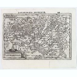
LOTHARINGIA Ducatus.
Map of Lorraine, with Metz, Sarbrucken, etc. The map first appeared in 1585. In 1604, the copperplates for the atlas were sold to Jodocus Hondius and Cornelis Claesz. In ...
Date: Duisburg and then Amsterdam, (1585) 1613
Selling price: ????
Please login to see price!
Sold in 2013
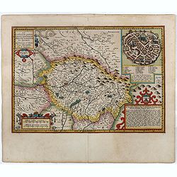
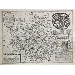
TOTIUS LEMOVICI ET Confinium ... Petrus Kaerius caelavit.
A map of Limousin/Limoges, prepared by the well-known engraver, Petrus Kaerius. With an insert view of Limoges at top right. An attractive, finely engraved map.Jodocus ...
Date: Duisburg and then Amsterdam, (1607-08) 1613
Selling price: ????
Please login to see price!
Sold in 2013
Region of Paris: L\'Isle de France PARISIENSIS AGRI DESCRIPTIO Auctore F. Guilloterio Biturigi.
This is a fine, early map of the Ile de France and the area surrounding Paris. The map has considerable details of the towns and villages in the region. The title carto...
Date: Duisburg and then Amsterdam, (1606) 1613
Selling price: ????
Please login to see price!
Sold in 2011
Gallia / Per Gerardum Mercatorem.
An early map of France by Gerard Mercator.Gerard Mercator (1512-1594) was one of the most famous geographers of his time. He was renowned as a scholar in his day, and hi...
Date: Druisburg and then Amsterdam, 1613
Selling price: ????
Please login to see price!
Sold in 2012
Alsatia Superior cum Suntgoia & Brisgoia Per Gerardum Mercatorem.
Finely engraved map of the Alsace region of France with Germany & Switzerland. The map focuses on the course of the Rhine River from Basel to Strasbourg. North is o...
Date: Duisburg and then Amsterdam, (1585-95) 1613
Selling price: ????
Please login to see price!
Sold in 2013
ALSATIA inferior Per Gerardum Mercatorem
Finely engraved and attractive map of the Alsace region of France with Germany. The map shows the course of the Rhine River around Strasbourg. North is oriented to the ri...
Date: Duisburg and then Amsterdam, (1585-95) 1613
Selling price: ????
Please login to see price!
Sold in 2013
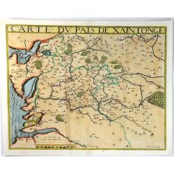
Carte Du Pais De Xaintonge.
A pleasing map of Poitiers. (Xaintonge). It was one of the earliest maps of the region. Detailed with the sea engraved with a 'moiree' effect and the forests, villages an...
Date: Paris, 1616
Selling price: ????
Please login to see price!
Sold in 2016
Provence.
Text in Latin on verso.
Date: Amsterdam 1616-1618
Selling price: ????
Please login to see price!
Sold in 2011
Provence.
A detailed miniature map of the Provence including Nice, Ventimiglia, Cannes, Toulon, Marseille, Orange, Avignon, and many more. Latin text on verso.
Date: Amsterdam, ca 1618
Selling price: ????
Please login to see price!
Sold in 2018
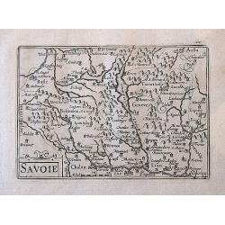
Savoie.
A delightfully small, but very detailed map including the cities of Geneva, Basle, Aosta, Lyon, Valence, and many more.
Date: Amsterdam, ca. 1618
Selling price: ????
Please login to see price!
Sold in 2017
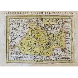
Franciae Comitatus.
A very small but attractive map of the region around Paris, with many details and place names. Latin text on verso.
Date: Amsterdam, ca. 1618
Selling price: ????
Please login to see price!
Sold in 2017
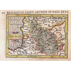
Artesia.
An nice early miniature map of Northern France and the border region of Belgium. From Dieppe to Kortrijk including Lille, Arras, Cambrai. Latin text on verso.
Date: Amsterdam, ca. 1618
Selling price: ????
Please login to see price!
Sold in 2017
Totius Lemovici.
In 1594 Francois Bougereau published his Le Theatre Francois, the first atlas of France. Jean Leclerc re-issued this atlas in 1619 as 'La Theatre geographique de France. ...
Date: Paris, 1619
Selling price: ????
Please login to see price!
Sold in 2009
Le Daulphine, Languedoc, Gacoigne, Provence. . .
A highly detailed map of southern France. The title cartouche at the top left hand corner is decorated with bunches of fruit. Rivers, mountain ranges and forests are show...
Date: Paris, 1593 - ca.1619
Selling price: ????
Please login to see price!
Sold in 2017
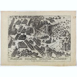
Philippus Strossy Italianischer Captein. . . Plate 26.
Early print from the series about the " Eighty-Years War" or the independence war of Holland against Spain, we know of approximately four hundred engravings by ...
Date: Cologne, ca. 1619
Selling price: ????
Please login to see price!
Sold in 2016
In disser zusammen treffung wirdt es pferdt Des Princen von Conde geschossen zu Erde. . . Plate 64.
Early print showing the killing of the horse of Henri de Bourbon Prince of Condé on 13 March 1619.Plate from the series about the " Eighty Years' War" or the i...
Date: Cologne, ca. 1619
Selling price: ????
Please login to see price!
Sold in 2021
Bolonia & Guines Comitatus.
A fine Hondius map showing a part of northwestern France. The map is oriented with west at the top and shows the French coast from Calais to Grofflieres and the Canche Ri...
Date: Amsterdam, 1619
Selling price: ????
Please login to see price!
Sold in 2020
La Beauce.
A fine Hondius map of 'La Beauce' (Northern France between Seine and Loire rivers). This maps shows the cities of: Chartres, Orleans, Blois, Paris and others, and it fea...
Date: Amsterdam, 1619
Selling price: ????
Please login to see price!
Sold in 2023
L'Isle de France Parisiesis Agri de Scriptio Auctore.
A detailed map of the region with Paris and Vincennes. It is beautifully engraved with forests, cities, villages and rivers with the compounds at Vincennes and Madril pro...
Date: Amsterdam, 1619
Selling price: ????
Please login to see price!
Sold in 2018
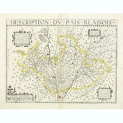
Description du pais blaisois.
Map of the center of France published by Jean Le Clerc. Detailed map shows Blois, Romorantin, Chateaudun, Vendome.Jean le Clerc was a French engraver, bookseller and publ...
Date: Paris, 1620
Selling price: ????
Please login to see price!
Sold
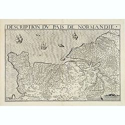
Description du Pays de Normandie.
A rare map prepared by Damien de Templeux Escuyer Sr du Frestoy. Engraved by Picquet. The sea decorated with ships and sea monsters.
Date: Paris, 1620
Selling price: ????
Please login to see price!
Sold in 2014
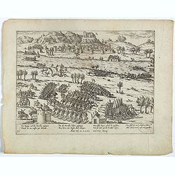
Des Kunigs vnd der Fursten regiment, Thundt hie eintreffen gar behendt . . Plate 74.
Early print showing the battle of the Rhone at Le Pouzin (Ardèche department).Plate from the series about the " Eighty Years War" or the independence war of Ho...
Date: Cologne, ca. 1620
Selling price: ????
Please login to see price!
Sold in 2023
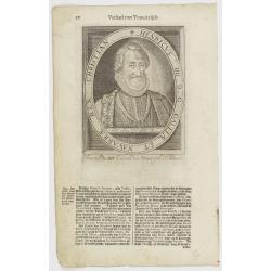
Henricus IIII. D. G. Galliae Et Navarrae Rex Christian.
The engraving depicts a half length oval portrait of Henry IV of France.Nicolaes de Clerck (de Klerc) was active as engraver and publisher in Delft from 1599-1621.Include...
Date: Amsterdam, Cloppenburch, 1621
Selling price: ????
Please login to see price!
Sold in 2010
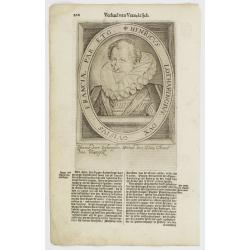
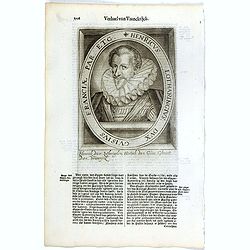
Henricus Lotharingius, Dux Guisius Franciae Par. Etc.
The engraving depicts a half length oval portrait of Henry of Lorraine, Duke of Guise.Nicolaes de Clerck (de Klerc) was active as engraver and publisher in Delft from 159...
Date: Amsterdam, Cloppenburch, 1621
Selling price: ????
Please login to see price!
Sold in 2011
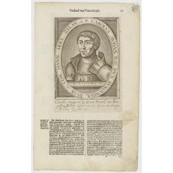
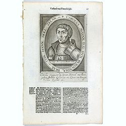
Carolus Audax D. G. Dux Burgundiae Brab. etc. Com. Hann. Holl. Zelan. etc.
The engraving depicts a half length oval portrait of Charles, Duke of Burgundy.Nicolaes de Clerck (de Klerc) was active as engraver and publisher in Delft from 1599-1621....
Date: Amsterdam, Cloppenburch, 1621
Selling price: ????
Please login to see price!
Sold in 2013
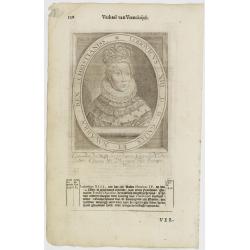
Lodovicus XIII. D. G. Galliae Et Navarrae Rex Christianiss.
The engraving depicts a half length oval portrait of Louis XIII of France.Nicolaes de Clerck (de Klerc) was active as engraver and publisher in Delft from 1599-1621.Inclu...
Date: Amsterdam, Cloppenburch, 1621
Selling price: ????
Please login to see price!
Sold in 2011
Gallia.
Small map of France, surrounded by text in Dutch. Nicolaes de Clerck (de Klerc) was active as engraver and publisher in Delft from 1599-1621.Included in the rare book : W...
Date: Amsterdam, Cloppenburch, 1621
Selling price: ????
Please login to see price!
Sold
Henricus Lotharingius, Dux Guisius Franciae Par. Etc.
The engraving depicts a half length oval portrait of Henry of Lorraine, Duke of Guise.Nicolaes de Clerck (de Klerc) was active as engraver and publisher in Delft from 159...
Date: Amsterdam, Cloppenburch, 1621
Selling price: ????
Please login to see price!
Sold in 2020
Carolus Audax D. G. Dux Burgundiae Brab. etc. Com. Hann. Holl. Zelan. etc.
The engraving depicts a half length oval portrait of Charles, Duke of Burgundy. Nicolaes de Clerck (de Klerc) was active as engraver and publisher in Delft from 1599-1621...
Date: Amsterdam, Cloppenburch, 1621
Selling price: ????
Please login to see price!
Sold in 2023
