Browse Listings in Europe
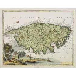
Carta Geografica del Regno di CORSICA.
Taken from In Lo stato presente di tutti i paesi, e popoli del Mondo ...Vol. XXIV, edited by Thomas Salmon. A Italian edition of this famous work, published in 26 volumes...
Date: Albizzi, Venise, 1740
Selling price: ????
Please login to see price!
Sold
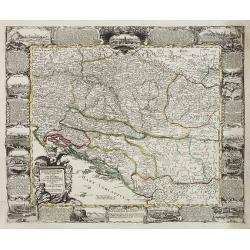
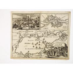
Danubii Fluminis pars media in qua Hungaria, Sclavonia..
Very rare "carte à figures" map of former Yugoslavia. With decorative title cartouche and surrounded by four borders with 13 city views each accompanied by lar...
Date: Augsburg, 1740
Selling price: ????
Please login to see price!
Sold
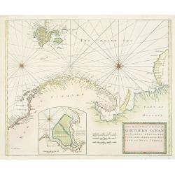
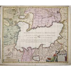
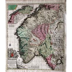
A New Generall Chart of Ye Northern Ocean vitz Norway, Greenland, Finmark, Lapland, Moscovy and Nova Zembla.
Chart of the coasts of Norway, Sweden, Lapland, Russia, including the west coast of Nova Zembla, and part of Greenland. With inset of the island of Podesemsko, with Archa...
Date: London, 1716 - 1740
Selling price: ????
Please login to see price!
Sold in 2009
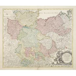
Circulus Saxoniae inferioris.
Johann Baptist Homann's well-engraved map of northern part of Germany. Including the towns of Hamburg, Berlin, Gottingen, enz. Johann Baptist Homann (1663-1724) was a Ger...
Date: Nuremberg 1740
Selling price: ????
Please login to see price!
Sold in 2022
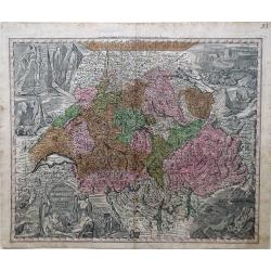
Nova Totius Helvetia cum Suis Surditis.
Matthaus Seutter map of Switzerland with vignettes of the Alps in the upper right and left corners and bottom right corner.
Date: Augsburg, 1730-1740
Selling price: ????
Please login to see price!
Sold in 2010
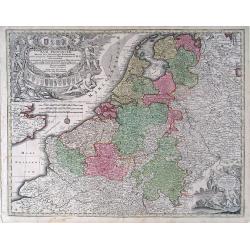
Germanie Inferioris Belgii.
Matthaus Seutter map of northern France, Belgium and Holland. Shows from Paris, France in the south to Rotterdam, Holland in the north.
Date: Augsburg, 1730-1740
Selling price: ????
Please login to see price!
Sold in 2010
XVII Provincia Belgii five Germanie Inferioris.
Matthaus Seutter map showing regions of northern France, Belgium, Holland, England and Germany.
Date: Augsburg, 1730-1740
Selling price: ????
Please login to see price!
Sold in 2010
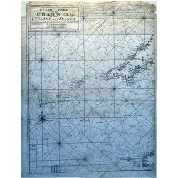
A Large Chart of The Channell Between England And France.
A striking nautical chart detailing of the channel between England and France.
Date: London, 1740
Selling price: ????
Please login to see price!
Sold in 2010
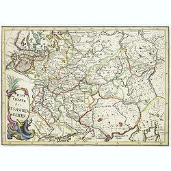
Post Charte des Russischen Reichs.
Rare map of Russia showing the postal roads. Large title cartouche in lower left corner.More about post road mapspost route maps.
Date: Germany, ca. 1740
Selling price: ????
Please login to see price!
Sold in 2010
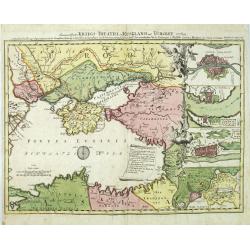
Des neueroffneten Kriegs-Theatri in Rusland und Turckey..
A rare map of the Black Sea, the scene of Russia-Turkish hostilities in 1736-9. The inset fortification plans feature Constantinople, Azov, Bendery and the strongholds at...
Date: Nuremberg 1740
Selling price: ????
Please login to see price!
Sold in 2010
Nova Totius Helvetia cum Suis Surditus ac Sociis.
Decorative map of Switzerland with vignettes of the Alps in the upper right and left corners and bottom right corner and a decorative cartouche in the lower left corner.
Date: Augsburg, 1730-1740
Selling price: ????
Please login to see price!
Sold in 2010
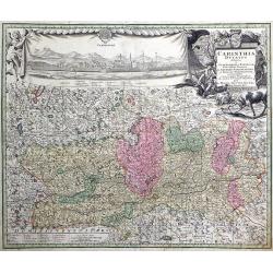
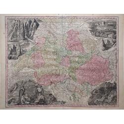
Carinthia Ducatus destineta in Superiorem, et Inferior. Cum infertis Dominiis ad Archiep Salisburgens et Episcop. Bambergensis pertinentibus nova mappa Geographica ob oculos et venum exposita per Matth. Seutter.
Decorative map of the region of the duchy of Carinthia in southern Austria bordering the eastern Alps. The map shows many details of the regions, such as mountains, abbey...
Date: Augsburg, 1730-1740
Selling price: ????
Please login to see price!
Sold in 2010
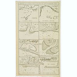
St. Sebastian. A strong fortified town of Guiapuscoa laying at the bottom of the Bay of Biscay
A very rare plan of San Sebastian in Spain by W.H. TomsThis copper engraved plan of San Sebastian was drawn by G. S. Baudwin and sold, engraved and published by W. H. Tom...
Date: London, 1740
Selling price: ????
Please login to see price!
Sold in 2010
Plan de la ville de Brusselle, Ville Noble au Duche de Brabant, et les delices des Pays Bas.
Impressive and scarce plan of Brussels by Covens & Mortier. This city plan was engraved by F. De Bakker and published in Amsterdam after 1712. The plan is a copy of t...
Date: Amsterdam, 1740
Selling price: ????
Please login to see price!
Sold in 2010
Mappae Imperii Moscovitici pars Septentrionalis.
Detailed map of northern Russia embellished with an uncolored pictorial cartouche showing hunting scenes.Good detail in Lapland, the White Sea and Archangel. St. Petersbu...
Date: Augsburg, 1740
Selling price: ????
Please login to see price!
Sold in 2010
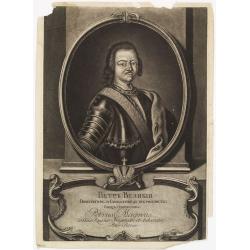
Petr Welikij imperator i camoderschez wserossinskij oschez oschetscheschewa (rossice). Petrus Magnus totius Russiae imperator et autocrator.
Mezzo tint by A. Zouboff, after J. G. Tannauer. Very rare variant of the portrait of Peter the Great with a Cristal Czar cross and crown. Another version is known where t...
Date: St. Petersburg, c. 1740
Selling price: ????
Please login to see price!
Sold in 2014
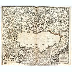
Accurater Grundriss und gegend des vestung Asoph samt der Russischen Belagerung.
A map of the Black Sea with in top a plan and siege of the town of Asoph, "Prospect und Belagerung der Vestung Asoph” and "Plan “Wahrer Grundriß der Vestun...
Date: Germany, c.1740
Selling price: ????
Please login to see price!
Sold in 2010
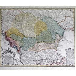
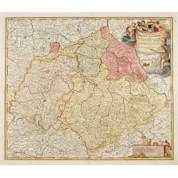
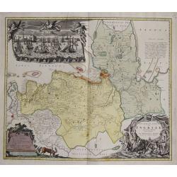
Carte d'Hongrie en general contenant felon la Division ancienne & methodique, la Hongrie en particulier, la Croatie, la Dalmatie, la Bosnie, la Servie, la Boulgarie; la Principaute de Transylvanie, les Defpotats de Walacie & de Moldav...
A fine map of the Balkan region, including Hungary, Romania, Bulgaria, Bosnia, Serbia, Macedonia and the eastern regions of the Black Sea, by Johann Matthias Haas (Hasius...
Date: Nuremberg: c.1740
Selling price: ????
Please login to see price!
Sold in 2010
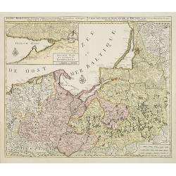
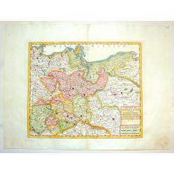
Regni Borussiae.. Royaume de Prusse. . .
Rare map of Prussia, with inset map of the area around Kaliningrad (Koningsberg), the capital of Kaliningrad region, and an exclave of White European Russia, on the Prego...
Date: Amsterdam, 1740
Selling price: ????
Please login to see price!
Sold in 2010
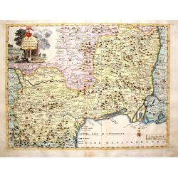
Praefectura generalis Languedociae olim Occitania.
Detailed map of Languedoc and contiguous regions. Published by Gerard and Leonard Valk.
Date: Amsterdam, 1740
Selling price: ????
Please login to see price!
Sold in 2011
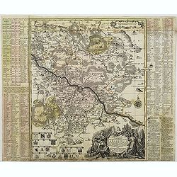
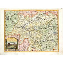
Accuratissima delineatio Geographica Dioecesis Ac Prefecture Dresdensis. . .
Detailed map centered of Dresden. Legend in the left and the right of the map. Beautiful title cartouche in the lower right corner.This edition by Seutter, another, later...
Date: Augsburg, c. 1740
Selling price: ????
Please login to see price!
Sold in 2015
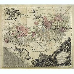
Anhaltinus Principatus Stirpis Ascaniensis felicitate hodiè florens geographi. . .
Map of Anhalt in eastern Germany, reaching from Magdeburg to Wittenberg, Halle/Saale and Quedlinburg. Large and very decorative pictorial cartouche, two further baroque c...
Date: Augsburg, 1740
Selling price: ????
Please login to see price!
Sold in 2012
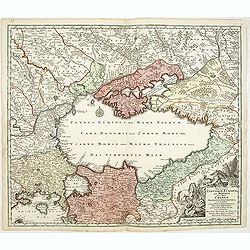
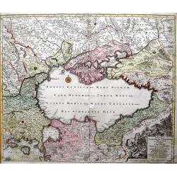
Nova et accurata Tartariae Europae seu Minoris et in specie Crimeae. . .
Rare map of the Black Sea area, showing Southern Russia, including the Ukraine, Cossack Regions and the Southern part of Muscovy, parts of Lithuania, and Poland In lower ...
Date: Augsburg, 1740
Selling price: ????
Please login to see price!
Sold in 2011
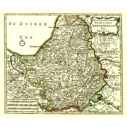
Ducatus Geldria Te Trachia Arnhemiensis Sive Velavia.
Detailed map covering Amersfoort, Elburg, Zwolle, Deventer, Zutphen, Doesburgh, Wageningen, etc.
Date: Amsterdam, 1740
Selling price: ????
Please login to see price!
Sold in 2022
Circulus Saxoniae Superioris ..
Detailed and decorative map centered Leipzig and including Dresden, Meissen, Erfurth, etc. With fine title cartouche with Hercules, putti and a fanciful view of Leipzig.
Date: Nuremberg, 1740
Selling price: ????
Please login to see price!
Sold in 2020
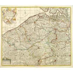
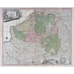
Comitatus Flandriae universe in ditiones. . .
Detailed map of Flandriae. Showing the cities of Lens, Lille, Bethune, Brugge, Gent. Beautiful title cartouche surrounded by 5 cherubs.
Date: Amsterdam, 1740
Selling price: ????
Please login to see price!
Sold in 2011
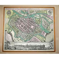
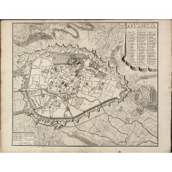
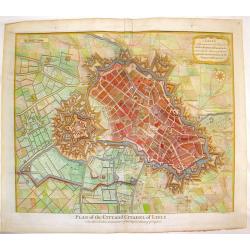
Wratislavia Antiquissima et Celeberrima Ducat. Silesiaci Metropolis ... / Breslau due Uhralte u Hochberuhmte Haupt Statt des Herzogth. Schleisien.
Large, old colored engraved town-plan of Wroclaw by Matthaus Seutter. The plan has great detailed views of individual buildings as well as explanations.In the upper corne...
Date: Augsburg, 1740
Selling price: ????
Please login to see price!
Sold in 2012
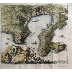
Villa Franca.
Unusual anonymous map of Villefranche-sur-Mer! Extends to Saint-Jean-Cap-Ferrat. Small but very detailed map, with fields, roads, towers, forts, etc.The title is in Frenc...
Date: Germany, c1740
Selling price: ????
Please login to see price!
Sold in 2012
Afteekening van 8 voorname havens aen de west kust van de Caspische Zee.
Detailed chart of eight important harbors at the Caspian Sea. Remarkable the highly detailed chart.Including "The Reede van Abscharon", "Zalif Bakinskaia o...
Date: Amsterdam, c. 1740
Selling price: ????
Please login to see price!
Sold in 2012
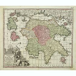
Peloponnesus Hodie Morea Ad Normam Veterum Et Recentiorum Mappa Accuratissime Adornata Aeri Incisa Et Venalis. . .
Decorative regional map of Morea and contiguous islands, with an ornate cartouche showing a lion bearing a sword defeating Turkish and other invaders.
Date: Augsburg, 1740
Selling price: ????
Please login to see price!
Sold in 2013
![Carte des isles de Majorque Minorque et Yvice : Dediée A M. le Comte de Maurepas Ministre et Secret[ai]re d'Etat Commandeur des Ordres du Roi / par N. B[ellin] Ingénieur au Dépost des Cartes et Plans de la Marine. .](/uploads/cache/30644-250x250.jpg)
Carte des isles de Majorque Minorque et Yvice : Dediée A M. le Comte de Maurepas Ministre et Secret[ai]re d'Etat Commandeur des Ordres du Roi / par N. B[ellin] Ingénieur au Dépost des Cartes et Plans de la Marine. .
Fine map of the Baleares with Minorca, Majorca, Ibiza. In lower right inset maps of a Plan of the Port of Mahon, and the western Mediterranean (showing the location of th...
Date: Paris, 1740
Selling price: ????
Please login to see price!
Sold in 2022
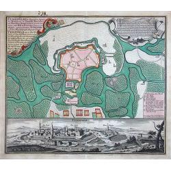
Temeswaria Oppidum superioris Hungariae. . .
Rare, large town-plan and view of the city of Timisoara, in Romania. In old original colors
Date: Augsburg, 1740
Selling price: ????
Please login to see price!
Sold in 2013

Nieuwe kaart van het hertogdom kleef. . . / Carte nouvelle du duche de Cleve. . .
Map of duchy of Cleve in northern Rhineland on both sides of the Lower Rhine river, around its capital Cleves and the town of Wesel, bordering on the lands of the Prince-...
Date: Amsterdam, 1740
Selling price: ????
Please login to see price!
Sold in 2013
Nova et Accurata Tartariae Europae seu Minoris et in specie Crimeae Deliniato Geographica...
Very detailed map of the Black Sea and the regions surrounding it, with parts of Asia Minor, Turkey, Bulgaria, Beesarabia, Ukraine and Crimea, Armenia, Georgia, etc. Wit...
Date: Augsburg, 1740
Selling price: ????
Please login to see price!
Sold in 2013
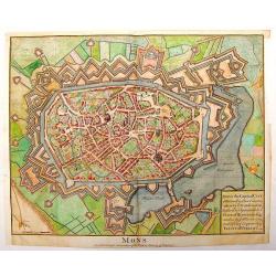
Mons, the Capital City of Hainault
City plan of Mons, Belgium during the time of the Treaty of Utrecht. From Mr. Tindal's Continuation of Mr. Rapin's "History of England".Paul de Rapin (1661-1725...
Date: Paris, 1740
Selling price: ????
Please login to see price!
Sold in 2015
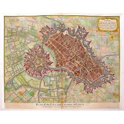
Lisle, A Strong and Rich City in the Earldom of Flanders.
Elaborate bird's-eye view of the fortifications and city if Lille and the surrounding countryside.Decorated with a title cartouche and compass rose. Paul de Rapin (1661-1...
Date: London, 1740
Selling price: ????
Please login to see price!
Sold in 2015
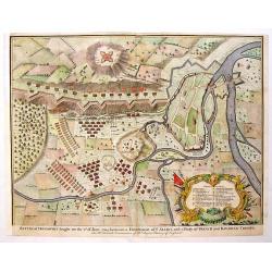
Battle of Donawert Between Allies and French & Bavarian Troops.
From Mr. Tindal's Continuation of Mr. Rapin's "History of England." Hand-colored and finely detailed with a large decorated cartouche featuring armor.Paul de Ra...
Date: London, 1740
Selling price: ????
Please login to see price!
Sold in 2013
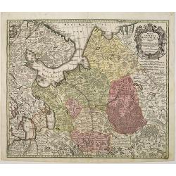
Potentissimo Borussorum Regi Friderico Wilhelmo Maiestate, Fortitudine Clementia Augustissimo Hancce Lithuaniam Borussicam : in qua luca coloniis Salisburg., ad incolendum Regio nutu concessa chorographice exhibentur D. D. D. Regiae Suae Maiestatis'
Upper part of a 2-sheet map of an area of Lithuania and Eastern Prussia (Russian province of Kaliningrad) stretching from Klaipeda (Memel) in the north to Goldap in the s...
Date: Nuremberg, ca. 1740
Selling price: ????
Please login to see price!
Sold in 2016
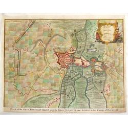
Plan of the City of Bouchaine.
"Plan of the City of Bouchain Situated Upon the Rivers Sensette & Sceld in the County of Hainault" For Mr. Tindal's Continuation of Mr. Rapin's 'HISTORY of ...
Date: London, 1740
Selling price: ????
Please login to see price!
Sold in 2015
Circolo di Sassonia Superiore ovvero Sassonia, Misnia, Voigtland, Turingia, Anhalt, Lusazia, Brandenburg e Pomerania
Interesting copper engraved map featuring the Saxony region of Germany & Poland. Decorated with a block design cartouche. Isaak Tirion (1705-1765) Dutch cartographer...
Date: Amsterdam, 1740
Selling price: ????
Please login to see price!
Sold in 2015
Carta Geografica del Governo del l\'Isola de Francia.
Fine copperplate hand-colored map of Paris and its surroundings. Features the region of Isle de France. Decorated by a splendid cartouche showing the Fontainbleau Palace....
Date: Venice, 1740
Selling price: ????
Please login to see price!
Sold in 2013
Plan of the Towm & Castle of Lerida.
Striking copperplate engraving featuring the approaches made by the French and Spanish armies during the Spanish War of Succession. Lovely Rococco cartouche. Paul de Rap...
Date: London, 1740
Selling price: ????
Please login to see price!
Sold in 2016
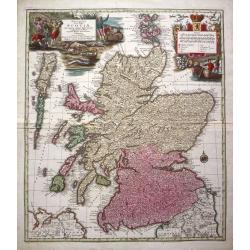
Nova et accurata totius Regni Scotiae...
From 'Atlas Novus'. A very decorative and detailed map of Scotland by Matthias Seutter who was an eminent German map-maker in Augsburg, appointed Geographer to the Imperi...
Date: Augsburg, c. 1740
Selling price: ????
Please login to see price!
Sold in 2014
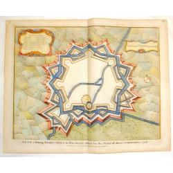
Aeth, A Strong Town in Brabant.
Fine copper engraved Fortification plan of Aeth, taken by the Duke of Marborough in 1706 during the Spanish War of Succession. Fancy Rococco cartouche. Nicholas Tindal (...
Date: London, 1740
Selling price: ????
Please login to see price!
Sold in 2016
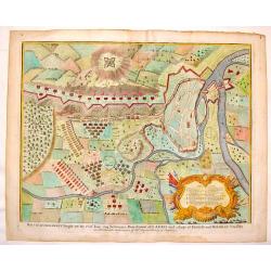
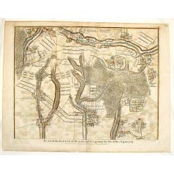
Plan of the Glorious Battle of Hochstet.
Striking hand-colored copper engraving featuring the fortifications and troop placements during the Battle of Hochstet. Lovely flag cartouche. Nicholas Tindal (1687-1774...
Date: London, 1740
Selling price: ????
Please login to see price!
Sold in 2016
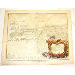
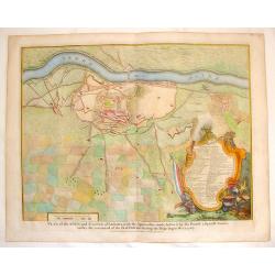
Plan of the Battle of Wynendale.
Copper engraved battle plan between Major General Webb and Count de la Motte with actual miniature pictures of the troupes. Very fancy Rococco cartouche with canons, flag...
Date: London, 1740
Selling price: ????
Please login to see price!
Sold in 2016
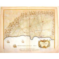
Plan of the Camp of Tarragona.
Interesting battle plan. The cartouche features Neptune and sea serpents and there are three detailed ships at sea. Nicholas Tindal (1687-1774) / Paul de Rapin (1661-172...
Date: London, 1740
Selling price: ????
Please login to see price!
Sold in 2016
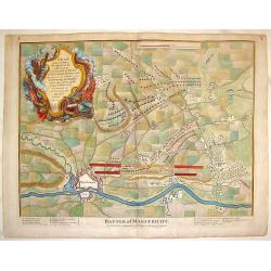
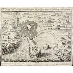
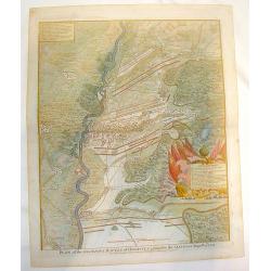
Battle of Maestricht, Plan of the Camp of the Allies.
Striking copper-engraved battle plan showing the battleground, fortifications, and troop placements during the War of the Spanish Succession. Stupendous, large, Rococo ti...
Date: London, 1740
Selling price: ????
Please login to see price!
Sold in 2014
Battle of Donawert.
Hand-colored, copper engraved map featuring the battle of Donawert. Detailed presentation of the fortifications and troops of the battle. Decorated with a fine Rococo car...
Date: London, 1740
Selling price: ????
Please login to see price!
Sold in 2016
Lisle, A Strong and Rich City in the Earldom of Flanders.
Striking bird's-eye view of the fortification of the city of Lisle. Hand-colored, copperplate, detailed map with nice title cartouche and compass rose. Nicholas Tindal (...
Date: London, 1740
Selling price: ????
Please login to see price!
Sold in 2016
Plan of the Battle of Malplaquet Gained By the Allies Sep.11, 1709.
Detailed hand-colored plan of the bloodiest battle of the 18th century, fought during the War of the Spanish Succession (1701-14). Paul de Rapin (1661-1725) was a French...
Date: London, 1740
Selling price: ????
Please login to see price!
Sold in 2016
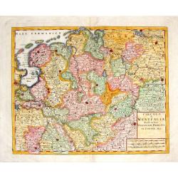
Circolo di Westfalia Diviso ne Suoi.
A detailed map of the Westfalia with portion of the Netherlands. From "Atlante Novissimo Che Contiene Tutte Le Parti Del Mondo... ." This atlas was published in...
Date: Venice, 1740
Selling price: ????
Please login to see price!
Sold in 2015
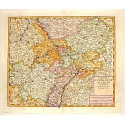
Circoli Superreed Inferred Del Reno.
A detailed map of the Alsace and Lorraine area and south west Germany and including parts of Belgium, France and Luxembourg. Includes the duties of Liege, Bonn, Frankfurt...
Date: Venice, 1740
Selling price: ????
Please login to see price!
Sold in 2015
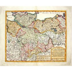
Carta del Circulo di Sassonia Inferiore.
Striking detailed map of Lower Saxony in Germany. Includes Meckelenburg, Lavenburg, Holstein, Bremen and Verden. Decorative block cartouche.From "Atlante Novissimo C...
Date: Venice, 1740
Selling price: ????
Please login to see price!
Sold in 2016
Ingermanlandiae seu Ingriae novissima tabula luci tradita.
Map shows the surrounding of St. Petersburg with a beautiful cartouche and a total view of St. Petersburg.
Date: Nuremberg, 1740
Selling price: ????
Please login to see price!
Sold in 2014
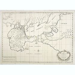
Nova et accuratissima Maris Caspii hactenus maxomam partem nobis...
Map shows the Caspian Sea and its bordering countries
Date: Augsburg, 1740
Selling price: ????
Please login to see price!
Sold in 2014
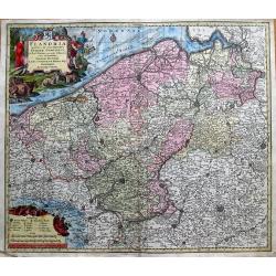
Flandria Maximus et Pulcherrimus Europae...
Large copper engraved map of Flanders in Belgium. Extends to include the borders of France, and the southern tip of the Netherlands. Shows the coastline from Grevelingen ...
Date: Augsburg, 1740
Selling price: ????
Please login to see price!
Sold in 2014
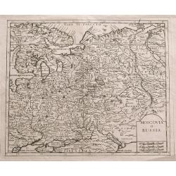
Moscovia o Russia.
Unusual map of European Russia centered on Moscow. Extends from Finland and the Baltics until Astrakhan and Crimea. A large Poland seems to extend into today's Russia. Th...
Date: Venice, 1740
Selling price: ????
Please login to see price!
Sold in 2014
Norwegiae accurata et novissima delineatione...
Seutter important map of Norway: it shows the country in great detail. Included are also small parts of Sweden. The northernmost part of Norway is delineated within an in...
Date: Augsburg, 1740
Selling price: ????
Please login to see price!
Sold in 2017
Carta Geographica del Governo della Linguadocca.
Nice hand colored map of the French Mediterranean, centered on Marseilles. Decorative cartouche of the countryside. Beautifully engraved by Giambattista Albrizzi.
Date: Venice, 1740
Selling price: ????
Please login to see price!
Sold in 2016
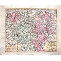
Nuova Carta del Ducatodi Lucemburgo e della Conteadi Namur.
After Isaac Tirion from "ATLATE NOVISSIMO CHE CONTIENE TUTTE LE PARTI DEL MONDO" in 1740. The publisher was Albrizzi.
Date: Venice, 1740
Selling price: ????
Please login to see price!
Sold in 2019
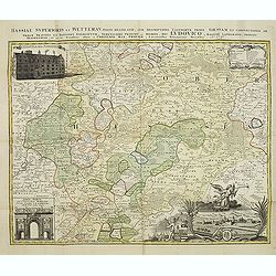
Hassiae superioris et Wetterav, partis delineatio. . .
A fine map by Homann Heirs, focusing on the Wetterau region a decorative view of Giessen and two views of buildings.
Date: Nuremberg, 1740
Selling price: ????
Please login to see price!
Sold in 2017
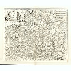
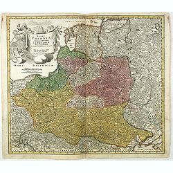
Regno di Polonia.
Detailled map of Poland, Lithuania and the Ukraine. At that time Poland covered the whole of eastern Europe from the Baltic to the Black Sea. There is very good detail th...
Date: Venice, 1740
Selling price: ????
Please login to see price!
Sold in 2015
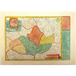
Das Marggrafthum Maehren.
Striking very detailed map of Moravia in the Czech Republic showing Brno, Austerlitz, Olomouc, Ostrava etc..It has two fancy cartouches, one with hunting and fishing scen...
Date: Leipzig, 1740
Selling price: ????
Please login to see price!
Sold in 2015
Verus Chersonesi Tauricae Seu Crimea Conspectus adjacentium item Regionem itinerisq ab Exercitu Ruthemo Ao MDCCXXXVI et MDCCXXXVII adversus Tattaros Susceptis . . .
Map of the environs of the Crimea, showing the route of the Russian Army in its expedition against the Tartars in 1736 and 1737. Showing detailed movements, including enc...
Date: St Petersburg, Academy of Sciences, 1740
Selling price: ????
Please login to see price!
Sold in 2015
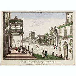
Vue du Place grande a Neaple vers Orient.
So called optical print from "Collection des Prospects" hand-colored at publication. A well-known publisher of optical prints, established in Augsburg. In the e...
Date: Augsburg, 1740
Selling price: ????
Please login to see price!
Sold in 2015
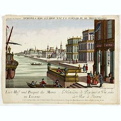
Lust-Hoff und prospect des meeres zu Livorno / L'Hotellerie de plaisance et vuë vers la mer a Livorne.
So called optical print from "Collection des Prospects" hand-colored at publication. A well-known publisher of optical prints, established in Augsburg. Engraved...
Date: Augsburg, 1740
Selling price: ????
Please login to see price!
Sold in 2015
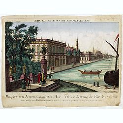
Prospect von Livorno gegen das Meer. Vuë de Livorne du Cote de la Mer.
So called optical print from "Collection des Prospects" hand-colored at publication. A well-known publisher of optical prints, established in Augsburg. Engraved...
Date: Augsburg, 1740
Selling price: ????
Please login to see price!
Sold in 2015
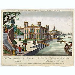
Gross Herzoglicher Lust=Hoff, zu Livorno. Pallais de Plaisance du Grand Duc de Toscane a Livorne.
So called optical print from "Collection des Prospects" hand-colored at publication. A well-known publisher of optical prints, established in Augsburg. Engraved...
Date: Augsburg, 1740
Selling price: ????
Please login to see price!
Sold in 2015
Regni Poloniae Magnique Ducatus Lithuaniae Nova et exacta tabula ad memtem Starovolcy descripta.
Fine map of Poland and Lithuania, with decorative title cartouche. Johann Baptist Homann born in Kammlach (1663). He was engraver, map-seller and geographer to the Kaiser...
Date: Nuremberg, 1740
Selling price: ????
Please login to see price!
Sold in 2016
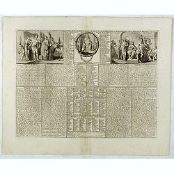
Carte des prérogatives des rois et de la noblesse d' Angleterre...
Extracted from the historical atlas: introduction to the history, chronology, ancient and modern geography, genealogy of the royal houses of Europe with descriptive Frenc...
Date: Amsterdam, 1740
Selling price: ????
Please login to see price!
Sold in 2020
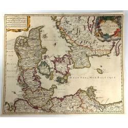
Regno Di Danimarca.
A fine map of Denmark from "Atlante Novissimo Che Contiene Tutte Le Parti Del Mondo...." This atlas was published in Venice, and was based on the work of Isaak ...
Date: Venice, 1740
Selling price: ????
Please login to see price!
Sold in 2019
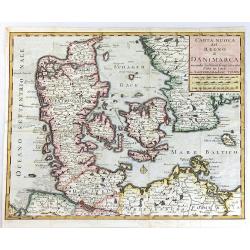
Carta Nuova del Regno di Danimarca.
A very pleasing map of Denmark that includes both Schleswig and Holstein, however, these regions are part of modern Germany today. Included in "Atlante Novissimo che...
Date: Venice, 1740
Selling price: ????
Please login to see price!
Sold in 2018
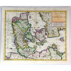
Le Royaume de Danemark Subdivisé en ses Principales Provinces...
A very attractive map of Denmark. From Schenk’s atlas “Contractus sive Mapparum Geographicarum Sansoniarum auctarum et correctarum Nova Congeries” published in Amst...
Date: Amsterdam, 1740
Selling price: ????
Please login to see price!
Sold in 2018
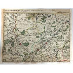
Carte Particuliere des Environs de Menin, Courtray, Ypre, Dixmude et Deynse
An engraved map of the region. Includes the cities of Menin, Courtray, Ypre, Dixmude and Deynse. The title appears above the map with the scale with the names of Covens a...
Date: Amsterdam, 1740
Selling price: ????
Please login to see price!
Sold in 2016
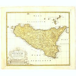
Regni & Insulae Siciliae tabula geographica. . .
Johann Baptist Homann's well-engraved map of Sicily, with a coat of arms and a large decorative title cartouche.Johann Baptist Homann (1663-1724) was a German engraver an...
Date: Nuremberg, ca. 1740
Selling price: ????
Please login to see price!
Sold in 2016
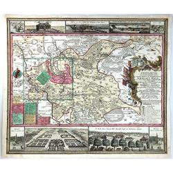
Geographische Abzeichnung der Dioeces Grossen Hayn ...
Geographische Abzeichnung der Dioeces Grossen Hayn … Beautiful historical map of the electorate Saxony diocese of Grossen Hayn. Produced by Matthäus Seutter in 1740. ...
Date: Nuremberg, ca. 1740
Selling price: ????
Please login to see price!
Sold in 2021
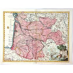
Carta Geografica del Governo di Guienna e Guascogna
A map of South Western France from "Atlante Novissimo che Contiene Tutte le Parti del Mondo". The map shows the region from La Rochelle, south to the Pyrenées ...
Date: Venice, 1740
Selling price: ????
Please login to see price!
Sold in 2016
Nova et accurata Tartariae Europae seu Minoris et in specie Crimeae. . .
Rare map of the Black Sea area, showing Southern Russia, including the Ukraine, Cossack Regions and the Southern part of Muscovy, parts of Lithuania, and Poland In lower ...
Date: Augsburg, 1740
Selling price: ????
Please login to see price!
Sold in 2016
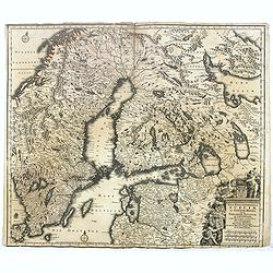
Nova mappa geographica Sueciae ac Gothiae regna ut et Finlandiae Ducatum ac Lapponia. . .
Standard map showing Sweden, Norway, Finland and surrounding countries. The copper plate was later on used by T.Lotter.
Date: Nuremberg, ca. 1740
Selling price: ????
Please login to see price!
Sold in 2016