Browse Listings in Europe
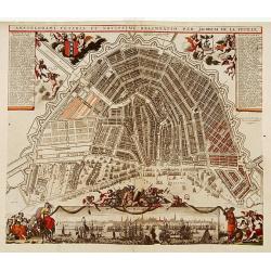
Amstelodami Veteris et Novissimi Delineatio..
A rare contemporary colored town-plan of Amsterdam with a panoramic inset view of the harbour and city. Jacob de la Feuille (1668-1719) was mapmaker, engraver and publish...
Date: Amsterdam 1706
Selling price: ????
Please login to see price!
Sold
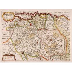
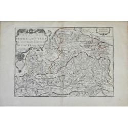
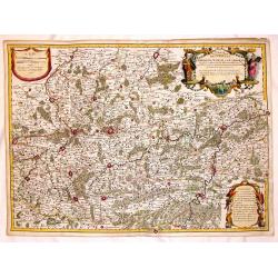
La Mayerie de BOLDVC, autrement dict Bois le Duc.
From his atlas Oorlogs tablessen, Oft uytgesochte Kaarten. Covering the so-called area Meierij van 's-Hertogenbosch. Eindhoven in the centre of the map.
Date: Amsterdam 1706
Selling price: ????
Please login to see price!
Sold
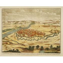
A view of Casal...
Decorative view of the italian city of Casal. engraved by J. Basire.
Date: London, 1706
Selling price: ????
Please login to see price!
Sold
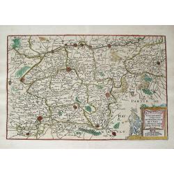
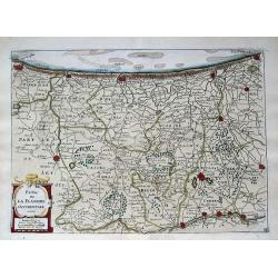
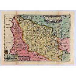
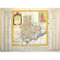
La Flandre Gallicane, Comprennant Le Chastellenie...
Small but very detailed map of the French and Belgian border region, with the fortified cites of Douai, Lille, Courtray, and Tournai. The map is embellished with an attra...
Date: Amsterdam, c1706
Selling price: ????
Please login to see price!
Sold in 2013
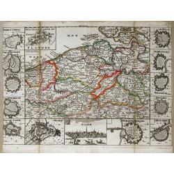
Partie de la Flandre Occidentale. . .
Very detailed map of western Flanders between Calais, Dunkerque, Omer, Ypres and Oostende. Shows many even smallest villages, roads, canals, settlements and fortification...
Date: Amsterdam, c1706
Selling price: ????
Please login to see price!
Sold in 2013
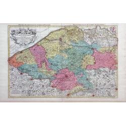
Nouvelle carte du Comte de Flandre.
A detailed map of the county of Flanders stretching from Dunkirk to the Schelde estuary. Surrounding the map are twelve towns plans: Berg St. Vinoc, Dendermonde, Ostende,...
Date: Amsterdam, 1706
Selling price: ????
Please login to see price!
Sold in 2013
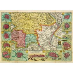
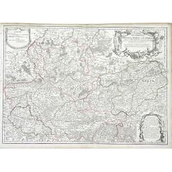
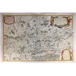
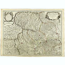
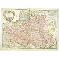
Kaart van 't Hertogdom Brabant.
From his atlas Oorlogs tablessen, Oft uytgesochte Kaarten. Covering the Dutch and Belgium province of Brabant and Limburg.Surrounded by 13 plans of the towns of 's-Hertog...
Date: Amsterdam 1706
Selling price: ????
Please login to see price!
Sold
![La Bretagne diviseé en ses neuf eveschés qui font aussi [. . .] generalité de Nantes. . .](/uploads/cache/25301-250x250.jpg)
La Bretagne diviseé en ses neuf eveschés qui font aussi [. . .] generalité de Nantes. . .
A large and most beautifully colored title cartouche with coats of arms: a very decorative map, engraved by Cordier. The map is dedicated to Pontchartain.The uncommon thi...
Date: Paris, 1706
Selling price: ????
Please login to see price!
Sold in 2008
Partie du Briançonnois, du Graisivaudan, du Gapençois et l'Ambrunois dans le Dauphiné.
Map of the Dauphiné region in France.
Date: Paris, 1706
Selling price: ????
Please login to see price!
Sold in 2009
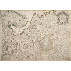
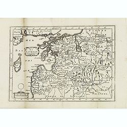
Carte de Moscovie.
Map of northwest region of Russia, including Russian Lapland and the White Sea, with a decorative cartouche in the upper right corner.
Date: Paris, 1706
Selling price: ????
Please login to see price!
Sold in 2010
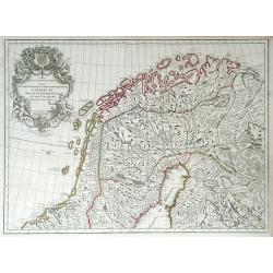
Carte des Courones du Nord Dediee Autres Puissant et tres Invincible Prince Charles XII Roy de Suede, des Gots et des Vandales
This is the top half of a two-part map of the larger Scandinavia/Russia region. This detailed map depicts Norway, Sweden, and Finland's northern areas and the Gulf of Bot...
Date: Paris, 1706
Selling price: ????
Please login to see price!
Sold in 2010
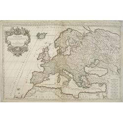
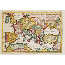
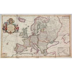
L'Europe divisee suivant l'estendue de ses principaux estats. . .
Fine map of Europe with a decorative title and scale cartouche. Prepared by Nicolas Sanson.Published by Alexis-Hubert Jaillot (1632-1712), who was a French cartographer. ...
Date: Paris, 1706
Selling price: ????
Please login to see price!
Sold in 2011
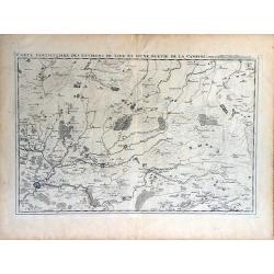
Carte Particuliere des Environs de Lier et d'Une Partie de la Campine.
Interesting map of the region of northern Belgium surrounding the town of Lier, including the Walloon region of La Bruyere (Bruyere) and part of the Campine region of nor...
Date: Brussels, 1706
Selling price: ????
Please login to see price!
Sold in 2010
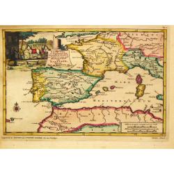
La Castille Vieiele et Nouvelle L'Estramadura De Castille Et De Leon. . .
Beautiful, detailed map of the Leon and Castille regions of Spain by Nicholas de Fer. The cities of Madrid and Toledo are depicted, as well as the mountains, forests, riv...
Date: Paris, 1706
Selling price: ????
Please login to see price!
Sold in 2010
Carte des Comtez de Hainaut de Namur et de Cambresis. . .
Finely detailed map of the Walloon region, the regions of Hainaut, Namur and Cambresis, of southern Belgium by Guillaume de L'Isle. Cities, villages, rivers, forests and ...
Date: Paris, 1706
Selling price: ????
Please login to see price!
Sold in 2010
Norrkiöping.
Rare view of Norrköping in Sweden, with its "Star Fort" before it was destroyed during the Russian attack in 1719. Published by Erik Dahlberg. Highly detail...
Date: Stockholm, 1706
Selling price: ????
Please login to see price!
Sold in 2012
La Livonie. . .
A detailed map of Latvia and Estonia, centered on Riga. From his "Atlas Portatif, ou le nouveau Theatre de la Guerre en Europe, Contenants les cartes geographiques, ...
Date: Amsterdam, 1706
Selling price: ????
Please login to see price!
Sold in 2012
Carte des Comtez de Hainaut de Namur et de Cambresis.
Pleasing copper engraved, hand-colored map of Belgium and France featuring the cities of Douai, Landrecy, Namur, Brussels and Mons. Three decorative figural cartouches wi...
Date: Paris, 1706
Selling price: ????
Please login to see price!
Sold in 2016
Carte des Comtez de Hainaut de Namur et de Cambresis.
Striking copper engraved, hand-colored map of Belgium and France, featuring the cities of Douai, Landrecy, Namur, Brussels , Valencienes, and Mons.There are three decorat...
Date: Paris, 1706
Selling price: ????
Please login to see price!
Sold in 2018
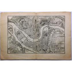
Lion, Ville Tres Considerable du Royaume.
This bird's-eye plan of Lion (Lyon) and vicinity illustrates the strategic position of its fortifications on the Saône and the Rhône rivers.It provides an excellent vie...
Date: Paris, 1706
Selling price: ????
Please login to see price!
Sold in 2019

Citta Della Di Tournay.
The City of Tournay. This plate shows the fortifications of the Belgian city of Tournai (Doornik). The plate originates from 'Teatro della Guerra' by Coronelli in 1706.Vi...
Date: Venice, 1706
Selling price: ????
Please login to see price!
Sold in 2018
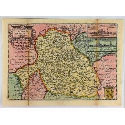
Le Comte de Haynault.
An interesting map of Haynault first drawn by Daniel de la Feuille in 1706. With ornamental title-cartouche, coat-of-arms and 2 views of the cities of Mons and Valencienn...
Date: Paris, 1706
Selling price: ????
Please login to see price!
Sold in 2018
Le Comte D'Artois.
An interesting map of Artois. France, first drawn by Daniel de la Feuille in 1706. With ornamental title-cartouche, title cartouche and view of the city of Abras. From �...
Date: Paris, 1706
Selling price: ????
Please login to see price!
Sold in 2019
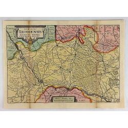
Diocesis Leodiensis Accurata Tabula.
A stunning map of Leodiensis, or the vicinity of Liege, Belgium, first drawn by Daniel de la Feuille in 1706. It depicts from Hoey in the west, eastwards as far as Peer, ...
Date: Paris, 1706
Selling price: ????
Please login to see price!
Sold in 2018
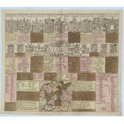
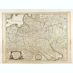
Germaniae Compendium Tria Continens Imperii Collegia. . .
An engraved chart listing the noble families and clergy of Germany, published by Schenk. The chart includes 15 large coats of arms of kings, bishops, dukes and counts, 20...
Date: Amsterdam, 1706
Selling price: ????
Please login to see price!
Sold in 2018
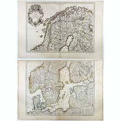
![Carte des Courones du Nord. [2 sheets]](/uploads/cache/41938-250x250.jpg)
Carte des Courones du Nord. [2 sheets]
Two-sheet map of Denmark, Sweden, Finland and the Baltic states with the address : "Carte des Courones du Nord. Chez l’Auteur, Rue des Canétes prés St. Sulpice. ...
Date: Paris, 1706
Selling price: ????
Please login to see price!
Sold in 2025
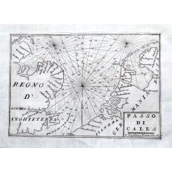
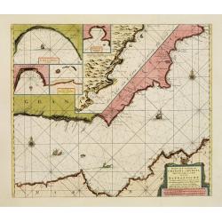
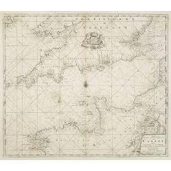
Passo di Cales.
A scarce sea-chart of the Southern Bight of the North Sea with parts of the Netherlands, Belgium, and Great Britain. With main coastal cities shown and many depth soundin...
Date: Venice, 1706
Selling price: ????
Please login to see price!
Sold in 2018
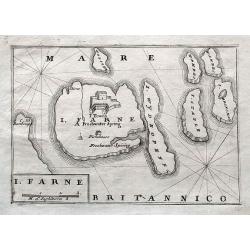
I. Farne.
A scarce map of the Farne Islands which are located off the coast of Northumberland! Published in Isole Britanniche. An apparently quite rare map, we can not find any oth...
Date: Venice, 1706
Selling price: ????
Please login to see price!
Sold in 2018
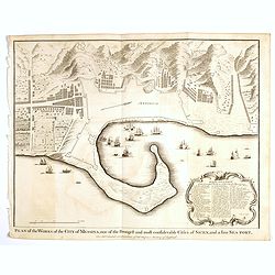
Plan of the Works of the city of Messina . . .
Fine bird's-eye plan of the city Messina. A decorative cartouche encloses a detailed key to the map that locates the castle, bastillon, armaments and government building...
Date: London, 1706
Selling price: ????
Please login to see price!
Sold in 2023
![Antique map of Scandinavia] Carte des Courones du Nord.](/uploads/cache/82019-250x250.jpg)
Antique map of Scandinavia] Carte des Courones du Nord.
[Antique map of Scandinavia] 'Carte des Courones du Nord', by Guillaume de l' Isle (1675-1724), a Royal Geographer. He was the most influential cartographer of the first ...
Date: Paris, 1706
Selling price: ????
Please login to see price!
Sold in 2020
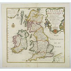
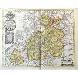
Les Isles Britanniques ou se trouvent Les Royaumes d'Angleterre, d'Ecosse et d'Irlande. . .
A nice, scarce large scale map of the British Isles by de Fer, published in Paris at the beginning of the 18th century. Outline color highlight the old Saxon, pre Norman ...
Date: Paris, 1706
Selling price: ????
Please login to see price!
Sold in 2020
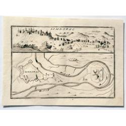
LIMBURGO.
An interesting simple city scene and map. This plate shows a view and a ground plan with fortifications of the Belgian city of Limbourg (Limburg). Vincenzo Coronelli (165...
Date: Venice, 1706
Selling price: ????
Please login to see price!
Sold in 2023
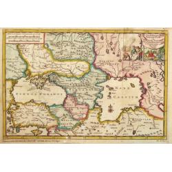
De Landschappen der Percoptize en Nogaize Tartars, Circassen, Mingrebilianen en Georgianen met die vande Crim
Pieter van der Aa was a prolific publisher. He published a.o. 'Naaukeurige versameling der gedenkwaardigste zee- en land-reysen', a series of accounts of voyages (1706-08...
Date: Leiden, 1707
Selling price: ????
Please login to see price!
Sold in 2009
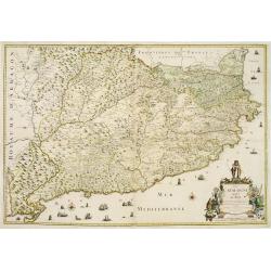
La Catalogne Dédiée au Roy..
A scarce map of Catalonia showing the coastline from Perpignan until the province of Valencia. Extensive shipping and a large title cartouche.Published by Mademoiselle Du...
Date: Paris, 1707
Selling price: ????
Please login to see price!
Sold
d\' Avontuurlyke Reystogt van Johan Smith uit Engeland, over zee en land, na Duitsland, Italien, en Barbarye, tot in Turkye en Tartaryen.
Pieter van der Aa was a prolific publisher. He published a.o. "Naaukeurige versameling der gedenkwaardigste zee- en land-reysen", a series of accounts of voyage...
Date: Leiden, 1707
Selling price: ????
Please login to see price!
Sold in 2017
Reys-Weg uit Brabant?Spanje en Portugal.
Pieter van der Aa was a prolific publisher. He published a.o. ' Naauwkeurge versameling der gedenkwaardigste zee- en land-reysen', a series of accounts of voyages (1706-0...
Date: Leiden, 1707
Selling price: ????
Please login to see price!
Sold in 2016
Constantinopelen en Egypten door Nicolaus Schmidt . . . Besogt.
A map of the eastern part of the Mediterranean illustrating the voyage made by Nicolaus Schmidt. Embellished with an attractive title-cartouche.Pieter van der Aa was a pr...
Date: Leiden, 1707
Selling price: ????
Please login to see price!
Sold in 2017
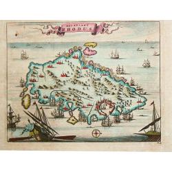
Het Eylant Rhodus.
Pieter van der Aa was a prolific publisher. He published a.o. "Naaukeurige versameling der gedenkwaardigste zee- en land-reysen", a series of accounts of voyage...
Date: Leiden, 1707
Selling price: ????
Please login to see price!
Sold in 2017
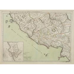
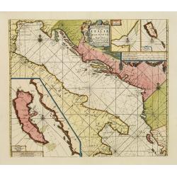
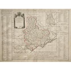
Regionum Italiae mediarum Tabula Geographica..
Fine historical map of central Italy with Tuscany and centered on Rome, in the south Pompeii, in top the island of Giglio and the town Orbetello. Lower left inset plan of...
Date: Paris, 1707
Selling price: ????
Please login to see price!
Sold in 2022
Carte du Piemont et du Monferrat.
This is the top section of a separately published two sheet map of The Alps region of France and Italy. Shows the regions of Savoy in France and Piedmont in Italy, and in...
Date: Paris, 1707
Selling price: ????
Please login to see price!
Sold in 2010
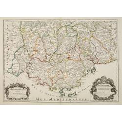
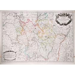
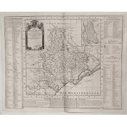
LA PROVENCE Divisée en ses Vigueries et Terres Adjacentes.
Detailed map of southern France. Showing the cities of Marseille, St.Tropez, Cannes, Nice, Antibes, Aix, Orange, Barcelonette, Senez., and Monaco, etc.Detailed map by one...
Date: Paris, 1707
Selling price: ????
Please login to see price!
Sold
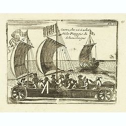
Carro, che uà à vela Su le Piagge di Schevelingue.
Italian version of Prince Maurits' sailing carriage designed by Simon Stevin. The big sailing-carriage could seat 28 persons and could reach a speed of seven miles per ho...
Date: Venice, 1707
Selling price: ????
Please login to see price!
Sold in 2012
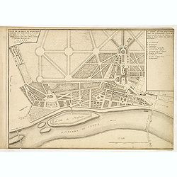
Plan de la belle et magnifique maison de Monsieur à St Cloud. . .
Garden plan in St. Cloud near Paris.
Date: Paris, 1707
Selling price: ????
Please login to see price!
Sold in 2013
La Lorraine.
Alexis-Hubert Jaillot (1632-1712), French cartographer. he joined the Sanson heirs. He redrew Nicolas Sanson's maps on a larger scale. 'Atlas Nouveau' (1674), sea-atlas '...
Date: Paris, 1707
Selling price: ????
Please login to see price!
Sold in 2019
Carte du Piemont et du Montferrat.
Map of Piemont and Montferrat in Italy with the imprint " Chez l’Auteur sur le Quai de l’Horloge (address erased after Horloge). Avec Privilege, Avril 1707. Se t...
Date: Paris, Avril 1707
Selling price: ????
Please login to see price!
Sold in 2018
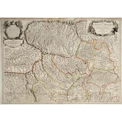
Ducatus Silesiae Glogani vera Delineatio. . .
An unusual and very attractive map of the area around Glogau (Głogów) in Poland. Highly detailed and showing many small villages, rivers, hills, and lakes. The ...
Date: Amsterdam, ca. 1707
Selling price: ????
Please login to see price!
Sold in 2020
Vues des villes de Londres, de Canterbury, de Colchester, et autres Lieux circonvoisins. - II. ... Vues des villes, edifices & autres choses remarquable de l'Escosse & d'Irlande. - III. and IV
Four books in one, printed Chez Pierre vander Aa, Leyden, Netherlands. Beautiful, very rare plate book of Great Britain in 6 parts with a total of 25 maps, and 216 pla...
Date: Leyden, 1707
Selling price: ????
Please login to see price!
Sold in 2023
Pascaart van de Zee Kusten van Granada en Murcia.. Barbarische Zee-Kusten..
This sea chart covers the Spanish coast from Véléz-Malaga, in the region Andalucía, from Malaga as far as Alicante and Bay of Altea, in the province of Valencia. It sh...
Date: Amsterdam, 1708
Selling price: ????
Please login to see price!
Sold
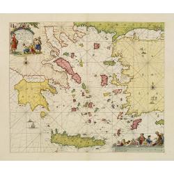
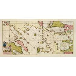
Pascaerte Vande Archipel en de Eylanden.. Candia.. Natolia..
This sea chart covers the Mediterranean coast between the Peloponnese, in Greece, and the Turkish coast facing Rhodes.It is centred in the Aegean Islands and shows Crete ...
Date: Amsterdam, 1708
Selling price: ????
Please login to see price!
Sold
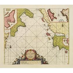
Pas kaart Vande Zee-kusten van Cicilia, Calabria, Graetia en Morea. . .
This sea chart covers the Mediterranean coast between the coast near Syracuse, in Sicily, and the Kythera island (also known as Cerigo), in Greece.It is centred in the Io...
Date: Amsterdam, 1708
Selling price: ????
Please login to see price!
Sold in 2020
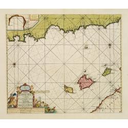
Paskaart, Voor een Gedeelte der Kust van, Barbaria.. Catalonia.. Yvica, Majorca, en Minorca..
This sea chart covers the Algerian coast in front of the Balearic Islands, South on top. Shows the 4 Balearic Islands (Majorca, Minorca, Ibiza) and part of the Catalonian...
Date: Amsterdam, 1708
Selling price: ????
Please login to see price!
Sold
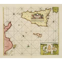
Nieuwe Paskaart van de Zeekusten van 't Eylandt Sicilia..
This sea chart covers the area of the Mediterranean Sea between Italy and the Tunisian coast. Including the islands of Sicily and Malta in the center of the chart. fIt co...
Date: Amsterdam, 1708
Selling price: ????
Please login to see price!
Sold
Pascaart vande Weder zytsche Zee-kusten soo van Italia als Dalmatia..
Centred off the Gargano cape, this sea chart covers the coast surrounding the Adriatic Sea between Italy and the first Greek Islands. It contains an 3 enlarged inset plan...
Date: Amsterdam, 1708
Selling price: ????
Please login to see price!
Sold
Paskaart Van de Archipelagusche Eylanden..
This sea chart represents the Northern Aegean Islands. It contains an enlarged inset map of the eastern coast of the Chios island as well as one of the gulf of Smyrna, in...
Date: Amsterdam, 1708
Selling price: ????
Please login to see price!
Sold
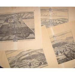
16 plates of English castles and houses.
16 very finely engraved and detailed bird's-eye views of the great English country houses, showing the architecture, formal gardens, and the surrounding landscape.The pla...
Date: London, 1708
Selling price: ????
Please login to see price!
Sold
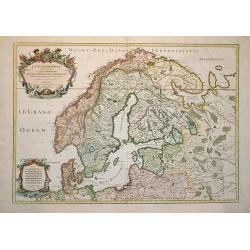
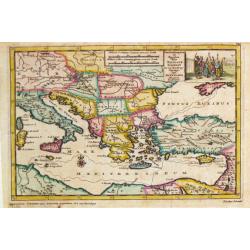
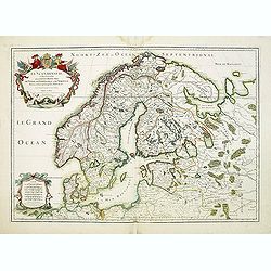
La Scandinavie et les Environs où sont les Royaumes.
Fine map of Scandinavia and the Baltic States with figurative armorial cartouche and small scale of miles. Engraved by Cordier.
Date: Paris, 1708
Selling price: ????
Please login to see price!
Sold in 2009
Le Comte de Flandre Divis en ses Chastellenies e Balliages?
Nicolas Sanson map of Belgium published by the Mortier publishing firm in Amsterdam with vibrant original color.
Date: Amsterdam, 1696-1708
Selling price: ????
Please login to see price!
Sold in 2010
Carte du Diocese de Beziers.
Map of the Beziers and Languedoc regions of southwestern France by French cartographer de L'Isle. Includes indexes on both sides of the map, and a decorative cartouche in...
Date: Paris, 1708
Selling price: ????
Please login to see price!
Sold in 2010

La Scandinavie et les Environs où sont les Royaumes.
Fine map of Scandinavia and the Baltic States with figurative armorial cartouche and small scale of miles. Prepared by Sanson and published by Hubert Jaillot.Engraved by ...
Date: Paris, dated 1708
Selling price: ????
Please login to see price!
Sold in 2010
Nieuwe Wassende Graave Paskaart van't Canaal Tussen Engelandt en Vrankryk. . .
Chart showing the west cost of France and the south coast of England. Decorative cartouche lower right.
Date: Amsterdam, c.1708
Selling price: ????
Please login to see price!
Sold in 2010
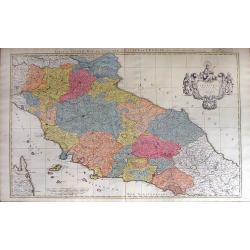
Estat du Grand Duc de Toscane, & Estats de L'Eglise / Estats de L'Eglise, et de Toscane. . .
A beautiful, large scale map of Tuscany, and the surrounding regions including the island of Elba and part of Corsica by Nicholas Sanson and published by Pierre Mortier. ...
Date: Amsterdam: 1696-1708
Selling price: ????
Please login to see price!
Sold in 2010
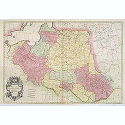
Estats de la couronne de Pologne subdivisés suivant l'estendue des palatinats. . .
Decorative and detailed map of Poland, with tip of the Black Sea lower right. Prepared by Sanson, but published by Hubert Jaillot. Engraved by Cordier. A scarce map.
Date: Amsterdam, 1708
Selling price: ????
Please login to see price!
Sold in 2012
La Scandinavie et les Environs où sont les Royaumes.
Fine map of Scandinavia and the Baltic States with figurative armorial cartouche and small scale of miles. Prepared by Sanson and published by Hubert Jaillot.Engraved by ...
Date: Paris, dated 1708
Selling price: ????
Please login to see price!
Sold in 2012
Poland Corrected from the Observations Communicated to the Royal Society at London and the Royal Academy at Paris . . .
A two sheet map of Poland, one of the largest maps of Poland ever to appear in an English Atlas. The map extends from the Baltic, Silesia and Hungary in the West to Biela...
Date: London, 1708
Selling price: ????
Please login to see price!
Sold in 2013
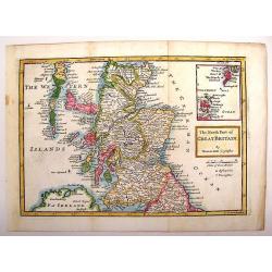
The North Part of Great Britain.
Interesting map of northern Great Britain (Scotland). It has an inlay of the Shetland and Orkney Islands. Herman Moll (1654 – 1732), was a cartographer, engraver, and ...
Date: London, 1708
Selling price: ????
Please login to see price!
Sold in 2013
Carte du Diocese de Beziers.
An important early map of South Western France featuring the region of Languedoc that occuties a portion of the French Riviera. The top right corner features a town plan ...
Date: Amsterdam, 1708
Selling price: ????
Please login to see price!
Sold in 2015
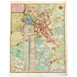
Bourg, Chateau et Jardins de Fontaine-Blaeu.
A striking plan view of Fontainebleau, a one-time Royal residence near Paris. The plan has three cartouches, and a splendid compass rose. Signed in print by C. Inselin. N...
Date: Paris, 1708
Selling price: ????
Please login to see price!
Sold in 2013
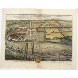
Swillington in the West Rideing of Yorkshire, the Seate of William Louther, Esq.
Fine hand-colored bird's-eye view of the great country house of Swillington. It shows the architecture, formal gardens, and the surrounding landscape. Drawn by Leonard Kn...
Date: London, 1708
Selling price: ????
Please login to see price!
Sold in 2019
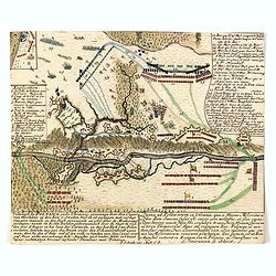
Veltslagh by Poltawa inde Ukrainie, gewonnen door den Czaar van Moskovie op den Kon. v. Sweden . . . / Pugna ad Poltawan in Ukrainia. . .
Detailed engraving of the Siege of Poltawa in Ukraine. Published in "Schouwburg van den oorlog, beginnende van koning Karel den II. tot op Koning Karel den III"...
Date: Amsterdam, after 1708
Selling price: ????
Please login to see price!
Sold in 2015
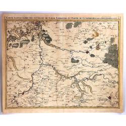
Carte Particuliere des Environs de Liege, limbourg et Partie de Luxembourg
A fine map of parts of Germany and Luxembourg by Eugene Henry Fricx in Brusselles in 1708. Published by Covens & Mortier. The map details cities, villages, forests an...
Date: BRUXELLES, 1708
Selling price: ????
Please login to see price!
Sold in 2016

Assemblée générale de la Diette de l'Empire et l'ordre de la séance de ses différents colleges.
Interesting sheet with an illustration of the progress of the Diette of the German Empire, with descriptive French text, from Chatelain's monumental 7 volume 'Atlas Histo...
Date: Amsterdam, 1708
Selling price: ????
Please login to see price!
Sold in 2017
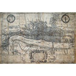
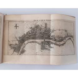
A Plan of London, Westmr. and Southwark wth ye Rivr Thames...
Hatton's famous edition of Braun & Hogenberg's view of London, first published in 1572. Shows the city in a detailed birds-eye perspective. Numerous buildings, roads,...
Date: London, 1708
Selling price: ????
Please login to see price!
Sold in 2016
Carte des Courones du Nord.
Denmark, Sweden, Finland and the Baltic states are included.
Date: Amsterdam, 1708
Selling price: ????
Please login to see price!
Sold in 2016
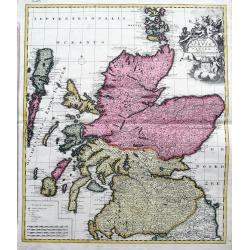
Novissima Regni Scotiae Septentrionalis et Meridionalis. . .
A rare and decorative double-page map of Scotland and its islands. Includes a wealth of place names, and extends until the Picts Wall near Carlisle. With bright original ...
Date: Amsterdam, 1708
Selling price: ????
Please login to see price!
Sold in 2018
La Pologne Dressée sur ce qu'en ot donné Starovolsk, Beauplan, Hartnoch. . .
Scarce and 2nd state of the map of Poland with the imprint "a la Courone de Diamans" : "La Pologne. Chez l’Auteur sur le Quai de l’Horloge a la C. ne d...
Date: Paris, 1707/1708
Selling price: ????
Please login to see price!
Sold in 2023
To Her Most Sacred Majesty Ann, Queen of Great Britain, France and Ireland, This Map of Europe. . .
A striking large format map of Europe, published by Herman Moll in his "New and Compleat Atlas", first published in 1708. This is from the early edition bearing...
Date: London, 1708
Selling price: ????
Please login to see price!
Sold in 2018

Novigrad.
An unusual panoramic view of Novigrad, Croatia. The view shows the city with his buildings, churches, town walls, Castle and surrounding landscape. In the foreground the...
Date: Paris, 1708
Selling price: ????
Please login to see price!
Sold in 2019
Carte du Diocese de Beziers ...
Beautiful copper engraved map of the diocese of Béziers, France, drawn up on the spot by Gautier, engineer and architect of the province of Languedoc, and dedicated to C...
Date: Paris, 1708
Selling price: ????
Please login to see price!
Sold in 2019
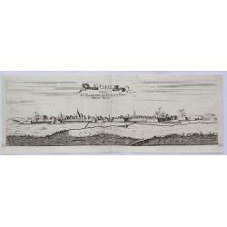
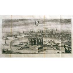
Stenay Dedic All' Illustrissimo Sig Bertuccio Valier Patritio Veneto.
A detailed copper engraved panoramic view of Stenay, a commune in the Meuse department in Grand Est in north-eastern France. The view shows the city with his buildings, c...
Date: Venice, 1708
Selling price: ????
Please login to see price!
Sold in 2021
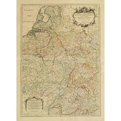
Le Cours de la Riviere du Rhein depuis sa Sources jusques a son Emboucheure ou sont distingues Tous les Etats et Souverainetes?
Handsome map detailing the course of the Rhine River, from its source in Switzerland, through Germany to its mouth on the North Sea, in the Netherlands. Also shows part o...
Date: Paris, 1709
Selling price: ????
Please login to see price!
Sold in 2016