Browse Listings in Europe
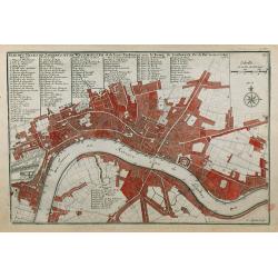
Plan des Villes de Londres et de Westminster et de leurs Faubourgs avec le Bourg de Southwark.
A rare engraving of London at the turn of the 17th/18th centuries engraved by C Inselin, stretching from Westminster Abbey in the west to Mile End in the east. A 113 poin...
Date: Paris, 1705
Selling price: ????
Please login to see price!
Sold in 2011
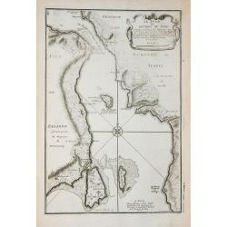
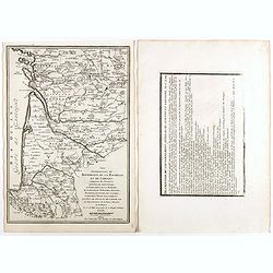
Le Sund ou Detroit du Sond.
Map of the Baltic sea, from "Atlas Curieux", printed in Paris.
Date: Paris, 1705
Selling price: ????
Please login to see price!
Sold in 2012
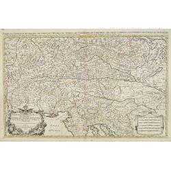
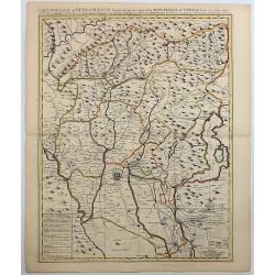
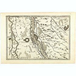
Partie du cercle d'Austriche, ou sont les duche's de Stirie, de Carinthie, de Carniole. . .
Very large map showing part of Northern Italy, Croatia, Austria and Slovenia. The map is fully and richly engraved. Large and extremely decorative cartouche with angels, ...
Date: Amsterdam, c.1705
Selling price: ????
Please login to see price!
Sold in 2010
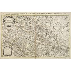
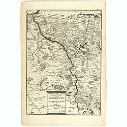
Etats de la Couronne de Boheme qui comprennent le Royaume de Boheme . . .
Extensive map centered on the rivers Elbe and Oder with Prague, including the eastern part of Germany and a part of Poland. The map is fully and richly engraved. Large an...
Date: Amsterdam, c.1705
Selling price: ????
Please login to see price!
Sold in 2023
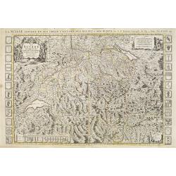
La Suisse divisée en ses treze cantons.
Very large map of Switzerland, ornated with a rococo title cartouche. 24 coats of arms along the left and right margin and another 9 coats of arms in lower left. Boundari...
Date: Amsterdam, c.1705
Selling price: ????
Please login to see price!
Sold in 2009
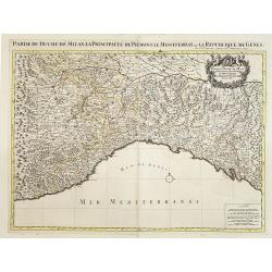
Partie du Duché de Milan la principauté de Piémont le Montferrat et la republique de Genes. . .
Very large map of the Duchy of Milan, including towns of Nice, Monaco, Turin, Milan, Genoa, Massa. With a sub title along upper margin. A first state, without with lines ...
Date: Amsterdam, c.1705
Selling price: ????
Please login to see price!
Sold in 2012
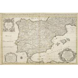
L'Espagne divisée en tous ses royaumes et Principautés. . .et sous la couronne de Portugal. . .
Very large map of Spain and Portugal, including the Balearic Islands Majorca, Minorca and Ibiza, ornated with a rococo title cartouche. A first state, without with lines ...
Date: Amsterdam, c.1705
Selling price: ????
Please login to see price!
Sold in 2011
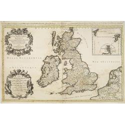
Les Isles Britanniques qui contiennents les- Royaumes, d' Angleterre, Escosse, et Irland.
Large scale map of England, Scotland and Ireland. To the left inset map of Shetland and Orkney Islands. A first state, without with lines of latitude and longitude. Extre...
Date: Amsterdam, c.1705
Selling price: ????
Please login to see price!
Sold in 2020
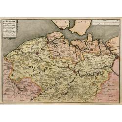
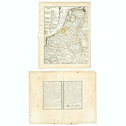
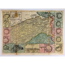
La Flandre espagnole, et la Flandre hollandoise ...
Detailed map of Flanders distinguishing the part in the past under Spanish domination from that under Dutch domination, from De Fer's Atlas Curieux.Showing Bruges, Gand, ...
Date: Paris, 1705
Selling price: ????
Please login to see price!
Sold in 2009
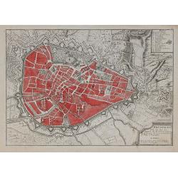
Bruselles ...
Map of Brussels from De Fer's Atlas Curieux.
Date: Paris, 1705
Selling price: ????
Please login to see price!
Sold in 2010
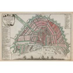
Amsterdam, Fameux port de mer.
Plan of Amsterdam, engraved by Van Loon, from De Fer's Atlas Curieux.
Date: Paris, 1705
Selling price: ????
Please login to see price!
Sold in 2010
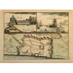
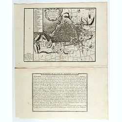
Lisbonne
This sheet combines a bird's-eye plan of the fortifications of Lisbon with two finely engraved views. At left is the "Palais Royal de Lisbonne" and at right &qu...
Date: Paris, 1705
Selling price: ????
Please login to see price!
Sold in 2010
Coste d Andalousie et D álgarve
Nice map of the street of Gibraltar with Gibraltar at left and the African coast at right with the cities Ceuta (Spain) and Tanger (Marocco).The map has an inset at left ...
Date: Paris, 1705
Selling price: ????
Please login to see price!
Sold in 2009
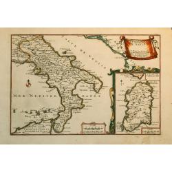
Le Royaume de Naples.
Nice map of the Southern part of Italy with also a part of Sicily and an inset of Sardinia.
Date: Paris, 1705
Selling price: ????
Please login to see price!
Sold in 2010
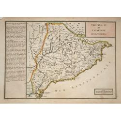
Principaute de Catalogne
A simply engraved map of the Spanish region of Catalonia depicting the Mediterranean coastline from the French border near Cadaques, southwest through Barcelona to the de...
Date: Paris, 1705
Selling price: ????
Please login to see price!
Sold in 2009
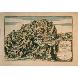
Maison et chambre .. Mont Serrat..Barcelone.
Nice view at the mountain Mont-Serrat close to Barcelona.
Date: Paris, 1705
Selling price: ????
Please login to see price!
Sold in 2009
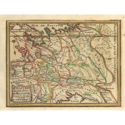
Estats du Grand Duc de Moscovie.
Small map of a part of Rusland.
Date: Paris, 1705
Selling price: ????
Please login to see price!
Sold in 2009
Carte de Brabant.
Guillaume del'Isle map of Brabant region of Belgium and the Netherlands.
Date: Paris, 1705
Selling price: ????
Please login to see price!
Sold in 2010
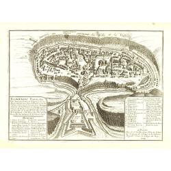
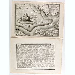
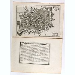
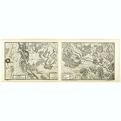
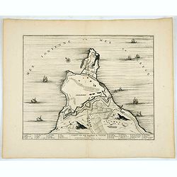
Kamieniec Podolski Ville forte des Estats de pologne et de la Haute Podotie. . .
Uncommon bird's eye view of the city of Kamianets-Podilskyi, located in western Ukraine. The print has in the lower left corner an explanatory panel with numbered (1-10) ...
Date: Paris, 1705
Selling price: ????
Please login to see price!
Sold in 2010
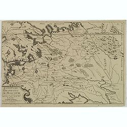
Estats du Grand Duc de Moscovie. . .
Lovely small map of Russia, Poland and reaching in the south to the Ukraine with Kiev. From De Fer's Atlas Curieux . . .
Date: Paris, c.1705
Selling price: ????
Please login to see price!
Sold in 2020
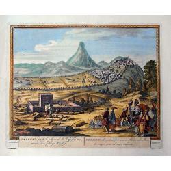
Derbent, een stadt gelegen aen de Kaspische Zee / Derbent, Atropatiae, sive Minoris Mediae urbs...
Rare view of Derbent the southern-most city in Russia, located near the Caspian Sea, supposedly the oldest city in Russia. Detailed and decorative view with numerous figu...
Date: Amsterdam, c1705
Selling price: ????
Please login to see price!
Sold in 2011
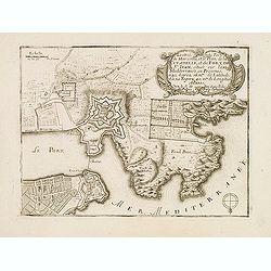
L'Entrée du PORT DE MARSEILLE et le Plan de la Citadelle et du Fort de St. Jean. . .
Early plan of Marseille. From his "Introduction à la fortification".
Date: Paris, 1705
Selling price: ????
Please login to see price!
Sold
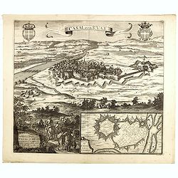
Casal dit de St. Vas. (Casale Monferrato)
A beautifully engraved and richly decorated bird's-eye view of Casale Monferrato in the Piedmont region.Joan Blaeu published during his life three town-books of Italy: Ci...
Date: Amsterdam, 1704/1705
Selling price: ????
Please login to see price!
Sold in 2014
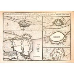
Les Quatre Villes Forestieres, Situees Sur le Rhein, Sent du Cercle de Souabe et a l'Empereur. Par N. de Fer.
Interesting set of four fortified towns on the Rhein River in Swabia, including Constance, Seckingen, Lauffenburg & Waldhust.Copper engraving is by Nicolas de Fer in ...
Date: Paris, 1705
Selling price: ????
Please login to see price!
Sold in 2016
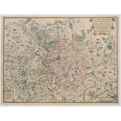
Le Pais Messin ses Dependances et Terre Adiacentes.
Fine hand-colored map centered on Metz in Germany. It was engraved by Nicholas De Fer in Paris in 1705. The Mozelle River flows down the center of the map.
Date: Paris, 1705
Selling price: ????
Please login to see price!
Sold in 2017
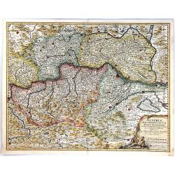
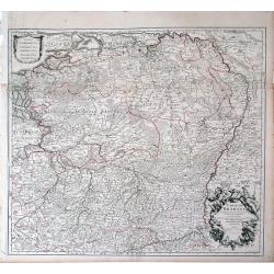
Austriae Archiducatus Pars Inferior
A finely engraved map of Lower Austria, along the Danube River, featuring numerous place names, cities, towns, villages, churches and topography.Vienna, Baden and many ot...
Date: Amsterdam, 1705
Selling price: ????
Please login to see price!
Sold in 2017
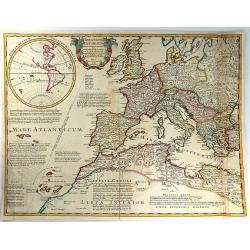
Theatrum Historicum ad annum Christi quadringentesimu in quo tu Imperii Romani tu Barbarorum...
A splendid map of the Roman Empire, showing its extent in 400 AD, covering most of North Africa, Southern Europe, and Britain as far as the Antonine Wall in Scotland. Ins...
Date: Paris, 1705
Selling price: ????
Please login to see price!
Sold in 2016
Les XVII Provinces Païs Bas Divisées.
An interesting small map of the Netherlands by Nicolas de Fer. From his rare "Petit et Nouveau Atlas". The first edition was published in 1697 and was republish...
Date: Paris, 1705
Selling price: ????
Please login to see price!
Sold in 2020
L'Italie divisée en ses principaux estats.
An interesting small map of Italy by Nicolas de Fer. From his rare "Petit et Nouveau Atlas". The first edition was published in 1697 and was republished in 1705...
Date: Paris, 1705
Selling price: ????
Please login to see price!
Sold in 2018
Novissima Russiae Tabula.
A fine and attractive map of Russia.Published by the Allard family in Amsterdam.
Date: Amsterdam, 1705
Selling price: ????
Please login to see price!
Sold in 2017

'T Stadhuys van Amsterdam.
Fine view of the City Hall in Amsterdam. A very busy scene with numerous people, horses, dogs, etc. Published in 'Algemene Wereldtbeschrijving', by Francois Halma, printe...
Date: Leeuwarden, 1705
Selling price: ????
Please login to see price!
Sold in 2016
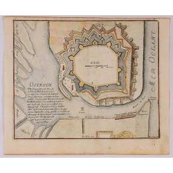
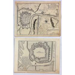
Ostende Ville forte et port de Mer du Comte de Flandre.
A fine view of the fort of Ostende in Belgium. It was published in Paris in 1695.It was engraved by Harmanus van Loon and is from “Atlas Les Forces de le Europe”.Nich...
Date: Paris, 1705
Selling price: ????
Please login to see price!
Sold in 2018
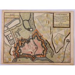
Oudenarde Ville Forte du Comte de Flandre.
A fine plan illustrating the important fortification of Oudenard in Belgium.Nicolas de Fer held the title of Geographer at Louis XIV's court. He was one of the most proli...
Date: Paris, 1705
Selling price: ????
Please login to see price!
Sold in 2019
Carte Nouvelle du Bergamasco Faisant Partie des Etats de la Venise.
This fine map is centered on Bergamo in the Lombardy region of northern Italy. Excellent detail of towns, roads, forts, and more. The map was created to depict the encamp...
Date: Amsterdam, 1705
Selling price: ????
Please login to see price!
Sold in 2017
Dendermonde Ville Forte des Pas Bas, du Comte de Flandres & Oudenarde Ville Forte du Comte de Flandre. . .
Dendermonde and Oudenarde, Two (2) Low Country copperplate engravings of fortification cities from Flanders in Belgium, by De Fer in Paris in 1705. From "Les Forces ...
Date: Paris, 1705
Selling price: ????
Please login to see price!
Sold in 2019
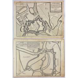
Ostende Ville Forte & Nieuport Port de Mer.
Ostende and Nieuport, Two (2) Low Country copperplate engravings of fortification cities from Flanders in Belgium. By De Fer in Paris in 1705. From "Les Forces de L'...
Date: Paris, 1705
Selling price: ????
Please login to see price!
Sold in 2019
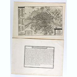
Le plan de la ville, cité, et université de Paris. Capitale du Royaume de France.
Engraved plan of Paris with a lettered key to the most important buildings in town, from Nicolas de Fer's "L'Atlas curieux ou le Monde réprésente dans des cartes. ...
Date: Paris, 1705
Selling price: ????
Please login to see price!
Sold
Gouvernement de Provence, generalité d'Aix.
Map of the Provence region, from Nicolas de Fer's "L'Atlas curieux ou le Monde réprésente dans des cartes. "The "Atlas Curieux" is a geographic ency...
Date: Paris, 1705
Selling price: ????
Please login to see price!
Sold
Isle, Rocher, Ville, château et Abbaye du Mont St Michel situé aux confins de Normandie et de Bretagne.
Engraved view of the Mont St Michel, with a numbered key (1-7) from Nicolas de Fer's "L'Atlas curieux ou le Monde réprésente dans des cartes. "The "Atlas...
Date: Paris, 1705
Selling price: ????
Please login to see price!
Sold
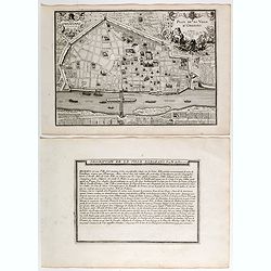
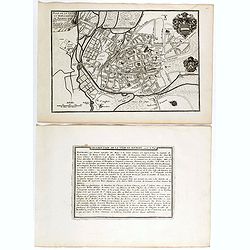
Plan de ville d'Orléans.
Engraved plan of the city of Orléans, from Nicolas de Fer's "L'Atlas curieux ou le Monde réprésente dans des cartes. "The "Atlas Curieux" is a geog...
Date: Paris, 1705
Selling price: ????
Please login to see price!
Sold
Lion.
Engraved plan of the city of Lyon, from Nicolas de Fer's "L'Atlas curieux ou le Monde réprésenté dans des cartes. "The "Atlas Curieux" is a geograp...
Date: Paris, 1705
Selling price: ????
Please login to see price!
Sold
Marseille, ville considerable de Provence fameux port sur la mer de Mérditerranée.
Engraved plan of the city of Marseille, with a numbered key (1-31), from Nicolas de Fer's "L'Atlas curieux ou le Monde réprésente dans des cartes. "The "...
Date: Paris, 1705
Selling price: ????
Please login to see price!
Sold

Pont du Gard / Amphiteatre de Nismes.
Engraved view of the Pont du Gard is near Nîmes, with a view of Nîmes famous amphitheater, from Nicolas de Fer's "L'Atlas curieux ou le Monde réprésente dans des...
Date: Paris, 1705
Selling price: ????
Please login to see price!
Sold
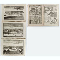
Le Château de Versailles et ses deux aisles, Veües du côté des jardins / Ecuries du Roy a Versailles, veües du côté Louvre / Le Palais de Clagny, près Versailles, Veüe du côté de Paris / La Menagrie de Versailles / Plan du Palais de Trianon / . . .
Six engraved views of different monuments and gardens of Versailles, from Nicolas de Fer's "L'Atlas curieux ou le Monde réprésente dans des cartes. ". The &qu...
Date: Paris, 1705
Selling price: ????
Please login to see price!
Sold in 2017
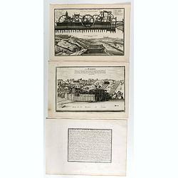
Coupe de la Machine de Marly / Veüe general de la Machine de Marly. (2 plates with text sheet)
Two engraved views of the Machine de Marly, also known as the Marly Machine, from Nicolas de Fer's "L'Atlas curieux ou le Monde réprésente dans des cartes. "....
Date: Paris, 1705
Selling price: ????
Please login to see price!
Sold in 2018
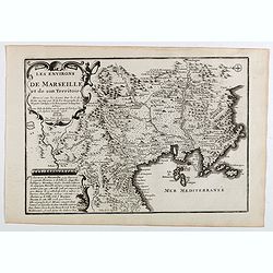
Les environs de Marseille et de son territoire . . .
Map centered on Marseille with nice detail of it surroundings, from Nicolas de Fer's "L'Atlas curieux ou le Monde réprésente dans des cartes. "The "Atlas...
Date: Paris, 1705
Selling price: ????
Please login to see price!
Sold
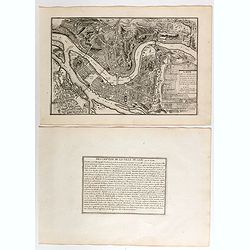
Plan de l'ancienne et nouvelle ville de Dijon.
Engraved plan of the town of Dijon, from Nicolas de Fer's "L'Atlas curieux ou le Monde réprésente dans des cartes. "The "Atlas Curieux" is a geograp...
Date: Paris, 1705
Selling price: ????
Please login to see price!
Sold
Les Environs de Namur, de Huy et de Charle-Roy and Les Environs de Dinant, de Philippeville et de Charlemont (2 Maps).
Two matching maps of southern Belgium by N. de Fer in 1705. Each features a decorative title cartouche. They centre on the Namur and Dinant regions of Belgium.Nicolas de ...
Date: Paris , 1705
Selling price: ????
Please login to see price!
Sold in 2018
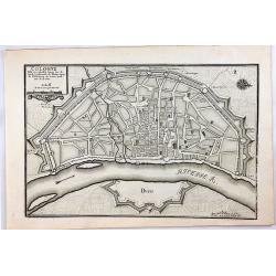
Cologne, Ville Considerable Situee.
A striking 1705 de Fer map of the walled city of Cologne, Germany. Oriented with north to the right, this map identifies the location of the city on the banks of the Rhin...
Date: Paris, 1705
Selling price: ????
Please login to see price!
Sold in 2020
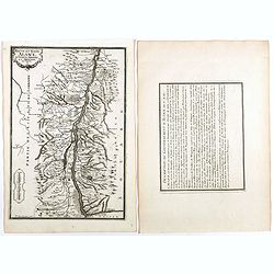
Les Duchez, de Lorraine, et de Bar . . .
Map of the Lorraine region, from Nicolas de Fer's "L'Atlas curieux ou le Monde réprésente dans des cartes. "The "Atlas Curieux" is a geographic ency...
Date: Paris, 1705
Selling price: ????
Please login to see price!
Sold in 2020
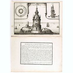
Tour de Cordouan.
View of Cordouan tower, which is nowadays a lighthouse, near the mouth of the Gironde estuary, from Nicolas de Fer's "L'Atlas curieux ou le Monde réprésente dans d...
Date: Paris, 1705
Selling price: ????
Please login to see price!
Sold in 2018
Plan de ville et des Fauxbourgs de Bourges . . .
Plan of Bourges town and its outskirts, from Nicolas de Fer's "L'Atlas curieux ou le Monde réprésente dans des cartes. "The "Atlas Curieux" is a geo...
Date: Paris, 1705
Selling price: ????
Please login to see price!
Sold
Les generalitez de Bordeaux, de La Rochelle, et de Limoges . . .
Map of the Gascony region, including Bordeaux, La Rochelle and Limoges, with several provinces such as Saintonge, Limousine ..., from Nicolas de Fer's "L'Atlas curie...
Date: Paris, 1705
Selling price: ????
Please login to see price!
Sold in 2021
Les deux Bourgognes Duché et Comté . . .
Map of the Bourgogne region, from Nicolas de Fer's "L'Atlas curieux ou le Monde réprésente dans des cartes. "The "Atlas Curieux" is a geographic enc...
Date: Paris, 1705
Selling price: ????
Please login to see price!
Sold in 2019
Haute et Basse Alsace, suntgout, Brisgou, et Ortenou.
Map of the Alsace region, from Nicolas de Fer's "L'Atlas curieux ou le Monde réprésente dans des cartes. "The "Atlas Curieux" is a geographic encycl...
Date: Paris, 1705
Selling price: ????
Please login to see price!
Sold in 2022
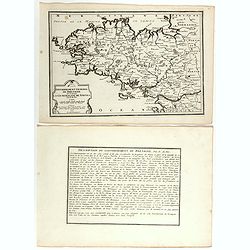
Gouvernement general de Bretagne ou se trouve la Generalité de Nantes.
Map of Bretagne, from Nicolas de Fer's "L'Atlas curieux ou le Monde réprésente dans des cartes. "The "Atlas Curieux" is a geographic encyclopedia of...
Date: Paris, 1705
Selling price: ????
Please login to see price!
Sold in 2020
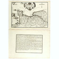
Gouvernement general de Normandie . . .
Map of Normandy region, from Nicolas de Fer's "L'Atlas curieux ou le Monde réprésente dans des cartes. "The "Atlas Curieux" is a geographic encyclop...
Date: Paris, 1705
Selling price: ????
Please login to see price!
Sold in 2018
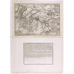
Environs de Paris.
Map centered on Paris, with its surroundings, from Nicolas de Fer's "L'Atlas curieux ou le Monde réprésente dans des cartes. "The "Atlas Curieux" is...
Date: Paris, 1705
Selling price: ????
Please login to see price!
Sold in 2020
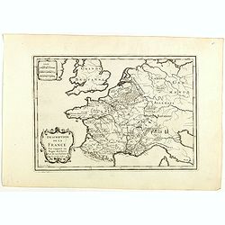
La France ses conquêtes, ses acquisitions et ses bornes . . .
General map of France, from Nicolas de Fer's "L'Atlas curieux ou le Monde réprésente dans des cartes. "The "Atlas Curieux" is a geographic encyclope...
Date: Paris, 1705
Selling price: ????
Please login to see price!
Sold in 2020
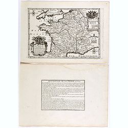
Description de la France par rapport au regne de Clovis et de ses enfants.
Map of France and part of Europe, with great Britain, from Nicolas de Fer's "L'Atlas curieux ou le Monde réprésente dans des cartes. "The "Atlas Curieux&...
Date: Paris, 1705
Selling price: ????
Please login to see price!
Sold in 2022
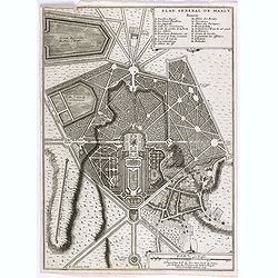
Plan general de Marly.
Plan of the city of Marly, from Nicolas de Fer's "L'Atlas curieux ou le Monde réprésente dans des cartes. "The "Atlas Curieux" is a geographic encyc...
Date: Paris, 1705
Selling price: ????
Please login to see price!
Sold
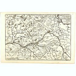
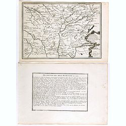
Generalitez de Tours, et d'Orleans et Grande Partie de celle de Bourges . . .
Map of Tours and Orleans regions, from Nicolas de Fer's "L'Atlas curieux ou le Monde réprésente dans des cartes. "The "Atlas Curieux" is a geographi...
Date: Paris, 1705
Selling price: ????
Please login to see price!
Sold in 2020
Les environs des deux Birsachs.
Map of old and new Brisachs, with Colmar and Fribourg from Nicolas de Fer's "L'Atlas curieux ou le Monde réprésente dans des cartes. "The "Atlas Curieux&...
Date: Paris, 1705
Selling price: ????
Please login to see price!
Sold in 2018
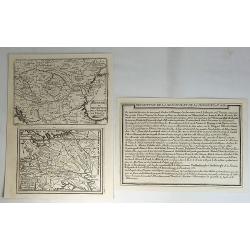
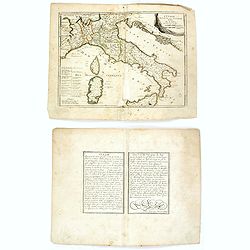
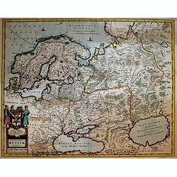
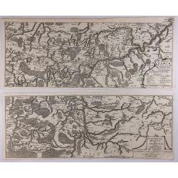
Hongrie ou Partie Septent de la Turquie. Estats du Grand Duc de Moscovie.
Two small maps by Nicolas de Fer, published in Paris in 1705. From his atlas ATLAS CURIEUX. Interestingly, it comes with description text.Nicolas de Fer (1646-1720) was ...
Date: Paris, 1705
Selling price: ????
Please login to see price!
Sold in 2018
Les environs des deux Brisachs et de Fribourg.
A two sheet map of Brisachs and Fribourg, from Nicolas de Fer's "L'Atlas curieux ou le Monde réprésente dans des cartes. "The "Atlas Curieux" is a g...
Date: Paris, 1705
Selling price: ????
Please login to see price!
Sold in 2018
![Sixieme plan de la ville de Paris, et ses accroissements depuis le régne de Charles VII. l'an 1422. jusqu'a la fin du régne de Henry III, l'an 1589 [...] par M.L.C.D.L.M.](/uploads/cache/41838-250x250.jpg)
Sixieme plan de la ville de Paris, et ses accroissements depuis le régne de Charles VII. l'an 1422. jusqu'a la fin du régne de Henry III, l'an 1589 [...] par M.L.C.D.L.M.
Sixth map of the city of Paris, and its additions, from the beginning of the reign of Charles VII in the year 1422 to the end of the reign of Henry III in the year 1589&q...
Date: Paris, 1705
Selling price: ????
Please login to see price!
Sold in 2020
![Sixieme plan de la ville de Paris, et ses accroissements depuis le régne de Charles VII. l'an 1422. jusqu'a la fin du régne de Henry III, l'an 1589 [...] par M.L.C.D.L.M.](/uploads/cache/42344-250x250.jpg)
Sixieme plan de la ville de Paris, et ses accroissements depuis le régne de Charles VII. l'an 1422. jusqu'a la fin du régne de Henry III, l'an 1589 [...] par M.L.C.D.L.M.
Sixth map of the city of Paris, and its additions, from the beginning of the reign of Charles VII in the year 1422 to the end of the reign of Henry III in the year 1589&q...
Date: Paris, 1705
Selling price: ????
Please login to see price!
Sold
Marseille ville considerable de Provence fameux port sur la mer de Mediterranée par N. De Fer.
Map centered on Marseille with nice detail of it surroundings, from Nicolas de Fer's "L'Atlas curieux ou le Monde réprésente dans des cartes. "The "Atlas...
Date: Paris, 1705
Selling price: ????
Please login to see price!
Sold in 2019
Le cours de la Sare aux environs de la quellese trouve diverses provinces qui composent la province de la Sare ou Lorraine Allemande.
Map of the Lorraine region with a part of west Germany, from Nicolas de Fer's "L'Atlas curieux ou le Monde réprésente dans des cartes. "The "Atlas Curieu...
Date: Paris, 1705
Selling price: ????
Please login to see price!
Sold in 2020
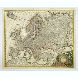
Europa Pars tenet Haec Mundi. . .
A nice, attractive map of the continent of Europe by G & L Valk of Amsterdam. The differing regions are colored in outline. Good map detail shown, and set off by a wo...
Date: Amsterdam, ca 1705
Selling price: ????
Please login to see price!
Sold in 2023
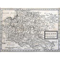
Poland. According to ye newest observations. . .
A small but detailed map of Poland, the Ukraine, Lithuania, Latvia, and parts of Russia. Extends from Vienna to Moscow, including Riga, Warsaw, Kaliningrad, Kiev, and man...
Date: London, ca 1705
Selling price: ????
Please login to see price!
Sold in 2019

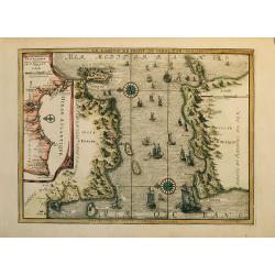
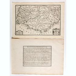
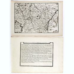
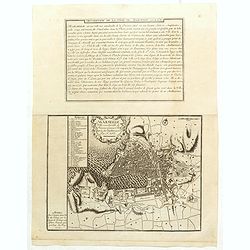
Grece Moderne ou Partie Meridionale de la Turquie en Europe.
A detailed map of the Southern Part of Greece and contiguous Islands. From De Fer's “Atlas Curieux”. Engraved by Van Loon. It comes with a page entitled “Descripti...
Date: Paris, 1705
Selling price: ????
Please login to see price!
Sold in 2021
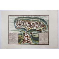
Kamieniec Podolski Ville forte des Estats de pologne et de la Haute Podolie. . .
An uncommon bird's eye view of the city of Kamianets-Podilskyi, located in western Ukraine. The print has in the lower left corner an explanatory panel with numbered (1-1...
Date: Paris, 1705
Selling price: ????
Please login to see price!
Sold in 2020
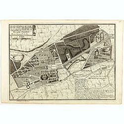
Plan général du Parc du Chau de l'Estang . . .
Plan of the park of l'Estang, from Nicolas de Fer's "L'Atlas curieux ou le Monde réprésente dans des cartes. "The "Atlas Curieux" is a geographic en...
Date: Paris, 1705
Selling price: ????
Please login to see price!
Sold in 2020
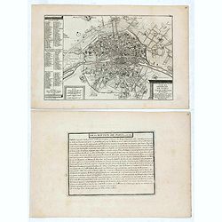
Le plan de la ville, cité, et université de Paris. Capitale du Royaume de France.
Engraved plan of Paris (22x33cm) with a lettered key to the most important buildings in town, from Nicolas de Fer's "L'Atlas curieux ou le Monde réprésente dans de...
Date: Paris, 1705
Selling price: ????
Please login to see price!
Sold in 2021
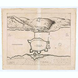
TRAW Ville de la Republique de Venise dans la Dalmatie.
Large view of the port city of Trogir (Trau) in Croatia with the fortress from a half bird's eye view. Joan Blaeu published during his life three town-books of Italy: Cit...
Date: Amsterdam, 1704- 1705
Selling price: ????
Please login to see price!
Sold in 2020
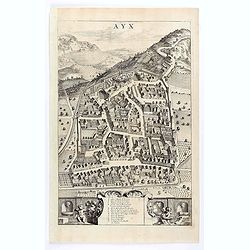
Ayx.
Detailed plan of Aix en Provence, in France. Joan Blaeu published during his life three town-books of Italy: Citta del Vaticano, Rome and Napoli. By the year 1672 a fire ...
Date: Amsterdam, 1704 / 1705
Selling price: ????
Please login to see price!
Sold in 2020
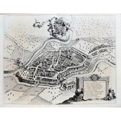
Rumiliacum vulgo Rumilly.
A striking large-scale bird's eye view of Rumilly in the French Alps (Haute-Savoie, Auvergne-Rhône-Alpes). Richly detailed buildings, gardens, bridges, and fields. And w...
Date: Amsterdam, ca 1705
Selling price: ????
Please login to see price!
Sold in 2020
CORFU Ville de la Republique de VENICE Dans la Dalmatie.
City plan of Corfu, the town and it's fortifications.Joan Blaeu published during his life three town-books of Italy: Citta del Vaticano, Rome and Napoli. By the year 1672...
Date: Amsterdam, 1704/1705
Selling price: ????
Please login to see price!
Sold in 2020
Nouvelle Carte Du Comte de Flandre.
An interesting map of Flanders first drawn by Daniel de la Feuille in 1706. A detailed map of the county of Flanders stretching from Dunkirk to the Schelde estuary. This ...
Date: Paris, 1706
Selling price: ????
Please login to see price!
Sold in 2018