Browse Listings in Europe
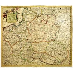
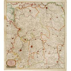
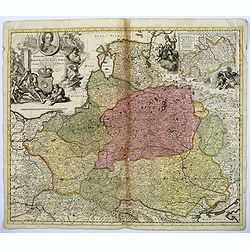
Regni Poloniae et Ducatus Lithuaniae Voliniae. . .
Rare issue of Justus Danckerts attractive map of Poland and Lithuania.Decorative title cartouche upper left hand corner.The map has strong original coloring, the titles f...
Date: Amsterdam, 1700
Selling price: ????
Please login to see price!
Sold in 2013
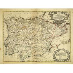
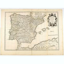
La Espana Dedicata all Ill Ed Ecc Sig. D. Carmine Niccolo Caracciolo. . .
Rare map of Spain and Portugal. Engraved by Andrea Magliar and published by Paolo Petrini. Based on a map of Nicholas De Fer.This is the first edition of the map, which i...
Date: Naples, 1700
Selling price: ????
Please login to see price!
Sold in 2013
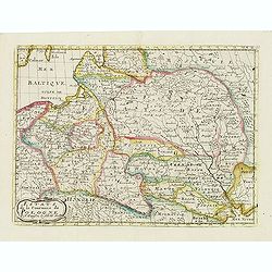
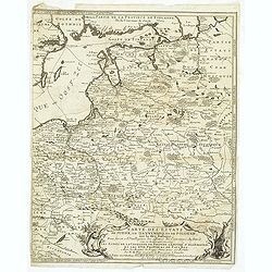
Les Etats de la couronne de Pologne.
Fine map of Poland, engraved by A. de Winter for "Description de tout L'Univers en plusieurs cartes, & en divers traitez de Geographie et d'Histoire. . .".
Date: Amsterdam, F.Halma, 1700
Selling price: ????
Please login to see price!
Sold in 2012
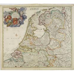
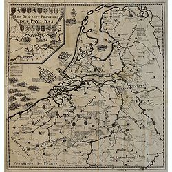
Belgium foederatum emendatius auctum. . .
Rare issue of Justus Danckert's attractive map of present-day The Netherlands.Decorative title cartouche upper left hand corner.
Date: Amsterdam, 1700
Selling price: ????
Please login to see price!
Sold in 2022

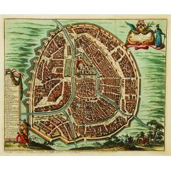
Ultraiectini dominii tabula.
Rare issue of Justus Danckert's attractive map of the province of Utrecht. Shows the land development in Utrecht, Holland, near the Zuyder Zee and it shows Utrecht, Amers...
Date: Amsterdam, 1700
Selling price: ????
Please login to see price!
Sold in 2012
Ducatus Brabantiae tabula continens sacri imperii. . .
Rare issue of Cornelis Danckert's attractive map of Brabant.Decorative title cartouche lower left hand corner.
Date: Amsterdam, 1700
Selling price: ????
Please login to see price!
Sold in 2023
Carte des Etats de Suede, de Dannemarq, et de Pologne sur le Mer Batlique. . .
Map covers Poland and Lithuania. Decorative title cartouche supported by a bear and a wild horse in lower right corner.In itself complete, but the right sheet, only, of a...
Date: Paris, 1700
Selling price: ????
Please login to see price!
Sold in 2012
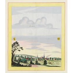
Sonnenburch
Very decorative and rare panoramic of Sonnenburg near Küstrin .The engraver and publisher of prints, Mrs. Anna Beek of the Hague, enlarged the print and mounted it on l...
Date: The Hague 1700
Selling price: ????
Please login to see price!
Sold in 2012
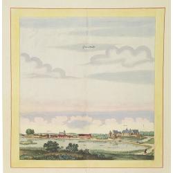
Liebenwalde.
Very decorative and rare panoramic of Liebenwalde a.d. Olse, Schlesien .The engraver and publisher of prints, Mrs. Anna Beek of the Hague, enlarged the print and mounted...
Date: The Hague, ca. 1700
Selling price: ????
Please login to see price!
Sold in 2012
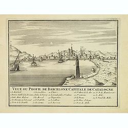
Veue ou Profil de Barcelone Capitale de Catalogne.
Panoramic view of Barcelona, with 23-point key.
Date: Paris, ca. 1700
Selling price: ????
Please login to see price!
Sold
Exactissima totius danubii fluvii tabula et minores. . .
Showing the western part of the course of the River Danube. Including the towns of Heidelberg, Venice, Vienna, Budapest, etc. Published by Theodor Danckerts.The part has ...
Date: Amsterdam, 1700
Selling price: ????
Please login to see price!
Sold in 2013
Tyrus.
This hand-colored, copper plate engraving shows a view of the port and city of Tyrus or Tyre, Lebanon. This scarce topographical print by de Bruyn is from: 'Voyage au Lev...
Date: Amsterdam, 1700
Selling price: ????
Please login to see price!
Sold in 2015
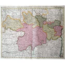
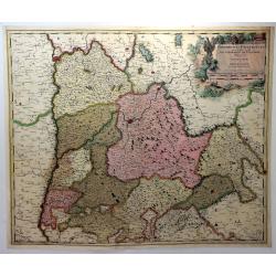
Ducatus Brunsuicensis in Eiusdem Tres Principatus Calenbergicum.
Fine map of the Duchy of Braunsweig. Featuring a large, splendid cartouche with nine coats of arms. The cities are shown as a detailed, miniature fortification. There are...
Date: Amsterdam, ca. 1700
Selling price: ????
Please login to see price!
Sold in 2017
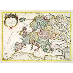
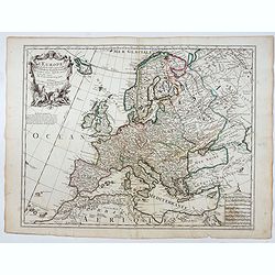
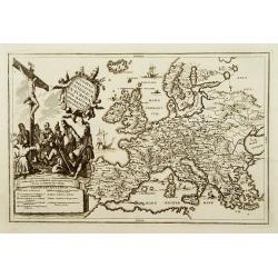
L\'Europe divisée suivant l\'estendue de ses principaux Estats...
Fine map of Europe, engraved by Cordier. With date "1695" in manuscript.
Date: Paris, c. 1700
Selling price: ????
Please login to see price!
Sold in 2013
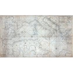
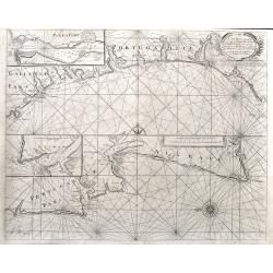
Paskaart van de Zee-kusten van Italie, Dalmatie, Sicilia, Grecia, Morea Malte en Candie. . .
A scarce, extensive nautical chart of the Mediterranean Sea, printed from two plates. We were not able to locate other specimens of this map. It depicts the coastlines of...
Date: Amsterdam, circa 1700
Selling price: ????
Please login to see price!
Sold in 2013
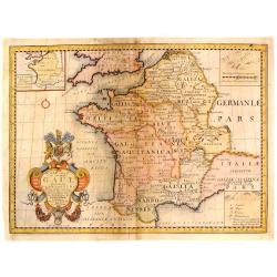
A New Map of Ancient Gaul or Gallia Transalpina.
A striking map of Ancient France during the time of Augustus Caesar. Includes a wonderful large title cartouche that includes fruit, ribbons and the Gloucester coat of ar...
Date: Oxford, 1700
Selling price: ????
Please login to see price!
Sold in 2017
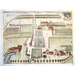
The East & West Prospect of Bushey Hall.
A very detailed plan of Bushey Hall with even the people quite detailed. It was published by Sir Henry Chauncy in "HISTORICAL ANTIQUITIES OF HERTFORDSHIRE" in 1...
Date: London, 1700
Selling price: ????
Please login to see price!
Sold in 2019
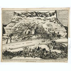
Plan exact des fortifications du Château de Choczim sur le Niester : avec le forts et retranchements de l'Armée des Turcs, défaite en 1673 par Jean Sobieski. . .
Depicting the victory of Jan Sobieski over the Turks at Khotyn in Ukraine in 1673. The victory allowed the Poles to revoke the unfavorable Peace of Buczacz and set the st...
Date: Leiden, P. van der AA, ca. 1700
Selling price: ????
Please login to see price!
Sold in 2015
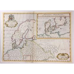
A New Map of Ancient Scandinavia together with as much more of y Northern Part of Ancient Europe as Anvers to Present Denmark & Moscovia
A map of Scandinavia, with an inset map of “Present Denmark”, from Edward Wells' "A New Sett Of Mapps Of Ancient And Present Geography ...". The engraver of...
Date: Oxford, 1700
Selling price: ????
Please login to see price!
Sold in 2018
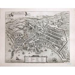
Neapolis
A magnificent, large view of Naples. Rare. Son of the cartographer and publisher Frederick de Wit (1610-1698), he bought plates of Jansson’s "Town Plans", iss...
Date: Amsterdam, ca 1700
Selling price: ????
Please login to see price!
Sold in 2017
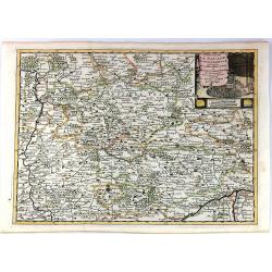
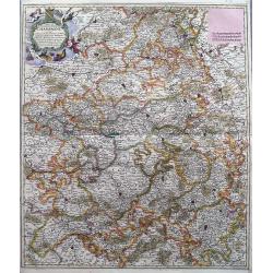
Cercle de la Souabe Septentrionale.
A detailed map by Pierre van der Aa of the German province of Soube, following the new observations of the “Academie Royale des Sciences”. It has a beautiful cartouch...
Date: Amsterdam, 1700
Selling price: ????
Please login to see price!
Sold in 2019
Praefectura Lugunensis Generalis...
A very detailed map of a part of South-Central France, centred on the former Auvergne region. Includes the cities of Périgueux, Limoges, Clermont-Ferrand, Montelimar, M�...
Date: Amsterdam, ca 1700
Selling price: ????
Please login to see price!
Sold in 2016
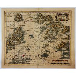
La Lorraine, qui Comprend les Duches de Lorraine et de Bar.
A handsome map of the Lorraine region of France. It includes the cities of Metz, Verdun and Nancy. The topography is detailed with trees, mountains and cities dotting th...
Date: Paris, 1700
Selling price: ????
Please login to see price!
Sold in 2016
![[Forteza di Catara]](/uploads/cache/36186-250x250.jpg)
[Forteza di Catara]
Uncommon print of the town of Kotor (citta di Cataro) in Montenegro.
Date: Italy, ca. 1700
Selling price: ????
Please login to see price!
Sold in 2016
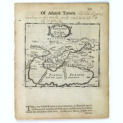
Tartaria in Europe.
This map appeared in Modern's rare 'Atlas Terestris', first published in 1687, depicting the regions surrounding the Black Sea.It features a pleasant scrolled title carto...
Date: London, 1700
Selling price: ????
Please login to see price!
Sold in 2016
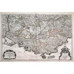
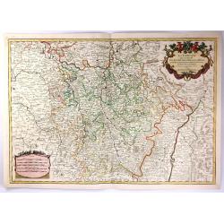
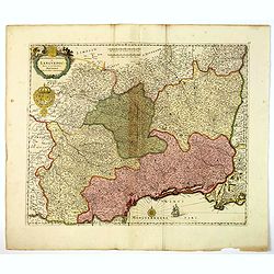
Le Comté et Gouvernement de Provence, divisée en ses vigueries...
Large scale map of Provence with immense detail after Sanson. Extends from Montélimar, Arles, and the Carmargue in the East, until Nice and Stroppo near Cuneo in the Wes...
Date: Amsterdam, ca. 1700
Selling price: ????
Please login to see price!
Sold in 2016
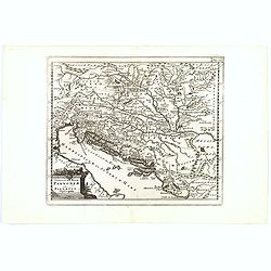
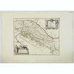
Veteris et Nova Pannoniae et Illyrici Descriptio.
A map of the north Balkans and northern Adriatic in ancient times. The map is based on the earlier Ortelius map of the same name. From Italy to Greece and inland to Morav...
Date: Amsterdam, ca. 1700
Selling price: ????
Please login to see price!
Sold in 2019
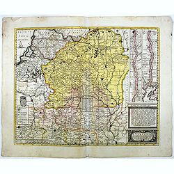
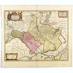
Magni ducatus Lithuaniae Caeterarumq Regionum illi adiacentium exacta descrip. . .
Highly detailed map of Lithuania and Belarus between Riga, Smolensk, Kiev, Cracow and Konigsberg, including two inset maps of the Dnieper River from Cherkasy to the Black...
Date: Amsterdam, 1700
Selling price: ????
Please login to see price!
Sold in 2016
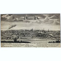
Moskow.
A rare view of Moscow.
Date: Germany, ca. 1700
Selling price: ????
Please login to see price!
Sold in 2017
Sivillia.
A lovely large, decorative town view on the Andalusian capital city of Seville, by F. de Witt. With imposing and important buildings identified, the river Guadalquivir is...
Date: Amsterdam, ca 1700
Selling price: ????
Please login to see price!
Sold in 2017
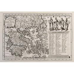
Archipelagi Graeciae Sive Maris Aegei Cum Praecipuis Suis Insulis...
A very detailed map of Greece and its islands. Includes also a portion of Turkey and South East Europe. With a table giving the ancient and modern names of all the island...
Date: Munich, ca.1700
Selling price: ????
Please login to see price!
Sold in 2017
Wetteravia die Wetterau.
A detailed map of the Wetterau region of Germany to the northeast of Frankfurt/Main, centred on Friedberg, reaching to Hofheim, Weilburg, Giessen, the Vogelsberg mountain...
Date: Amsterdam, ca. 1700
Selling price: ????
Please login to see price!
Sold in 2019
Plan du Fort de Rebus en Flandre.
A very fine map of the fortification of Rebus, in Flanders in northern Belgium. It features a drapery title cartouche and separate Information key.Nicolas de Fer (1646–...
Date: Paris, ca. 1700
Selling price: ????
Please login to see price!
Sold in 2017
Quartier de Louain???
Unique map of Brabant, Belgium. Louain or Louen or Leuven is the capital of the province of Flemish Brabant in Belgium. It is located about 25 kilometres east of Brussel...
Date: Brabant, ca. 1700
Selling price: ????
Please login to see price!
Sold in 2018
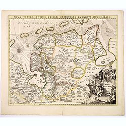
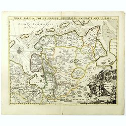
Nova Tabula Totius Frisiae Orientalis.
The map is a cooper engraved map of East Friesland by Carel Allard.
Date: Amsterdam, ca. 1700
Selling price: ????
Please login to see price!
Sold in 2017
Typus Generalis Ukrainae sive Palatinatuum Podoliae, Kioviensis et Braczlaviensis terras nova delineatione exhibens
Key map originally engraved by Johannes Janssonius in about 1656 and based on Guillaume La Vasseur de Beauplan's map of the region published in "Description d'Ukrain...
Date: Amsterdam, 1690 - 1700
Selling price: ????
Please login to see price!
Sold in 2020
![L'Europa dedicata All'Illustris ed Eccel. Mo Sig.re D.Giovanni Milano... [Part of a wall map]](/uploads/cache/41454-250x250.jpg)
L'Europa dedicata All'Illustris ed Eccel. Mo Sig.re D.Giovanni Milano... [Part of a wall map]
Upper left sheet of a 4 sheet wall map of Europe. Published by Paolo Petrini. Petrini's maps are considered great rarities and are highly collectable.The map is centered ...
Date: Naples, 1700
Selling price: ????
Please login to see price!
Sold in 2018
Delphinatus Praefectura Quae Gallis audit Gouvernement de Daufine.
A very detailed, antique map of the Dauphiné in the southeast of France by G. Valk. On the left the Rhône from Lyon, Vienne, Tournon-sur-Rhône, Valence to Montélimar....
Date: Amsterdam, ca. 1700
Selling price: ????
Please login to see price!
Sold in 2018
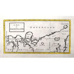
A Map of Groenland.
A scarce map of the southern coast of Greenland and the north Atlantic Ocean. The map is derived from Isaac la Peyrere's map of 1647. It locates Spitzberg, Iceland, the f...
Date: London, ca 1700
Selling price: ????
Please login to see price!
Sold in 2018
Frederico Augusto .. Polon. Lithuan. Borus. Pomer. Regi..
A decorative map and rare map of the Kingdom of Poland, which in the early eighteenth century included much of Ukraine, White Russia, and the Baltic States. There is an i...
Date: Amsterdam, 1700
Selling price: ????
Please login to see price!
Sold in 2018
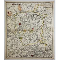
Comté et Gouvernement general de Champagne ou sont la Vraye Champagne, la Brie, le Remois, Retelois, Senonois, la Pertois, Bassigny. . .
A large and detailed map of the Champagne region, a part of Luxembourg in the north, and Auxerre in the south. Filled with place names and topographical information. With...
Date: Amsterdam, ca 1700
Selling price: ????
Please login to see price!
Sold in 2018
Nova Tabula Totius Frisiae Orientalis.
The map is a copper engraved map of East Friesland in Germany by Carel Allard. It shows the North Sea coastal line of Friesland with Emden and the islands Borkum, Nordern...
Date: Amsterdam, ca. 1700
Selling price: ????
Please login to see price!
Sold in 2018
![[Map of Scandinavia] La Scandinavie, et les Environs.](/uploads/cache/82018-250x250.jpg)
[Map of Scandinavia] La Scandinavie, et les Environs.
An attractive large-format map of Scandinavia. Embellished with two cartouches by Jaillot, H-J.
Date: Paris, ca 1700
Selling price: ????
Please login to see price!
Sold in 2019
La Moscovie Meridionale...
Detailed map centered on area north of Moscow, including part of Finland and Lapland. Charming title cartouche in lower right corner. This well executed engraving was pu...
Date: Leiden, 1700
Selling price: ????
Please login to see price!
Sold in 2018
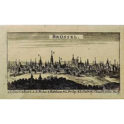
Brussel.
A miniature city view of Brussels, Belgium. It has a key to the main buildings along the bottom of the engraving. This print is not available now nor has been in the past...
Date: UNKNOWN, ca 1700
Selling price: ????
Please login to see price!
Sold in 2019
Carte de l'Europe Dressée sur les observations de Mrs de l'Academie Royale des Sciences . . .
An early and scarce state of "L’Europe. Chez l’Auteur sur le Quai de l’Horloge a la Couronne de Diamans, 1700".The finely engraved map shows Europe divide...
Date: Paris, 1700
Selling price: ????
Please login to see price!
Sold in 2025
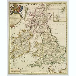
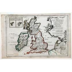
Les Isles Britanniques. . .
J.B. Nolin's map of the British Isles, based on the work of Coronelli. Map features an inset of the Orkney, Shetland and Faroe Islands. A splendid title cartouche adorns ...
Date: Paris, ca 1700
Selling price: ????
Please login to see price!
Sold in 2020
Flandriae Comitatus Pars Batava.
Fine detailed map of Flanders featuring the cities of Middleburg, Hulst, Dendermonde and Gent. It has very precise original coloring. By Visscher in Amsterdam.Nicolaes ...
Date: Amsterdam, c1700
Selling price: ????
Please login to see price!
Sold in 2020
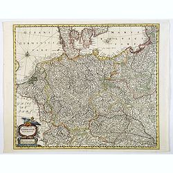
Nova Totius Germaniae Descriptio.
A highly detailed map of the Holy Roman Empire. It includes the modern day countries of Germany, Poland, Switzerland, Austria, The Netherlands, Belgium, the Czech Republi...
Date: Germany, ca 1700
Selling price: ????
Please login to see price!
Sold in 2020
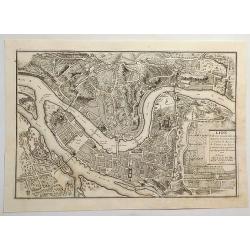
Lion, Ville Tres Considerable du Royaume.
A bird's-eye plan of Lion (Lyon) and vicinity that illustrates the strategic position of its fortifications on the Saône and the Rhône rivers. It provides an excellent ...
Date: Paris, 1700
Selling price: ????
Please login to see price!
Sold in 2023
Gouvernement General de Languedoc. Divise en ses Vint Deux Diocesez.
A lovely late seventeenth century map of the central south French region of Languedoc, part of which borders the Mediterranean Sea by Dutch publisher and cartographer, Fr...
Date: Amsterdam, ca 1700
Selling price: ????
Please login to see price!
Sold in 2019
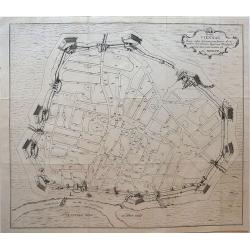
Hanc VIENNAE Quam vides Geometricam faciem Archimedem Siracusanum, Augustinus Hirsfogel a suo depictam radio imitatus est Anno. 1552.
Rare copper engraving of the circular plan of Vienna with its bastions, walls and wall towers, and gates. It shows the fortress Vienna after thoroughly modernizing its de...
Date: Vienna, around 1700
Selling price: ????
Please login to see price!
Sold in 2019
Veteris Pannonia utriusque nec non Illyrici descriptio Geographica . . .
A delightful map of the ancient Dalmatian coastline, that includes parts of modern day Austria, Hungary and Croatia, engraved by Joseph Thoal, and printed at the Seminary...
Date: Padua, ca 1700
Selling price: ????
Please login to see price!
Sold in 2023
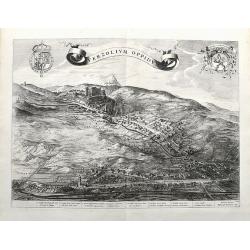
Verzolium Oppidum.
A large birds-eye view of the town of Verzuolo. The town lies between Cuneo and Torino. Superbly engraved with numerous houses, a monastery, and the general landscape. A ...
Date: Amsterdam, ca 1700
Selling price: ????
Please login to see price!
Sold in 2021
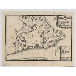
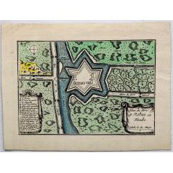
Plan du Chasteau de Dinant.
A plan of the castle of Dinant in Belgium, showing the fortifications. It features a ribbon decorative cartouche, and a detailed table of key places.
Date: Paris, ca 1700
Selling price: ????
Please login to see price!
Sold in 2020
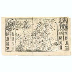
Les XVII Provincies des Pais Bas.
Map of the Netherlands, with coats of arms.
Date: Amsterdam, 1700
Selling price: ????
Please login to see price!
Sold in 2020
A Sea Chart of part of the Coasts of Gallisia and Portugall from Capo do Finisterre...
An unusual sea-chart of Portugal, two parts on one sheet. The top part is from Villa Nova until Peniche, the bottom part from Peniche until Lagos in the Algarve. Includes...
Date: London, ca 1700
Selling price: ????
Please login to see price!
Sold in 2021
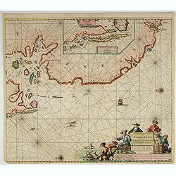
Pas-Kaert van de Cust van Noorwegen Beginnende van Der Neus tot aen Bommel Sond.
Very decorative sea chart of Norway by J. Van Keulen, shows VVest Agder and Rogaland, oriented to the East. Plate number 12 in lower right corner.Inset chart: Pascaertie ...
Date: Amsterdam, 1700
Selling price: ????
Please login to see price!
Sold in 2022
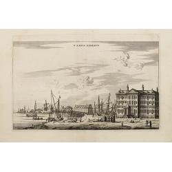
T' LANTS MAGESYN.
A decorative print of the 'T Landts Magazyn of the V.O.C. now-a-days the Maritime Museum.
Date: Amsterdam, 1700
Selling price: ????
Please login to see price!
Sold in 2023
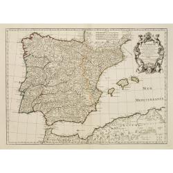
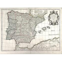
L'Espagne.
Beautiful map showing Spain and Portugal, the different Provinces ( Castille, Aragon, Andalousia..) and the North African coast. Decorative title cartouche.
Date: Paris, 1701
Selling price: ????
Please login to see price!
Sold
Les Isles Britanniques, ou sont les Royaumes d'Angleterre, d'Escosse et D'Ireland.
Map of the British Isles: England, Ireland and Scotland, each delineated through the use of different outline colors, from the atlas "Le Monde Dresse et Dedie Anosse...
Date: Paris, 1701
Selling price: ????
Please login to see price!
Sold in 2010
L'Espagne, dresse fur la Description qui en a ete faite par Rodrigo Mendez Sylva. . .
Finely detailed map Spain by Guillaume de L'Isle. Shows cities, villages, mountains and rivers. Also shown are the islands of Minorca, Mallorca and Ibiza and well as the ...
Date: Paris, 1701
Selling price: ????
Please login to see price!
Sold in 2010
Espagne et Portugal.
Small scale, detailed map of Portugal and Spain by French cartographer Nicholas de Fer. A decorative title cartouche is at the top right, and a small distance key is at t...
Date: Paris, 1701
Selling price: ????
Please login to see price!
Sold in 2010
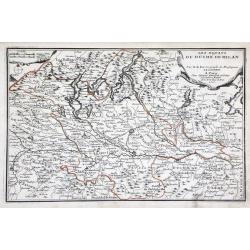
Les Estats du Duche de Milan. . .
Map of the duchy of Milan and surrounding regions. The territory of Milan, outlined in orange, was an independent state in northern Italy from 1395 to 1797, although an i...
Date: Paris, 1701
Selling price: ????
Please login to see price!
Sold in 2010
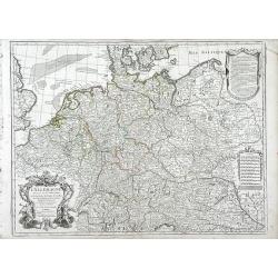
L'Allemagne Dressee sur les Observations de Tycho-Brahe de Kepler de Snellius sur celles de Messieurs de l'Academie Royale des Sciences
Finely detailed map of northwestern Europe including the countries of Northern France, Belgium, The Netherlands, Germany, Luxembourg, Switzerland, Northern Italy, Austria...
Date: Paris, 1701
Selling price: ????
Please login to see price!
Sold in 2010
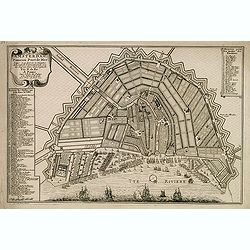
Amsterdam, fameux port de mer. . .
Fine town-plan of Amsterdam. Key at left identifies 83 important sites within the city. Key at upper right identifies the 26 "bastions" around the city walls, e...
Date: Paris, 1701
Selling price: ????
Please login to see price!
Sold in 2012
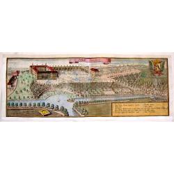
Schlos Bangberg.
Lovely, large copper engraved aerial view of Closter Barnvach and Schlos Bangberg. Features a ribbon title cartouche, a heraldy coat of arms with a fox and a block cartou...
Date: Munich, 1701
Selling price: ????
Please login to see price!
Sold in 2017
![Les Provinces Unies ou la Partie Septentrionale des Pays Bas . . . par le P. Coronelli . . . 1690 [together with] La partie Meridionale des Pays Bas connue sur le nom Flandre. . .](/uploads/cache/35670-250x250.jpg)
Les Provinces Unies ou la Partie Septentrionale des Pays Bas . . . par le P. Coronelli . . . 1690 [together with] La partie Meridionale des Pays Bas connue sur le nom Flandre. . .
Two attractive map of the northern and southern parts of the Low Countries. The northern part was produced by the Venetian cosmographer Vincenzo Coronelli when he was wor...
Date: Paris, 1701
Selling price: ????
Please login to see price!
Sold in 2015
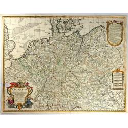
L'ALLEMAGNE, Dresse sur les Observations de Tycho Brahe, de Kepler, de Snellius....
This pleasant map shows Germany, as well as the Low Countries, Switzerland, Austria, parts of Poland and Hungary. Attractive ornamental cartouche with trumpet players, fl...
Date: Paris, 1701
Selling price: ????
Please login to see price!
Sold in 2016
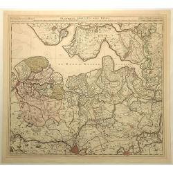
Provinces Unies des Pays Bas
A uncommon map of the XVII Provinces.
Date: Amsterdam 1701
Selling price: ????
Please login to see price!
Sold in 2018
![Sea of Azov The Eastern Part of the Sea [usually known as] Palus Maeotis and now Called the Sea of Azov...(Vostochnaja chast' morja palus meotis i nyne nazyvaetsja azovskoe more...)](/uploads/cache/43912-250x250.jpg)
Sea of Azov The Eastern Part of the Sea [usually known as] Palus Maeotis and now Called the Sea of Azov...(Vostochnaja chast' morja palus meotis i nyne nazyvaetsja azovskoe more...)
Very rare and important chart of the eastern part of the Sea of Azov, the Kerch Strait and parts of the Black Sea. This important chart was compiled from measurements an...
Date: Moscow, Kremlin Armoury, 1701
Selling price: ????
Please login to see price!
Sold in 2019
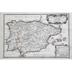
L'Espagne . . .
Detailed map showing Spain and Portugal, the different Provinces ( Castille, Aragon, Andalousia..) and the North African coast. Decorative title cartouche.The rare Amster...
Date: Amsterdam, ca. 1701
Selling price: ????
Please login to see price!
Sold in 2022
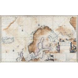
Nieuwe Paskaart Inhoudende t'Noorder deel van Europa sijnde seer Dienstigh voor de Groenlandse en Moscovise Scheepvaard.
A very large, exceptionally rare, early navigation chart of Scandinavia by van Keulen, with highly decorative hunting scenes. The chart is based on Mercator projection. G...
Date: Amsterdam, 1701
Selling price: ????
Please login to see price!
Sold in 2022
![[Lot of 5 maps of the Iberian peninsula / Belearics]](/uploads/cache/18379-(2)-250x250.jpg)
[Lot of 5 maps of the Iberian peninsula / Belearics]
Guillaume de l' Isle (1675-1724), Royal Geographer, was the most influential cartographer of the first quarter of the 18th century. ' Atlas de Géographie' (1700-12), pos...
Date: 1701
Selling price: ????
Please login to see price!
Sold in 2022
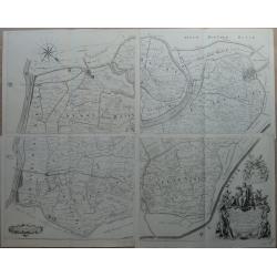
Kaart van de Ring van Putten, bestaande uit vier delen Caerte gemaeckt op ordre vande bovengenoemde heeren opperdijckgraeff en hoog heemraden des Ringhs van Putten
Wall map consisting of four separate maps, each measuring 50 x 63 cm. The Ring van Putten concerns the region south of Rotterdam, with cities such as Spijkenisse, Geervli...
Date: 1701
Selling price: ????
Please login to see price!
Sold in 2022
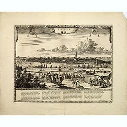
Moscou, Capitale de la Moscovie..
Detailed bird's-eye view of the town of Moscow.
Date: Leiden, 1702
Selling price: ????
Please login to see price!
Sold in 2008

Cologne, ville considérable...
Handsome city plan of Cologne, situated on the River Rhine. Shows fortifications, streets, churches, etc. Decorated with a title cartouche and compass rose.
Date: Paris c.1702
Selling price: ????
Please login to see price!
Sold
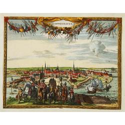
Coppenhaven.
Attractive view of the city and the port of Copenhagen. Very decorative title cartouche on the upper part.
Date: Amsterdam 1702
Selling price: ????
Please login to see price!
Sold
Status religionis catholicae in Europa per mappam geographicam proposito.
A map from the series of maps by the Jesuit mathematician. A general map of Europe, produced by Scherer to show the spread of Catholicism in the continent. There are 2 sh...
Date: Munich c.1702
Selling price: ????
Please login to see price!
Sold
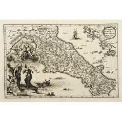
Dominium temporale pontificis Romani in Italia.
A map from the series of maps by the Jesuit mathematician. A general map of central Italy, produced by Scherer to show the spread of Catholicism in the country. Heinrich ...
Date: Munich c.1702
Selling price: ????
Please login to see price!
Sold