Browse Listings in Europe
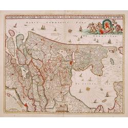
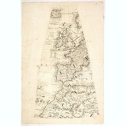
Comitatus Hollandiae tabula pluribus..
West to the top. Lower left inset of the Wadden Islands, Texel, Vlieland, Terschelling and part of Ameland.
Date: Amsterdam 1698
Selling price: ????
Please login to see price!
Sold
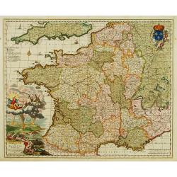
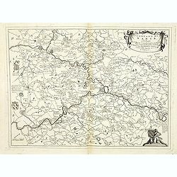
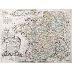
Galliae seu Franciae Tabula.
The map is decorated with a beautiful cartouche relating to Neptune and the four elements and with the French coat of arms.
Date: Amsterdam, ca. 1698
Selling price: ????
Please login to see price!
Sold
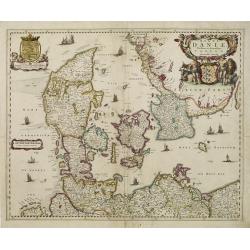
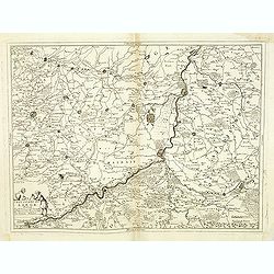
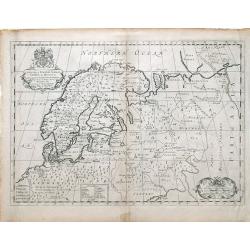
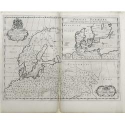
Regni Daniae Novissima et Accuratissima Tabula.
An uncommon issue of the magnificent map of all of Denmark and the tip of Sweden. The land is fully engraved with mountains, forests and cities, while the sea is filled w...
Date: Amsterdam 1698
Selling price: ????
Please login to see price!
Sold
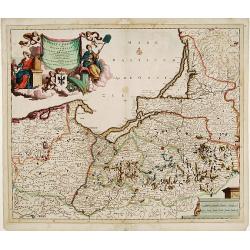
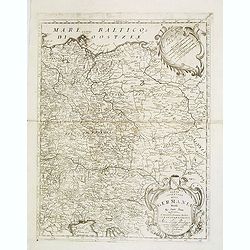
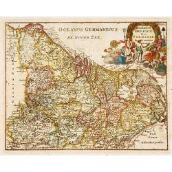
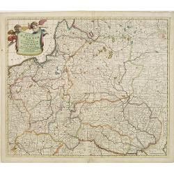
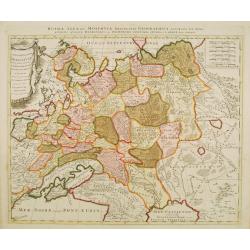
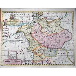
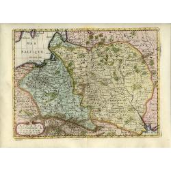
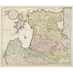
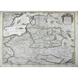
Ducatus Prussiae tam Polono Regiae..
Rare issue of Justus Danckert's attractive map of northern part of Poland.Decorative title cartouche upper left hand corner.
Date: Amsterdam, 1698
Selling price: ????
Please login to see price!
Sold in 2010
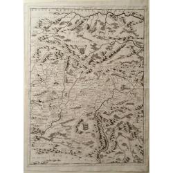
Map of Romania, Including Transylvania
Map of Romania including Transylvania by Vincenzo Coronelli. Overall a wonderfully detailed composition which features the location of Major Mountain ranges rivers and ma...
Date: Venice, 1698
Selling price: ????
Please login to see price!
Sold in 2010
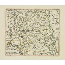
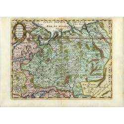
La Russie Blanche ou MOSCOVIE.
Scarce miniature map centered on Moscow, from the rare atlas " El atlas abreviado, o compendiosa geografia del mundo antiguo, y nuevo. . ." by Francesco de Affe...
Date: Antwerp, Jan Duren, 1698
Selling price: ????
Please login to see price!
Sold in 2012
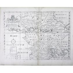
Regno di Negroponte Descritto e Dedicato al Reverendismo. P. Maestro Felice Rotondi . . .
A beautiful and flamboyantly engraved large-scale view of Chalkida (Halkida) with in the top right corner an inset map of the island of Evia. With a wide decorative flora...
Date: Venice, 1698
Selling price: ????
Please login to see price!
Sold in 2012
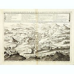
Antica e Moderna Citta d'Atene dedicata dal P. Coronelli. . .
A beautiful and flamboyantly engraved large-scale plan of Ancient Athenes. The map is the product of the late 17th century Venetian cartographer, Vincenzo Coronelli. A de...
Date: Venice, 1698
Selling price: ????
Please login to see price!
Sold in 2012
Vesvocato di Liege. . .
A beautiful and flamboyantly engraved large-scale map of the region Liege, Maastricht, Hasselt in Belgium and the Nethermlands.In the lower left the title cartouche with ...
Date: Venice, 1698
Selling price: ????
Please login to see price!
Sold in 2019
Contado di Namur . . .
A beautiful and flamboyantly engraved large-scale map of Namur region in central Belgium. Includes several coats of arms.On verso a map of the Malay Peninsula as far sout...
Date: Venice, 1698
Selling price: ????
Please login to see price!
Sold in 2019
![[No title] Nine views of Italian buildings, churches in Ravenna.](/uploads/cache/32808-250x250.jpg)
[No title] Nine views of Italian buildings, churches in Ravenna.
A page with nine views of buildings, churches and monuments in Ravenna.On verso a map of the Malay Peninsular as far south as Singapore. (215x275mm) With three small brow...
Date: Venice, 1698
Selling price: ????
Please login to see price!
Sold in 2012
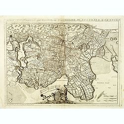
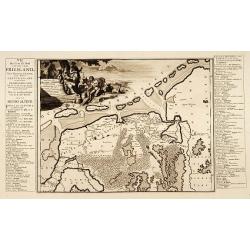
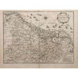
Parte septtentrionale dell' Hollanda, vulgo Westuriesland en Tnoorder Quartier. . .
A beautifully engraved map of northern Netherlands or "West Friesland", including the towns of Amsterdam, Hoorn, Haerlem, t'Huys, Edam, etc. The region is fille...
Date: Venice, 1698
Selling price: ????
Please login to see price!
Sold
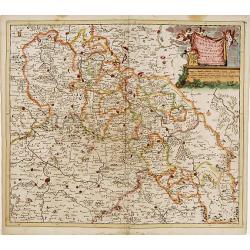
Parte orientale della Germania. . .
A beautiful and flamboyantly engraved large-scale map of Poland, Eastern part of Germany and Austria. On verso a map of the Malay Peninsular as far south as Singapore. (2...
Date: Venice, 1698
Selling price: ????
Please login to see price!
Sold in 2012
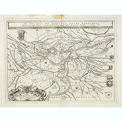
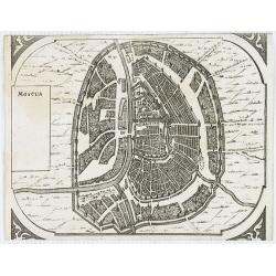
Il Ducato di mantova nella Lombardia. . .
A beautiful and flamboyantly engraved large-scale map of Mantova region in Lombardia. On verso letter press with a view of Lake Garda "Isole del Lago di Garda" ...
Date: Venice, 1698
Selling price: ????
Please login to see price!
Sold in 2017
![Parallelo Geografico dell'Antico col Moderno Arcipelago ... [in set with] Parte Meridionale dell' Arcipelago. . .](/uploads/cache/32827-250x250.jpg)
Parallelo Geografico dell'Antico col Moderno Arcipelago ... [in set with] Parte Meridionale dell' Arcipelago. . .
A beautiful and flamboyantly engraved large-scale map showing the Marmara Sea or Sea of Marmora (ancient Propontis), inland sea, north-western Turkey, connected to the Bl...
Date: Venice, 1698
Selling price: ????
Please login to see price!
Sold in 2012
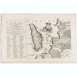
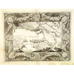
Isola d'Oleron.
A beautiful map showing the isle of Oleron, located in the Bay of Biscay off the coast of France, from Vincenzo Coronelli's Corso Geografico Universale.A numbered key of ...
Date: Venice, 1698
Selling price: ????
Please login to see price!
Sold in 2012
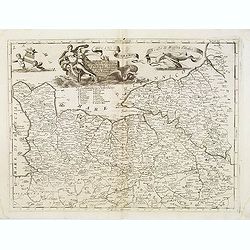
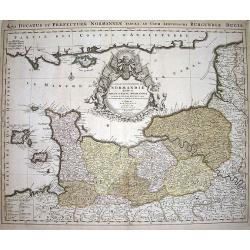
Ducato di Normandi.
A beautiful and flamboyantly engraved large-scale map of Normandy, with a fine title cartouche featuring Leda in her carriage drawn by swans.On verso are plans of Le Havr...
Date: Venice, 1698
Selling price: ????
Please login to see price!
Sold
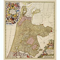
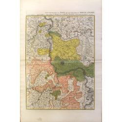
Kennemaria et Westfrisia vulgo et vernacule Noord Holland.
A most decorative map, in bright full original colors, of the northern part of Holland. At that time practically all polders -with the exception of the IJ-polder- had alr...
Date: Amsterdam, 1698
Selling price: ????
Please login to see price!
Sold in 2012
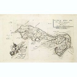
Isola del Re Nel Mare di Guascogna. . .
A beautiful map showing Ile de Ré in Bretagne, located in the Bay of Biscay off the coast of France, from Vincenzo Coronelli's Corso Geografico Universale.Italian text o...
Date: Venice, 1698
Selling price: ????
Please login to see price!
Sold
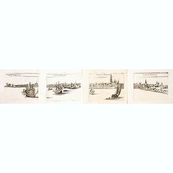
Veduta di Rotterdam (4 sheet view of Rotterdam)
A beautiful and flamboyantly engraved detailed panoramic view of Rotterdam. The Laurens Church, still with his wooden lantern [removed ca. 1650] upon the bell tower. A de...
Date: Venice, ca. 1698
Selling price: ????
Please login to see price!
Sold in 2014
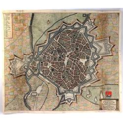
Ichnographia Munitissima Urbis Valentiae Quae Gallice Pronunciatur Valenciennes Belgice.
A detailed large bird's eye city view of Valenciennes, in France, by De Wit. The plan shows individual buildings, streets and trees. The map is adorned by a title cartouc...
Date: Amsterdam, 1698
Selling price: ????
Please login to see price!
Sold in 2016
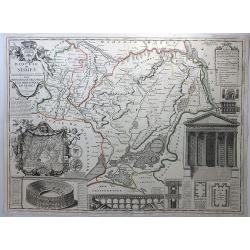
Diocese de Nismes.
A very busy map in the style of J.B. Nolan featuring Nismes in Belgium, and vignettes of its high points including the Amphitheatre, La Maison Quarrie, Temple de Dianne, ...
Date: Paris, 1698
Selling price: ????
Please login to see price!
Sold in 2018

Ducatus Prussiae tam Polono Regiae. . .
This is a rare issue of Frederick de Wit's attractive map of the northern part of Poland, Prussia and the Baltic regions.Very decorative title cartouche, including three ...
Date: Amsterdam, 1698
Selling price: ????
Please login to see price!
Sold in 2024
Le Royaume de France...
Well engraved 17th century copper engraved map of France. The large title cartouche is surrounded by a plan of Paris and 10 other cities in France.
Date: Paris, 1698
Selling price: ????
Please login to see price!
Sold in 2019
![Scotia parte settentrionale. . . [together with] Scotia parte meridionale . . .](/uploads/cache/45627-250x250.jpg)
Scotia parte settentrionale. . . [together with] Scotia parte meridionale . . .
A large two-sheet map of Scotland. The Northern map features a list of provinces and their capitals at the upper left and a title cartouche on the right side. The Souther...
Date: Venice, 1698
Selling price: ????
Please login to see price!
Sold in 2020
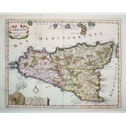
La Sicile Divisee en ses trois Valles
A fabulous small map of Sicily showing the island's political divisions, with considerable detail of topography, cities, towns and villages. The work also includes the Ae...
Date: Paris, 1699
Selling price: ????
Please login to see price!
Sold
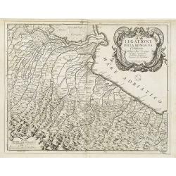
Legatione della Romagna . . .
A uncommon, late 17th century map of part of the Romagna region, based on the reports of Giacomo Cantelli da Vignola and published in Rome, by Domenico de Rossi's in his ...
Date: Rome, ca. 1699
Selling price: ????
Please login to see price!
Sold in 2009
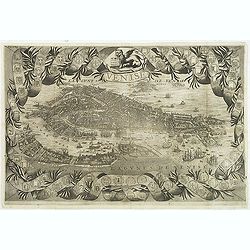
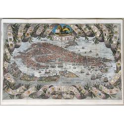
Venise.
A rare and decorative bird's eye view of Venice, copied after Coronelli's plan of 1693. Included in "Voyages De Mr. Du Mont En France, En Italie, En Allemagne, à Ma...
Date: Paris, Etienne & François Foulque, c.1699
Selling price: ????
Please login to see price!
Sold in 2011
Globe gore with West Europe and Morocco.
Half-gore from his 110 centimeters in diameter globe of 1688 with part of West Europe, including England, Iceland, Netherlands, Belgium, France, Spain and Portugal. Moroc...
Date: Venice, 1696/1699
Selling price: ????
Please login to see price!
Sold in 2015
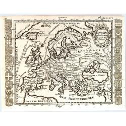
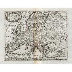
L'Europe Selon les Auth les Plus Modernes.
A rare map of Europe by Matthieu Ogier, published in Lyon in 1699. The map spans from Portugal to the eastern edge of the Mediterranean Sea and from Northern Africa to Gr...
Date: Lyon, 1699
Selling price: ????
Please login to see price!
Sold in 2016
Venetien.
A rare unrecorded variant of Coronelli's spectacular bird's eye view of Venice. Hand colored, very possibly old coloring. A spectacular view of Venice, with a highly deco...
Date: Paris, ca. 1699
Selling price: ????
Please login to see price!
Sold in 2020
Hodiernae Belgicae sive Germaniae..
Decorative miniature map of the Low Countries. West to the top.
Date: Amsterdam 1700
Selling price: ????
Please login to see price!
Sold
Frisiae Libera.
Unusual map of ancient Holland Germany and Belgium. The "Zuthera Zea" is still enclosed and a great portion of the country is covered with swamps and forests.Se...
Date: Amsterdam 1700
Selling price: ????
Please login to see price!
Sold
Regni Poloniae et Ducatus Lithuaniae Voliniae..
Rare issue of Justus Danckerts attractive map of Poland and Lithuania.Decorative title cartouche upper left hand corner.SEE a large description of the Danckerts family on...
Date: Amsterdam 1700
Selling price: ????
Please login to see price!
Sold
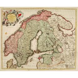
La Scandie.. Suede, Danemarc & Norvegue.
Fine map including Sweden, Norway, Denmark and Finland. Decorative title cartouche with dedication to Charles XII. Prepared by Nicolaas Visscher, a uncommon re-issue by P...
Date: Amsterdam 1700
Selling price: ????
Please login to see price!
Sold
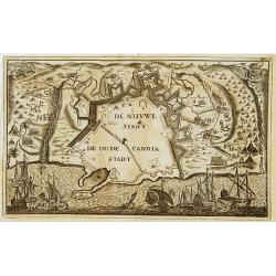
De Nieuwe Stadt / De Oude Stadt Candia.
Rare plan of the town of Candia. With extensive shipping on foreground and Turkish troops sieging the town.The Siege of Candia (Heraklion, Crete) (1648-1669) was possibly...
Date: Netherlands c.1700
Selling price: ????
Please login to see price!
Sold
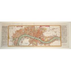
LONDEN WESTMUNSTER U SOUDWARK
A very finely engraved view of London as seen at the start of the 18th century. The work's title is presented in two ribbons at the top portion of the engraving. Two comp...
Date: Germany, c. 1700
Selling price: ????
Please login to see price!
Sold
La Russie Blanche ou Muscovie
European Russia, including Ukraine.
Date: Amsterdam 1700
Selling price: ????
Please login to see price!
Sold
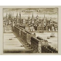
Die Brücke zu London.
Decorative view of London bridge.
Date: Nuremberg 1700
Selling price: ????
Please login to see price!
Sold
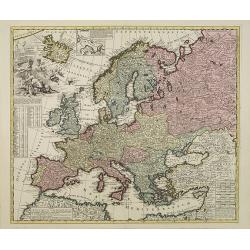
Europae in Tabula Geographica Delineatio. . .
Uncommon map of Europe with fine title cartouche and key to longitude and latitude of the most import cities.
Date: Amsterdam, 1700
Selling price: ????
Please login to see price!
Sold in 2013
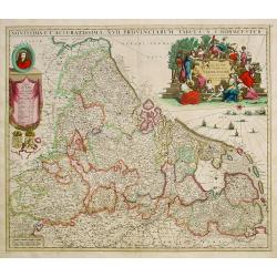
Novissima et accuratissima XVII Provinciarum tabula A. J.Bormeester.
Rare issue of Justus Danckert's attractive map of the Low Countries.Decorative title cartouche upper right hand corner.
Date: Amsterdam 1700
Selling price: ????
Please login to see price!
Sold
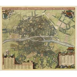
Lutetiae Parisiorum Universae Galliae Metropolis Novissima & Accuratissima Delineatio per F. de Wit cum Privilegio.
Bird-eye view of Paris, with key to the different locations. De Wit used the copper plate of Joannes de Ram from 1690. The plan was made after Jouvin de Rochefort and sho...
Date: Amsterdam, c. 1700
Selling price: ????
Please login to see price!
Sold
A New Map of Antient Germany, Rhaetia, Vindelicia, and Noricum...
Interesting map of central Europe during ancient times. Extending from Denmark to northern Italy. Includes Germany, the Netherlands, Poland, Austria,... From "A N...
Date: Oxford, c1700
Selling price: ????
Please login to see price!
Sold in 2013
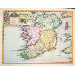
L''irelande suivant les nouvelles observations
A beautifully rendered and sought after map of Ireland. The cartouche depicts a pastoral scene with horsemen, hunters and various domesticated and wild animals. A very de...
Date: Leiden, ca. 1700
Selling price: ????
Please login to see price!
Sold in 2008
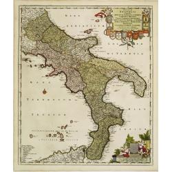
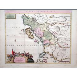
Regnum Neapolis..
Uncommon re-issue of this fine map of the southern part of Italy. In top putti holding the 12 coats of arms. Lower right scale and putti holding coat of arms of the town ...
Date: Amsterdam, 1700
Selling price: ????
Please login to see price!
Sold in 2008
![[2 charts] Accuratissima Occidentalioris Districtus Maris Mediterranei.. / Accuratissima Orientalis Districtus Maris Mediterranei..](/uploads/cache/09561-250x250.jpg)
[2 charts] Accuratissima Occidentalioris Districtus Maris Mediterranei.. / Accuratissima Orientalis Districtus Maris Mediterranei..
Rare issue of Justus Danckert's attractive 2-sheet map of Mediterranean sea. Decorative title cartouche lower left hand corner.
Date: Amsterdam, 1700
Selling price: ????
Please login to see price!
Sold
La Russie Blanche ou Muscovie
Uncommon map of European Russia, including Ukraine.
Date: Amsterdam, 1700
Selling price: ????
Please login to see price!
Sold
![[ Lago di Sabaudia / Baia d'Argento ] Manuscript map on paper.](/uploads/cache/30281-250x250.jpg)
[ Lago di Sabaudia / Baia d'Argento ] Manuscript map on paper.
A large and decorative manuscript map on paper, oriented west to the top. In the center "Lago di Santa Maria", which is presently called "Baia D'Argento&qu...
Date: Italy, c.1700
Selling price: ????
Please login to see price!
Sold in 2011
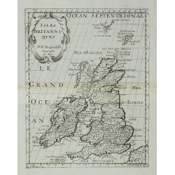
Isles Britanniques.
A map of the British Isles from Description de tous l'Univers published by François Halma.
Date: Amsterdam, 1700
Selling price: ????
Please login to see price!
Sold in 2011
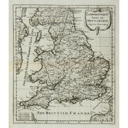
La Britannique dans sa Heptarchie ...
A map of the England from Description de tous l'Univers published by François Halma.
Date: Amsterdam, 1700
Selling price: ????
Please login to see price!
Sold in 2011
Etats de la Couronne de Pologne.
Detailed map covering the region of present-day Poland, Lithuania, Belarus and Ukraine. Engraved by Anthony d'Winter.
Date: Amsterdam, 1700
Selling price: ????
Please login to see price!
Sold in 2008
Russie Blanche ou Moscovie
Attractive copper engraved map of European Russia showing its political divisions, major topographical features, cities and towns. It is embellished with a strapwork titl...
Date: Amsterdam, 1700
Selling price: ????
Please login to see price!
Sold in 2008
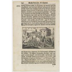
Barcellona.
A page of printed text in German with an engraving of an attack on the city of Barcelona.
Date: Germany, ca.1700
Selling price: ????
Please login to see price!
Sold in 2009
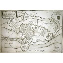
COPENHAGUE Ville Capitale du Royaume de Dannemarq...
Very detailed plan of Copenhagen with a letter key (A-F) identifying important buildings. Shows the city and surrounding area with great detail such as the fortifications...
Date: Paris, 1700
Selling price: ????
Please login to see price!
Sold in 2010
Le Duché et Gouvernement du Normandie diviseé...
Large scale map of Northern France, with excellent detail of La Manche. Latin title "Nova ducatus et praefecturae normanniae tabula, ad usum serenissimi burgundi...
Date: Amsterdam, ca1700
Selling price: ????
Please login to see price!
Sold in 2009
Accuratissima Ducatus Silesiae eique Regnum Bohemiae..
Rare issue of Theodorus Danckert's attractive map of part of Poland, centered on Breslau.Decorative title cartouche upper right hand corner.
Date: Amsterdam, 1700
Selling price: ????
Please login to see price!
Sold in 2013
Moscua.
Very rare bird's-eye view of Moscow, intended to be used for a "carte à figures" wall-map, published by Frederick de Wit, to accompany the his wall map of Euro...
Date: Amsterdam, 1672-1700
Selling price: ????
Please login to see price!
Sold in 2009
ucatuum Livonia et Curlandiae Novissima Tabula in Quibus sunt Estonia Litlandia et. . .
Nice engraved map of Estonia and Lithuania and parts of Russia. Decorative title cartouche supported by cherubs in the upper left corner.Uncommon issue published by Joach...
Date: Amsterdam, 1700
Selling price: ????
Please login to see price!
Sold in 2010
Epirus Pyrrhi Patria / Novantiqua Epirus quae hodie Albania.
A Sanson map of Greece and Albania published by the Covens and Mortier firm.
Date: Amsterdam, 1700
Selling price: ????
Please login to see price!
Sold in 2010
![[No title] La mer noire, autrefois Pont-Euxin. . .](/uploads/cache/28941-250x250.jpg)
[No title] La mer noire, autrefois Pont-Euxin. . .
Maps of the region Black sea, showing the cities of Constantinople, Heraclee, Kafa. . . From his 'Atlas Curieux'.
Date: Paris, 1700
Selling price: ????
Please login to see price!
Sold in 2010
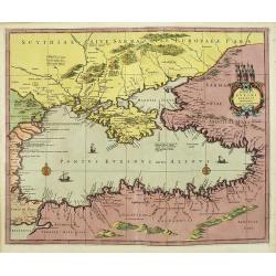
Ponti euxini cum periplus auctore N.Sanson.
A very rare map of the Black Sea area prepared by Nicolas Sanson. The map is in stunning full colors.
Date: Amsterdam, 1700
Selling price: ????
Please login to see price!
Sold in 2010
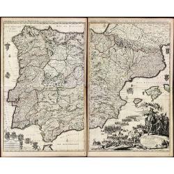
Theatre de la Guerre en Espagne et en Portugal.
A exceptional detailed wall map of Spain and Portugal with a huge beautiful designed title cartouche. Printed from 4 plates, two each already joined. Size of both sheets ...
Date: Amsterdam, 1700
Selling price: ????
Please login to see price!
Sold in 2010
A New Map of Denmark, Norway, Sweden, & Moscovy shewing their present general divisions, chief cities or towns, rivers and mountains & c.
Fine map of Scandinavia and Russia from 1700, dedicated to the Duke of Glocester. Cartouche with English coat of arms is in the upper left corner.
Date: London, 1700
Selling price: ????
Please login to see price!
Sold in 2010
Novus XVII Inferioris Germania, Proviniarum Typus.
Finely detailed map of Belgium and Holland from Merian's Topographia Germania Inferioris. Ships, sea monsters, and a pretty compass rose are depicted in the North Sea.
Date: Frankfurt, 1700
Selling price: ????
Please login to see price!
Sold in 2010
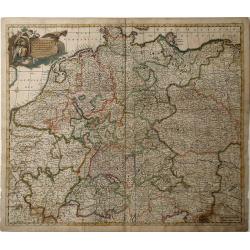
Nova et Prae Caeteris Alis Correcta Germaniae Tubula Comprehendens Accuratam X. Circulorum, Bohemiae, Regni, AC Univerfae Helvetia Defcriptionem, Cum Divifione in Caeterais Partes.
An overall map of Western Europe by Frederick De Witt which includes Saxony, France, Poland, Bohemia, and parts of Northern Italy down to the Venetian Gulf. Major cities ...
Date: Amsterdam, cira 1700
Selling price: ????
Please login to see price!
Sold in 2010
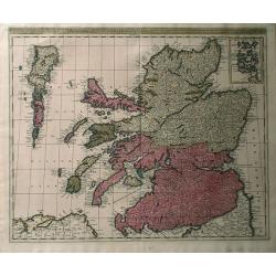
Regnun Scotiae, feu pars Septent: Magnae Brittanniae, divifa in Scotiam Septent: et Auftralem, porro autem in Comit: Rossiam Maraviam, Praefect: Lavdoniam, Renefroviam et Arandum, una cum Infulis Ebuda Occident: et Orient: Mula, Jura et Ila.
A wonderfully detailed map of Scotland and the islands off its coast by Gerard and Leonard Valk. This map includes major cities, rivers and towns, and at the top right in...
Date: Amsterdam, 1700
Selling price: ????
Please login to see price!
Sold in 2010
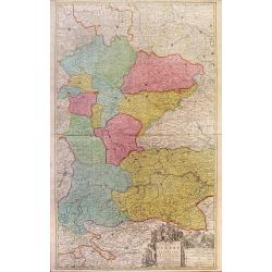
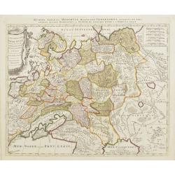
Theatre de la Guerre en Austriche, Baviere, Souabe, Le Tirol. Et le Pays aux Environs.
Colorful map of the Kingdom of Bohemia located in central Europe, present day-Czech Republic and Austria, until its dissolution in 1806. Different regions of Bohemia are ...
Date: Amsterdam, c. 1700
Selling price: ????
Please login to see price!
Sold in 2010
Partie Septentrionalo Des Pats qui sont situez entre le Rhein, la Saare, la Moselle, et la Basse Alsace.
This vibrantly colorful map focuses on the Rhine River region in southern Germany and its tributaries, extending into France. The Rhine is illustrated in the center of th...
Date: Amsterdam, c. 1700
Selling price: ????
Please login to see price!
Sold in 2010
![[No tittle] The Sea Coasts south of England and Brittany in France.](/uploads/cache/29447-250x250.jpg)
[No tittle] The Sea Coasts south of England and Brittany in France.
Detailed of the Channel with Cornwall and Brittany.
Date: London, c.1700
Selling price: ????
Please login to see price!
Sold in 2011
A New Map of Ancient Scandinavia together with as much more of y Northern Part of Ancient Europe as Anvers to Present Denmark & Moscovia
Map of Scandinavia, with an inset map of Denmark, from Edward Wells' "A New Sett Of Mapps Of Ancient And Present Geography ..." Wells was a teacher of mathemati...
Date: Oxford, 1700
Selling price: ????
Please login to see price!
Sold in 2010
Regni Poloniae et Ducatus Lithuaniae, Volinae, Podoliae, Ucraniae, Prussiae et Curlandiae . . .
Finely detailed map of the Baltic Sea region, including the regions of Poland, Hungary, Prussia, Ukraine, eastern Germany, and southwest Sweden by Frederick de Wit. Villa...
Date: Amsterdam, c.1700
Selling price: ????
Please login to see price!
Sold in 2010
A New Map of Antient Thrace: as also Of the Northern Parts of Old Greece, Macedonia and Thessalia Dedicated to His Highness William Ducke of Glocester.
Map of Thrace, a historical and geographical region in Southeast Europe, currently the area of Northern Greece and Bulgaria, including parts of Macedonia and Thesalia (no...
Date: Oxford, c. 1700
Selling price: ????
Please login to see price!
Sold in 2010
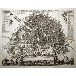
AMSTELODAMI VETERIS ET NOVISSIMAE URBIS ACCURATISSIMA DELINEATIO
SCARCE and unknown city plan of Amsterdam by or after (?) Visscher. Smaller edition of Visschers famous map of Amsterdam from ca. 1678. Embellished with numerous figures...
Date: ca. 1700
Selling price: ????
Please login to see price!
Sold in 2011
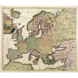
Accuratissima Europae tabula multis locis correcta. . .
Uncommon map of Europe with fine title cartouche, likely after a design by Philip Tideman.
Date: Amsterdam, c.1700
Selling price: ????
Please login to see price!
Sold in 2011
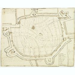
Leyden.
Manuscript fortification town-plan of Leiden, as it was at about 1670. With a numbered key (1-46) pointing to the important buildings, streets and canals in town.
Date: France, ca. 1670-1700
Selling price: ????
Please login to see price!
Sold in 2013
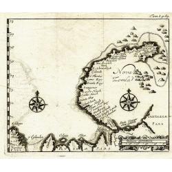
Nova Zemla.
Unknown copper-engraved map of Nowaja Semlja (Новая Земля). Shows t...
Date: ca.1700
Selling price: ????
Please login to see price!
Sold in 2011
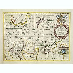
A new map of Sarmatia Europaea Pannonia and Dacia. . .
Decorative map of the region between the Baltic, Adriatic and Black Seas. This decorative map was part of a set of 22 maps dedicated to William, Duke of Gloucester, who w...
Date: Oxford, 1700
Selling price: ????
Please login to see price!
Sold in 2011
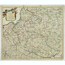
Regni Poloniae et Ducatus Lithuaniae Voliniae..
Rare map issued by Justus Danckerts attractive map of Poland and Lithuania.Decorative title cartouche upper left hand corner.The map has strong original coloring, the tit...
Date: Amsterdam, 1700
Selling price: ????
Please login to see price!
Sold in 2011
Europe.
General map of Europe. From Description de tout l'Univers, published by François Halma.
Date: Amsterdam, 1700
Selling price: ????
Please login to see price!
Sold in 2011
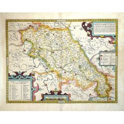
Northamptoniae Comitatus Descriptio.
This rare and important map is one of a series of county maps attributed to William Smith the antiquarian, each lacking the cartographer's name and consequently often ref...
Date: London, 1700
Selling price: ????
Please login to see price!
Sold in 2013