Browse Listings in Europe
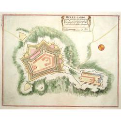
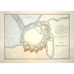
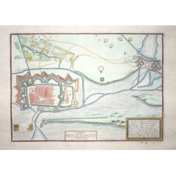
Belle-Garde.
Nice plan of Belle-Garde.
Date: Paris 1696
Selling price: ????
Please login to see price!
Sold
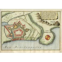
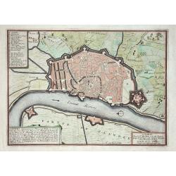
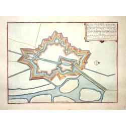
Roses.
Nice city plan of Roses in Spain.
Date: Paris 1696
Selling price: ????
Please login to see price!
Sold
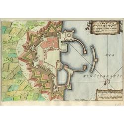
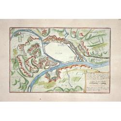
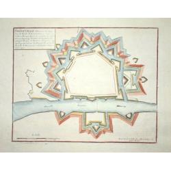
Civita-Vechia.
Nice city plan of Huningue at the Rhine river.
Date: Paris 1696
Selling price: ????
Please login to see price!
Sold
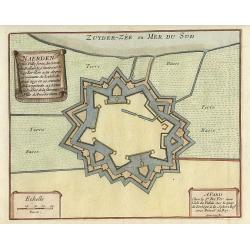
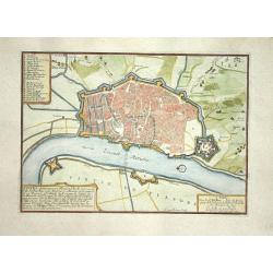
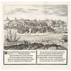
Naerden.
Nice plan of Naarden.
Date: Paris 1696
Selling price: ????
Please login to see price!
Sold
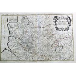
Le Comte d' Artois. Paris, 1693.
Alexis-Hubert Jaillot (1632-1712), French cartographer. He joined the Sanson heirs and redrew Nicolas Sanson's maps on a larger scale. "Atlas Nouveau" (1674), s...
Date: Amsterdam, 1696
Selling price: ????
Please login to see price!
Sold
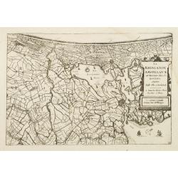
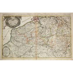
La Rhinlande Amstellande et Terres Circovosines..
Attractive map of the province of Holland, from the atlas "de Vyerighe Colom".
Date: Amsterdam, 1696
Selling price: ????
Please login to see price!
Sold
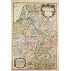
Le Cours de la Riviere du Rhein / depuis sa Source a son Embouchure./ A Paris, 1692.
Alexis-Hubert Jaillot (1632-1712), French cartographer. He joined the Sanson heirs and redrew Nicolas Sanson's maps on a larger scale. 'Atlas Nouveau' (1674), sea-atlas '...
Date: Amsterdam, 1696
Selling price: ????
Please login to see price!
Sold
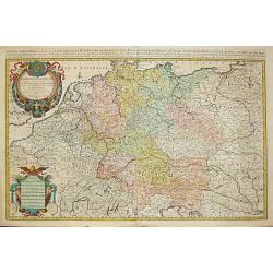
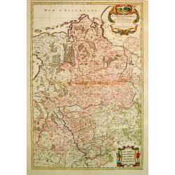
L\' Empire d\' Allemagne / distingue suivant l\' etendue de tous / les Estats, Principautes et Souverainetes. A Paris, 1696.
Alexis-Hubert Jaillot (1632-1712), French cartographer. He joined the Sanson heirs and redrew Nicolas Sanson's maps on a larger scale. 'Atlas Nouveau' (1674), sea-atlas '...
Date: Amsterdam, 1696
Selling price: ????
Please login to see price!
Sold in 2010
Le Duche et Gouvernement de Normandie divisee en Haute et Basse Normandie. Paris, 1695.
Alexis-Hubert Jaillot (1632-1712), French cartographer. He joined the Sanson heirs and redrew Nicolas Sanson's maps on a larger scale. 'Atlas Nouveau' (1674), sea-atlas '...
Date: Amsterdam, 1696
Selling price: ????
Please login to see price!
Sold
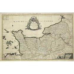
Le Comte de Flandre / divise en ses / Chastellenies et Balliages &c / le Franc de Bruges et le Pays de Waes. A Paris, 1696.
Alexis-Hubert Jaillot (1632-1712), French cartographer. He joined the Sanson heirs and redrew Nicolas Sanson's maps on a larger scale. 'Atlas Nouveau' (1674), sea-atlas '...
Date: Amsterdam, 1696
Selling price: ????
Please login to see price!
Sold in 2010
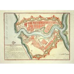
Brest
Nice city plan of Brest with the fortificationwalls and the chateau.
Date: Paris 1696
Selling price: ????
Please login to see price!
Sold
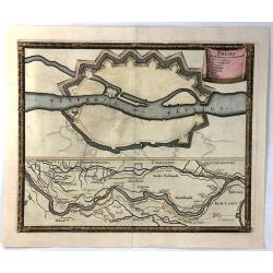
Manheim
Small city plan of Manheim with the fortification walls at the Rhine river.
Date: Paris 1696
Selling price: ????
Please login to see price!
Sold
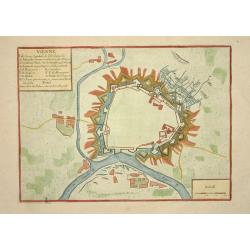
Vienne
Nice city plan of Vienna with the fortificationwalls.
Date: Paris 1696
Selling price: ????
Please login to see price!
Sold
Corso del Reno, Parte Meridionale.
Vicenzo Maria Coronelli (1650-1718), Franciscan Friar and cosmographer of Venice. Made many globes. Most famous work is his atlas 'Atlante Veneto' (1690-96).A map of Swit...
Date: Venice, 1696
Selling price: ????
Please login to see price!
Sold
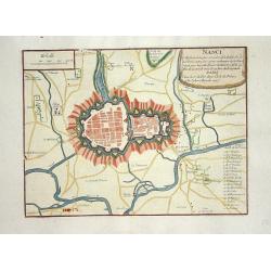
Nanci.
Nice city plan of Nancy with all rivers and canals around the city.
Date: Paris 1696
Selling price: ????
Please login to see price!
Sold
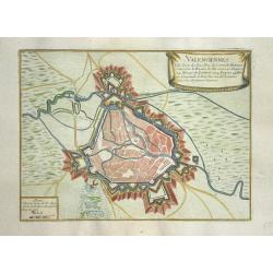
Valenciennes
Nice city plan of Valenciennes.
Date: Paris 1696
Selling price: ????
Please login to see price!
Sold
Anvers
Nice city plan of Antwerp.
Date: Paris 1696
Selling price: ????
Please login to see price!
Sold
Namur
Nice city plan of Namen.
Date: Paris 1696
Selling price: ????
Please login to see price!
Sold
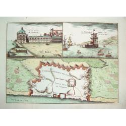
Lisbonne
A very decorative, beautifully engraved plan of Lisbon. The work identifies the boundaries of the ancient section of Lisbon within its greater contemporary (i.e., 17th c...
Date: Paris, ca. 1696
Selling price: ????
Please login to see price!
Sold
Anvers
Nice city plan of Antwerp.
Date: Paris 1696
Selling price: ????
Please login to see price!
Sold
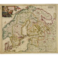
Accuratissima..Sueciae, Daniae et Norvegiae, Tabula.
Signed lower right with privilege. A delicately colored map of Scandinavia with a large title cartouche.
Date: Amsterdam 1696
Selling price: ????
Please login to see price!
Sold
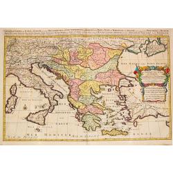
Estats / de l' Empire de Turcs / en Europe.
Alexis-Hubert Jaillot (1632-1712), French cartographer. He joined the Sanson heirs and redrew Nicolas Sanson's maps on a larger scale. 'Atlas Nouveau' (1674), sea-atlas '...
Date: Amsterdam, 1696
Selling price: ????
Please login to see price!
Sold
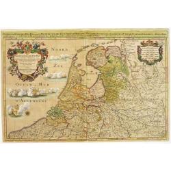
Provinces-Unies des Pays-Bas..
A large and most beautifully colored title cartouche with fighting ships on the sea: a very decorative map, prepared by N.Sanson.Because of its dimensions the map was eng...
Date: Paris, 1696
Selling price: ????
Please login to see price!
Sold in 2008
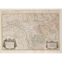
Seconde Partie du Gouvernement General de l\' Isle de France, ou la Generalite de Paris. Paris, 1692.
Alexis-Hubert Jaillot (1632-1712), French cartographer. He joined the Sanson heirs and redrew Nicolas Sanson's maps on a larger scale. 'Atlas Nouveau' (1674), sea-atlas '...
Date: Amsterdam, 1696
Selling price: ????
Please login to see price!
Sold in 2013
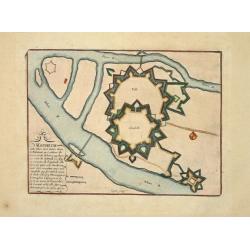
Conde
Small city plan of Conde with the fortification walls.
Date: Paris 1696
Selling price: ????
Please login to see price!
Sold
Sas de Gand
Small city plan of Sas van Gent with the fortification walls.
Date: Paris 1696
Selling price: ????
Please login to see price!
Sold
Maubeuge
Small city plan of Maubeuge with the fortification walls.
Date: Paris 1696
Selling price: ????
Please login to see price!
Sold
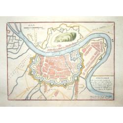
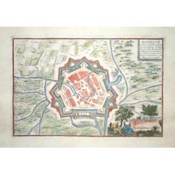
Grenoble.
Nice city plan of Grenoble.
Date: Paris 1696
Selling price: ????
Please login to see price!
Sold
Calais.
Nice city plan of Calais.
Date: Paris 1696
Selling price: ????
Please login to see price!
Sold
Thionville.
Nice city plan of Thionville.
Date: Paris 1696
Selling price: ????
Please login to see price!
Sold
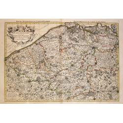
Les provinces des Pays-Bas Catholique. A Paris, 1696.
Alexis-Hubert Jaillot (1632-1712), French cartographer. He joined the Sanson heirs and redrew Nicolas Sanson's maps on a larger scale. 'Atlas Nouveau' (1674), sea-atlas '...
Date: Amsterdam, 1696
Selling price: ????
Please login to see price!
Sold in 2020
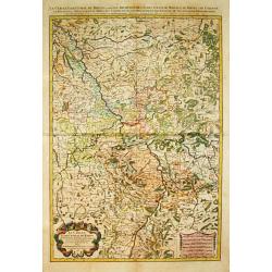
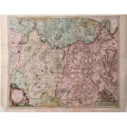
Le Cercle de Westphalie / divise en tous ses / estats et souverainetes. A Paris, 1692.
Alexis-Hubert Jaillot (1632-1712), French cartographer. He joined the Sanson heirs and redrew Nicolas Sanson's maps on a larger scale. 'Atlas Nouveau' (1674), sea-atlas '...
Date: Amsterdam, 1696
Selling price: ????
Please login to see price!
Sold in 2010
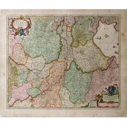
Le Cercle Eslectoral du Rhein. Paris, 1692.
Alexis-Hubert Jaillot (1632-1712), French cartographer. He joined the Sanson heirs and redrew Nicolas Sanson's maps on a larger scale. 'Atlas Nouveau' (1674), sea-atlas '...
Date: Amsterdam, 1696
Selling price: ????
Please login to see price!
Sold in 2014
![[2 sheets] Parte settentrionale del regno d'inghilterra.. [with] Parte Meridionale der regno . . .](/uploads/cache/23871-250x250.jpg)
[2 sheets] Parte settentrionale del regno d'inghilterra.. [with] Parte Meridionale der regno . . .
Matching set of 2 attractive large folio maps depicting the northern and southern parts of England. Including four large cartouches and table of counties, towns, etc. Sho...
Date: Venice, 1696
Selling price: ????
Please login to see price!
Sold in 2015
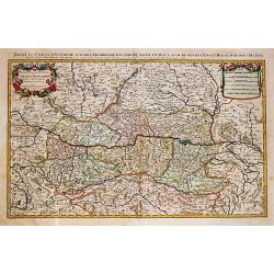
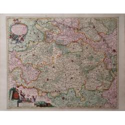
Partie du Cercle d' Austriche / scavoir / l' Archduche d' Austriche / divise en Haute et Basse. / A Paris, 1692.
Alexis-Hubert Jaillot (1632-1712), French cartographer. He joined the Sanson heirs and redrew Nicolas Sanson's maps on a larger scale. 'Atlas Nouveau' (1674), sea-atlas '...
Date: Amsterdam, 1696
Selling price: ????
Please login to see price!
Sold in 2020
Plan de la Fortresse de Portolongone en l'Ysle Delbe...
Exceedingly rare plan of Porto Longone, also known as Porto Azzurro, on the Island of Elba. Published in Les Glorieuses Conquestes de Louis le Grand - one of the most imp...
Date: Paris, 1696
Selling price: ????
Please login to see price!
Sold in 2010
Ducatus Brabantia divise in Hispanicam et Batavam?
Carol Allard map of Dutch and Belgium Brabant and Holland with beautiful original color. Shows from cities of Breda, Holland in the north to Namen, Belgium in the south.
Date: Amsterdam, 1696
Selling price: ????
Please login to see price!
Sold in 2010
Noviffima Comitatus Zutphaniae, Totiufa Fluminis Isulae Descriptio.
A map by Nicholas Visscher from his Atlas Minor showing the regions between Emmerick, Germany and Kampen. Major rivers, lakes and cities are depicted, and the map feature...
Date: Amsterdam, 1696
Selling price: ????
Please login to see price!
Sold in 2010
Ducatus Lutzenburgi, Noviffima et Accuratiffima Delinatio
A map of Luxembourg by Nicholas Visscher from his Atlas Minor which includes the towns of Namur, Liege, Trier and Metz, as well as major rivers. A detailed cartouche feat...
Date: Amsterdam, 1696
Selling price: ????
Please login to see price!
Sold in 2010
Ducatus Geldriae et Zutphaniae Comitatus
Map of Gelderland by Nicholas Visscher from his "Atlas Minor Sive Geographica". This map depicts major cities such as Buren, Grol, and Alphen and includes dynam...
Date: Amsterdam, 1696
Selling price: ????
Please login to see price!
Sold in 2010
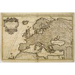
L'Europe divisee suivant l'estendue de ses principaux estats. . .
Fine map of Europe with a decorative title and scale cartouche.Alexis-Hubert Jaillot (1632-1712), was a French cartographer. He joined the Sanson heirs and redrew Nicolas...
Date: Amsterdam, 1696
Selling price: ????
Please login to see price!
Sold
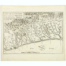
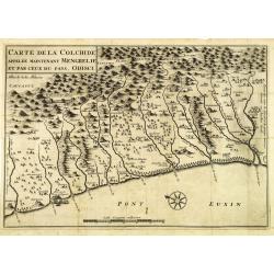
Carte de la Colchide appelée maintenant Mengrelie et pars ceux du pays Odisci.
An early map showing the extent of the fortifications of the Ottoman Empire along the east of the Black Sea and in the foothills of the Caucasus. Vignettes of buildings, ...
Date: Paris, 1664-1696
Selling price: ????
Please login to see price!
Sold in 2011
Lituania dedicata all. Illustrissimo signore Gio. Pietro Caualli secretario della serenissima Republica di ...
A scarce and very attractive detailed map of Lithuania and parts of Poland and the Baltic and includes numerous coats of arms in the body of the map and two large decorat...
Date: Venice, 1696
Selling price: ????
Please login to see price!
Sold in 2011
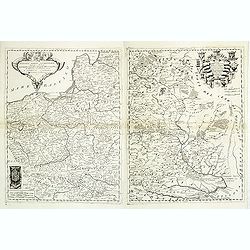
Polonia parte occidentale, Descritta, e Dedicata Dal P.Mae
A scarce and very attractive detailed map of Poland in two un-joined sheets and includes numerous coats of arms in the body of the map and a large decorative title cartou...
Date: Venice, 1696
Selling price: ????
Please login to see price!
Sold in 2011
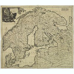
Accuratissima regnorum Sueciae, Daniae et Norvegiae, Tabula.
Uncommon map of Scandinavia with a large title cartouche in upper left corner. Signed lower right with privilege.Including Sweden, Denmark, Norway and small part of Russi...
Date: Amsterdam, 1696
Selling price: ????
Please login to see price!
Sold in 2011
Lituania dedicata all. Illustrissimo signore Gio. Pietro Caualli secretario della serenissima Republica di ...
A scarce and very attractive detailed map of Lithuania and parts of Poland and the Baltic and includes numerous coats of arms in the body of the map and two large decorat...
Date: Venice, 1696
Selling price: ????
Please login to see price!
Sold in 2012
![Pianta della Forterra d'ATENE. . . [Athens]](/uploads/cache/31821-250x250.jpg)
Pianta della Forterra d'ATENE. . . [Athens]
A scarce town-plan showing the fortress and city of Athens, mainly concentrating on classical sites within the city, with a very fine separately printed border consisting...
Date: Venice, 1696
Selling price: ????
Please login to see price!
Sold in 2012
Isola e Regno di Candia. . .
A scarce and very attractive detailed two sheet map of Crete within wide garland of vines incorporating the names of 100 Cretan towns, coat-of-arms of Cardinal d' Estrée...
Date: Venice, 1696
Selling price: ????
Please login to see price!
Sold in 2012
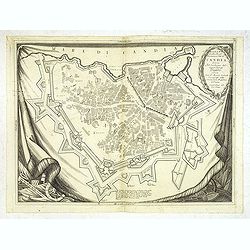
Pianta Della Real Fortezza e Citta di Candia. . .
City of Candia showing its fortifications. A beautifully ornate map with a rich, dark impression and a decorative border depicted as a hanging tapestry.The remarkable Vin...
Date: Venice, 1696
Selling price: ????
Please login to see price!
Sold
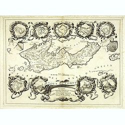
Isola di Corfu.
One of the most attractive maps of the island of Corfu ever produced. The central map is surrounded by nine plans and views of fortified locations and the ancient city of...
Date: Venice, 1696
Selling price: ????
Please login to see price!
Sold in 2014
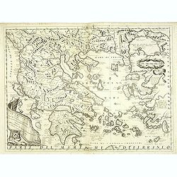
La Grecia descritta dal P. M. Coronelli Cosmografo della Serenissima Repubblica si Venezia dedicata all'Eccellenza del Signor Giovanni Lando.
Map of Greece and its islands in the Aegean and Adriatic Seas. The remarkable Vincenzo Coronelli (1650-1718), encyclopaedist, geographer, inventor and Doctor of Theology,...
Date: Venice, 1696
Selling price: ????
Please login to see price!
Sold in 2012
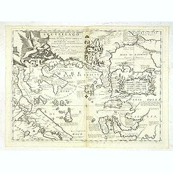
Paralello geo grafico dell'antico col moderno Arcipelago
A beautiful and rare map showing the Marmara Sea or Sea of Marmora (ancient Propontis), inland sea, north-western Turkey, connected to the Black Sea by the Bosporus Strai...
Date: Venice, 1696
Selling price: ????
Please login to see price!
Sold in 2012
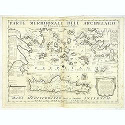
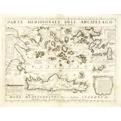
Parte Meridionale deli Archipelago. . .
A scarce and very attractive detailed map of Crete and the Aegean Sea. Forming a set with lot 31826The remarkable Vincenzo Coronelli (1650-1718), encyclopaedist, geograph...
Date: Venice, 1696
Selling price: ????
Please login to see price!
Sold in 2012
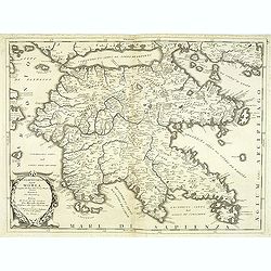
Peloponneso hoggidi Morea. . .
Decorative and highly detailed map of Morea, southern Greece with title cartouche lower left.The remarkable Vincenzo Coronelli (1650-1718), encyclopaedist, geographer, in...
Date: Venice, 1696
Selling price: ????
Please login to see price!
Sold in 2013
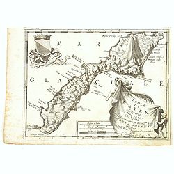
Isola di S. Maura.
A scarce and very attractive detailed map of S. Maura, with a dedication to Matteo Sanudo. With inset map. The remarkable Vincenzo Coronelli (1650-1718), encyclopaedist, ...
Date: Venice, 1696
Selling price: ????
Please login to see price!
Sold
Carte de la Colchide appelée maintenant Mengrelie et par ceux du pays Odisci.
An early map showing the extent of the fortifications of the Ottoman Empire along the east of the Black Sea and in the foothills of the Caucasus. Vignettes of buildings, ...
Date: Paris, 1664-1696
Selling price: ????
Please login to see price!
Sold in 2012
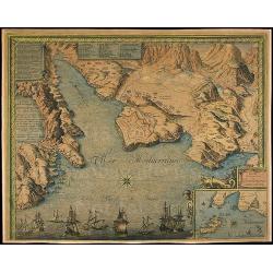
La costa d'Italia da Porto Hercole sino a C. dell'Arme et una parte di Sicilia et Sardinia.
Elaborate and scarce chart of the Tyrrhenian Sea with the north coast of Sicily and the east coast of Sardinia originally made for "Prima Parte dello Specchio del Ma...
Date: Venice, 1696
Selling price: ????
Please login to see price!
Sold in 2012
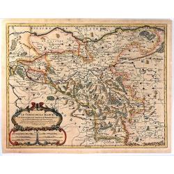
Il Monferrato. . .
A beautiful and flamboyantly engraved large-scale map of Monferrato including the towns of Turin, Casale, Alessandria, Ovada, etc. The map is the product of the late 17th...
Date: Venice, ca. 1696
Selling price: ????
Please login to see price!
Sold in 2015
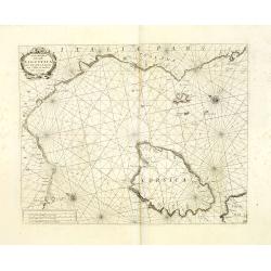
Carta Maritima della Costa Ligustica fra C. delle Melle e M. Argentato con l'Isola di Corsica et altre circonvicine. . .
A beautiful and flamboyantly engraved large-scale sea, showing Corsica and Mediterranean Sea. On verso Italian letter press and engraved plans of Antibes (130x160mm.) and...
Date: Venice, 1696
Selling price: ????
Please login to see price!
Sold in 2012
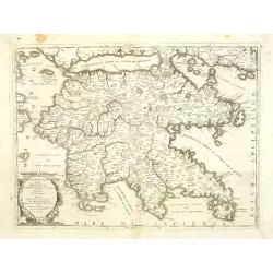
Peloponneso, hoggidi Morea,. . .
A beautiful and flamboyantly engraved large-scale map of Morea, who was in 1683 invaded by the Venetians. The map carries a dedication to Marcello Sacchetti, ambassador f...
Date: Venice, ca. 1696
Selling price: ????
Please login to see price!
Sold
Parte meridionale dell' Arcipelago . . .
A beautiful and flamboyantly engraved large-scale map of mediterranean islands and in bottom a map of Crete. On verso a map of "Sdilles Grande olim Rhenaea Insula. ....
Date: Venice, ca. 1696
Selling price: ????
Please login to see price!
Sold
La Guienna, Medoc, Saintonge, Aunis. . .
A beautiful and flamboyantly engraved large-scale map of southwest of France with Bordeaux region with the Isles De Re and Oleron, and an inset plan of the fortified port...
Date: Venice, ca. 1696
Selling price: ????
Please login to see price!
Sold
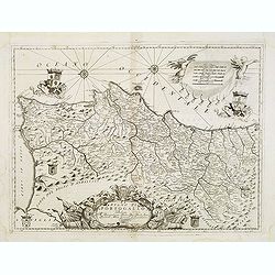
Regno di Portogallo. . .
A beautiful and flamboyantly engraved large-scale map of Portugal. On verso a map of Lisbon "S Giovanni di Lisbona" (128x162mm.)The map is the product of the la...
Date: Venice, ca. 1696
Selling price: ????
Please login to see price!
Sold in 2013
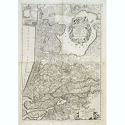
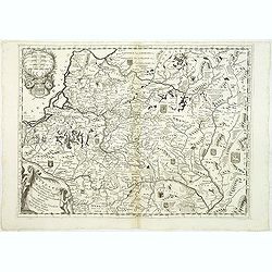
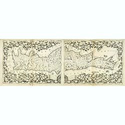
Contado d'Ollanda parte settentrionale / Contado d'ollanda parte meridionale. . .
A beautifully engraved two-sheet map of Holland locating the cities of Leiden, The Hague, Delft, Rotterdam, Breda, Utrecht, Amersfoort, s'Hertogenbosch, etc. The region i...
Date: Venice, ca. 1696
Selling price: ????
Please login to see price!
Sold in 2012

Nisen Navgorod.
An early of Nizhniy Novgorod (Gorky) on the Oka and Volga river. From the scarce Hamburg edition "Viel Vermehrte Moscowitische und Persianische Reisebeschreibung&qu...
Date: Hamburg, 1696
Selling price: ????
Please login to see price!
Sold

Kremelin Das Schloß in Muscau.
An early of the Kremlin in Moscow. From the uncommon Hamburg edition "Viel Vermehrte Moscowitische und Persianische Reisebeschreibung" by Adam Olearius.Underne...
Date: Hamburg, 1696
Selling price: ????
Please login to see price!
Sold in 2013
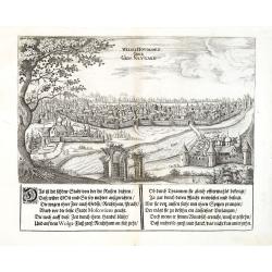
Weliki Novogord oder Gros-Navgard.
An early of tVeliki Novgorod. From the scarce Hamburg edition "Viel Vermehrte Moscowitische und Persianische Reisebeschreibung" by Adam Olearius.Underneath the...
Date: Hamburg, 1696
Selling price: ????
Please login to see price!
Sold in 2013
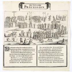
Eine Moscowitische Procession.
An view of a procession in Moscow. From the scarce Hamburg edition "Viel Vermehrte Moscowitische und Persianische Reisebeschreibung" by Adam Olearius.Underneath...
Date: Hamburg, 1696
Selling price: ????
Please login to see price!
Sold in 2023
Nisen Navgorod.
An early of Nizhniy Novgorod (Gorky) on the Oka and Volga river. From the scarce Hamburg edition "Viel Vermehrte Moscowitische und Persianische Reisebeschreibung&qu...
Date: Hamburg, 1696
Selling price: ????
Please login to see price!
Sold

Prospectus Euripi e Palatio Rosersberg.
Two striking copper engravings featuring the Rosersberg Palace. Engraved by Swiddle in 1696.Count Erik Dahlberg (1625-1703) was a Swedish soldier, engineer and graphic a...
Date: Stockholm, 1696
Selling price: ????
Please login to see price!
Sold in 2017
Frislanda, Scoperta da Nicolo Zeno Patritio Veneto Creduta Favolosa, o nel Mare Somersa . . .
A fine map of the mythical island of "Frislandia", based upon the writings of Nicolo Zeno.Frislanda, which was purportedly discovered by the Zeno brothers in a ...
Date: Venice, 1696
Selling price: ????
Please login to see price!
Sold in 2013
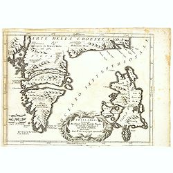
Isola Di Mayen Scoperta l'Anno 1614 . . .
A fine map of Jan Mayen Island, which was discovered in 1614 by a Dutch whaling captain, northeast of Iceland.A large volcano is shown. The map has many Dutch names.The r...
Date: Venice, 1696
Selling price: ????
Please login to see price!
Sold in 2020
![Contado d'Ollanda parte settentrionale / Contado d'ollanda parte meridionale. . . [two sheet map]](/uploads/cache/34725-250x250.jpg)
Contado d'Ollanda parte settentrionale / Contado d'ollanda parte meridionale. . . [two sheet map]
A beautifully engraved two-sheet map of Holland locating the cities of Leiden, The Hague, Delft, Rotterdam, Breda, Utrecht, Amersfoort, s'Hertogenbosch, etc. The region i...
Date: Venice, ca. 1696
Selling price: ????
Please login to see price!
Sold in 2020
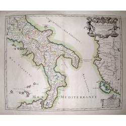
Le Royaume De Naples Divisé En Douze Provinces.
Striking large and highly detailed map of southern Italy, from Rome until Sicily. Including parts of Albania and Greece with Corfu. Also including many small islands: Tre...
Date: Paris, 1696
Selling price: ????
Please login to see price!
Sold in 2014
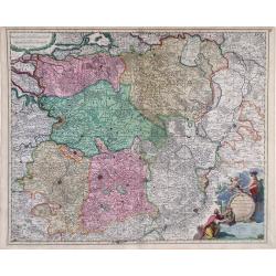
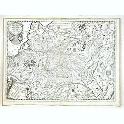
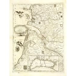
Le Comte de la Marck, les Seigneuries des Abbayes de Werden, d'Essen et la Ville Imperiale de Dortmundt
A detailed map of the Ruhrgebiet region in western Germany between Duisburg, Hamm and Olpe. With a decorative cartouche incorporating scale of miles. Published by Chez Hu...
Date: Paris, 1696
Selling price: ????
Please login to see price!
Sold in 2016
Simie, Piscopia, Nisari.
Three maps of Symi, Telos and probably Nisiros in the south Aegean Sea. Large sheet with the three maps and lengthy Italian text about the islands. From Coronelli's famou...
Date: Venice, 1696
Selling price: ????
Please login to see price!
Sold in 2015
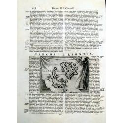
Carchi e Limonia.
Early map of the islands of Halki and Alimia near Rhodes. The map is set on a sheet with italian text, printed on both sides.
Date: Venice, 1696
Selling price: ????
Please login to see price!
Sold in 2015
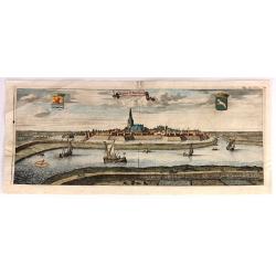
De Stad St. Maertens Dyke.
Decorative panoramic view of the town of St. Maartendijk, from "M. Smallegange Cronyk van Zeeland". The city view features a banner title cartouche with two her...
Date: Middelburg, Amsterdam, 1696
Selling price: ????
Please login to see price!
Sold in 2017
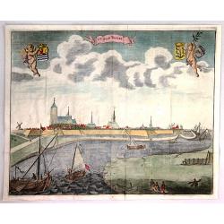
De Stad Tholen
A fine plan of the Dutch town of Tholen in the province of Zeeland. It features two putti holding coats of arms. There are several ships in the foreground. Engraved by Ma...
Date: Amsterdam, 1696
Selling price: ????
Please login to see price!
Sold in 2018
Brema Cum Situatione Circumiacente
Two engravings of Bremen on one print. The upper engraving shows a birds-eye view of the fortifications of Bremen, Germany with fortifications. An index in the top right ...
Date: Nuremberg, 1696
Selling price: ????
Please login to see price!
Sold in 2016