Browse Listings in Europe
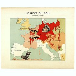
Le Rève du Fou. The madman's dream.
Scarce French satirical map of Europe in 1914 produced by A. Delaye and printed in colors by Ch. Delaye in Paris.
Date: Paris, 1914
Selling price: ????
Please login to see price!
Sold in 2018

Une bête fauve rôde sur notre frontière et bave sur la noble Belgique!! Sus à cette honte de l'Europe. N°2.
Scarce plate in original hand colors figuring Wilhelm II as a wild beast walking along the French border and drooling on Belgium. Signed and dated in the plate "G. B...
Date: Paris, 1914
Selling price: ????
Please login to see price!
Sold in 2018
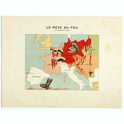
Le Rève du Fou. The madman's dream.
Scarce French satirical map of Europe in 1914 produced by A. Delaye and printed in colors by Ch. Delaye in Paris. Signed and dated in the plate.The map of Europe figures ...
Date: Paris, 1914
Selling price: ????
Please login to see price!
Sold in 2018
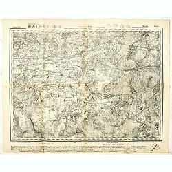
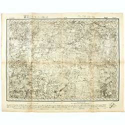
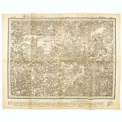
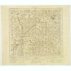
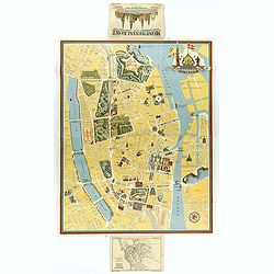
Government Minsk. - Russland 1:126,000 V. XVII.6.
Folding military topographic map of part of Belarus, issued by the General Staff of the German Army. Scale 1:126000 (3 km (Werst) in 1 inch). Centered on Sluzk.Along uppe...
Date: Germany, 1915
Selling price: ????
Please login to see price!
Sold in 2021
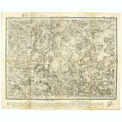
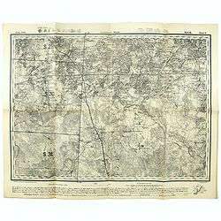
Government Minsk u. Wilna Mirr Blatt 5. - Russland 1:126,000 V. XVI.5.
Folding military topographic map of part of Belarus, issued by the General Staff of the German Army. Scale 1:126000 (3 km (Werst) in 1 inch). Centered on Mir.Along upper ...
Date: Germany, 1915
Selling price: ????
Please login to see price!
Sold in 2021
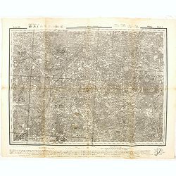
Government Minsk. Kopyl Blatt 6. - Russland 1:126,000 V. XVI.6.
Folding military topographic map of part of Belarus, issued by the General Staff of the German Army. Scale 1:126000 (3 km (Werst) in 1 inch). Centered on Schazk.Along upp...
Date: Germany, 1915
Selling price: ????
Please login to see price!
Sold in 2021
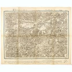
Government Minsk. Klezk Blatt 5. - Russland 1:126,000 V. XVII.5.
Folding military topographic map of part of Belarus, issued by the General Staff of the German Army. Scale 1:126000 (3 km (Werst) in 1 inch). Centered on Sinjawka.Along u...
Date: Germany, 1915
Selling price: ????
Please login to see price!
Sold in 2021
Government Wilna u. Kowno Widsy Blatt 5. - Russland 1:126,000 V. XII.5.
Folding military topographic map of part of Belarus, issued by the General Staff of the German Army. Scale 1:126000 (3 km (Werst) in 1 inch). Centered on Swenzjany.Along ...
Date: Germany, 1915
Selling price: ????
Please login to see price!
Sold in 2016
Government Minsk u Kowno. Glubokoje Blatt 6.- Russland 1:126,000 V. XII.6.
Folding military topographic map of part of Belarus, issued by the General Staff of the German Army. Scale 1:126000 (3 km (Werst) in 1 inch). Centered on Glubokoje.Along ...
Date: Germany, 1915
Selling price: ????
Please login to see price!
Sold in 2016
GovernmentWilna u. Minsk. Dokschitzy Blatt 6.- Russland 1:126,000 V. XIII.6.
Folding military topographic map of part of Belarus, issued by the General Staff of the German Army. Scale 1:126000 (3 km (Werst) in 1 inch). Centered on Budslaw.Along up...
Date: Germany, 1915
Selling price: ????
Please login to see price!
Sold in 2016
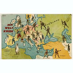
Der Weltkrieg. World War I post card)
During the Great War, when the only means of communicating news to the masses was by newspapers and weekly illustrated magazines, the ‘war’ or 'military' picture post...
Date: Germany, 1915
Selling price: ????
Please login to see price!
Sold in 2018
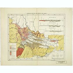
Geological map of the Donetz coal basin.
Uncommon American geological map of the Russian Donetz coal zone, published by R. Martens & Co. From New York. color key in lower left corner. The coal-field was disc...
Date: New-York, ca. 1916
Selling price: ????
Please login to see price!
Sold in 2013
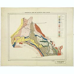
Geological map of Kuznetz coal basin.
American geological map of the Russian Kuznetsk Coal zone, published by R. Martens & Co. From New York. color key in upper The development of the coal fields of Kuzne...
Date: New-York, ca. 1916
Selling price: ????
Please login to see price!
Sold in 2012
![[Europe.]](/uploads/cache/82027-250x250.jpg)
[Europe.]
A very rare satirical map (postcard) showing Europe during first World War.
Date: Marseille, 1918
Selling price: ????
Please login to see price!
Sold in 2020
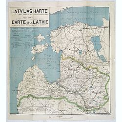
Latvijas Karte. . . Carte de la Latvie editée par le conseil national Latvien en Siberie.
One of the earliest maps showing an independent Latvia, in 1919. Estonia in upper right corner. Prepared by Luit. MantnieksOn July 21, 1919, Latvia and Estonia signed a b...
Date: Latvia, 1919
Selling price: ????
Please login to see price!
Sold in 2017
(Military map as paper for stamps of the newly formed Latvia.) No. P. 17 Birze)
The first stamps of Latvia – printed on German military maps almost 100 years ago. Military map with red 5. Kap stamps - the rarer perforated and gummed version, showin...
Date: Riga, Schnaekenburg printing, 1918-1919
Selling price: ????
Please login to see price!
Sold in 2012
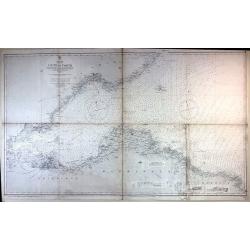
Firth of Forth, St. Abbs Head to the Forth Bridge (Maritimes Chart)
Fine large maritime chart featuring a segment of the Scottish east coast including Edinburgh, Haddington and Berwick.First published by the Admiralty in London in 1860. T...
Date: London, 1919
Selling price: ????
Please login to see price!
Sold in 2015
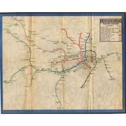
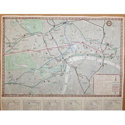
Underground Railway Map of London 1919.
One of the rarest London Underground maps. The first London Underground map produced after the end of World War One, the lines are shown with reasonable geographical accu...
Date: London, 1919
Selling price: ????
Please login to see price!
Sold in 2018
![[This is Great Brittain to-day - Cambridge]](/uploads/cache/43009-250x250.jpg)
[This is Great Brittain to-day - Cambridge]
Chromolithoghraphed plate showing a fancy depiction of the courtyard of a British University (Cambridge). A text in Arabic language explaining about the 20 universities a...
Date: Arabia, ca. 1920
Selling price: ????
Please login to see price!
Sold in 2025
![No title: [Minorca.]](/uploads/cache/16337-250x250.jpg)
No title: [Minorca.]
Geological map showing the island Minorca. Very interestingly in the lower right bottom manuscript notations in pencil with instructions for the editor, with P. Fallot's ...
Date: Paris, c. 1920
Selling price: ????
Please login to see price!
Sold in 2018
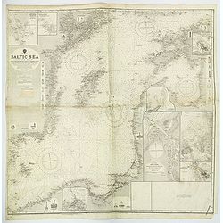
Baltic Sea Eastern SheetCompiled from Swedish German and Russian Government Surveys. . .
A large and detailed Admiralty chart first published in 1862, but with numerous revisions and editions up until 1921. Map of the Baltic Sea, covering some of the Gulf of ...
Date: London, 1921
Selling price: ????
Please login to see price!
Sold in 2019
Clubland and Theatreland, London map 1924
This colorful and highly detailed large map of London was published c.1924 by Geographia Ltd. Covers the West End (Downtown) of London from the Hammersmith Bridge and Wor...
Date: London, 1924
Selling price: ????
Please login to see price!
Sold in 2015
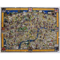
The Wonderground Map of London Town Drawn by MacDonald Gill.
In 1914, 'The Wonderground Map' was designed by MacDonald Gill and commissioned for the underground by Frank Pick, Commercial Manager of the then-Underground Electric Rai...
Date: London, 1924
Selling price: ????
Please login to see price!
Sold in 2020
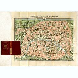
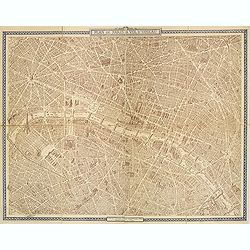
Plan commode deParis rues & monuments autobus & tramways - Guide indicateur des rues de Paris avec les stations du Métropolitain le plus proches. . .
A well-preserved copy of this charming folding map of Paris, in its original hardcover gilted red wrapper. This tourist map starts with a 162pp of index to the streets an...
Date: Paris, ca. 1925
Selling price: ????
Please login to see price!
Sold
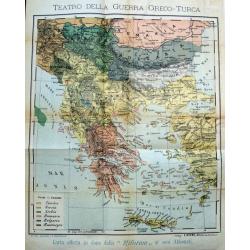
Teatro della guerra Greco-Turca.
Unusual map of South-East Europe with Greece, Romania, Bulgaria, and parts of Turkey. Coloring indicates the countries during the The Greco-Turkish War of 1919–1922. Pu...
Date: Milan, c. 1925
Selling price: ????
Please login to see price!
Sold in 2017
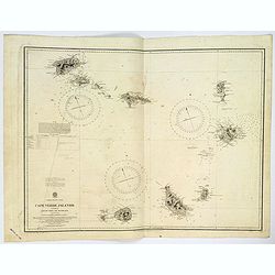
Cape Verde Islands.
A large double page sea chart of the Cape Verde Islands in the Atlantic Ocean, initially surveyed by Lieut's Vidal & Mudge, R.N. between 1819-21, and first published ...
Date: London, 1926
Selling price: ????
Please login to see price!
Sold in 2023
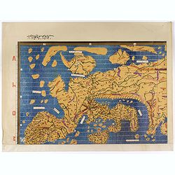
Single sheet from Tabula Rogeriana world map with European section.
Separate single sheet (of 6) with the European section of the [TABULA ROGERIANA] [NUZHAT AL-MUSHTĀQ FI'KHTIRĀQ AL-ĀFĀQ - THE BOOK OF PLEASANT JOURNEYS INTO FARAWAY LA...
Date: Suttgart, Konrad Miller, 1928
Selling price: ????
Please login to see price!
Sold in 2017
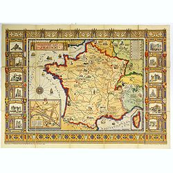
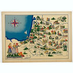
The Picture Map of France.
A large, colorful picture map of France, published by Bowker Co. in New York in 1929. The map was designed and drawn by Harold Haven Brown.This lovely map shows historica...
Date: New York, 1929
Selling price: ????
Please login to see price!
Sold in 2018
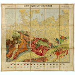
Kleine Geologische Karte von Deutschland. hrsg. von der Preussischen Geologischen Landesanstalt 1930.
Geological map (1:2.000.000) showing Germany and Poland and made by Walter Schriel (1892-1959).Printed by Berliner Lithographisches Institut, Berlin.Provenance : Foundati...
Date: Berlin, c. 1930
Selling price: ????
Please login to see price!
Sold in 2016
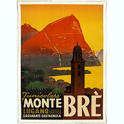
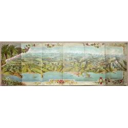
Funicolare Monte Brè Lugano Suisse. Cassarate-Catagnola.
Rare and authentic poster of Lake Lugano, situated in the Switzerland mountains, with a view of the Funicolare of Monte Brè.Designed by Otto Ernst and printed and publis...
Date: Lugano, ca. 1930
Selling price: ????
Please login to see price!
Sold in 2024

Venice scene pochoir.
Lovely art deco pochoir showing Venice, with gondolas. Very nice romantic colors.Pochoir is a technique that was often used in French Fashion Journals to illustrates cost...
Date: Paris, ca. 1930
Selling price: ????
Please login to see price!
Sold in 2025
Schönes Schlesien. / Das malerische Breslau.
Publicity leaflet for Breslau which was the capital of what was until 1945 the Prussian province of Silesia. Design by Franz Huth. On verso other touristic places to go t...
Date: Breslaw, ca. 1930
Selling price: ????
Please login to see price!
Sold in 2020
![Mer Méditerranée - Partie Ouest. [5321]](/uploads/cache/23547-250x250.jpg)
Mer Méditerranée - Partie Ouest. [5321]
Large chart centered on the western part of the Mediterranean Basin from the Strait of Gibraltar as far as the Dalmatian coast, with soundings indicated in meters.Surroun...
Date: Paris [1914] corrections to 1931
Selling price: ????
Please login to see price!
Sold
![Mer Méditerranée - Partie Est. [5322]](/uploads/cache/23548-250x250.jpg)
Mer Méditerranée - Partie Est. [5322]
Large chart centered on the eastern part of the Mediterranean, with soundings indicated in meters.Surrounded by 28 inset plans of the main European African and Asian town...
Date: Paris [1914] corrections to 1931
Selling price: ????
Please login to see price!
Sold
Mer Méditerranée - Côte de France - Golfe de la Napoule Rade de Cannes. . .
Large centered on the Gulf of La Napoule with the harbour of Cannes, the islands Sainte Marguerite and Saint Honorat on the right side. Showing towns, buildings, banks, ...
Date: Paris, 1903 updated 1931
Selling price: ????
Please login to see price!
Sold
![Mer Adriatique. Environs de Raguse (Dubrovnik). Troisième Feuille. Gravosa-Raguse-Breno.. [278]](/uploads/cache/23474-250x250.jpg)
Mer Adriatique. Environs de Raguse (Dubrovnik). Troisième Feuille. Gravosa-Raguse-Breno.. [278]
Large scale coastal chart showing a stretch of Dalmatian coast centered on Dubrovnik and covering the area from Verbitza as far as Cavtat.With 2 large inset plans illustr...
Date: Paris [1820] 1932
Selling price: ????
Please login to see price!
Sold in 2023
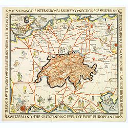
Switzerland The very Heart of Europe / and her International Railway Connections.
A fun map of a centrally positioned Switzerland, mapped in some detail, surrounded by all her many connecting train routes with her neighboring countries. Cities outside ...
Date: Zurich, 1933
Selling price: ????
Please login to see price!
Sold in 2018
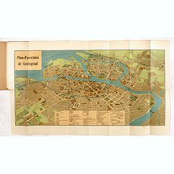
Plan-Panorama de Léningrad.
Official Intourist booklet with a panoramic plan of St. Petersburg printed in chromo-lithography, folded and kept in beige wrapper with title "PLAN-PANORAMA DE LENIN...
Date: Russia, 1931-1934
Selling price: ????
Please login to see price!
Sold in 2014
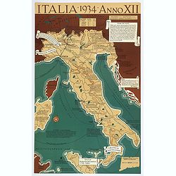
Italia, 1934, Anno XII.
A satirical look at Italy, taken from an American viewpoint, whilst it under a Fascist regime. The text describes cities and regions and directly expresses the author’s...
Date: [United States], 1934
Selling price: ????
Please login to see price!
Sold in 2018
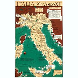
Italia 1934 - Anno XII.
A very satirical map of Italy that heavily criticizes the Fascist regime in the country, with many unflattering notes attached to places and regions. (ie SARDINIA "...
Date: Connecticut, 1934
Selling price: ????
Please login to see price!
Sold in 2021
![Entrée de la Mer Adriatique.. [2662]](/uploads/cache/23488-250x250.jpg)
Entrée de la Mer Adriatique.. [2662]
Large chart centered on the Strait of Otranto and illustrating the Salento peninsula at the Italian side as well as the northwestern coast of Albania and the northwest mo...
Date: Paris [1886] corrected for 1935
Selling price: ????
Please login to see price!
Sold in 2023
LA CÔTE D'AZUR.
Cover of an illustrated flyer. Printed by E.Imbert & Cie, Grasse -
Date: Grasse, ca. 1935
Selling price: ????
Please login to see price!
Sold in 2020
Rodi. Rhodes. Rhodos
Pictorial map of Rhodes, the island of the sun or rose island in Greece. Signed by Egon Huber Rodi 1935 on lower right. On upper right: Rodi, Rhodes, Rhodos, Rhodus. Show...
Date: Italty, 1935
Selling price: ????
Please login to see price!
Sold in 2021
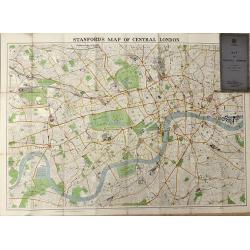
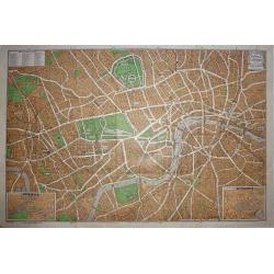
Map of Central London
A highly detailed folding map of Central London, published between the wars.
Date: London, 1936
Selling price: ????
Please login to see price!
Sold in 2016
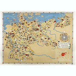
L'Allemagne au paradis du tourisme.
Iconographic map of Germany designed by Walter Riemer, published during pre world war II, by Reichsbahnzentrale. This propaganda paper was published in preparation for th...
Date: Berlin, 1936
Selling price: ????
Please login to see price!
Sold in 2017
Underground Railway Map - London Transport - Issued free - No 1 - 1938.
An interesting early London underground map. The main map shows the Metropolitan and District Lines- Piccadilly Line – Bakerloo Line – and Central line with a key to ...
Date: London, 1938
Selling price: ????
Please login to see price!
Sold in 2017
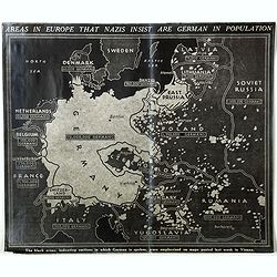
Areas in Europe that nazis insist are German in population . . .
A English propaganda broadsheet, showing a map of Europe. In the bottom "The black areas, indicating sections in which German is spoken, were emphasized on maps post...
Date: England, c. 1938
Selling price: ????
Please login to see price!
Sold in 2018
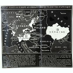
Focal points in Europe as Germany drives to end the status quo.
A very rare English propaganda broadsheet, showing a map of Europe. In the bottom a legend text corresponding to each number on the map. "Nazi agitators demand the r...
Date: England, c. 1938
Selling price: ????
Please login to see price!
Sold in 2018
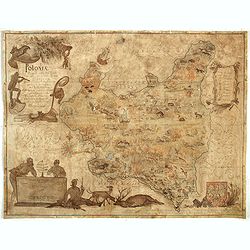
Poloniae Regni amplissimi . . .
Map of Poland drawn by E. Kanarek and T. Lipski, showing the forests and hunting grounds of the Republic of Poland. Published for privatye circulation by the Polish State...
Date: Warsaw, 1938
Selling price: ????
Please login to see price!
Sold in 2019
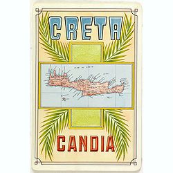
Creta Candia
Unique manuscript map of Crete. Award-winning manuscript card, prepared by Antonio Raggio for the 11th Congreso de la Union Postal Universal (World Postal Congress) Expos...
Date: Buenos Aires, 1939
Selling price: ????
Please login to see price!
Sold in 2023
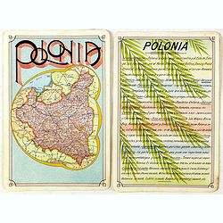
Polonia
Unique manuscript map of Poland. Award-winning manuscript card, prepared by Antonio Raggio for the 11th Congreso de la Union Postal Universal (World Postal Congress) Expo...
Date: Buenos Aires, 1939
Selling price: ????
Please login to see price!
Sold in 2020
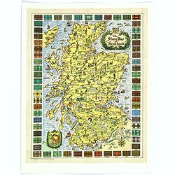
The Story Map of Scotland.
A colorful and detailemap of Scotland, showing the history of that fascinating country in pictorial form. Surrounding the map are the Tartans of 62 differnent Clans. In o...
Date: Chicago, 1939
Selling price: ????
Please login to see price!
Sold in 2016
Intourist Map of the Soviet Union and Europe Showing Principal Transportation Connections.
An interesting map - especially as it was published just before WWII. Date is based on "Intourist suggested itineraries for 1939". Soviet Union borders shown in...
Date: New York, 1939
Selling price: ????
Please login to see price!
Sold in 2019
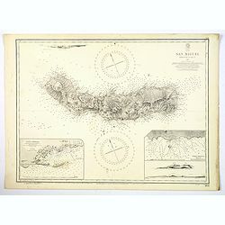
Azores. San Miguel.
A large updated sea chart of the island of San Miguel in the Azores, originally surveyed by Capt. A.T.E. Vidal, R.N. in 1844. The chart has had a few new editions, and a ...
Date: London, 1939
Selling price: ????
Please login to see price!
Sold in 2021
Plan de Paris à vol d'oiseau.
A very detailed plan of Paris for the year 1920. Design by Georges Peltier and published by Blondel la Rougery. Lower left "Ce plan dressé d'après nature est la pr...
Date: Paris, Monroco, 1920-1940
Selling price: ????
Please login to see price!
Sold in 2013
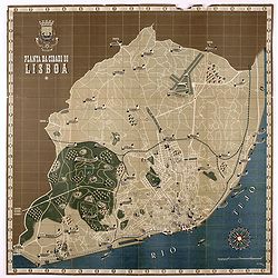
Planta da Cidade de Lisboa.
Folding pictorial plan of the city of Lisbon. This broadside features a Deco-inspired pictographic map of Lisbon on one side, by Jose Espinho, a lithograph. There are sma...
Date: Lisbon, 1940
Selling price: ????
Please login to see price!
Sold in 2021
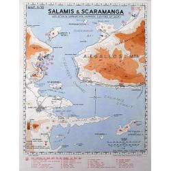
Salamis & Scaramanga.
A "Secret" map was printed by the South African Survey Co, in December 1941, after the German invasion of Greece. Shows a portion of the Saronic Gulf with the S...
Date: South Africa, 1941
Selling price: ????
Please login to see price!
Sold in 2016
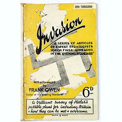
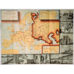
Invasion. A Series of Articles by Expert Strategists with 9 maps.
An interesting small quarto sized 64 page booklet covering Invasion, a series of articles by expert strategists which first appeared in The Evening Standard.A brilliant s...
Date: London / Melbourne, ca. 1941
Selling price: ????
Please login to see price!
Sold in 2017
Azores. Fayal Pico and San Jorge.
A large updated sea chart of Fayal (Faial) Pico and San Jorge in the Azores Archipelago in the Atlantic Ocean, first survey in 1844 by Capt. A.T.E. Vidal, R.N. The chart ...
Date: London, 1941
Selling price: ????
Please login to see price!
Sold in 2020
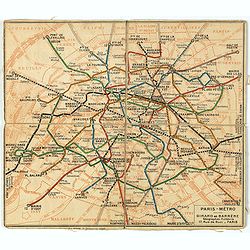
Plan de métro de Paris par Girard et Barrère. Edition de 1942
Miniature metro map of Paris, published by Girard et Barrère, Géographes - Editeurs, 17 rue de Buei, Paris.
Date: Paris, 1942
Selling price: ????
Please login to see price!
Sold in 2020
Basque - Bearn - Bigorre.
Very decorative, informative map of Basque - Bearn - Bigorre in south western France. Including the towns of Biarritz, Dax, Bayonne, Lourdes, etc. The map is filled with ...
Date: France, 1943
Selling price: ????
Please login to see price!
Sold in 2013
Basque - Bearn - Bigorre.
Very decorative, informative map of Basque - Bearn - Bigorre in south western France. Including the towns of Biarritz, Dax, Bayonne, Lourdes, etc. The map is filled with ...
Date: France, 1943
Selling price: ????
Please login to see price!
Sold in 2014
Basque - Bearn - Bigorre.
Very decorative, informative map of Basque - Bearn - Bigorre in south western France. Including the towns of Biarritz, Dax, Bayonne, Lourdes, etc. The map is filled with ...
Date: France, 1943
Selling price: ????
Please login to see price!
Sold in 2016
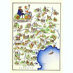
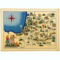
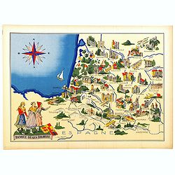
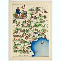
Languedoc - Foix Roussillon.
Very decorative, informative map of Languedoc - Foix Roussillon region in south eastern France. Including the towns of Carcassonne, Montpellier,, Albi, Toulouse, etc.The ...
Date: France, 1943
Selling price: ????
Please login to see price!
Sold in 2016
Languedoc - Foix Roussillon.
This is a very decorative, informative map of the Languedoc - Foix Roussillon region in southeastern France, including the towns of Carcassonne, Montpellier,, Albi, Toulo...
Date: France, 1943
Selling price: ????
Please login to see price!
Sold in 2023
Languedoc - Foix Roussillon.
Very decorative, informative map of Languedoc - Foix Roussillon region in south eastern France. Including the towns of Carcassonne, Montpellier,, Albi, Toulouse, etc.The ...
Date: France, 1943
Selling price: ????
Please login to see price!
Sold in 2022
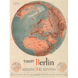
Target Berlin
This large map (broadside) is formally entitled Newsmap. Monday, October 25, 1943, Vol. II No. 27. By F. E. Manning, it is one of the most iconic American WWII propaganda...
Date: Washington D.C., 1943
Selling price: ????
Please login to see price!
Sold in 2023
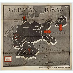
German Jigsaw.
BONUS Map depicting Germany separated into a jigsaw puzzle. "Enlargement of original map drawn for TIME the weekly news magazine" according to note in right han...
Date: New York , Time Magazine, 1944
Selling price: ????
Please login to see price!
Sold in 2017
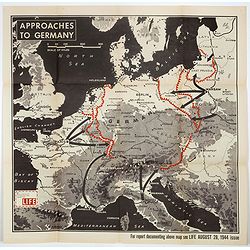
Approaches to Germany.
BONUS Map depicting possible routes into Germany from Russia, France, and Italy. "Enlargement of original map drawn for LIFE" according to note in lower left co...
Date: New York , Time Magazine, 1944
Selling price: ????
Please login to see price!
Sold in 2018
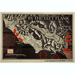
By the Left Flank.
Map depicting central Italy, just south of Rome. Design by Robert Macfarlane Chapin Jr.. In lower left hand side : Enlargement of original map drawn for TIME The Weekly N...
Date: New York , Time Magazine, 1944
Selling price: ????
Please login to see price!
Sold in 2017
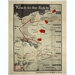
Reach to the Reich.
Map depicting central Italy, just south of Rome. Design by Robert Macfarlane Chapin Jr.. In lower left hand side : Enlargement of original map drawn for TIME The Weekly N...
Date: New York , Time Magazine, 1944
Selling price: ????
Please login to see price!
Sold in 2017

The soldiers of the Netherlands Underground Forces greet the Soldiers of the United Nations.
A poster in English and Dutch designed by Frederick Henri Kay Henrion and printed in lithography right after the liberation. Bi-langual poster: "The soldiers of the ...
Date: Smeets, Weert, 1945
Selling price: ????
Please login to see price!
Sold in 2017
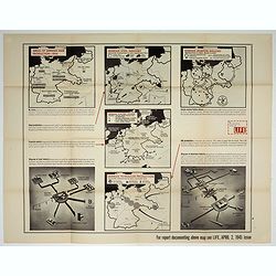
Germany's critical minerals
BONUS Map depicting 5 maps showing German steel, airplane, petroleum, etc. production around 1944. Design by Jerry Muscott (Enlargement reprint for Life Magazine, April 2...
Date: New York , Life Magazine, 1945
Selling price: ????
Please login to see price!
Sold in 2017
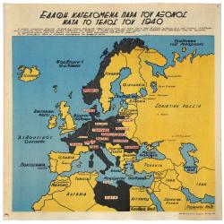
TERRITORIAL GAINS OF THE AXIS POWERS END OF 1940 (WWII Greek Language Propaganda Map)
Hitler, having remedied all losses suffered by Germany under the Treaty of Versailles, started to bring under the authority of the Third Reich all German-speaking peoples...
Date: Alexandria, 1945
Selling price: ????
Please login to see price!
Sold in 2021
Kobenhavn / North Seeland.
A nice, large, colorful town plan of the Danish capital, published in 1946. The map covers in some detail from the central train station and the Tivoli Gardens, north up ...
Date: Kobenhavn, 1946
Selling price: ????
Please login to see price!
Sold in 2018
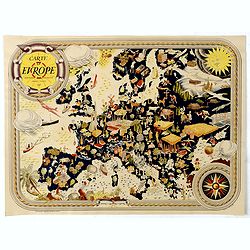
Carte D'Europe - Editions Jacques Petit.
Very decorative large pictorial map of Europe designed in 1946 by Pierre Herault and published in Angers by Editions Jacques Petit in 1955. The separate issued map shows ...
Date: Angers, 1946
Selling price: ????
Please login to see price!
Sold in 2019
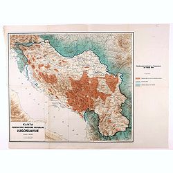
Karta Federativne Narodne Republike Jugoslavije.
Rare map of Yugoslavia. With color key. The map was made in the year of the 1941 invasion of Yugoslavia, also known as the April War was a German-led attack on the Kingdo...
Date: Yugoslavia, 1946
Selling price: ????
Please login to see price!
Sold in 2021
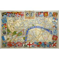
Royal Wedding. The Daily Telegraph Picture Map of the Route.
The Royal Wedding of Princess Elizabeth and Philip Mountbatten was on November 20, 1947. "Map Produced for the "Daily Telegraph" by H.A. & W.L. Pitkin ...
Date: London, 1947
Selling price: ????
Please login to see price!
Sold in 2019
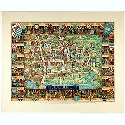
Oxford.
A comprehensive pictorial overview of Oxford’s rich history, especially in education.This image of Oxford is one of several pictorial maps Kerry Lee created to promote ...
Date: London, 1948
Selling price: ????
Please login to see price!
Sold in 2022
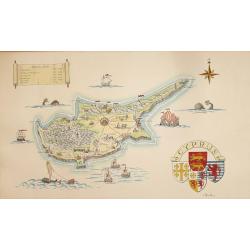
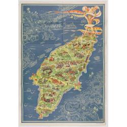
A Pictorial Map of Cyprus.
An attractive hand painted map of Cyprus a scroll cartouche has the Historical dates of the Islands occupation, the map centers on Nicosia. The sea has galleons, sea mons...
Date: ca. 1950
Selling price: ????
Please login to see price!
Sold in 2014