Browse Listings in Europe
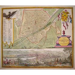
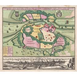
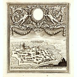
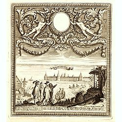
Ichonographia urbis...Florentina
A beautifully engraved, decorative plan of Florence with exceptional detail. A large coat-of-arms graces the top right hand corner of the plate. In the left section is a ...
Date: Nuremberg, (dated 1731) 1760
Selling price: ????
Please login to see price!
Sold in 2009
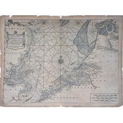
A Correct Chart of the Sea Coasts of England, Flanders and Holland showing the Sands, Shoals, Rocks and Dangers, The Bays and Harbours, Roads, Buoys, Beasons and Seamarks on the said Coasts.
A fine nautical chart of the coasts of Belgium, Holland, and Southern England by Mount and Page. The Mount and Page publishers firm of London was founded in 1701 by Richa...
Date: London, c.1760
Selling price: ????
Please login to see price!
Sold in 2010
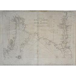
A Chart of the Bay of Galloway and River Shannon. . .
A fine nautical chart of the coastline along the Galway Bay of western Ireland by Mount and Page. The Mount and Page publishers firm of London was founded in 1701 by Rich...
Date: London, c.1760
Selling price: ????
Please login to see price!
Sold in 2010
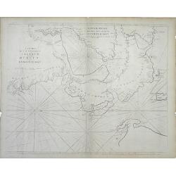
A Chart of the Seacoasts of Ireland from Dublin to London-Derry. . .
A fine nautical chart of the coastline along the northeast coast of Ireland, showing city of Dublin, by Mount and Page. The Mount and Page publishers firm of London was f...
Date: London, c.1760
Selling price: ????
Please login to see price!
Sold in 2010
Cataloniae Principatus et Ruscinonis ae Cerretaniae Comitatuum exactissima Delineatio, Cura et Studio. . .
Beautifully colored map of the Catalonia region of northeastern Spain by Tobias Conrad Lotter. The cities of Barcelona, Tortosa, Tarragona are depicted along the Mediterr...
Date: Augsburg, c.1760
Selling price: ????
Please login to see price!
Sold in 2010
Novissima Regnorum Portugalliae et Algarbiae descriptio.
Map of Portugal. Fine title and scale cartouche. With privilege of the State of Holland. The edition published by Covens and Mortier. Now with their address added.The Ams...
Date: Amsterdam, ca. 1760
Selling price: ????
Please login to see price!
Sold in 2010

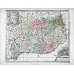
Circuli Austriaci pars Septentrionalis in qua Archiducatus. . .
Decorative and detailed map of Austria, here in a second state with the address of Jean Covens and Cornelis Mortier.The Amsterdam publishing firm of Covens and Mortier (1...
Date: Amsterdam, c. 1760
Selling price: ????
Please login to see price!
Sold in 2011
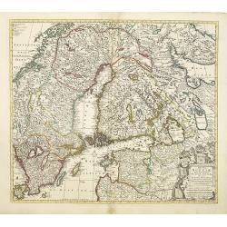
Regni Sueciae.
Attractive and detailed map of Scandinavia, including part of Russia, here in a second state with the address of Jean Covens and Cornelis Mortier.The Amsterdam publishing...
Date: Amsterdam, 1760
Selling price: ????
Please login to see price!
Sold in 2011
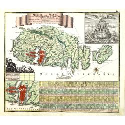
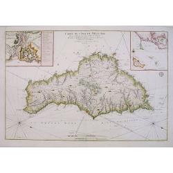
Melite vulgo Malta cum vicinis Goza..
Highly decorative map of Malta and the island of Gozo with figurative cartouche, title banner, inset view of a Maltese ship seen from the stern, inset plan of the city an...
Date: Augsbourg, 1760
Selling price: ????
Please login to see price!
Sold in 2010
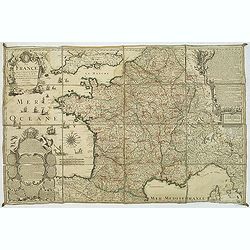
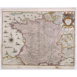
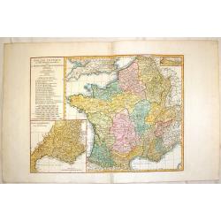
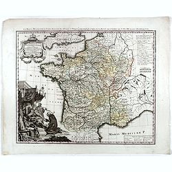
La France. Dressée suivant les nouvelles observation de Mrs De l'Academie Royale des Sciences Par Charles Inselin geografe et graveur.
A large and detailed map of France, decorated with a large title cartouche, and two others around engraved text descriptions of France and its provinces. Originally issue...
Date: Paris, 1760
Selling price: ????
Please login to see price!
Sold in 2011
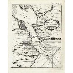
Plan du port de Lisbonne.
Highly detailed chart of the bay of Lisbon by the famous French geographer Nicolas Bellin. Shows the area with numerous forts, towns, and important landmarks along the co...
Date: Paris, ca. 1760
Selling price: ????
Please login to see price!
Sold in 2012
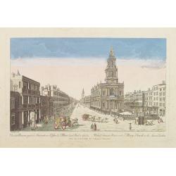
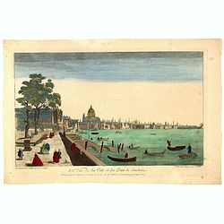
Vue de la Maison royale de Somerset avec l'Eglise de Ste. Marie dans le Strand a Londres. . .
So-called optical print illustrating the Somerset House with St. Mary's Church in the Strand London as indicated in the title. In the eighteenth and nineteenth centuries ...
Date: Paris, 1760
Selling price: ????
Please login to see price!
Sold in 2019
Carte Generale de Costes D'Irlande, et des Costes Occidentales D'Angleterre avec une Partie de celles D'Ecosse.
Very large engraved sea chart, with inset view of the River Dee at Chester. The chart showing the whole of Ireland and the Westcoast of England from Cornwall to Cuningham...
Date: Paris, 1760
Selling price: ????
Please login to see price!
Sold in 2011
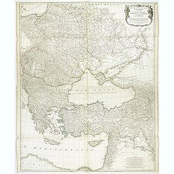
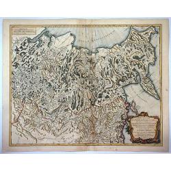
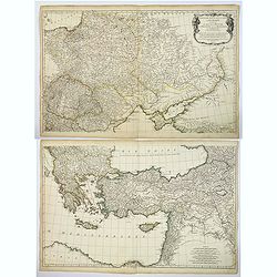
Troisieme partie de la carte d'Europe, contenant le midi de la Russie, la Pologne, et la Hongrie, la Turquie y compris celle d'Asie presqu'entiere. . .
Wall map sized map of Russia, Crimea, Turkey, Cyprus and Holey Land. Centered on the Black Sea. Prepared by Jean Baptiste Bourguignon d'Anville (1697-1782). Ornamental ca...
Date: Paris, 1760
Selling price: ????
Please login to see price!
Sold in 2011

Belem (left) and Portugais (right)
A pair of well defined and decorative 18th century prints. One depicts Mosteiro dos Jeronimos in the Belem section of Lisbon and the other an affluent couple in typical l...
Date: Paris, ca. 1760
Selling price: ????
Please login to see price!
Sold in 2011
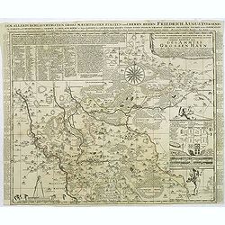
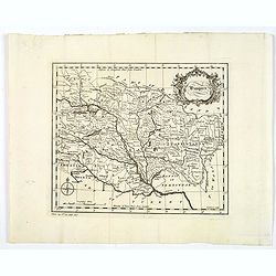
Accurate Geographische delineation. . . Des Ammtes grossen Hayn. . .
Very detailed map prepared by Adam Frederic Zürner (1680-1742). Surrounded with legends and decorated in the lower right corner with a plan of a royal campement. The tow...
Date: Amsterdam, 1760
Selling price: ????
Please login to see price!
Sold in 2016
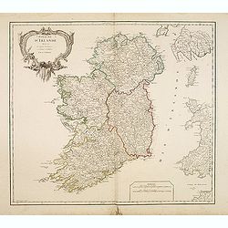
Royaume d'Irlande divisé en ses quatre Provinces.
Fine map of Ireland, engraved by the master Delahaye. Fine title cartouche. With ereased date.
Date: Paris, ca.1760
Selling price: ????
Please login to see price!
Sold in 2012
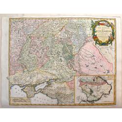
Partie Meridonale de la Russie Europeeennee
Important map of the southern part of Russia and the Ukraine. It has an inset of "Development de la Nouvelle Servie". Decorated with Rococo-style title cartouch...
Date: Paris, ca 1760
Selling price: ????
Please login to see price!
Sold in 2014
Coppenhagen die Konigl ...
A colored birds-eye view of Copenhagen. At bottom an uncolored panoramic view (100x570mm) with a legend, referring to all important buildings. A most decorative item, pub...
Date: Augsburg, 1760
Selling price: ????
Please login to see price!
Sold in 2013
Gallia Antiqua ex Aevi Romani Monumentis Eruta.
A fine copper engraved map of France and Belgium in ancient times. The title section includes a list of regions by Roman numeral to make them easier to find. The detailed...
Date: Paris, 1760
Selling price: ????
Please login to see price!
Sold in 2015
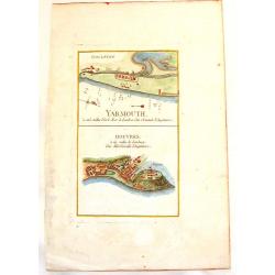
Yarmouth & Douvres.
An interesting copper engraved map showing the ports of Yarmouth and Dover in England. Louis Charles Desnos (1725-1805) was a geographer, bookseller and engineer, and ma...
Date: Paris, 1760
Selling price: ????
Please login to see price!
Sold in 2013
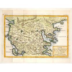
Carte de la Macedoine, de la Thessalie et de L'Epire.
Interesting copper engraved map of the Balkan region including what is currently Macedonia, Albania and northern Greece. Block style title cartouche. Jacques Nicolas Bel...
Date: Paris, 1760
Selling price: ????
Please login to see price!
Sold in 2013
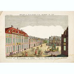
Vue du Marché aux Cheveaux a Stettin.
Rare so-called optical print illustrating the Horse market of Stettin in Poland.
Date: Augsburg, 1760
Selling price: ????
Please login to see price!
Sold in 2016
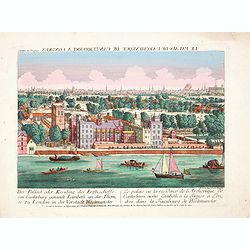
Der Pallast oder Residenz des Erzbischoffs von Canterbury ganandt Lambeth, an der Themse zu London. . .
Rare so-called optical print illustrating Lambeth Palace, the official London residence of the Archbishop of Canterbury, with a detailed view of London in the Background ...
Date: Augsburg, 1760
Selling price: ????
Please login to see price!
Sold in 2017

Der innere Prospect in der St. Peters Kirche in Rome. . .
Rare so-called optical print illustrating the interior of St. Paul in the Vatican. Engraved by Jean Benoit Winckler.The Academie Imperiale was a well-known publisher of o...
Date: Augsburg, 1760
Selling price: ????
Please login to see price!
Sold in 2014
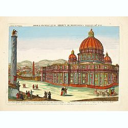
Die prachtige Sr. Peters Kirche im Vatican zu Rom. . . - Vuë de l'Eglise Cathetrade de St. Pierre au le Vatican a Rome.
Rare so-called optical print illustrating the St. Peter's Basilica in the Vatican. Engraved by Jean Benoit Winckler after Joseph Vasi.The Academie Imperiale was a well-kn...
Date: Augsburg, 1760
Selling price: ????
Please login to see price!
Sold in 2017
(Paide) Wittenstein in Lieffland / Wittenstein in Lieffland Oder Weissenstein kleine Stadt nebst eine Starken Schloss in der Lieflandische Provinz Estland. . .
Rare bird's eye view of Paide in Estonia by George Christian Kilian. The upper part of the engraving has very nice baroque decoration with an empty shield.Georg Christian...
Date: Augsburg, 1760
Selling price: ????
Please login to see price!
Sold in 2014
Noteburg. (Schüsselburg) / Ist eine hauptsächliche Festung an dem See Ladoga, wo der Fluss Nieva hinein fallt. . .
Rare bird's eye view of Schlüsselburg, east of St. Petersburg by George Christian Kilian. The upper part of the engraving has very nice baroque decoration with an empty ...
Date: Augsburg, 1760
Selling price: ????
Please login to see price!
Sold in 2014
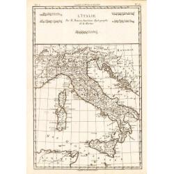
L'Italie.
Rigobert Bonne (1727-1795), French cartographer. His maps are found in a.o. Atlas Moderne (1762), Raynal's Histoire Philos. du Commerce des Indes (1774) and Atlas Encyclo...
Date: Amsterdam, c. 1760
Selling price: ????
Please login to see price!
Sold in 2018
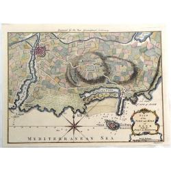
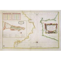
Plan of the Town and Mole of Agde with the Fort de Brescou.
Fine copper engraved map of Agde near the towns of Marseillan and Bessan, on the coastline of southern France in the Gulf of Lion. By John Hinton engraved for the "N...
Date: London, 1760
Selling price: ????
Please login to see price!
Sold in 2019
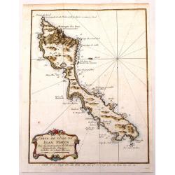
Carte de L'Isle de Jean Mayen.
Fine little copper engraved, hand colored map of the Island of Jean Mayen, off the coast of Norway. It was by Bellin. Features a decorative title cartouche.
Date: Paris, 1760
Selling price: ????
Please login to see price!
Sold in 2016
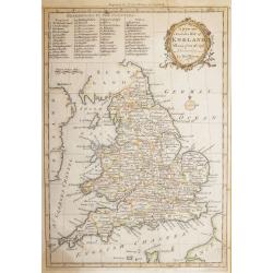
A new and Accurate Map of ENGLAND Drawn from the best Authorities by Thomas Bowen.
A detailed map of England and Wales engraved for Cowley’s History of England 1760 edition. The title is in a very ornate cartouche a list of references to the Counties ...
Date: London 1760
Selling price: ????
Please login to see price!
Sold in 2016
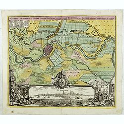
Prospect und Grundris der Keiserl. Freyen Reichs und Anse Stadt Bremen . . .
Decorative town plan of Bremen with surrounding area. In lower part a fine panoramic view.
Date: Nuremberg , ca. 1760
Selling price: ????
Please login to see price!
Sold in 2016

Vue d'Optique Representant: La Vue de la Grande Allee du Jardin de Vauxhall Prise de l'entrée
Optical print illustrating a perspective view of Vauxhall Garden in London. (No. 24e) It was produced at Chez Daumont in Paris in 1760.Vue d'Optique, is a special type of...
Date: Paris, 1760
Selling price: ????
Please login to see price!
Sold in 2015
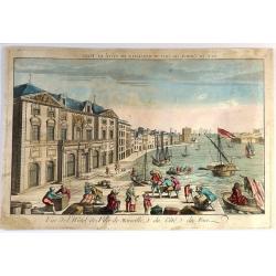
Vue de l'Hôtel de Ville de Marseille du Côté du Port.
Striking copper engraved optical print illustrating a perspective view of the City Hall of Marseille, France, taken from the harbour.In the eighteenth and nineteenth cent...
Date: Paris, 1760
Selling price: ????
Please login to see price!
Sold in 2018
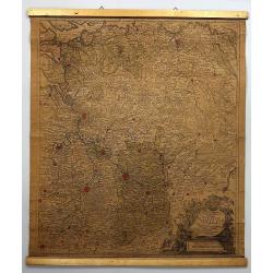
Circuli Super. Saxoniae Pars Meridionalis . . .
Map of a large part of Germany and a part of the Czech Republic. The map includes the cities: Prague, Berlin, Frankfurt, Magdeburg, Brandenburg, Halle, Leipzig and Dresde...
Date: Augsburg, 1760
Selling price: ????
Please login to see price!
Sold in 2016

Dvcatvvm Livoniae et Cvrlandiae cum vicinis. . .
A very attractive of Livonia, Estonia, Curlandia and the Baltic coast.
Date: Nuremberg, 1760
Selling price: ????
Please login to see price!
Sold in 2016
83e Vue de la Ville et du Pont de Londres.
So-called optical print of London with River Theems. Basset was a well-known publisher of optical prints, established in rue S.Jacques in Paris. In the eighteenth and nin...
Date: Paris, 1760
Selling price: ????
Please login to see price!
Sold in 2016

Het Admiraliteits of Prinsen - Hof
The Admiralty or courtyard of the Princes, the former Town Hall, seen at right with the main entrance from the side against the Princes Lane. Original copper engraving fr...
Date: Amsterdam, 1760
Selling price: ????
Please login to see price!
Sold in 2018

Elisabeth I. Russorum Imperatrixnata 1709 d. 20 Dec.
Portrait of Elizaveta Petrovna, Empress of Russia three-quarters length, body turned slightly to left but looking at the viewer, set in a decorative border.In lower part ...
Date: Augsburg, Paris, ca. 1760
Selling price: ????
Please login to see price!
Sold in 2016

L'Exterieur de la Chapelle du Chateau de Versailles, du Cote de la Cour.
So-called optical print of The Exterior of the Chapel of the Chateau de Versailles, the Court of Approval (lOUIS XIV'S CHAPEL) by Basset.Basset was a well-known publisher...
Date: Paris , 1760
Selling price: ????
Please login to see price!
Sold in 2016
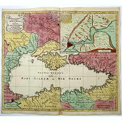
Nova Mappa Maris Nigri et Freti Constantino Politani. . .
Decorative and uncommon map the Black Sea region.
Date: Augsburg, ca. 1760
Selling price: ????
Please login to see price!
Sold in 2018
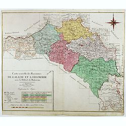
Carte nouvelle des Royaumes de Galizie et Lodomerie avec le district de Bukowine.
Uncommon map showing parts of present-day Poland and Ukraine. Including the Kingdom of Galicia and Lodomeria, which was a crown land of the Habsburg Monarchy that was acq...
Date: Augsburg, ca. 1760
Selling price: ????
Please login to see price!
Sold in 2016
La France bénédictine, ou carte générale des abbayes . . .
This uncommon map is showing France with its provinces according to the Order of Saint Benedict. Larghe title cartouche, lower left, showing the King of France, who is si...
Date: Nuremberg, 1760
Selling price: ????
Please login to see price!
Sold in 2019
Partie orientale de L'Empire de Russie en Asie ...
A detailed map of eastern Russia that was published in the "Atlas Universel". The map extends from Kamchatka to Obskaya Guba and included Lake Baikal. Detail ex...
Date: Paris , 1760
Selling price: ????
Please login to see price!
Sold in 2017
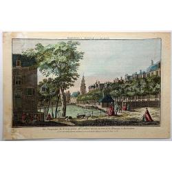
Vue Perspective du Koningsplein au Reguliers Touring, ou Tour de la Monnoye, a Amsterdam.
A pleasing vue perspective featuring a river in Amsterdam. Published by Chez Maillet in Paris in 1760. After an model by Jan de Beijer (1703-1780).In the eighteenth and ...
Date: Paris, 1760
Selling price: ????
Please login to see price!
Sold in 2018
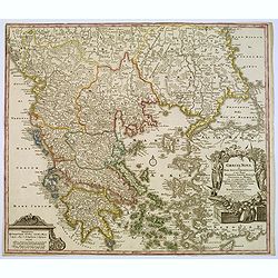
Graecia Nova et Mare Aegeum l'Archipelagus .. Morea..
An attractive map of Greece, with a beautiful title cartouche, and an explanation table and mileage scales filling the lower corners of the map.T.C. Lotter married M. Seu...
Date: Augsburg, 1760
Selling price: ????
Please login to see price!
Sold in 2017
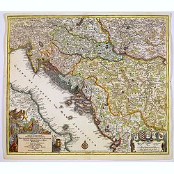
Nova et accurata.. Dalmatiae, Croatiae, Sclovoniae, Bosniae. . .
A finely engraved and large detailed map including the western part of the river Donau. Two decorative cartouches adorn the lower corners of the map. One with coats of ar...
Date: Augsburg, 1760
Selling price: ????
Please login to see price!
Sold in 2017
Troisieme partie de la Carte d'Europe conenant ..Russie, Pologne et la Hongrie, la Turquie. . .
A large 2 sheet map, by French cartographer d'Anville, measuring 1030 x 1620 mm when joined together, showing most of Eastern Europe, parts western Russia and parts of th...
Date: Paris, ca. 1760
Selling price: ????
Please login to see price!
Sold in 2017
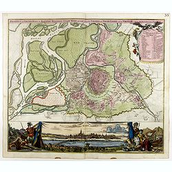
Prospect und Grund-riss der Kayserl. Residenz-stradt wien mit negst aligender . . .
Decorative town plan of Vienna with surrounding area. In lower part a fine panoramic view with Danube in the foreground.
Date: Nuremberg , ca. 1760
Selling price: ????
Please login to see price!
Sold in 2020
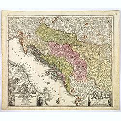
Nova et accurata.. Dalmatiae, Croatiae, Sclovoniae, Bosniae. . .
A finely engraved, large detailed map that includes the western part of the river Donau. Two decorative cartouches adorn the lower corners of the map. One of these shows ...
Date: Augsburg, 1760
Selling price: ????
Please login to see price!
Sold in 2018
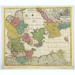
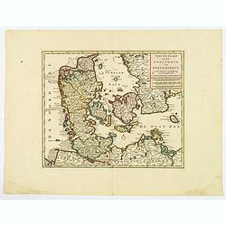
Daniae Regnum cum Ducatu Holsatiae et Slesvici. . .
An attractive map of Denmark by the German cartographer Tobias Lotter. The map also incorporates parts of northern Germany, including Schleswig Holstein, and the southern...
Date: Augsburg, 1760
Selling price: ????
Please login to see price!
Sold in 2020
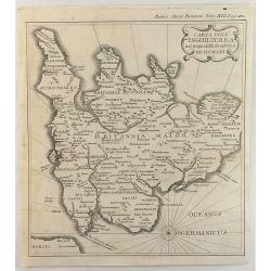
Carta Dell' Inghilterra nel Tempo della Decandenz a de Romani.
A detailed, fine and unusual ca 1760 Charles Rollin copper engraved historical map of England & Wales at the time of the Roman Domination. The map provides good topog...
Date: Paris, 1760
Selling price: ????
Please login to see price!
Sold in 2019
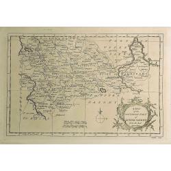
A Map of the Southern Part of Lower Saxony. . .
A magnificent copper engraved map of the southern part of Lower Saxony or Hanover, Germany engraved by George Rollos, and published by J. Coote in London in 1760. It fea...
Date: London, 1760
Selling price: ????
Please login to see price!
Sold in 2019
Nieuwe kaart van het Koninkryk van Deenemarken
A detailed and well engraved map of the kingdom of Denmark by one of the most important publishers in 18th century Amsterdam. With a box title and mileage scales below. I...
Date: Amsterdam, 1760
Selling price: ????
Please login to see price!
Sold in 2021
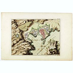
Plan of the town and harbour of Collioure.
Plan of the town and harbour of Collioure, a commune in the southern French department of Pyrénées-Orientales. In upper right Plate LXIX. Thomas Jefferys (c. 1719 – 1...
Date: London, ca. 1760
Selling price: ????
Please login to see price!
Sold in 2023
Hungary.
A map of mid eighteenth century copperplate map of Hungary, with a decorative title cartouche. Bordered by Poland, Slavonia, Turkey, Moldova and Romania. Map is split int...
Date: London, ca 1760
Selling price: ????
Please login to see price!
Sold in 2020
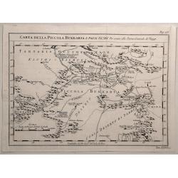
Carta Della Piccola Bukkaria e Paesi Vicini per Servire alla Storia Generale de Viaggi.
Interesting map of the Russian / Chinese border including Mongolia and the Gobi Desert. Jacques Nicolas Bellin (1703-1772) was one of the most important and proficient...
Date: Paris, 1760
Selling price: ????
Please login to see price!
Sold in 2020
![[Portrait of Jan Wagenaar with title page] Amsterdam in Zyne opkomst, aanwas, Geschiedenissen . . .](/uploads/cache/44990-250x250.jpg)
[Portrait of Jan Wagenaar with title page] Amsterdam in Zyne opkomst, aanwas, Geschiedenissen . . .
Portrait of the historian Jan Wagenaar, engraved by Jacob Houbraken, in 1766 after a painting by Jacobus Buys. Together with title page from "Amsterdam in zyne opkom...
Date: Amsterdam, 1760
Selling price: ????
Please login to see price!
Sold in 2019
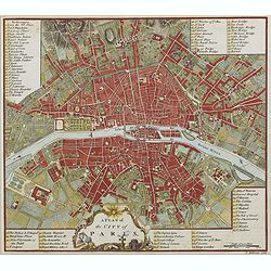
A plan of the city of Paris.
Uncommon plan of Paris with a very decorative title cartouche with globe, sun, etc. A numbered key (1-78) to most important buildings and streets in town. Engraved by J. ...
Date: London 1760
Selling price: ????
Please login to see price!
Sold in 2019
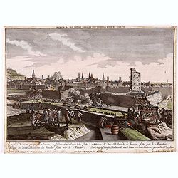
Attaque de deux bastions les breches faites par le mineur.
Optical view. Reversed title. Print of Barcelona’s siege in 1714. (From Hyacinthe Rigaud). Ink annotations in the margins.
Date: Augsburg, ca. 1760
Selling price: ????
Please login to see price!
Sold in 2020
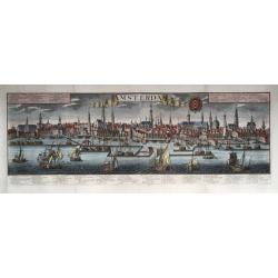
Amsterdam.
Very large size general panoramic view of the city from the water ('het IJ') with the harbour up front. With key 1-30 below the view, in Dutch (bottom left), Latin (botto...
Date: Augsburg, 1740-1760
Selling price: ????
Please login to see price!
Sold in 2020
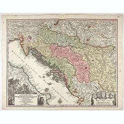
Nova et accurata.. Dalmatiae, Croatiae, Sclovoniae, Bosniae. . .
A finely engraved and large detailed map including the western part of the river Donau. Two decorative cartouches adorn the lower corners of the map. One with coats of ar...
Date: Augsburg, 1760
Selling price: ????
Please login to see price!
Sold in 2023
![[Lot of 6 maps of Italy]](/uploads/cache/20941-(1)-250x250.jpg)
[Lot of 6 maps of Italy]
Claude Buy de Mornas (dl 1783), géographe du roi (1764). Atlas Méthodique et Elémentaire de Géographie et d' Histoire, 1761, Atlas Historique et Géographique, 1762.�...
Date: c. 1760
Selling price: ????
Please login to see price!
Sold in 2022
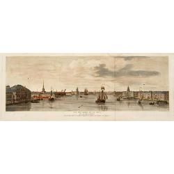
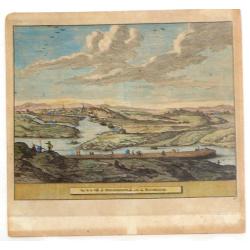
Vue des bords de la Neva..
Sight of the edges of the river Neva between the Winter palace and the imperial Academy of sciences at Saint-Petersburg.
Date: Saint-Petersbourg 1761
Selling price: ????
Please login to see price!
Sold
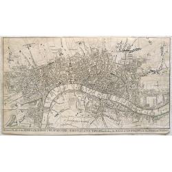
A correct plan of the cities of London & Westminster & Borough of Southwark including the bills o mortality with the additional buildings
This map of London was published as supplement to Volume 30 of the 'London Magazine' in 1761. Attributed to John Rocque, the map's title features in a panel below the pla...
Date: London, 1761
Selling price: ????
Please login to see price!
Sold in 2013
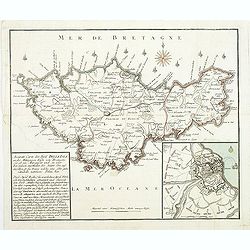
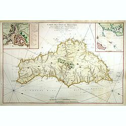
Carte De L'Isle De Belle-Isle..
Large-scale sea of Belle-Ile, in upper right corner inset of the French coast with Belle-Ile, îles de Quiberon with the bay of Morbihan. With rhumb lines.Published by t...
Date: Paris, 1761
Selling price: ????
Please login to see price!
Sold
Carte du Detroit de Gibraltar Dressée au Depost des Cartes et Plans de la Marine pour le service des Vaisseaux du Roy par Ordre de M. le Duc de Choiseul Ministre de la Guerre et de la Marine. . . N° 35
A very detailed chart prepared by J.N. Bellin of the Straits of Gibraltar locating harbors and bays and coastal soundings. Decorative title cartouche. Depicts Cape Trafal...
Date: Paris, 1761
Selling price: ????
Please login to see price!
Sold in 2009
Accurate Carte des insul BelleIsle an der Mittägien Küste von Bretagne. . .
Map of Belle Isle. In the lower left corner a descriptive text with a chronology of the siege and occupation of the island "Accurate Carte der INSUL BELLE ISLE [Bell...
Date: Nurnberg, 1761
Selling price: ????
Please login to see price!
Sold
Vue de la Ville de Newaberdene du cote de Blockhause.
Striking hand colored, copper engraved view of Aberdene, Scotland. Pieter van der Aa (1659 - 1733) was a Dutch publisher, best known for preparing maps and atlases. He ...
Date: Amsterdam, 1761
Selling price: ????
Please login to see price!
Sold in 2014
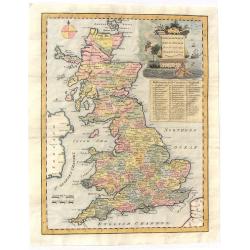
An Accurate Map of Great Britain from the latest & best Observations.
Striking and highly detailed s copper engraved map of the United Kingdom. The map shows cities, towns, rivers, roads, lakes, islands and regional divisions. A large deco...
Date: London, 1761
Selling price: ????
Please login to see price!
Sold in 2018
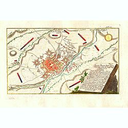
Accurater Plan der Stadt u: Vestung Schweidnitz. samt der Köngl. Preusse Attaque A: 1758. . .
Detailed colored map shows the Battle of Swidnica in Poland - during the Seven Years' Warm in 1758. The key on the right-hand side explains the events and the position of...
Date: Nuremberg: Raspische Handlung, 1761
Selling price: ????
Please login to see price!
Sold in 2016
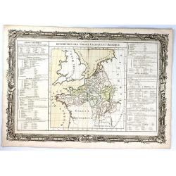
Description des Gaules Celtique et Belgique
A fine map of Gallic France and Belgium by Claude Buy de Mornas. It is from “Atlas Méthodique et Elémentaire de Géographie et l’ Histoire”, published in 1761.The...
Date: Paris, 1761
Selling price: ????
Please login to see price!
Sold in 2017
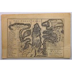
An Exact Plan of the Capital City and Port of Malta, with its Suburbs and Dependencies .
A detailed plan of Valletta, dedicated to the 'Grand Officers of the Order of St. John'.The map of Valletta is accompanied with a lettered and numbered key, identifying b...
Date: London, 1761
Selling price: ????
Please login to see price!
Sold in 2017
Nova Tabula Geographica exhibens Ducatum Brabantiae Cum Pertinentiis et adjacentibus Regionibus . . .
A detailed regional map of Brabant, centered on Antwerp, Brusells, Mechlen and Louvain in Belgium, and extending north to Breda and east to Maastricht. Map is by Conrad L...
Date: Augsburg, 1761
Selling price: ????
Please login to see price!
Sold in 2019
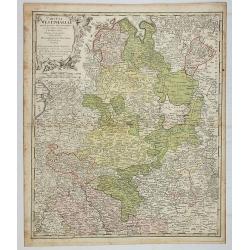
Ducatus Iuliacensis, Cliviensis et Montensis, ut et Principatus Meursiani et Comitatus Zutphaniensis Novissima et Accuratissima Delineatio.
Map of North Rhine-Westphalia (Germany) featuring the Duchies of Iuliacensis, Cliviensis and Berg. The map has a very large cartouche featuring five crests with crowns, a...
Date: Augsburg, 1761
Selling price: ????
Please login to see price!
Sold in 2019
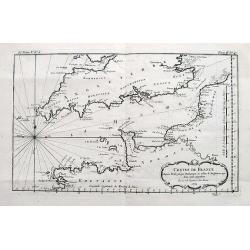
Costes de France depuis Brest jusqu'a Dunkerque...
An interesting chart of the Channel with the English and French coasts. Extends from Bristol to Cornwall, all the way to London and Kent in England; and from Brest to Par...
Date: Paris, 1761
Selling price: ????
Please login to see price!
Sold in 2017
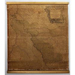
Circuli Westphaliae Quoad Partem Septentrionalem. . .
A fine detailed regional map of Westphalia in Germany, extending from Bremen and Hamburg in the north to Cologne, Bonn, Dusseldorf, Aix, Wyck and Luttich in the south. Ar...
Date: Nuremberg, 1761
Selling price: ????
Please login to see price!
Sold in 2019
Carte De L'Isle De Belle-Isle. . .
Large-scale sea chart of Belle-Ile, in upper right corner inset of the French coast with Belle-Ile, îles de Quiberon with the bay of Morbihan. With rhumb lines.Published...
Date: Paris, 1761
Selling price: ????
Please login to see price!
Sold in 2018
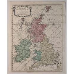
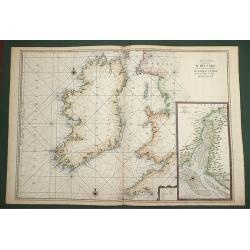
An Accurate Map of England, Scotland and Ireland. . .
A fine hand-colored map of England, Scotland & Ireland by Seale, it was published in the “UNIVERSAL MAGAZINE” BY Hinton. colored by region, it features a decorati...
Date: London, 1761
Selling price: ????
Please login to see price!
Sold in 2020