Browse Listings in Europe
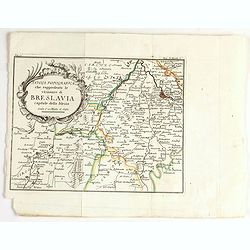
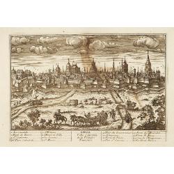
Tavola topografica che rappresenta le vicinanze di breslavia.
Detailed map showing the area west of Wroclaw, large title cartouche in upper left corner.
Date: Italy, ca. 1757
Selling price: ????
Please login to see price!
Sold in 2020
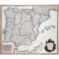
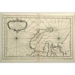
LOS REYNOS DE ESPANA Y PORTUGAL...
A nice example of Gendron's map of the Iberian Peninsula. As most 18th Century maps published in Spain, which are based upon non-Spanish sources, are based upon French so...
Date: Madrid, 1757
Selling price: ????
Please login to see price!
Sold in 2021
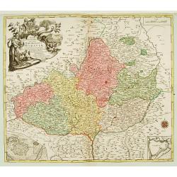
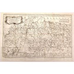
MAPPA GEOGRAPHICA SPECIALIS MARCHIONATUS MORAVIAE IN SEX CIRCULOS DIVISAE?
Map depicting the South/East part of Czech republic, showing Brno and Olomouc and two insets of these cities lower corners.
Date: Augsburg, 1758
Selling price: ????
Please login to see price!
Sold
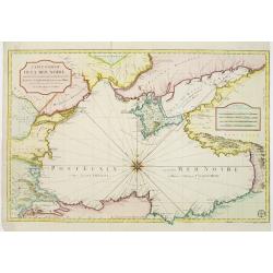
Carte réduite de la Mer Noire, dressée pour le service des vaisseaux du Roy. Par ordre de M. de Boynes, secretaire d'Etat..
Large scale chart of the Black Sea, with hand-coloringBellin (1703-1772) began working for the newly established Dépôt des Cartes et Plans de la Mari...
Date: Paris 1758
Selling price: ????
Please login to see price!
Sold
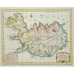
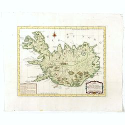
Carte de L'Islande . . .
A good engraved map of the island Iceland with rococo title cartouche lower right. From l'Histoire générale des voyages.
Date: Paris, 1758
Selling price: ????
Please login to see price!
Sold in 2011
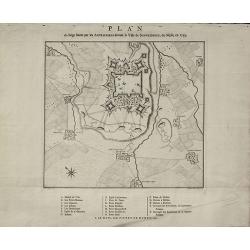
Plan du Siège formé par les Autrichiens devant la Ville de Schweidnitz, en Silesie, en 1757
Rare Military Plan of Swidnica in Silesia during the Seven Years' War by Pieter de Hondt. Showing the siege of Swidnica in 1757. After L. W. F. Von Oebschelwitz, engraved...
Date: The Hague, 1758
Selling price: ????
Please login to see price!
Sold in 2015
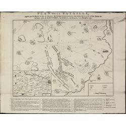
Plan de la Bataille, gagnée par Sa Majesté le Roi de Prusse, sur l'Armée Autrichienne, aux ordres de S.A.R de Duc Charles de Lorraine, près de Leuthen, ou Lissa, en Silesie, le 5. Decembre 1757
A rare military plan of Leuthen in Silesia during the Seven Years' War by Pieter de Hondt. Showing the Battle of Leuthen on 5 December 1757 during the Seven Years War. Af...
Date: The Hague, 1758
Selling price: ????
Please login to see price!
Sold in 2015
Detailed plan of Krefeld. . .
Detailed plan of Krefeld showing the battle of 23 June 1758 between Duke Ferdinand van Brunswyk and the French army under command of the Duke of Clermond. With extensive ...
Date: Amsterdam, 1758
Selling price: ????
Please login to see price!
Sold in 2019
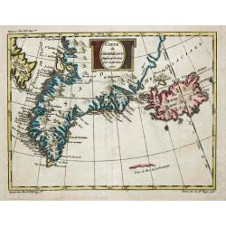
Partie de la Mer Glaciale Contenant La Nouvelle Zemble.
Detailed copper engraved map of Russia's Nova Zembla and a portion of the Northwest Passage. Produced by Bellin for "L'Histoire Generale des Voyages". Large bal...
Date: Paris, 1758
Selling price: ????
Please login to see price!
Sold in 2015
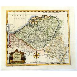
Austrian and French Netherlands.
Interesting copper engraved map featuring the Flanders and Brabant regions bordered by Luxemburg and Artois. Featuring a decorative Rococo title cartouche and a prominent...
Date: London, 1758
Selling price: ????
Please login to see price!
Sold in 2013
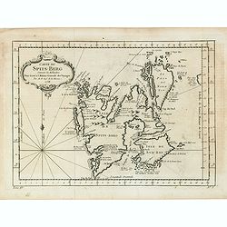
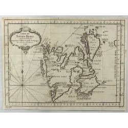
Carte Du Spits-Berg Suivant les Hollandois . . . 1758
A decorative map of Spitsbergen (Svalbard) with the adjacent islands of Franz Josef Land and Jan Mayan. The geographical features are typical with somewhat exaggerated ba...
Date: Paris, 1758
Selling price: ????
Please login to see price!
Sold in 2021
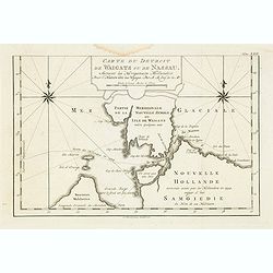
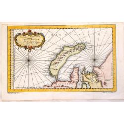
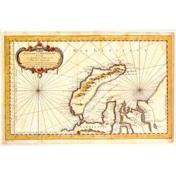
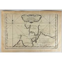
Carte du Detroit de Waigats ou de Nassau.
Showing the Dutch voyage of 1594 which proved Nova Zemlya was an island separated from the continent by the "le Waigats Detroit". Several sounding shown and one...
Date: Paris, 1758
Selling price: ????
Please login to see price!
Sold in 2020
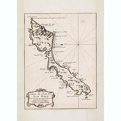
Carte de L'Isle de Jean Mayen. . .
Charming map of Jan Mayen Island, a volcanic island in the Arctic Ocean and part of the Kingdom of Norway. Several sounding shown.From Prevost's l'Histoire générale des...
Date: Paris, 1758
Selling price: ????
Please login to see price!
Sold in 2016
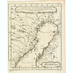
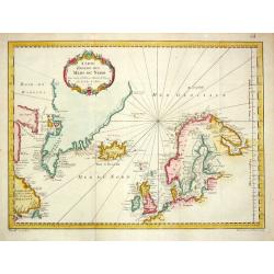
Suite du Golphe de Bothnie. . .
Charming map of the northernmost portion of the Golf of Bothnia, which separates Sweden and Finland. Several sounding shown.From Prevost's l'Histoire générale des voyag...
Date: Paris, 1758
Selling price: ????
Please login to see price!
Sold in 2018
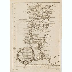
Carte des environs de Tornea. . .
Charming map of the area around Tornio in Finland. Several sounding shown.From Prevost's l'Histoire générale des voyages , the map prepared by J.N. Bellin. Jacques Nico...
Date: Paris, 1758
Selling price: ????
Please login to see price!
Sold in 2017
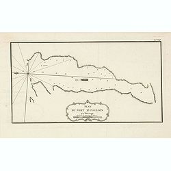
Plan du port d'Ingeson en Norvege.
Charming map of the Porsangerfjorden in northern Norway. The 123-kilometre long fjord is Norway's fourth longest fjord. It is located in the municipalities of Nordkapp an...
Date: Paris, 1758
Selling price: ????
Please login to see price!
Sold in 2021
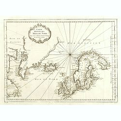
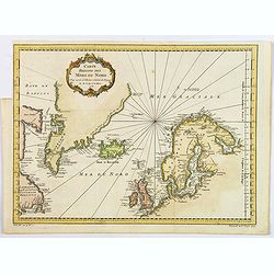
Carte Réduite des Mers du Nord Pour servir a l'Histoire Generale des Voyages.
Detailed sea chart of the coasts of Scandinavia, the British Isles, Iceland (with volcano Hekla), Greenland and contiguous parts of Canada.Prepared by Nicholas Bellin for...
Date: 1758
Selling price: ????
Please login to see price!
Sold in 2014
Carte de la Siberie et des Pays Voisins.
An interesting detailed map of North-Western Siberia, extending from the White Sea and the Caspian Sea in the west to Irkuckoi Province.Prepared by Jacques Nicolas Bellin...
Date: Paris, 1758
Selling price: ????
Please login to see price!
Sold in 2015
Carte du Detroit de Waegats ou de Nassau.
Interesting map of Northern Russia featuring the south (warm) side of the island, Nouvelle Zemble, one of the coldest places on earth. By Nicholas Bellin in France in 175...
Date: Paris, 1758
Selling price: ????
Please login to see price!
Sold in 2015
Partie de la Mer Glaciale Contenant la Nouvelle Zemle.
Detailed map of Nova Zembla and part of the Northeast passage in Northwest Russia. Published in "L'HISTOIRE GENERALE DES VOYAGES" by Nicholas Bellin.
Date: Paris, 1758
Selling price: ????
Please login to see price!
Sold in 2017
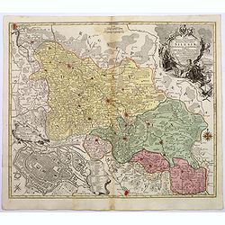
Nova Mappa Geographica Totius Ducatus Silesiae. . .
A striking map of Silesia by Lotter, published in the mid eighteenth century.The map covers central Europe in general, and parts of Poland in particular. Most of Silesia ...
Date: Augsberg, 1758
Selling price: ????
Please login to see price!
Sold in 2017
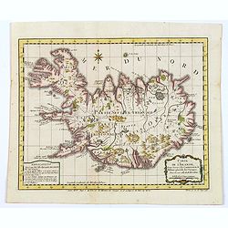
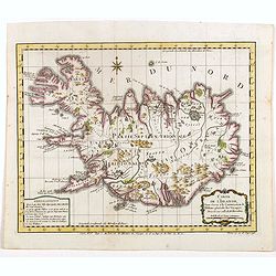
Carte de l'Islande pour servir á la continuation de l'histoire générale des voyages. Dressée sur celle de M. Horrebows.
A good engraved map of the island of Iceland, prepared by Bellin after M. Horrebows, with rococo title cartouche in lower right, explanation table bottom left. From l'His...
Date: Paris, 1758
Selling price: ????
Please login to see price!
Sold in 2017
Carte du Detroit de Waeigats ou de Nassau.
Detailed regional map of the Strait of Waeigats in the Arctic Sea. Includes a decorative title cartouche. One of the maps produced by Bellin for Prevost d'Exiles' influen...
Date: Paris, 1758
Selling price: ????
Please login to see price!
Sold in 2017
Partie de la Mer Glaciale Contenant la Nouvelle Zemble et le Pais des Samoiedes.
An attractive copper engraved map of Nova Zembla, a frigid island north of Russia. It has a decorative rococo title cartouche. Jacques Nicolas Bellin (1703–1772) was a ...
Date: Paris, 1758
Selling price: ????
Please login to see price!
Sold in 2018
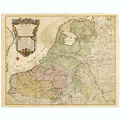
Carte des XVII provinces des Pays-Bas . . .
Fine two-sheet wall-map size map of present-day The Netherlands and Belgium with a decorative armorial cartouche and small scale of miles.Alexis-Hubert Jaillot (1632-1712...
Date: Paris, 1758
Selling price: ????
Please login to see price!
Sold in 2018
Carte de l'Islande pour servir á la continuation de l'histoire générale des voyages. Dressée sur celle de M. Horrebows.
A good engraved map of the island of Iceland, prepared by Bellin after M. Horrebows, with rococo title cartouche in lower right, explanation table bottom left. From l'His...
Date: Paris, 1758
Selling price: ????
Please login to see price!
Sold in 2019
Carte Reduite des Mers du Nord.
A nice detailed sea chart of the coasts of Scandinavia, the British Isles, Iceland, Greenland and contiguous parts of Canada. Includes a decorative title cartouche. One o...
Date: Paris, 1758
Selling price: ????
Please login to see price!
Sold in 2021
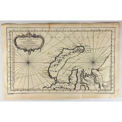
Carte de Spits-Berg Suivant les Hollandois.
A detailed map of Spitsbergen with the adjacent islands; the largest permanently populated island of the Svalbard Archipeligo in Norway. It features a French style decor...
Date: Paris, 1758
Selling price: ????
Please login to see price!
Sold in 2018
Carte de l'Islande pour servir á la continuation de l'histoire générale des voyages. Dressée sur celle de M. Horrebows.
A good engraved map of the island of Iceland, prepared by Bellin after M. Horrebows, with rococo title cartouche in lower right, explanation table bottom left. From L'His...
Date: Paris, 1758
Selling price: ????
Please login to see price!
Sold in 2021
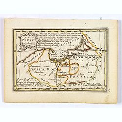
Prussia.
An attractive 18th century miniature map of Prussia which was drawn and engraved by John Gibson for the pocket atlas, Atlas Minimus Illustratus: Containing Fifty-Two Pock...
Date: London, 1758
Selling price: ????
Please login to see price!
Sold in 2021
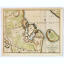
Plan of Stralsund, with the Trenches Lines & Batteries. . .
Stralsund is a Hanseatic town in the Pomeranian part of Mecklenburg-Vorpommern, in Germany. It is located at the Southern coast of the Strelasund, a sound of the Baltic S...
Date: London, 1758
Selling price: ????
Please login to see price!
Sold in 2021
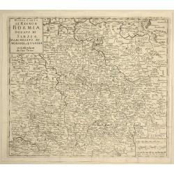
Nuova Carta del Regno di Boemia, Ducato di Slesia, Marchesato di Moravia e Lusazia.
Detailed map of the Southern part of Poland, Moravia and Bohemia, pubished in Italian edition of Thomas Salmon's "Modern History", published in Naples by Franc...
Date: Venice, 1758
Selling price: ????
Please login to see price!
Sold in 2021
Partie de la Mer Glaciale, Contenant La Nouvelle Zemble et le Pais des Samoiedes.
A detailed map of Nova Zembla and part of the Northeast Passage at the top of Russia. From Prevost’s L’Histoire General des Voyages. It features a rococo cartouche.Ja...
Date: Paris, 1758
Selling price: ????
Please login to see price!
Sold in 2019
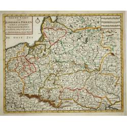
Nieuwe kaart van 't Koningkrijk Poolen.
Nice copper engraved map of the Kingdom of Poland excellently details topography, cities and villages. It is embellished with a simple compass rose. Engraved by J. Keyser...
Date: Amsterdam, 1759
Selling price: ????
Please login to see price!
Sold
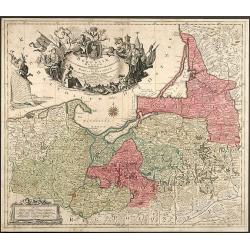
Borussiae Regnum complectens Circulos Sambiensem, Natangiensem et Hockerlandiae nec non Borussia Polonica Exhibens Palatinatus Culmiensem, Marienburgensem, Pomerelliae et Varmiae
Decorative copper engraved map of Poland by T. C. Lotter. Covering the area around Dantzig (Gdansk), Elbing (Elblag) and Königsberg (Krolewiec). The map has a highly dec...
Date: Augsburg, 1759
Selling price: ????
Please login to see price!
Sold in 2008
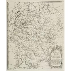
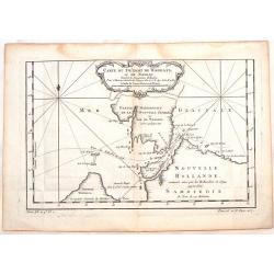
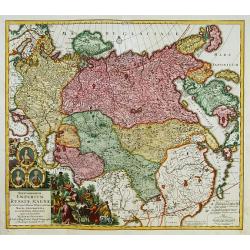
Partie de l'Empire de Russie comprise en Asie par le Sr. D'Anville. . .
Map of Russia.
Date: Paris, ca. 1759
Selling price: ????
Please login to see price!
Sold in 2009
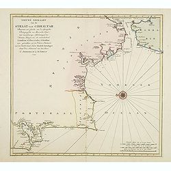
Nieuwe zeekaart van de Straat van Gibraltar..
Decorative map of Gibraltar and the coast of the Algarve (Portugal) till Lisbon. Including northern most tip of Morocco, including towns of Tangier, Ceuta and Tetuan.East...
Date: Amsterdam, 1759
Selling price: ????
Please login to see price!
Sold in 2017
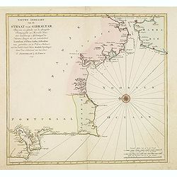
Nieuwe zeekaart van de Straat van Gibraltar. . .
Decorative map of Gibraltar and the coast of the Algarve (Portugal) till Lisbon. Including northern most tip of Morocco, including towns of Tangier, Ceuta and Tetuan.East...
Date: Amsterdam, 1759
Selling price: ????
Please login to see price!
Sold in 2013
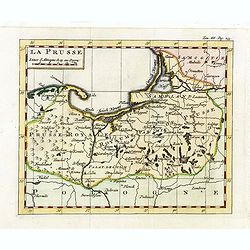
La Prusse.
Fine miniature map of Prussia, likely published by Claude Buffier. In upper right corner "Tom.III. Pag. 233.
Date: Paris, ca. 1759
Selling price: ????
Please login to see price!
Sold in 2015
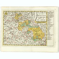
Landkort over det Hertugdom Schlesien udgiven af N : Jonge.
This scarce map of Silesia was published in a Danish atlas "Fra Holbergs Geographie" by Nikolay (Nicolai) Jonge (1727 – 1789) in Copenhagen in 1759.Including ...
Date: Copenhagen, 1759
Selling price: ????
Please login to see price!
Sold in 2016
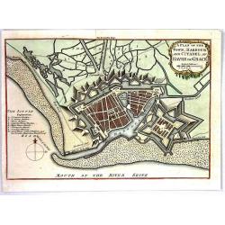
A Plan of the Town, Harbour and citadel of Havre de Grace
A handsome plan of the French port city of Havre de Grace that shows its many fortifications. A key at left locates churches, bastions, etc. Excellent detail of jetties, ...
Date: London, 1759
Selling price: ????
Please login to see price!
Sold in 2016
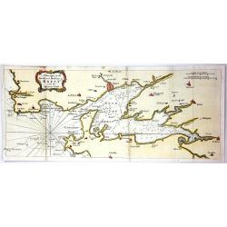
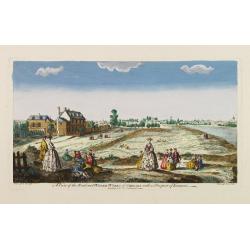
A Draught of the Road and Harbour of Brest with the Adjacent Coast
An interesting copper engraving map of France with rhumb lines and fleur-de-lys. Map extends from Le Counquet to Le Faou, detailing the coastline, anchorages and sounding...
Date: Paris, 1759
Selling price: ????
Please login to see price!
Sold in 2016
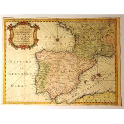
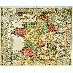
A New and Accurate Map of the Kingdoms of Spain, Portugal and Part of France, The Islands of Majorca, Minorca &c.
Produced for “Universal Magazine” by J. Hinton. It was engraved by Richard William Seale (1703-1762). The map features an attractive rococo cartouche and compass ros...
Date: London, ca. 1760
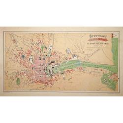
Stuttgart 1846 u. 1871.
A very detailed plan of Stuttgart. Showing the situation of 1846 and the expansion of 1871. Lithographed by H.A.Schurath and printed by "Dampfsnellpressendruck v.A G...
Date: Augsburg 1760
Selling price: ????
Please login to see price!
Sold
![Two maps and a print of Switzerland. [3 items].](/uploads/cache/14381-250x250.jpg)
Two maps and a print of Switzerland. [3 items].
Uncommon map 38x61cm) centered on Lake Lucerne, with the Alps in the back ground. Engraved by Charles Nicolas Dauphin de Beauvais (1730-1785)WITH: a map "Carte g&...
Date: Frankfurt 1623-78/ Paris 1760
Selling price: ????
Please login to see price!
Sold
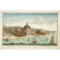
A view of the Palace of the King of Portugal at LISBONE.
One of the lesser-known publishers of optical prints, established in Paris.In the eighteenth and nineteenth centuries there were many popular speciality establishments in...
Date: Paris, ca. 1760
Selling price: ????
Please login to see price!
Sold in 2017
Lille.
"A very RARE panoramic view of the city of Lille, including a numbered legend in both lower corners. The plate is numbered in black pencil in upper right corner. Pub...
Date: Paris, 1760
Selling price: ????
Please login to see price!
Sold
Bourdeaux.
"A very RARE panoramic view of the city of Bordeaux, including a numbered legend in both lower corners. The plate is numbered in black pencil in upper right corner. ...
Date: Paris, 1760
Selling price: ????
Please login to see price!
Sold
Le Royaume de France et les conquetes de Louis le Grand.
Engraved by J.Christofle Steinberger. RARE and very decorative map of France surrounded with 20 insets of town plans : [1.] Philisbourg: [2.] Mons: [3.] Longwy: [4.] Homb...
Date: Augsburg 1760
Selling price: ????
Please login to see price!
Sold
Imperium Russiae Magnae..
With decorative title cartouche in lower left corner. Including the Asian part of Russia, China, Taiwan and part of Japan.
Date: Augsburg 1760
Selling price: ????
Please login to see price!
Sold

4e Vue d'Optique../..St Pierre de Rome.
So-called optical print of the interior of the Basilica Saint-Pierre de Rome.Daumont was a well-known publisher of optical prints, established in Paris. In the eighteenth...
Date: Paris, 1760
Selling price: ????
Please login to see price!
Sold in 2019
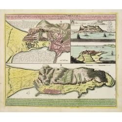
Neuester und exacter Plan .. von Gibraltar..
Scarce decorative plan of Gibraltar with fine views of the mount and Cidix. With a numbered key to the principal places in town.
Date: Nuremberg 1760
Selling price: ????
Please login to see price!
Sold
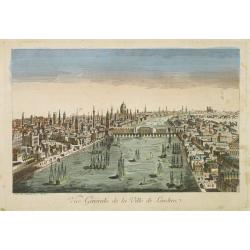
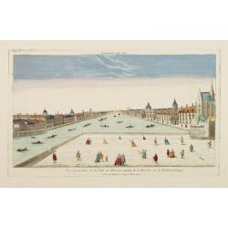
Vue générale de la ville de Londrea.
So-called optical print of London. The view is taken from a bridge on the Thames River and depicts several ships in the river and a great skyline.Daumont was a well-known...
Date: Paris 1760
Selling price: ????
Please login to see price!
Sold

Tabula comitatus Hollandiae. . .
Fine map of the provinces of North and South Holland. In upper left hand corner an inset with the islands of Texel and Vlieland.
Date: Augsburg 1760
Selling price: ????
Please login to see price!
Sold in 2024
Vue et Perspective de la Trinité a Vienne.
Decorative perspective view of a square in Vienna centered on the column which represents the Trinity. Published by Charpentier, who was active in rue St.Jacques in Paris...
Date: Paris, 1760
Selling price: ????
Please login to see price!
Sold in 2022

65e. Vüe d'Optique Représentant Le Palais de Cesar dans le Faubourg a Vienne appellé Favorita.
So-called optical print of a palace in Vienna, by Daumont who was a well-known publisher of optical prints, established in Paris.In the eighteenth and nineteenth centurie...
Date: Paris 1760
Selling price: ????
Please login to see price!
Sold in 2016

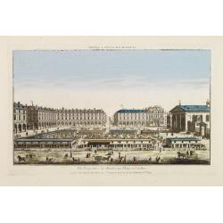
14e. Vüe d'Optique Representant La Grande Place de Petersbourg.
So-called optical print illustrating a perspective view of the portico of a Palace in Saint Petersburg. Published by Daumont, a well-known publisher of optical prints, es...
Date: Paris, 1760
Selling price: ????
Please login to see price!
Sold in 2017

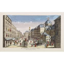
Vüe Méridionale de la Place Royale de Nancy.
So-called optical print illustrating the southern side of the Royal Square in Nancy. Published by Daumont, active at rue St.Martin, who was a well-known publisher of opti...
Date: Paris 1760
Selling price: ????
Please login to see price!
Sold in 2011

Vue perspective de la Place Royale de Nancy 1760.
So-called optical print illustrating a perspective view of the Royal Square in Nancy.Mondhare, active at rue St.Jacques a l'Hotel Saumur, was a well-known publisher of op...
Date: Paris, 1760
Selling price: ????
Please login to see price!
Sold in 2011
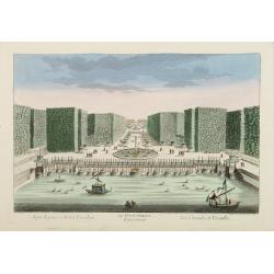
54e Vue d'Optique Representant Les Cascades de Versailles.
So-called optical print, illustrating a water basin with fountains in the gardens of Versailles.In the eighteenth and nineteenth centuries there were many popular special...
Date: Paris 1760
Selling price: ????
Please login to see price!
Sold in 2015

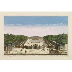
Vue du grand Bassin au bas des Tuilleries d'où l'on decouvre la place de Louis XV. Les Champs Elisée tel que cela doit être executé
So-called optical print illustrating a perspective view of the big basin in the Tuileries gardens, in Paris.Mondhare was a well-known publisher of optical prints, establi...
Date: Paris 1760
Selling price: ????
Please login to see price!
Sold
A view of Eugen princip Palace of Vien. / Vuë du Superbe Palais du Prince Eugene a Vienne.
Optical view of a square in Vienna, by Daumont who was a well-known publisher of optical prints, established in Paris.In the eighteenth and nineteenth centuries there wer...
Date: Paris 1760
Selling price: ????
Please login to see price!
Sold in 2016
Vue perspective de la Ville de Warsovie Capitale de la Marsovie sur la Wistule en Pologne.
So-called optical print illustrating a perspective view of Warsaw, namely the buildings overlooking the river Wisla.Mondhare was a well-known publisher of optical prints,...
Date: Paris 1760
Selling price: ????
Please login to see price!
Sold

Vue du Chateau de Maisons du Côté de l'Avenue..
Uncommon, so-called optical print illustrating a perspective view of a castle, probably Fontainebleau.In the eighteenth and nineteenth centuries there were many popular s...
Date: Paris, 1760
Selling price: ????
Please login to see price!
Sold in 2009
A view of the Road and Water-Works of Chelsea, with a Prospect of London.
So-called optical print illustrating the Somerset House with St. Mary's Church in the Strand London as indicated in the title. Shows figures walking and seated on the gro...
Date: Paris 1760
Selling price: ????
Please login to see price!
Sold

Vüe de la Maison Royalle de choisy du Côté du Jardin
So-called optical print illustrating a perspective view of a royal mansion in Choisy, near Paris.In the eighteenth and nineteenth centuries there were many popular specia...
Date: Paris, 1760
Selling price: ????
Please login to see price!
Sold in 2010
A View of the Tower taken upon the Thames. / La Rade de Londres.
So-called optical print illustrating a perspective view of the Tower as well as part of the Docks of London.In the eighteenth and nineteenth centuries there were many pop...
Date: London, c.1760
Selling price: ????
Please login to see price!
Sold
Vüe Perspective du Marché aux Fleures a Londres. (Covent Garden)
So-called optical print illustrating a perspective view of the flower market in London, now-a-days Covent Garden.In the eighteenth and nineteenth centuries there were man...
Date: Paris 1760
Selling price: ????
Please login to see price!
Sold
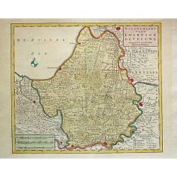
Nieuwe Kaart van't Kwartier de Veluwe. 1741.
Izaak Tirion (d. 1769) Amsterdam publisher. Published the Nieuwe en Beknopte handatlas', and ' Tegenwoordige staat van alle volkeren', a series of descriptions of countri...
Date: Amsterdam, c. 1760
Selling price: ????
Please login to see price!
Sold
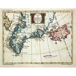
Carte de Groenland, 1770.
A map of Greenland and Iceland.
Date: Paris, c. 1760
Selling price: ????
Please login to see price!
Sold
Carte Réduite des Mers du Nord. 1758.
Jaques Nicolas Bellin (1702-720) was the most important French hydrographer of the 18th century. Sea-atlas 'Hydrographique Français' , 1756-65, atlas to accompany Prévo...
Date: Paris, 1760
Selling price: ????
Please login to see price!
Sold
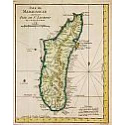
Isle de Madagascar autrement Isle de St. Laurent, 1747.
Jaques Nicolas Bellin (1702-720) was the most important French hydrographer of the 18th century. Sea-atlas 'Hydrographique Français' , 1756-65, atlas to accompany Prévo...
Date: Amsterdam, c. 1760
Selling price: ????
Please login to see price!
Sold
![Plan de Prag. [Manuscript plan of Prague - Praha]](/uploads/cache/24911-250x250.jpg)
Plan de Prag. [Manuscript plan of Prague - Praha]
Very nice manuscript plan of Prague and the castle. Not dated or signed. In upper left a numbered key 1-36 referring to the ramparts of the town and a scale (of 1:700 aul...
Date: [France] ca. 1760
Selling price: ????
Please login to see price!
Sold
Carte de Groenland, 1770.
A map of Greenland and Iceland.
Date: Paris, c. 1760
Selling price: ????
Please login to see price!
Sold in 2018
Borussiae Regnum..
With decorative title cartouche in upper part and an inset (155x115mm.) of Neufchatel.Expertly repaired map, with great presentation value.
Date: Augsburg, 1760
Selling price: ????
Please login to see price!
Sold in 2011

Veduta della Basilica e Piazza di S. Pietro in Vaticano
Etching of St. Peter's Basilica and Plazza in Vatican / Rome by Jean Barbault. It shows a authentic view of the Basilica in the middle of 18th century.
Date: Rome, 1760
Selling price: ????
Please login to see price!
Sold in 2009
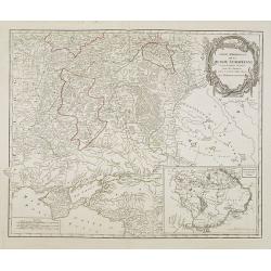
Partie Méridionale de la Russie Européenne. . .
Detailed map of Ukraine and Crimea. In the lower right corner inset map of Cosaques. A later edition, in which part of the address in the title cartouche was removed, and...
Date: Paris, ca 1760
Selling price: ????
Please login to see price!
Sold in 2008
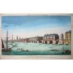
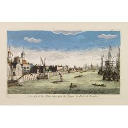
Premiere nouvelle vue d\'optique représentant une partie de la ville de Londres prise du faubourg de Saint Octave sur la Tamise
So-called optical print showing a fine view of a bridge over the river Thames in London, with houses built on it. Several ships on the river, large and small, complete th...
Date: Paris, ca. 1760
Selling price: ????
Please login to see price!
Sold in 2009

Vue du Palais Royal de Hampton Court a 15 Mille de Londres.
So called optical print of the Hampton Court Royal Palace Royal Gardens near London. Published by the brothers Chéreau, active in Paris at rue St. Jacques au dessus de l...
Date: Paris, 1760
Selling price: ????
Please login to see price!
Sold in 2019
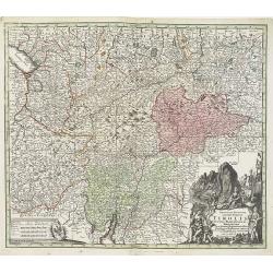
Principali Dignitate Gaudens Comitat. Tirolis Episcopat. Tridentinum et Brixiensem ut et Comitat. Brigantinum Feldkirch Sonneberg et Pludentinum contingens quo ad omnes Urbes. . .
The mountainous borders of Italy, Switzerland & Austria, with an allegorical title cartouche lower right. Centered on the course of the Inn River and including Lake G...
Date: Nuremberg, ca. 1760
Selling price: ????
Please login to see price!
Sold in 2020