![[LXXXII. Predicatore Giaponese].](/uploads/cache/35018-250x250.jpg)
[LXXXII. Predicatore Giaponese].
Aquatint depicting a Japanese preacher and his audience, engraved by A. Rancoti, Plate N°82.From Giulio Ferrario's work Le Costume Ancien et Moderne ou Histoire du gouve...
Date: Milan, 1827
Selling price: ????
Please login to see price!
Sold in 2020
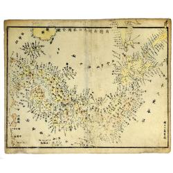
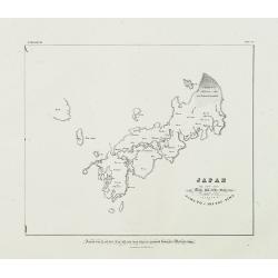
JAPAN, ca 1830.
Woodcut, colored map of Japan, with Japanese text.
Date: c 1830
Selling price: ????
Please login to see price!
Sold in 2019
![[untitled plan of Osaka]](/uploads/cache/99163-250x250.jpg)
[untitled plan of Osaka]
Rare Japanese colored woodcut printed map of Osaka. Very large size and scale, with excellent detail. Dated from the Tenpo era which was from 1830-44!It indicates the Osa...
Date: Japan, c. 1837
Selling price: ????
Please login to see price!
Sold in 2009
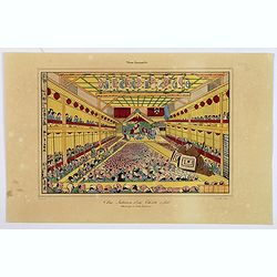
Vue Interieure d'un Theatre a Jedo.
A typical theatre scene in Tokyo, as seen during the first half of the nineteenth century. It shows a packed theatre, looking at events being reenacted on stage, and else...
Date: Paris, ca 1837
Selling price: ????
Please login to see price!
Sold in 2018
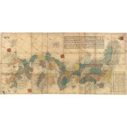
![KAISEI NIHON YOCHI ROTEI ZENZU. [A Revised Route Map of Japan showing the fiefs and distances]](/uploads/cache/93941-250x250.jpg)
KAISEI NIHON YOCHI ROTEI ZENZU. [A Revised Route Map of Japan showing the fiefs and distances]
A multi-sheet woodcut map, showing Japan orientated north west to south east, compass roses, with various text blocks giving information on roads, crops of each Daimyo, t...
Date: Edo, Chojiya Heibei et al.1846
Selling price: ????
Please login to see price!
Sold in 2014
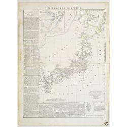
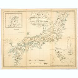
Impero del Giappone. Questa Carta e stata eseguita su quella pubblicata in Londra nel 1835, dalla Societa per la diffusione delle utili conoscenze, e su quella di Arrowsmith. . .
An interesting and uncommon detailed and large-scale Italian map of Japan published in Naples in Benedetto Marzolla's Atlante Geographico . Inset: Porto di Nangasaki (sca...
Date: Naples, 1847
Selling price: ????
Please login to see price!
Sold in 2011
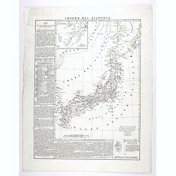
Impero del Giappone. . .
An interesting and uncommon detailed and large-scale Italian map of Japan published in Naples in Benedetto Marzolla's Atlante Geographico . Inset: Porto di Nangasaki (sca...
Date: Naples, 1847
Selling price: ????
Please login to see price!
Sold in 2020
Map of the Districts and Countries of Great Japan
This is a spectacular, large format folding map of Japan by Takashiba Ei'San'Yu, dated 1849. The map presents the primary Japanese islands of Kyushu, Honshu, Shikoku and ...
Date: Japan, 1849
Selling price: ????
Please login to see price!
Sold in 2023
![[Edo period woodcut plan of Edo or Tokyo]](/uploads/cache/27903-250x250.jpg)
[Edo period woodcut plan of Edo or Tokyo]
Nice plan of Edo (present-day Tokyo) oriented with north to the right. Shows main temples and shrines pictorially. Includes distance chart and legend. In color, folded, l...
Date: Japan c. 1850
Selling price: ????
Please login to see price!
Sold in 2009
![Ansei kaisei fugo on Edo ezu. [Tokyo]](/uploads/cache/40776-250x250.jpg)
Ansei kaisei fugo on Edo ezu. [Tokyo]
An extraordinary color-printed town-plan now-a-day Tokyo, and a fine example of Edo cartography. The present map is exceptionally detailed with accurate delineations of d...
Date: Edo, ca. 1850
Selling price: ????
Please login to see price!
Sold in 2017
![[Plan of Edo / Tokyo.]](/uploads/cache/41893-250x250.jpg)
[Plan of Edo / Tokyo.]
A fascinating and impressive town plan of Edo/Yedo in Japan, during the Tokugawa Shogunate of the 1850s. After 1868, Yedo was renamed Tokyo.The publisher Owariya produced...
Date: Tokyo, ca. 1850
Selling price: ????
Please login to see price!
Sold in 2020

Portrait of Otaksa.
Fine portrait of Otaksa, published in Nippon . Von Siebold was born in Wurtzburg, in Germany, and worked for the Dutch government as a doctor in Java. In Japan, where Von...
Date: Leiden, 1832-1852
Selling price: ????
Please login to see price!
Sold in 2009
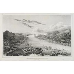
Gezigt op de haven en de baai van Nagasaki.
A birds-eye view showing Deshima, the trading post of the V.O.C., and Nagasaki bay. Von Siebold was born in Würtzburg, in Germany, and worked for the Dutch government as...
Date: Leiden, 1832-1852
Selling price: ????
Please login to see price!
Sold in 2010

Acer micranthum.
From his famous work 'Flora Japonica'. Von Siebold was born in Würtzburg, in Germany, and worked for the Dutch government as a doctor in Java. In Japan, where Von Siebol...
Date: Leiden, 1852
Selling price: ????
Please login to see price!
Sold in 2009
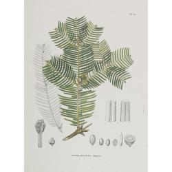
Cephalotaxus drupacea.
From his famous work 'Flora Japonica'. Von Siebold was born in Würtzburg, in Germany, and worked for the Dutch government as a doctor in Java. In Japan, where Von Siebol...
Date: Leiden, 1852
Selling price: ????
Please login to see price!
Sold in 2009
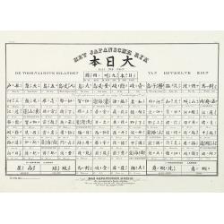
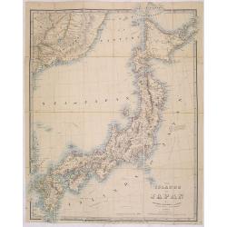
Het Japansche Ryk. De Voornaamste Eilanden van Hetzelve Zijn. Das Japanische Reich. Die vorzügliehsten Inseln desselben . . . Neben und Schutzländer.
A table prepared by Von Siebold showing the names of the different Japanese islands in Japanese and Latin.Von Siebold was born in Wurzburg, in Germany, and worked for the...
Date: Leiden, 1832-1852
Selling price: ????
Please login to see price!
Sold in 2010
Japan ten tyde van Zin-mu-ten-woo 660 v.c.
Historical map of Japan for the year 660 B.C., during the regime of Zin-mu-ten-woo. According to the map Japan was known as "Jama-to v. Aki-Tsu-Sima.The tip of Korea...
Date: Leiden 1832-1852
Selling price: ????
Please login to see price!
Sold in 2014

Muzijkinstrumenten - Samisen / Kokiu.
A japanese woman playing the samisen and a men playing kokiu.Von Siebold was born in Würtzburg, in Germany, and worked for the Dutch government as a doctor in Java. In J...
Date: Leiden, 1832-1852
Selling price: ????
Please login to see price!
Sold in 2012
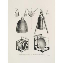
MUZJIKINSTRUMENTEN. MUSIKINSTRUMENTE. Tab.V.
Several Japanese instruments.Philipp Franz von Siebold (1796-1866) was a physician, researcher and teacher who joined the Dutch East Indian army and travelled to Japan on...
Date: Leiden, 1852
Selling price: ????
Please login to see price!
Sold in 2021
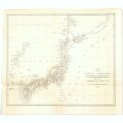
Map of the Japan Islands. . .complied by order of Commodore M.C. Perry, USN.
A map of Japan by Maury and Bent under the orders of Commodore Perry, 1855. Very good detail of the many islands with cities marked and with decent topographical informat...
Date: New York, 1855
Selling price: ????
Please login to see price!
Sold in 2020
![[untitled map of Japan]](/uploads/cache/99952-250x250.jpg)
[untitled map of Japan]
Superb 19th century woodblock printed map of Japan. Ansei 4 = 1857. Edo period. Also with parts of Korea (Chosen) and Hokkaido (Ezo). Shows the entire island, with much d...
Date: Japan, c1857
Selling price: ????
Please login to see price!
Sold in 2011

Japan.
The Empire of Japan with part of the continent of Asia and the New Boundary between the Russian and Chinese borders. From the Weekly Dispatch Atlas.
Date: London, 1858
Selling price: ????
Please login to see price!
Sold in 2013
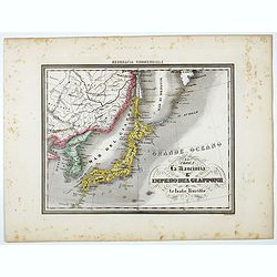
La Corea La Manciuria L' Impero del Giappone e le Isole Kurille.
Uncommon map of Korea, Japan and part of China, prepared by Francesco Costantino Marmocchi. Above the map "Geografia Commerciale". From "Il Globo Atlante d...
Date: Genova, Paolo Rivara fu Giacomo, 1858
Selling price: ????
Please login to see price!
Sold in 2022
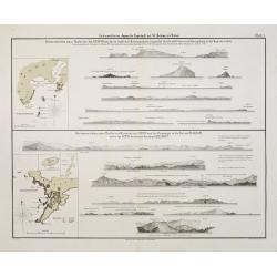
Küstenansichten eines Theiles der Insel NIPPON..
Prepared by Officer S.M.S. Arcona during the German expedition of 1860-1861 to South East Asia. Lithographed by Lippold and printed by C.Ulrich of Berlin. Sheet 1 from a ...
Date: Berlin, 1863
Selling price: ????
Please login to see price!
Sold in 2013
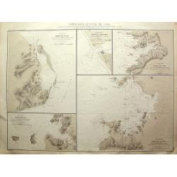
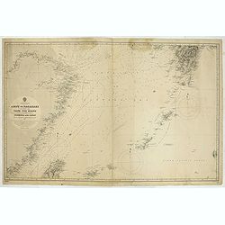
Ports dans le Canal Kii (Japon).
Rare Admiralty Chart with 5 large scale maps on one sheet: Shows the harbour of Jura; the Hachken river, Yura No Uchi, Bay of Tanabe, Bay of Osaki.All 5 charts with much ...
Date: Paris, 1864
Selling price: ????
Please login to see price!
Sold in 2011
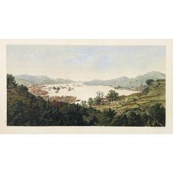
Nangasaki.
A fine bird's-eye view showing Deshima (the head quarter of the V.O.C.) and Nagasaki bay. From Die Preussische Expedition nach Ost Asien . With many European ships in the...
Date: Berlin, 1864
Selling price: ????
Please login to see price!
Sold in 2015
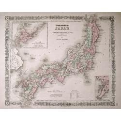
Johnson's Japan; Nippon, Kiusiu, Sikok, Yesso and the Japanese Kuriles.
An attractive map with insets of Yesso and the Japanese Kuriles, and the Bay of Nagasaki. The detailed map was compiled from the maps of Siebold and the surveys of the U....
Date: New York, c1864
Selling price: ????
Please login to see price!
Sold in 2013
The islands of Japan by James Wyld..
Very detailed map of Japan, including part of the coast of Korea with Busan harbor. Including tracks of explorers, Krusenstern (1804), Providence (1796), Argonaut (1797),...
Date: London, 1868
Selling price: ????
Please login to see price!
Sold in 2013
![[untitled map of Japan]](/uploads/cache/91045-250x250.jpg)
[untitled map of Japan]
Superb 19th century woodblock printed map of Japan. Very large size and scale, with excellent detail. Strikingly decorative and skillfully executed. With nice hand-colori...
Date: Japan, c1870
Selling price: ????
Please login to see price!
Sold in 2010
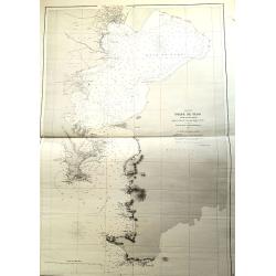
South Japan Marine Chart.
Marine chart by Amirale Cécile in 1846, but corrections in 1870 and 1873 by the Dépôt général de la marine. Meji period. A wonderful chart of the very southern part ...
Date: Paris, 1873
Selling price: ????
Please login to see price!
Sold in 2021
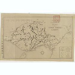
(Plan of Hiogo Treaty Limits)
Map of the new prefecture with Japanese and English descriptions. In lower right an key to "Position of Government Office, boundaries, road and railways. On January ...
Date: Meiji 10 = 1877
Unusual Chart Of the Tokyo Yokohama Bay.
"Golfe de Yedo" le sud du Japon" d'aprés l'amirauté Britannique. 1872 corrections in 1876-78-79. Dépôt général de la marine. 1 x tearing paper off ma...
Date: Paris, 1879
Selling price: ????
Please login to see price!
Sold in 2021
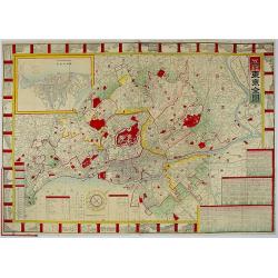
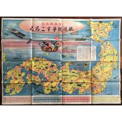
Map of Tokyo.
A very attractive folded engraved map of Tokyo in the Japanese and English languages in woodblock color. It shows views of tourist attractions. It includes an address cha...
Date: Tokyo, 1887
Selling price: ????
Please login to see price!
Sold in 2018
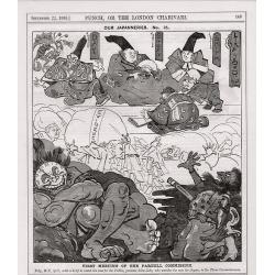
A complete set of 21 humorous Punch prints with Japan interest 1888.
This set of 21, numbered 1 – 21 cartoon prints are from Punch published between May1888 – November 1888. Mostly engraved by Joseph Swain. Joseph Swain was one of the ...
Date: London, 1888
Selling price: ????
Please login to see price!
Sold in 2017
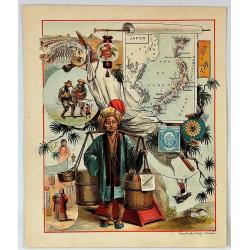
Japon
An interesting chromolithograph semi-cartoon map of Japan with several views from the middle 19th century.It features a boy carrying water, men playing with puppets, and ...
Date: Haarlem, ca. 1890
Selling price: ????
Please login to see price!
Sold in 2017
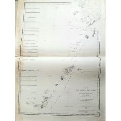
Japan - The Kuril Islands from Nipon to Kamchatka..
Large chart representing the Kuril Islands in the Pacific Ocean. Some of the capes and bays are highlighted in red and yellow.Contains 7 inset plans of bays, anchorages a...
Date: London, 1893, updated 1895
Selling price: ????
Please login to see price!
Sold in 2021
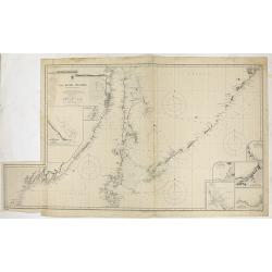
China & Japan - Amoy to Nagasaki including the Yang Tse Kiang and the Islands between Formosa and japan..
Large chart centered on the East Sea between China and Japan. In upper right corner tip of island of Kyushu. Lower left northern tip of Taiwan, and in center Okinawa. Som...
Date: London, 1891, updates to 1897
Selling price: ????
Please login to see price!
Sold in 2021
Tetsudo kyoso Sugoroku [Railway Race Sugoroku)
A scarce Japan map produced ca. 1925 (Taisho 14) board for the Japanese game known as 'sugoroku'. The board depicts the islands of Japan oriented in a northwesterly direc...
Date: Sogoroku-taisho14-1925
Selling price: ????
Please login to see price!
Sold in 2017
Karte vom japanischen Reiche, nach Originalkarten und astronomischen Beobachtungen der Japaner,die Inseln Kiusiu, Sikok und Nippon. / Philipp Franz von Siebold.
An early 20th-century reproduction of this important map of Japan was made in 1840 by German physician and traveler Philipp Franz Balthasar von Siebold. During his travel...
Date: Tokyo, ca. 1940
Selling price: ????
Please login to see price!
Sold in 2014
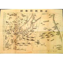
Imperial Defense Map.
Interesting piece of ephemera from a supplement in a Japanese boys' magazine published during World War II showing battle scenes and American & Japanese naval positio...
Date: Japan, c. 1941
Selling price: ????
Please login to see price!
Sold in 2012
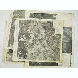
Ryukyo-Retto Photo maps 1:10,000 Secret. First edition. (Six maps)
A group of six printed maps for the US army of photos made in September 1944 of Nakagami-gun (country) including Okinawa. Kin m (Sheet 3626-II m), Yonaburu b (sheet 3625-...
Date: Washington, September 1944
Selling price: ????
Please login to see price!
Sold in 2014
Ryukyo-Retto Photo maps 1:10,000 Secret. First edition. (Six maps)
A group of six printed maps for the US army of photos made in September 1944 of Nakagami-gun (country) including Okinawa. Kin m (Sheet 3626-II m), Yonaburu b (sheet 3625-...
Date: Washington, September 1944
Selling price: ????
Please login to see price!
Sold in 2012
![Honorable War Plants [in Japan]](/uploads/cache/39798-250x250.jpg)
Honorable War Plants [in Japan]
Map depicting Japan and industrial war-plants. Design by Robert Macfarlane Chapin Jr.. In right hand side : Enlargement of original map drawn for TIME The Weekly News Mag...
Date: New York , Time Magazine, 1944
Selling price: ????
Please login to see price!
Sold in 2017
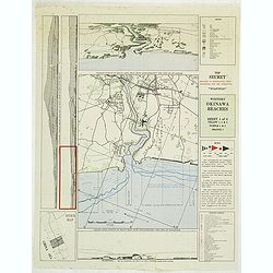
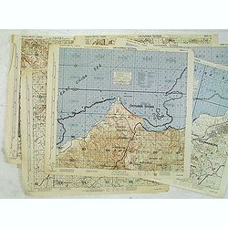
Western Okinawa Beaches Sheet 4 of 6. Top Secret reduced to restricted upon departure for the operation. (Lot contains 2 copies of the map.)
Top secret intelligy map of Western Okinawa Beaches prepared by Comphisgroup twelve and Phisspac Intelligence. With several inset maps and keys. On verso the Hourly heigh...
Date: Washington, 1945
Selling price: ????
Please login to see price!
Sold in 2012
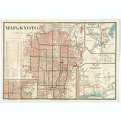
Kyoto and Vicinity with Shopping District.
An attractive colored plan of the Japanese city of Kyoto, with smaller insets of a plan of Maruyama Park, a map of Kyoto and Vicinity, and a plan of Momoyama. Complete wi...
Date: Kyoto, ca. 1950
Selling price: ????
Please login to see price!
Sold in 2018
