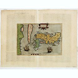
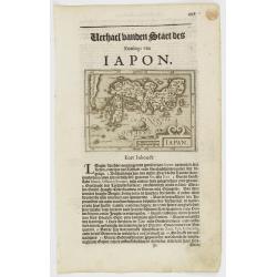
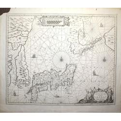
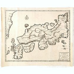
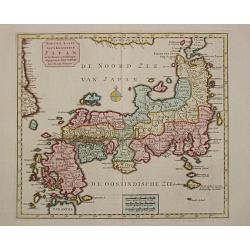
Japonia Regnum.
Very rare map and one of the earliest views of Japan and Korea and was published in a German edition of Botero's "Theatrum Principum Orbis Universi."This is a v...
Date: Cologne, Lambert Andreas, 1596
Selling price: ????
Please login to see price!
Sold in 2015
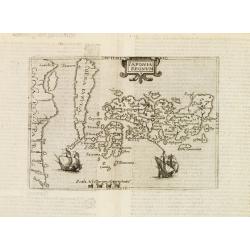
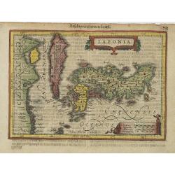
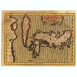
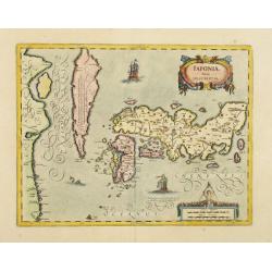
Iaponia regnum.
One of the earliest printed map of Japan and the first copy after Ortelius / Teixeira.Published in the German edition of José de Acosta's De Natura Nova Orbis, first pub...
Date: Cologne c. 1598
Selling price: ????
Please login to see price!
Sold
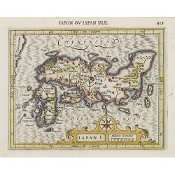
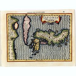
Iapan I.
Map of Japan from the first French-text edition of Jodocus Hondius' Atlas Minor.Shortly after the publication of the big folio-atlases the need was apparently felt for a ...
Date: Amsterdam, 1608
Selling price: ????
Please login to see price!
Sold in 2008
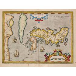
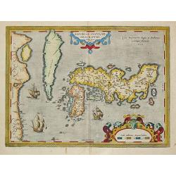
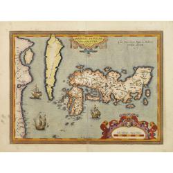
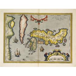
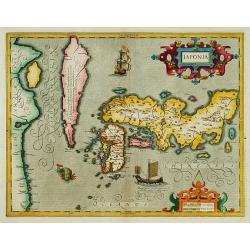
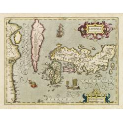
Iaponiae Insulae Descriptio; Ludoico Teisera Auctore.
This landmark map was the first map of Japan published in a European atlas. Ortelius received the map from Ludovico Teixeira, a Portuguese Jesuit cartographer and mathema...
Date: Antwerp, Robert Bruneau, 1609
Selling price: ????
Please login to see price!
Sold in 2019
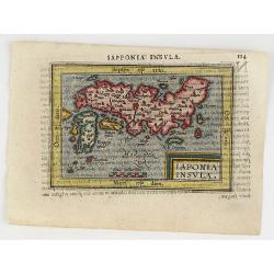
Iaponia Insula.
A very nice miniature map of Japan, with major cities named, title cartouche at the bottom and the sea is stipple engraved. The map was engraved by the brothers Ambrose a...
Date: Antwerp, 1609
Selling price: ????
Please login to see price!
Sold in 2018
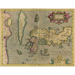
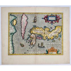
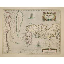
Japonia.
The first map of Japan published in a European atlas. Ortelius received the map from Ludovico Teixeira, a Portuguese Jesuit cartographer and mathematician. While Teixeira...
Date: Antwerp, Robert Bruneau, 1609
Selling price: ????
Please login to see price!
Sold in 2020
Iaponia.
A close derivative of the Teixeira map introduced by Ortelius in 1595. Hondius, however, makes note of Korea by including an inscription stating that it is not known whet...
Date: Amsterdam, 1611
Selling price: ????
Please login to see price!
Sold in 2010
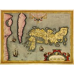
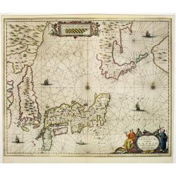
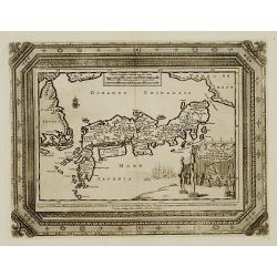
Japoniae insulae descriptio.
The first printed map of Japan to appear in an atlas. It was drawn by the Portuguese Jesuit Luiz Teixeira and depicts Korea as an island. Japan was probably identified wi...
Date: Antwerp 1595-1612
Selling price: ????
Please login to see price!
Sold
Japoniae insulae descriptio.
The first printed map of Japan to appear in an atlas. It was drawn by the Portuguese Jesuit Luiz Teixeira and depicts Korea as an island. Japan was probably identified wi...
Date: Antwerp 1595-1612
Selling price: ????
Please login to see price!
Sold
Japoniae insulae descriptio.
The first printed map of Japan to appear in an atlas, in a first state. It was drawn by the Portuguese Jesuit Luiz Teixeira and depicts Korea as an island. Japan was prob...
Date: Antwerp, 1595-1612
Selling price: ????
Please login to see price!
Sold in 2009

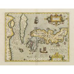
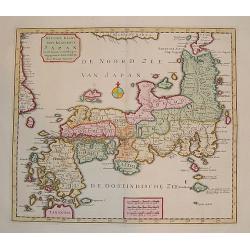
Japoniae Nova Descriptio.
Very decorative map of Japan based on the Ortelius/Teixeira model with Honshu, Kyushu, and Shikoku depicted with approximately the correct proportions. Korea is shown as ...
Date: Amsterdam, 1613
Selling price: ????
Please login to see price!
Sold in 2018
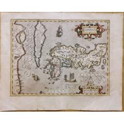
Iaponia.
Beautiful map of Japan as perceived by Europeans at the beginning of the 17th century, first issued in the 1606 Mercator-Hondius atlas, and in subsequent editions over th...
Date: Amsterdam, 1619
Selling price: ????
Please login to see price!
Sold in 2020
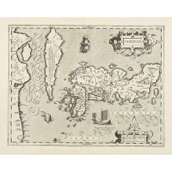
Japonia.
Jodocus Hondius' fine map early 17th century map of the islands of Japan, first issued as one of the new maps in the expended Mercator Hondius Atlas of 1606.The map is cl...
Date: Amsterdam 1606-1620
Selling price: ????
Please login to see price!
Sold
Iapan.
Small map of Japan, surrounded by text in Dutch. Nicolaes de Clerck (de Klerc) was active as engraver and publisher in Delft from 1599-1621.Included in the rare book : We...
Date: Amsterdam, Cloppenburch, 1621
Selling price: ????
Please login to see price!
Sold
Japonia.
Drawn to a smaller scale than the 1607 map: including Korea and part of China. Engraved by Petrus Kaerius.
Date: Amsterdam, 1628
Selling price: ????
Please login to see price!
Sold in 2009
IAPONIA.
This is one of the most significant maps Hondius the elder added to his first publication of the Mercator atlas in 1606. Based on the 1595 Abraham Ortelius map, but with ...
Date: Amsterdam 1630
Selling price: ????
Please login to see price!
Sold
IAPONIA.
This is one of the most significant maps Hondius the elder added to his first publication of the Mercator atlas in 1606.Based on the 1595 Abraham Ortelius map, but with a...
Date: Amsterdam 1630
Selling price: ????
Please login to see price!
Sold
Iaponia.
Jodocus Hondius' fine map early 17th century map of the islands of Japan, first issued as one of the new maps in the expended Mercator Hondius Atlas of 1606.The map is cl...
Date: Amsterdam 1630
Selling price: ????
Please login to see price!
Sold
IAPONIA.
Early miniature map of Japan and Korea from the rare Cloppenburg edition slightly larger format and more scarce edition of the Mercator/Hondius "Atlas Minor". E...
Date: Amsterdam, 1630
Selling price: ????
Please login to see price!
Sold in 2016
IAPONIA.
Early miniature map of Japan and Korea from the rare Cloppenburg edition "Atlas Sive Cosmographicae Meditationes De Fabrica Mundi Et Fabricati Figura", slightly...
Date: Amsterdam, 1630
Selling price: ????
Please login to see price!
Sold in 2019
Iaponia.
One of the most significant maps Hondius the elder added to his first publication of the Mercator atlas in 1606. Based on the 1595 Abraham Ortelius map, but with added de...
Date: Amsterdam, 1630
Selling price: ????
Please login to see price!
Sold in 2019
IAPONIAE Nova Descriptio.
2nd state of Hondius map. Janssonius replaced the Japanese ship with a European one. Korea shown as an island.
Date: Amsterdam, 1639
Selling price: ????
Please login to see price!
Sold in 2019
IAPONIAE Nova Descriptio.
2nd state of Hondius map. Janssonius replaced the Japanese ship with a European one.
Date: Amsterdam, 1639
Selling price: ????
Please login to see price!
Sold in 2009
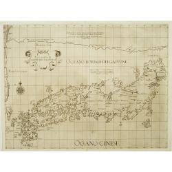
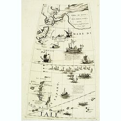
Asia carta di ciasete piu moderna. (Japan)
Rare Japan map of the Blancus/Moreira type. The place names follow Ginnaro, though he invented numerous additional imaginative names. From the first edition of hisDell'Ar...
Date: Florence 1646
Selling price: ????
Please login to see price!
Sold
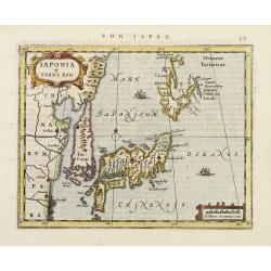
Iaponia et Terra Eso.
Detailed miniature map of Japan with Korea as an island, from a German text edition of his Atlas Minor. Engraved by Petrus Kaerius.
Date: Amsterdam (1628) 1648
Selling price: ????
Please login to see price!
Sold
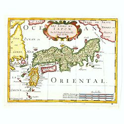
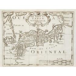
Les Isles du Iapon.
A very pleasant map of the island of Japan as seen in the mid-seventeenth century by the important and influential French cartographer, Nicolas Sanson. The map also shows...
Date: Paris, ca. 1652
Selling price: ????
Please login to see price!
Sold in 2019
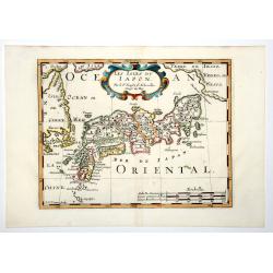
LES ISLES DU IAPON (Japan.)
A very pleasant map of the island of Japan as seen in the mid-seventeenth century by the important and influential French cartographer, Nicolas Sanson. The map also shows...
Date: Paris, ca 1652
Selling price: ????
Please login to see price!
Sold in 2019
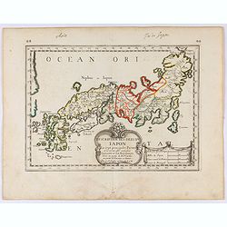
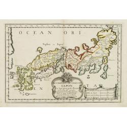
Description des Isles du Iapon. . .
Map of Japan prepared by N.Sanson and published by Pierre Mariette.Published in an early edition of the small Sanson atlas L'Europe Dediée a Monseigneur . . . Le Tellier...
Date: Paris, P. Mariette, 1656
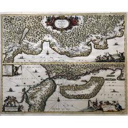
Nova et accurata Japoniae terrae Esonis, ac Insularum. . .
Johannes Janssonius' important map of Japan, notable for its detail of Hokkaido, the first printed map to use the detailed manuscript charts of Maarten de Vries from his ...
Date: Amsterdam, 1658
Selling price: ????
Please login to see price!
Sold in 2011
Nova et Accurata Japoniae, Terrae Esonis, ac Insularum Adjacentium ex Novissima Detectione Descriptio. Apud Ioannem Ianssonium
This edition is without text on the back.
Date: Amsterdam, c. 1660
Selling price: ????
Please login to see price!
Sold in 2008
Description des Isles du Iapon. . .
Map of Japan prepared by N.Sanson and published by Pierre Mariette.Published in an early edition of the small Sanson atlas L'Europe Dediée a Monseigneur . . . Le Tellier...
Date: Paris, P. Mariette, 1667
Selling price: ????
Please login to see price!
Sold in 2008
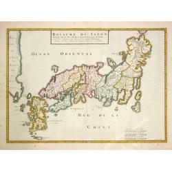
Royaume de Japon.
The second state of Père Philippe's map of Japan.
Date: Paris, N. Sanson,1676
Selling price: ????
Please login to see price!
Sold in 2015
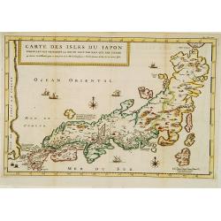
Carte des Isles du Japon Sequels est remarque la Route..
This uncommon map of Japan, which is reduced version of his larger map, contains comments about the nature of the country. For instance, Ocsaqui (Okazaki, near Nagoya) is...
Date: Paris/Amsterdam 1679
Selling price: ????
Please login to see price!
Sold
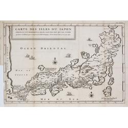
Carte des Isles du Japon Esquelles est remarque la Route ?
This uncommon map of Japan contains comments about the nature of the country. For instance, Ocsaqui (Okazaki, near Nagoya) is said to have the most beautiful women. Lake ...
Date: Paris, 1679
Selling price: ????
Please login to see price!
Sold in 2009
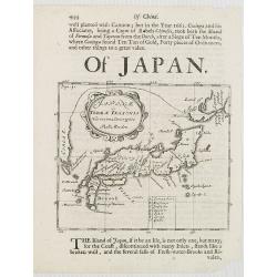
Japonae ac Terrae Iessonis Novissima Descriptio.
Hokkaido is shown as being connected to Korea. With a description in English giving brief information on Japan and Korea and a rather detailed description of Taiwan (Form...
Date: London, 1680
Selling price: ????
Please login to see price!
Sold in 2008
Route d' Osacca à Iedo / Route de Nangasacqui a Osacca.
A rare folio-sized copper engraving of Japan with the route from Osaka to Jedo (Tokyo) and the route from Nagasaki to Osaka. On the top map the details of the route from ...
Date: Amsterdam, 1680
Selling price: ????
Please login to see price!
Sold in 2021
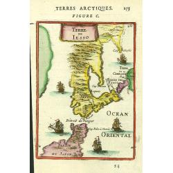
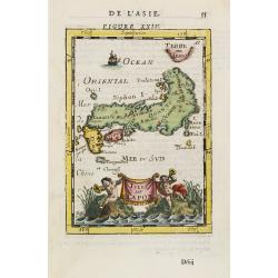
Terre de Iesso.
A charming small map of Hokkaido and the northern part of Honshu, by Allain Manneson Mallet (1630-1706), a well travelled military engineer and geographer who worked in 1...
Date: Paris, 1683
Selling price: ????
Please login to see price!
Sold in 2016
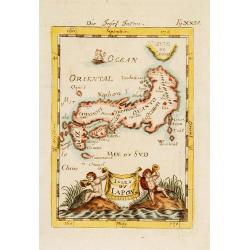
Isles du Japon.
A charming late 17th century French map with a very decorative title cartouche showing trumpet-blowing cherubs.From the German text edition published by Davis Zunners. Je...
Date: Franckfurt 1684
Selling price: ????
Please login to see price!
Sold
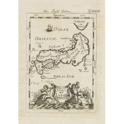
Isles du Japon. / Die Insel Japon.
A charming late 17th century French map of the islands of Japan with a very decorative title cartouche showing trumpet-blowing cherubs.From the German text edition publis...
Date: Frankfurt, 1684
Selling price: ????
Please login to see price!
Sold in 2008
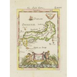
Isles du Japon.
A charming late 17th century French map with a very decorative title cartouche showing trumpet-blowing cherubs, by Allain Manneson Mallet (1630-1706), a well traveled mil...
Date: Paris, 1685
Selling price: ????
Please login to see price!
Sold in 2021
Isles du Japon.
A charming late 17th century French map with a very decorative title cartouche showing trumpet-blowing cherubs, by Allain Manneson Mallet (1630-1706), a well traveled mil...
Date: Paris, 1685
Selling price: ????
Please login to see price!
Sold in 2013
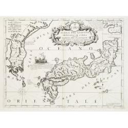
Isola del Giapone e penisola di Corea.
A most attractive and decorative map by Vincenzo Coronelli. An elaborate central title cartouche garlanded with intertwined flowers and dedicated to the Rev.de Fontaine o...
Date: Venice 1692
Selling price: ????
Please login to see price!
Sold
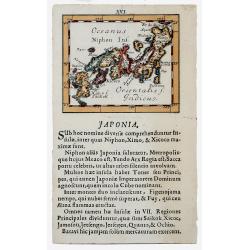
JAPONIA, 1692 (JAPAN)
Lovely miniature map showing Japan. The map is in a page within Latin text.
Date: Ulm, 1692
Selling price: ????
Please login to see price!
Sold in 2020
(Globe gore with part of Japan, Kamtchatka, Yedo and Ladrones)
Querter gore from his 110 centimeters in diameter globe of 1688 with part of Japan, eastern Siberia, Yedo and Ladrones. The sea is filled with a large Japanese navel batt...
Date: Venice, 1696 / 1697
Selling price: ????
Please login to see price!
Sold in 2012
Les Isles du Iapon.
Date: Amsterdam, 1700
Selling price: ????
Please login to see price!
Sold in 2009
William Adams Reystogt na Oost-Indien.. JAPAN. . .
Map of Japan and Korea. In lower right a fine title cartouche showing William Adams during an audience with the shogun, who sits under a baldachin on a fancifully portray...
Date: Leiden, 1707
Selling price: ????
Please login to see price!
Sold
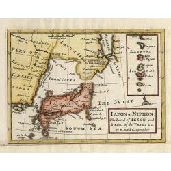
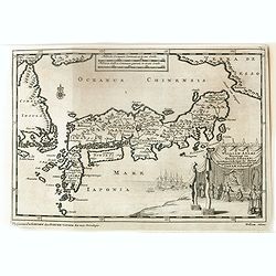
Iapon or Niphon, The Land of Iesso and Straits of the Vries &c.
This small, uncommon map of Japan, drawn on the Blaeu/Martini model, depicts a compact Honshu. The Land of Iesso is joined with the mainland and a faintly engraved coastl...
Date: London, 1712
Selling price: ????
Please login to see price!
Sold in 2009
![Wakan Sansai Zue (和漢三才図会 [Illustrated Sino-Japanese Encyclopedia - one volume].](/uploads/cache/40338-250x250.jpg)
Wakan Sansai Zue (和漢三才図会 [Illustrated Sino-Japanese Encyclopedia - one volume].
The Wakan Sansai Zue (和漢三才図会, lit. "Illustrated Sino-Japanese Encyclopedia") is an illustrated...
Date: Edo, 1712
Selling price: ????
Please login to see price!
Sold in 2017
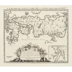
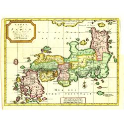
L'Empire Du Japon, Tiré Des Cartes Des Japonnois.
A good impression of this decorative map of Japan based on Reland's map of 1715, one of the earliest to use both Latin names and Japanese characters.With inset of the bay...
Date: Amsterdam 1719
Selling price: ????
Please login to see price!
Sold
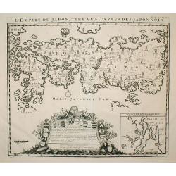
L'Empire du Japon, tire des cartes des Japonnois.
A good impression of this decorative map of Japan based on Reland's map of `1715, one of the earliest to use both Latin names and Japanese characters. With inset of the b...
Date: Amsterdam, 1719
Selling price: ????
Please login to see price!
Sold in 2009
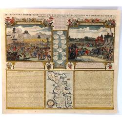
Succession des Empereurs du Japon avec une Description du Meutre de L'Empereur Cubo...
A composite sheet with a small map of Japan and two detailed views, one depicting the murder of the Emperor Cubo, the other, the reception of the Dutch ambassadors, each ...
Date: Amsterdam, 1719
Selling price: ????
Please login to see price!
Sold in 2019
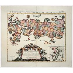
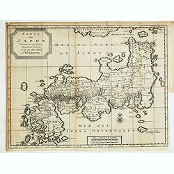
L'EMPIRE DU JAPON, TIRE DES CARTES DES JAPONNOIS (JAPAN).
A beautiful old colored map, which was published by Henri Chatelain in 1719 for his 'Atlas Historique'. Published from 1705 to 1720, the 'Atlas Historique' was intended f...
Date: Amsterdam, 1719
Selling price: ????
Please login to see price!
Sold in 2019
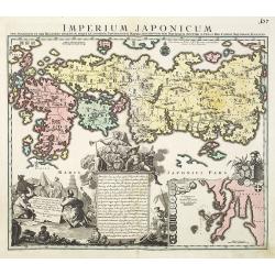
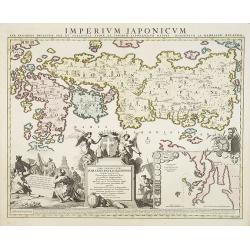
Imperium Japonicum.
The map is based on Englebert Kaempfer's map of 1727. It shows a much distorted outline for the Island of Japan and a wonderful decorative cartouche top left.The map was ...
Date: Augsburg 1720
Selling price: ????
Please login to see price!
Sold in 2011
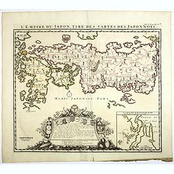
L'Empire du Japon, tiré des cartes des Japonnois.
A good impression of this decorative map of Japan based on Reland's map of 1715, one of the earliest to use both Latin names and Japanese characters. With inset of the ba...
Date: Amsterdam, 1720
Selling price: ????
Please login to see price!
Sold in 2017
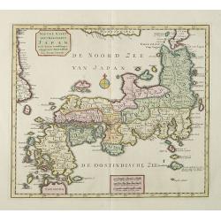
Nieuwe kaart van het eyland Japan.
The map originally appeared in Valentijn's book Oud en Nieuw Oost-Indien (Dordrecht/Amsterdam 1724/26). With in the right bottom corner the imprint J.van Braam en G. onde...
Date: Amsterdam 1724
Selling price: ????
Please login to see price!
Sold
Nieuwe kaart van het eyland Japan.
The map originally appeared in Valentijn's book Oud en Nieuw Oost-Indien (Dordrecht/Amsterdam 1724/26). With in the right bottom corner the imprint J.van Braam en G. onde...
Date: Amsterdam, 1724
Selling price: ????
Please login to see price!
Sold in 2008
Nieuwe Kaart van het Eyland Japan...
This copper engraved map of Japan divides the country by provinces, and extends to show the eastern border of Korea. Only the mountain ranges are depicted in the interior...
Date: Amsterdam, 1725
Selling price: ????
Please login to see price!
Sold in 2014
Nieuwe kaart van het Eyland Japan..
"The map originally appeared in Valentijn's book ""Oud en Nieuw Oost-Indien"" (Dordrecht/Amsterdam 1724/26). With in the right bottom corner the ...
Date: Amsterdam 1726
Selling price: ????
Please login to see price!
Sold
Nieuwe Kaart van het Eyland Japan verbeterd door Froncois Valentyn . . .
The map shows each of the Japanese provinces, with place names along the route from Nagasaki to Jedo and extends to show the eastern border of Korea. Only the mountain ra...
Date: Amsterdam, 1726
Selling price: ????
Please login to see price!
Sold in 2015
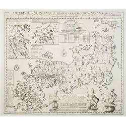
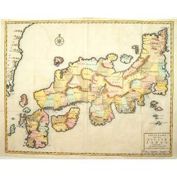
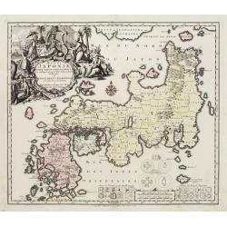
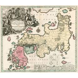
Imperium Japonicum in sexaginta et octo provincias..
The most important influence on European maps of Japan during the early years of the eighteenth century was that of E. Kaempfer based upon the manuscripts compiled during...
Date: The Hague 1727
Selling price: ????
Please login to see price!
Sold
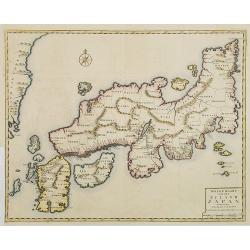
Imperium Japonicum in sexaginta et octo provincias divisum. Ex ipsorum Japonensium mappis & observationibus Kaempferianis. . .
The most important influence on European maps of Japan during the early years of the eighteenth century was that of E. Kaempfer based upon the manuscripts compiled during...
Date: The Hague, 1727
Selling price: ????
Please login to see price!
Sold in 2022
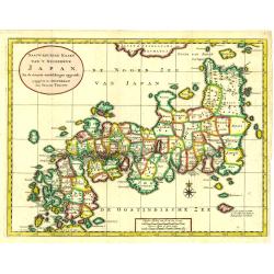
Nauw-keurige Kaart van 't Keizerryk Japan. . .
Tirion's first and decorative map of Japan modeled on Kaempfer's map.
Date: Amsterdam, 1728
Selling price: ????
Please login to see price!
Sold in 2018
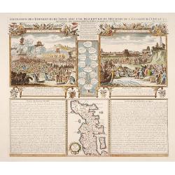
Succession des Empéreurs du Japon. . .
A fine folio sheet of engravings depicting the death of the Emperor Cubo and the arrival of one of the early Dutch embassies to Japan and a small map of the main island H...
Date: Amsterdam, 1728
Selling price: ????
Please login to see price!
Sold in 2014
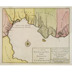
Carte de la route par terre depuis Jokaitz jusqu'à Fammamatz.
Detailed and attractive map from his important and comprehensive work. The land route from Yokkaichi to Hammamatsu. Kaempfer's greatest cartographic achievement was his r...
Date: The Hague, 1729
Selling price: ????
Please login to see price!
Sold in 2011
William Adams Reystogt na Oost-Indien.. JAPAN..
Map of Japan and Korea. In lower right a fine title cartouche showing William Adams during an audience with the shogun, who sits under a baldachin on a fancifully portray...
Date: Leiden 1729
Selling price: ????
Please login to see price!
Sold
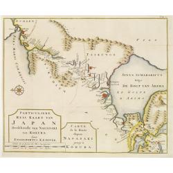
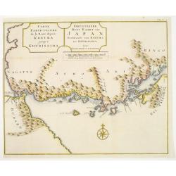
Carte de la route depuis Nagasaki jusqu' à Kokura.
Detailed and attractive map from his important and comprehensive work. The east-oriented route map from Nagasaki to Kokura.Kaempfer's greatest cartographic achievement wa...
Date: The Hague 1729
Selling price: ????
Please login to see price!
Sold
Carte de la route depuis Kokura jusqu' à Khurissima.
Detailed and attractive map from his important and comprehensive work. The route from Kokura to Kurishima.Kaempfer's greatest cartographic achievement was his route maps ...
Date: The Hague 1729
Selling price: ????
Please login to see price!
Sold
Carte du Japon, Dressée sur les Cartes Japonnoises. . .
Japan is still drawn in a nearly purely east-west position. At bottom right at the island of Fatsisio is mentioned: To this island the powerful men of Japan were sent Int...
Date: The Hague, 1732
Selling price: ????
Please login to see price!
Sold in 2019
Carte du Japon, Dressée sur les Cartes Japonnoises. . .
Japan is still drawn in a nearly purely east-west position. At bottom right at the island of Fatsisio is mentioned: To this island the powerful men of Japan were sent Int...
Date: The Hague, 1732
Selling price: ????
Please login to see price!
Sold in 2014
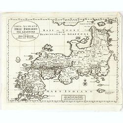
Carta Accurata dell' Imperio del Giappone. . .
Albrizzi published this Italian version of Tirion's first map of Japan. In the upper part of the map Jesso of Jesogasima Kamtzchatka is shown north of the Noto Peninsula....
Date: Venice, 1738
Selling price: ????
Please login to see price!
Sold in 2021
"Naauw-Keurige Kaart van 't Keizerryk Japan."
A stunning map of Japan based on the Kaempfer / Scheur type. The map is corrected from his previous work on Japan as it incorporates more accurate geography for the north...
Date: Amsterdam 1739
Selling price: ????
Please login to see price!
Sold
Regni Japoniae Nova Mappa Geographica..
The map is based on Englebert Kaempfer's map of 1727. It shows a much distorted outline for the Island of Japan and a wonderful decorative cartouche top left. The map was...
Date: Augsburg 1740
Selling price: ????
Please login to see price!
Sold
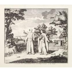
A Japanese couple.
A fine copperplate view of a Japanese couple in rather stylized dress.
Date: Amsterdam 1740
Selling price: ????
Please login to see price!
Sold
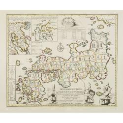
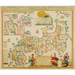
Het Koninkryk Japan, verdeelt in Acht en zestig Provintien in alle Naauwkeurigheid en Zorgvuldigheid Beschreven en uytgegeven Volgens de Oorspronkelyke Japansche Kaarten. . .
Map of Japan as well as two inset maps of Kamtschatka / Tschukotka and that Peninsula Oshima of Hokkaido. Title cartouche held by two Japanese Gods, Tossitoku and Nebis, ...
Date: Amsterdam, ca 1740
Selling price: ????
Please login to see price!
Sold in 2008
Nieuwe Kaart van 't Keizerrijk Japan.
Japan is still drawn in a nearly purely east-west position. At bottom right at the island of Fatsisio is mentioned: To this island the powerful men of Japan were sent Int...
Date: Amsterdam, 1740
Selling price: ????
Please login to see price!
Sold in 2009
Regni Japoniae nova mappa geographica.
One of the most decorative and elegant maps of Japan. The map is based on Englebert Kaempfer's map of 1727. It shows a much distorted outline for the Island of Japan and ...
Date: Augsburg, 1740
Selling price: ????
Please login to see price!
Sold in 2010
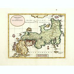
Imperio del Giappone.
Attractive early decorative copper plate map of the Kingdom of Japan with title a nice compass rose.The sea north of Japan is called Mare del Noort o Mare di tramontana d...
Date: Venice, 1740
Selling price: ????
Please login to see price!
Sold in 2017
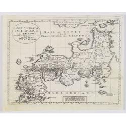
Carta Accurata dell' Imperio del Giappone. . .
Albrizzi published this Italian version of Tirion's map of Japan. In the upper part of the map Jesso of Jesogasima Kamtzchatka is shown north of the Noto Peninsula. At th...
Date: Venice, 1740
Selling price: ????
Please login to see price!
Sold in 2018
Nieuwe Kaart van t Keizerryk Japan.
Izaak Tirion (d. 1769) Amsterdam publisher. His ' Nieuwe en beknopte handatlas' saw 6 editions between before 1740 and after 1784. Also ' Tegenwoordige staat van alle vol...
Date: Amsterdam, c. 1745
Selling price: ????
Please login to see price!
Sold in 2015
Imperium Japonicum Per Regiones Digestum Sex et Sexaginta Atque Ipsorum Japonensium Mappis Descriptum Ab Hadriano Relando.
Prepared by H.Reland (1676-1718) a professor active in Utrecht and specialized in Asian languages, geography and religions. His first map was a map of Japan copied after ...
Date: Amsterdam, 1745
Selling price: ????
Please login to see price!
Sold
