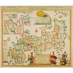
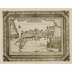
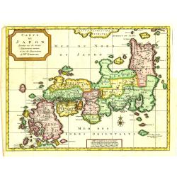
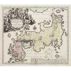
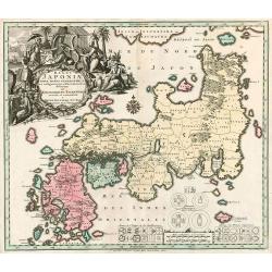
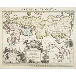
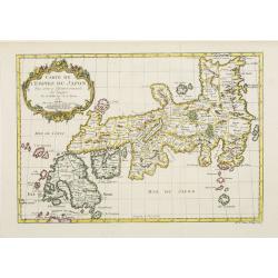
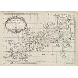
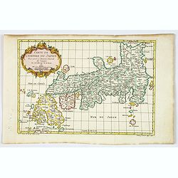
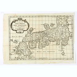
Imperium Japonicum in sexaginta et octo provincias divisum. Ex ipsorum Japonensium mappis & observationibus Kaempferianis. . .
The most important influence on European maps of Japan during the early years of the eighteenth century was that of E. Kaempfer based upon the manuscripts compiled during...
Date: The Hague, 1727
Selling price: ????
Please login to see price!
Sold in 2022

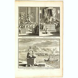
Ceremonie Nuptiale du Japon / Ceremonie Funebre du Japon.
Two fine copper engravings, on a large folio sheet. The highly detailed views show wedding and funeral ceremonies of Japan.Published in "Cérémonies et Coutumes rel...
Date: Paris, 1727
Selling price: ????
Please login to see price!
Sold in 2018
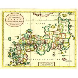
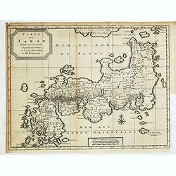
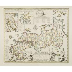
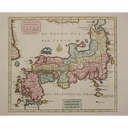
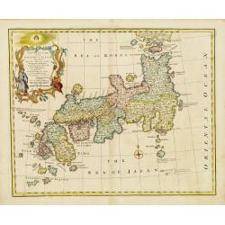
Nauw-keurige Kaart van 't Keizerryk Japan. . .
Tirion's first and decorative map of Japan modeled on Kaempfer's map.
Date: Amsterdam, 1728
Selling price: ????
Please login to see price!
Sold in 2018
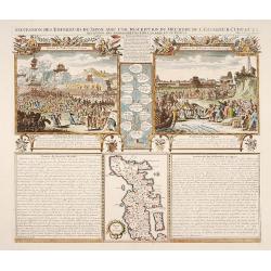
Succession des Empéreurs du Japon. . .
A fine folio sheet of engravings depicting the death of the Emperor Cubo and the arrival of one of the early Dutch embassies to Japan and a small map of the main island H...
Date: Amsterdam, 1728
Selling price: ????
Please login to see price!
Sold in 2014
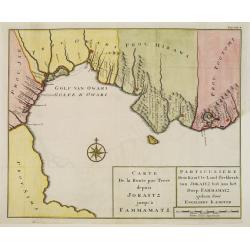
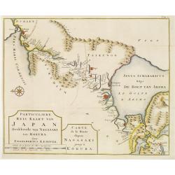
Carte de la route par terre depuis Jokaitz jusqu'à Fammamatz.
Detailed and attractive map from his important and comprehensive work. The land route from Yokkaichi to Hammamatsu. Kaempfer's greatest cartographic achievement was his r...
Date: The Hague, 1729
Selling price: ????
Please login to see price!
Sold in 2011
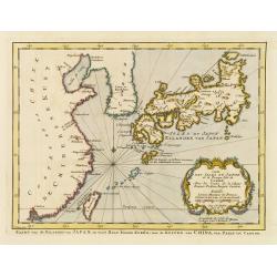
William Adams Reystogt na Oost-Indien.. JAPAN..
Map of Japan and Korea. In lower right a fine title cartouche showing William Adams during an audience with the shogun, who sits under a baldachin on a fancifully portray...
Date: Leiden 1729
Selling price: ????
Please login to see price!
Sold
Carte de la route depuis Nagasaki jusqu' à Kokura.
Detailed and attractive map from his important and comprehensive work. The east-oriented route map from Nagasaki to Kokura.Kaempfer's greatest cartographic achievement wa...
Date: The Hague 1729
Selling price: ????
Please login to see price!
Sold
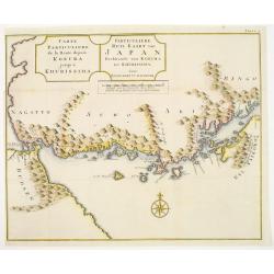
Carte de la route depuis Kokura jusqu' à Khurissima.
Detailed and attractive map from his important and comprehensive work. The route from Kokura to Kurishima.Kaempfer's greatest cartographic achievement was his route maps ...
Date: The Hague 1729
Selling price: ????
Please login to see price!
Sold
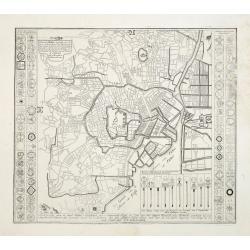
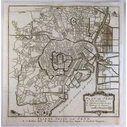
Plan de Jedo.. / Beschrijving van de stad JEDO..
The old Imperial capital, centered on the palace compound is shown in this detailed plan, based on Japanese printed plans of the late seventeenth century. From Kaempfer's...
Date: The Hague, 1732
Selling price: ????
Please login to see price!
Sold in 2008
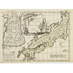
Carte du Japon, Dressée sur les Cartes Japonnoises. . .
Japan is still drawn in a nearly purely east-west position. At bottom right at the island of Fatsisio is mentioned: To this island the powerful men of Japan were sent Int...
Date: The Hague, 1732
Selling price: ????
Please login to see price!
Sold in 2019
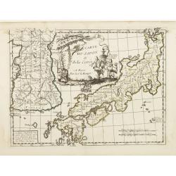
Carte du Japon, Dressée sur les Cartes Japonnoises. . .
Japan is still drawn in a nearly purely east-west position. At bottom right at the island of Fatsisio is mentioned: To this island the powerful men of Japan were sent Int...
Date: The Hague, 1732
Selling price: ????
Please login to see price!
Sold in 2014
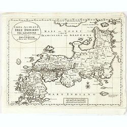
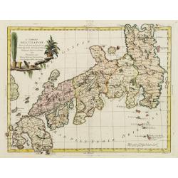
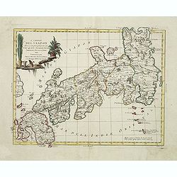
Carta Accurata dell' Imperio del Giappone. . .
Albrizzi published this Italian version of Tirion's first map of Japan. In the upper part of the map Jesso of Jesogasima Kamtzchatka is shown north of the Noto Peninsula....
Date: Venice, 1738
Selling price: ????
Please login to see price!
Sold in 2021
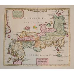
"Naauw-Keurige Kaart van 't Keizerryk Japan."
A stunning map of Japan based on the Kaempfer / Scheur type. The map is corrected from his previous work on Japan as it incorporates more accurate geography for the north...
Date: Amsterdam 1739
Selling price: ????
Please login to see price!
Sold
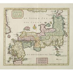
Regni Japoniae Nova Mappa Geographica..
The map is based on Englebert Kaempfer's map of 1727. It shows a much distorted outline for the Island of Japan and a wonderful decorative cartouche top left. The map was...
Date: Augsburg 1740
Selling price: ????
Please login to see price!
Sold

A Japanese couple.
A fine copperplate view of a Japanese couple in rather stylized dress.
Date: Amsterdam 1740
Selling price: ????
Please login to see price!
Sold
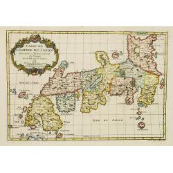
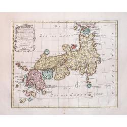
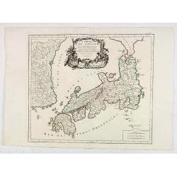
Het Koninkryk Japan, verdeelt in Acht en zestig Provintien in alle Naauwkeurigheid en Zorgvuldigheid Beschreven en uytgegeven Volgens de Oorspronkelyke Japansche Kaarten. . .
Map of Japan as well as two inset maps of Kamtschatka / Tschukotka and that Peninsula Oshima of Hokkaido. Title cartouche held by two Japanese Gods, Tossitoku and Nebis, ...
Date: Amsterdam, ca 1740
Selling price: ????
Please login to see price!
Sold in 2008
Nieuwe Kaart van 't Keizerrijk Japan.
Japan is still drawn in a nearly purely east-west position. At bottom right at the island of Fatsisio is mentioned: To this island the powerful men of Japan were sent Int...
Date: Amsterdam, 1740
Selling price: ????
Please login to see price!
Sold in 2009
Regni Japoniae nova mappa geographica.
One of the most decorative and elegant maps of Japan. The map is based on Englebert Kaempfer's map of 1727. It shows a much distorted outline for the Island of Japan and ...
Date: Augsburg, 1740
Selling price: ????
Please login to see price!
Sold in 2010
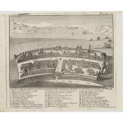
Isoletta Desima abittata Dagli Olandesi nel Giappone..
Bird's-eye view of Deshima copied from a manuscript by Voogt, who was second-in-command on Deshima in 1713. The island is viewed from the landside, depicting the developm...
Date: Venice, 1740
Selling price: ????
Please login to see price!
Sold in 2020
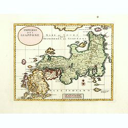
Imperio del Giappone.
Attractive early decorative copper plate map of the Kingdom of Japan with title a nice compass rose.The sea north of Japan is called Mare del Noort o Mare di tramontana d...
Date: Venice, 1740
Selling price: ????
Please login to see price!
Sold in 2017
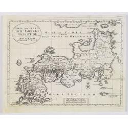
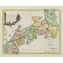
Carta Accurata dell' Imperio del Giappone. . .
Albrizzi published this Italian version of Tirion's map of Japan. In the upper part of the map Jesso of Jesogasima Kamtzchatka is shown north of the Noto Peninsula. At th...
Date: Venice, 1740
Selling price: ????
Please login to see price!
Sold in 2018
Toranga divinité du Japon/ La Pagode de Toranga/ Prédicateur Japonais.
Three scenes on one page showing scenes on the square of a Pagoda, in Japan. Fine copper engraving by Bernard Picart and taken from Bernard Picart's famous Céréonies et...
Date: Amsterdam, 1743
Selling price: ????
Please login to see price!
Sold in 2021
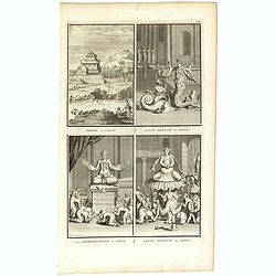
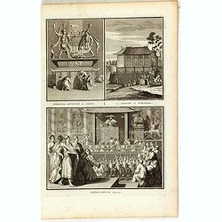
Pagode de Canon/ Canon divinité du Japon/ Autre représentation de Canon/ Xantai divinité du Japon.
Four scenes on one page showing religious scenes, in Japan. Fine copper engraving by Bernard Picart and taken from Bernard Picart's famous Céréonies et costumes religie...
Date: Amsterdam, 1743
Selling price: ????
Please login to see price!
Sold in 2021
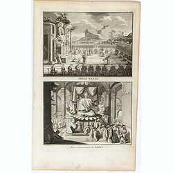
Tiedebaik divinité du Japon. / Amida divinité du Japon. / Autre représentation d'Amida, et diverses manieres de noyer dans son honneur.
Three scenes on one page showing religious scenes, in Japan. Fine copper engraving by Bernard Picart and taken from Bernard Picart's famous Céréonies et costumes religi...
Date: Amsterdam, 1743
Selling price: ????
Please login to see price!
Sold in 2021
Idole Xekia. / Autre représentation de Xekia.
Two scenes on one page showing religious scenes in Japan. Fine copper engraving by Bernard Picart and taken from Bernard Picart's famous Céréonies et costumes religieus...
Date: Amsterdam, 1743
Selling price: ????
Please login to see price!
Sold in 2021
Nieuwe Kaart van t Keizerryk Japan.
Izaak Tirion (d. 1769) Amsterdam publisher. His ' Nieuwe en beknopte handatlas' saw 6 editions between before 1740 and after 1784. Also ' Tegenwoordige staat van alle vol...
Date: Amsterdam, c. 1745
Selling price: ????
Please login to see price!
Sold in 2015
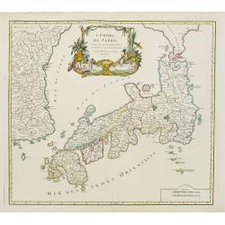
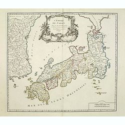
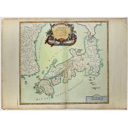
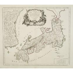
Imperium Japonicum Per Regiones Digestum Sex et Sexaginta Atque Ipsorum Japonensium Mappis Descriptum Ab Hadriano Relando.
Prepared by H.Reland (1676-1718) a professor active in Utrecht and specialized in Asian languages, geography and religions. His first map was a map of Japan copied after ...
Date: Amsterdam, 1745
Selling price: ????
Please login to see price!
Sold
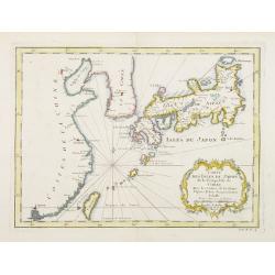
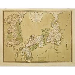
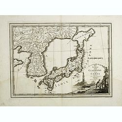
Carte des Isles du Japon et la Presqu'Isle de Coree..
A fine map of the islands of Japan embellished with fine baroque decorations.Bellin influenced other cartographers with his erroneous portrayals of Japan. Included in Ant...
Date: Paris 1746
Selling price: ????
Please login to see price!
Sold
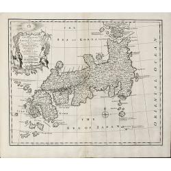
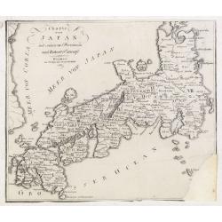
A New and Accurate Map of the Empire of Japan Laid down from the Memoirs of the Portuguese and Dutch and ... the Jesuit Missionaries
Bowen's map of Japan from 'A Complete System of Geography'. With an elaborate allegorical cartouche and a compass rose. The way in which the area to the north of Honshu i...
Date: London, 1747
Selling price: ????
Please login to see price!
Sold in 2011
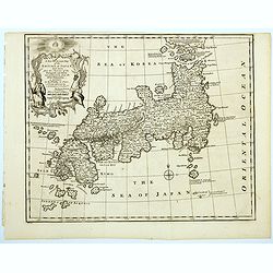
A New And Accurate Map Of The Empire Of Japan, Laid Down from The Memoirs of the Portuguese and Dutch, and particularly from the Jesuit Missionaries.
A beautiful example of Emmanuel Bowen's map of the Empire of Japan. The map clearly identifies Japanese provinces, towns, islands, lakes, mountains, etc. There are a numb...
Date: London, 1747
Selling price: ????
Please login to see price!
Sold in 2023
Carte de L'Empire du Japon.
A fine map of the islands of Japan embellished with fine baroque decorations.Bellin influenced other cartographers with his erroneous portrayals of Japan. This is seen in...
Date: Paris, 1748
Selling price: ????
Please login to see price!
Sold
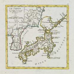
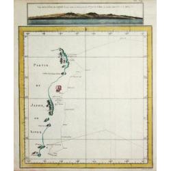
Le Japon.
Fine miniature map in a second state. Major cartographical corrections are the reduction of the size of Terred' Yedso and renaming it Jeso-Gasima , and the addition of fu...
Date: Paris 1749
Selling price: ????
Please login to see price!
Sold
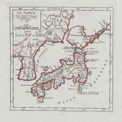
Le Japon.
Small detailed map of Japan and Korea. Dated 1749. A note next to island "Fatsisio ou l'Empereur envoye en exil les Grands".From Atlas Portatif Universel, by Ro...
Date: Paris, later than 1749
Selling price: ????
Please login to see price!
Sold in 2008
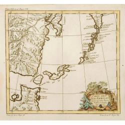
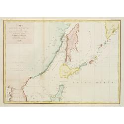
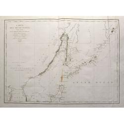
Carte des Isles Kouriles.
A good impression of a detailed, finely engraved map of the north of Honshu. Derived from Russian maps resulting from the expeditions of Bering, Cherikov and others, one ...
Date: Paris 1750
Selling price: ????
Please login to see price!
Sold
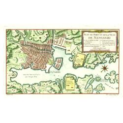
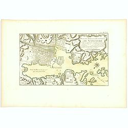
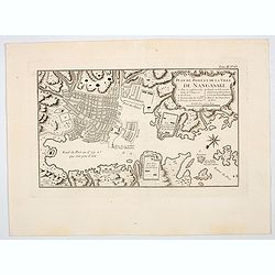
Plan du Port et de la Ville de Nangasaki.
This plan originates from Charlevoix's work Histoire et description Générele du Japon . His first in 1715 published work was the Histoire de l'etablissement du christia...
Date: Paris 1750
Selling price: ????
Please login to see price!
Sold in 2021
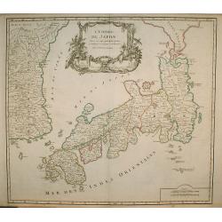
L' Empire Du Japon, divise en sept principales ..
Large map of Japan with a distinctively French style title cartouche containing two small landscapes.The map draws heavily on the previous work of Bellin, but includes a ...
Date: Paris 1750
Selling price: ????
Please login to see price!
Sold
L'Empire du Japon divisé en sept principales parties. . .
Large map of Japan with a distinctively French style title cartouche containing two small landscapes.The map draws heavily on the previous work of Bellin, but includes a ...
Date: Paris, 1750
Selling price: ????
Please login to see price!
Sold in 2011
L'EMPIRE DU JAPON
Large map of Japan with a distinctively French style title cartouche containing two small landscapes.The map draws heavily on the previous work of Bellin, but includes a ...
Date: Paris 1750
Selling price: ????
Please login to see price!
Sold in 2019
Carte de L'Empire du Japon.
A fine map of the islands of Japan embellished with fine baroque decorations.Bellin influenced other cartographers with his erroneous portrayals of Japan. This is seen in...
Date: Paris 1752
Selling price: ????
Please login to see price!
Sold
A New and Accurate Map of the Empire of Japan.
An interesting and detailed English map of the lands of Japan closely modeled on Nicolas Bellin's map of 1735.
Date: London, 1752
Selling price: ????
Please login to see price!
Sold in 2008
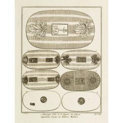
Monnoyes d'Or et d'Argent du Japon. Pl. VII.
Decorative print illustrating Golden and silver coins from Japan. From Histoire générale des voyages..> by Antoine François Prévost.Title in French and Dutch.
Date: Paris, 1752
Selling price: ????
Please login to see price!
Sold
Carte de L'Empire du Japon.
A fine map of the islands of Japan embellished with fine baroque decorations.Bellin influenced other cartographers with his erroneous portrayals of Japan. This is seen in...
Date: Amsterdam, 1752
Selling price: ????
Please login to see price!
Sold in 2008
Carte de L'Empire du Japon.
A fine map of the islands of Japan embellished with fine baroque decorations. Bellin influenced other cartographers with his erroneous portrayals of Japan. This is seen i...
Date: Paris, 1752
Selling price: ????
Please login to see price!
Sold in 2008
Carte de L'Empire du Japon.
A fine map of the islands of Japan embellished with fine baroque decorations.Bellin influenced other cartographers with his erroneous portrayals of Japan. This is seen in...
Date: Paris, 1752
Selling price: ????
Please login to see price!
Sold in 2020
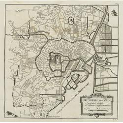
Grundriss von Jedo. . . N°24
City plan of the Emperor\'s Palace and the town of Jedo, Tokyo, Japan with a key to important buildings and bridges. In: Allgemeine Historie der Reisen zur Wasser und zu ...
Date: Leipzig, 1753
Selling price: ????
Please login to see price!
Sold in 2008
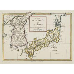
Carte de la Corée et du Japon. Par M.Brion de la Tour Ing.r Geographe du Roi.
Rare map of Japan and Korea prepared by Brion de la Tour.
Date: Paris, 1754
Selling price: ????
Please login to see price!
Sold in 2008
Carte du Japon et de la Corée.
Neat map of Japan, less Hokkaido but including the Korean peninsula, with a large figured cartouche at top center. A note reads to the effect that Le Rouge has simplified...
Date: Paris, 1756
Selling price: ????
Please login to see price!
Sold in 2008
Carte du Japon et de la Corée.
Neat map of Japan, less Hokkaido but including the Korean peninsula, with a large figured cartouche at top centre. A note reads to the effect that Le Rouge has simplified...
Date: Paris 1756
Selling price: ????
Please login to see price!
Sold in 2008
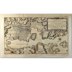
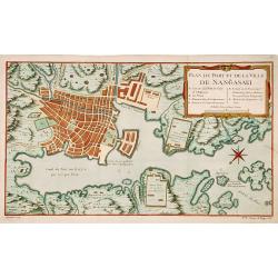
Plan de la Ville et du Port de Nangasaki.
A fine copper engraved map featuring a 'birds-eye' view of Nagasaki, Japan. The map is oriented to the southwest with a bold compass rose. The map locates the principal p...
Date: Paris, 1757
Selling price: ????
Please login to see price!
Sold in 2019
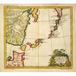
Carte des Isles Kouriles.
An attractive and unusual map of the Kuriles Islands and the northern coast of Hokkaido. The map includes numerous inaccuracies and fanciful names for a number of the isl...
Date: Paris, c. 1760
Selling price: ????
Please login to see price!
Sold in 2020
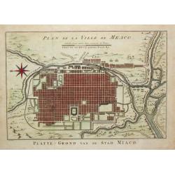
Plan de la Ville de Meaco.
Jaques Nicolas Bellin (1702-720) was the most important French hydrographer of the 18th century. Sea-atlas 'Hydrographique Français' , 1756-65, atlas to accompany Prévo...
Date: Amsterdam, c. 1760
Selling price: ????
Please login to see price!
Sold in 2016
Plan du port et de la ville de Nangasaki.
This plan originates from Charlevoix's work Histoire et description Générele du Japon . His first in 1715 published work was the Histoire de l'etablissement du christia...
Date: Paris, 1760
Selling price: ????
Please login to see price!
Sold in 2023
Plan du port et de la ville de Nangasaki.
Attractive and well detailed plan of Nagasaki, large title cartouche with reference key to principal points of interest. Deshima is central to the map.Jacques Nicolaas Be...
Date: Paris, 1760
Selling price: ????
Please login to see price!
Sold in 2018
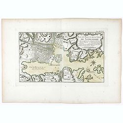
Plan du port et de la ville de Nangasaki.
Attractive and well detailed plan of Nagasaki, large title cartouche with reference key to principal points of interest. Deshima is central to the map.Jacques Nicolaas Be...
Date: Paris, 1760
Selling price: ????
Please login to see price!
Sold in 2020
Plan du port et de la ville de Nangasaki.
An attractive and detailed plan of Nagasaki, with a large title cartouche with a reference key to principal points of interest. Deshima is central to the map.Jacques Nico...
Date: Paris, 1760
Selling price: ????
Please login to see price!
Sold in 2023
Plan de Jedo.
An antique city plan of the city and port of Tokyo, Japan built for the Dutch (VOC - Dutch East India Company) concession, on the Japanese island of Kyushu. Published by ...
Date: Paris, 1764
Selling price: ????
Please login to see price!
Sold in 2020
![[2 maps] Carte des Nouvelles découvertes.. / Extrait d'une Carte Japonaise de l'Univers..](/uploads/cache/23658-250x250.jpg)
[2 maps] Carte des Nouvelles découvertes.. / Extrait d'une Carte Japonaise de l'Univers..
Two maps on one sheet. In both maps there are texts a.o. by Kaempfer who refers to voyages made by Japanese seafarers in that region. The map is from Diderot's Encycloped...
Date: Paris, 1770
Selling price: ????
Please login to see price!
Sold
![Carte des Isles du Japon et la Presqu Isle de Coree ... [Schley]](/uploads/cache/84450-250x250.jpg)
Carte des Isles du Japon et la Presqu Isle de Coree ... [Schley]
Map of Japan and Korea, with Taiwan and Chinese cities: Pekin, Canton and Nankin. From the rarer dutch edition by Schley "Origin: Histoire Générale des voyages, ou...
Date: Amsterdam, ca. 1770
Selling price: ????
Please login to see price!
Sold in 2021
Carte des Isles du Japon.. Coree, Avec .. De la Chine..
Uncommon map of Japan, Korea, Taiwan and the south east coast of China from Peking till Macao. After J.N.Bellin, with title in Dutch in lower margin, engraved by J.van Sc...
Date: Amsterdam 1773
Selling price: ????
Please login to see price!
Sold
Nieuwe en Naukeurige Kaart van het Keizerryk Japan
A rare, fine decorative map of Japan, with the cartouche on the upper left. In a very good state.The map is of interest for the use of East Sea, the sea between Korea and...
Date: Amsterdam, 1774
Selling price: ????
Please login to see price!
Sold in 2014
L'Empire Du Japon Divise En Sept Principales Parties..
Santini's Italian published edition of Giles Didier Robert De Vaugondy's map of Japan first appeared in 1778 in the "Atlas Universel".In 1784 Santini sold the p...
Date: Venice, 1776
Selling price: ????
Please login to see price!
Sold in 2020
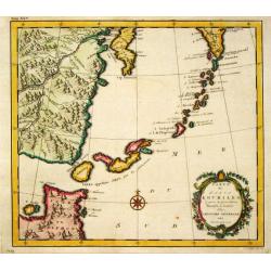
Carte des Isles Kouriles.
An attractive and unusual map of the Kuriles Islands and the northern coast of Hokkaido. The map includes numerous inaccuracies and fanciful names for a number of the isl...
Date: Amsterdam, 1780
Selling price: ????
Please login to see price!
Sold in 2011
Carta dell' Impero Giappone . . .
Map of Japan from the Italian edition of Abbè Presvost’s “Histoire Générale des Voyages”. The Histoire Géneral des Voyages was a monumental eighteenth century g...
Date: Venice, ca. 1781
Selling price: ????
Please login to see price!
Sold in 2020
L'Empire Du Japon Divise En Sept Principales Parties..
Santini's Italian published edition of Giles Didier Robert De Vaugondy's map of Japan first appeared in 1778 in the "Atlas Universel".In 1784 Santini sold the p...
Date: Venice, 1776 - 1784
Selling price: ????
Please login to see price!
Sold in 2008
L'Impero del Giapon diviso in sette principali parti cive..
The map of the Japanese Empire published by Antonio Zatta (1757-97) continued to show most of the inaccuracies of earlier eighteenth-century maps.
Date: Venice 1785
Selling price: ????
Please login to see price!
Sold in 2008
L'Impero del Giapon diviso in sette principali parti cive..
The map of the Japanese Empire published by Antonio Zatta (1757-97) continued to show most of the inaccuracies of earlier eighteenth-century maps.
Date: Venice, 1785
Selling price: ????
Please login to see price!
Sold in 2011
L' Impero del Giapon diviso in sette principali parti cioè Ochio Quanto Jetsegen Jetsen Jamaisoit, Xicoco e Xmo. . .
The map of the Japanese Empire published by Antonio Zatta (1757-97) continued to show most of the inaccuracies of earlier eighteenth-century maps.To the left the tip of S...
Date: Venice, 1785
Selling price: ????
Please login to see price!
Sold in 2015
L' Empire Du Japon, divisé en sept principales . . .
Giles Didier Robert De Vaugondy's map of Japan in a second state, now with the date removed. Published by Charles Francois Delamarche, who acquired De Vaugondy's business...
Date: Paris, c. 1786
Selling price: ????
Please login to see price!
Sold in 2009

Walvischvangst Te Firando in Japan.
A wonderful, rare and early copper engraving of Whaling in Hirado, Nagasaki, Japan. Published in "Nederlandsche Reizen" by Petrus Conradi in 1786.
Date: Amsterdam, 1786
Selling price: ????
Please login to see price!
Sold in 2016
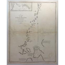
Plan of the Kurile Islands and Lands Little Known. . .
A fine copperplate chart of the Kirile Islands. From La Perouse’s ATLAS DU VOYAGE DE LA PEROUSE. Published by G.G & J. Robinson in London in 1798. Engraved by Neale...
Date: London, 1791
Selling price: ????
Please login to see price!
Sold in 2018
The Empire of Japan divided into seven principal parts and subdivided into sixty-six kingdoms, with the Kingdom of Corea, from Kempfer and the Portuguese.
Detailed map of Japan and Korea prepared by Kaempfer and published in London by Laurie and Whittle, from "New Universal Atlas".The map is of interest for the us...
Date: London, 1794
Selling price: ????
Please login to see price!
Sold in 2010
Gedeelt van Japan of Nipon / Gezigt van de Kust van Japan.
Captain James Cook (1728-79), explorer, circumnavigator and hydrographer. Three voyages, 1768-71, 1772-75 and 1776-79. From 1778 on printed editions of ' Captain Cook's T...
Date: Amsterdam, 1795
Selling price: ????
Please login to see price!
Sold in 2019
Carte des découvertes.. 1787.. Et Manille..
La Pérouse's important large-scale chart of Northern Japan, Hokkaido, the Kuriles and the tip of Korea and Kamschatka.Published in the Atlas volume that accompanied the ...
Date: Paris 1797
Selling price: ????
Please login to see price!
Sold in 2010
Carte des découvertes, faites en 1787 dans les mers de Chine et de Tartarie, par les Fregates Francaises la Boussole et l'Astrolabe, depuis leur depart de Manille jusqu'à leur arrivee au Kamtschatka. 2e. Feuille
Important large sea chart of eastern Russia with a part of Korea, Hokkaido, Sakhalinsk, the Kuril Islands, and the Sea of Okhotsk. Shows the route and dates of the explor...
Date: Paris, 1797
Selling price: ????
Please login to see price!
Sold in 2015
Le Isole del Giappone e la Corea. . .
Japan and Korea, from the "Nuovo Atlante Geografico Universale". With unusual shape of Hokkaido here called "Jeso-Gasima", the semi-mythical island to...
Date: Rome, 1798
Selling price: ????
Please login to see price!
Sold in 2014
Charte von Japan mit seinen VII Provinzen nach Robert's Entw.
A detailed and scarce map of Japan after Gilles Robert. The map is of interest for the double naming of "Meer von Corea" and Meer von Japan.", the sea betw...
Date: Weimar, 1811
Selling price: ????
Please login to see price!
Sold in 2015
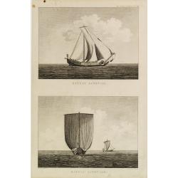
Bateau Japonais. Two prints on one sheet.
Engraving of 18th century Japanese boat drawn by Lt. Blondela. Done during the expedition of comte de Jean-Francois de Galaup La Perouse in the Pacific Ocean in 1785-1788...
Date: Paris, 1812
Selling price: ????
Please login to see price!
Sold in 2023
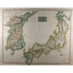
Corea and Japan.
A fine large-scale map of Japan and Korea showing an increasingly refined outline to the Japanese islands but still oversized Korean peninsula. The map appeared in Thomso...
Date: Edinburgh, 1815
Selling price: ????
Please login to see price!
Sold in 2010
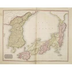
Japan.
This is an extremely fine mapping of Japan and Korea from the scarce American edition of Pinkerton's Modern Atlas, published by Thomas Dobson & Co. of Philadelphia in...
Date: Philadelphia, 1818
Selling price: ????
Please login to see price!
Sold in 2010
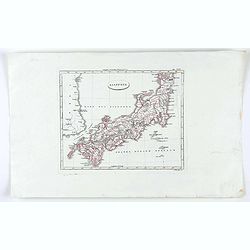
Giappone.
Map of Japan from "Relazione: 'fa parte di:' Nuovo atlante di geografia universale in 52 carte" by Luigo Rossi.
Date: Milan, 1821
Selling price: ????
Please login to see price!
Sold in 2020
