Browse Listings in Asia > Japan > Kuril islands
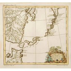
Carte des Isles Kouriles.
A good impression of a detailed, finely engraved map of the north of Honshu. Derived from Russian maps resulting from the expeditions of Bering, Cherikov and others, one ...
Date: Paris 1750
Selling price: ????
Please login to see price!
Sold
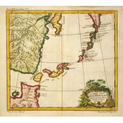
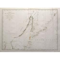
Carte des Isles Kouriles.
An attractive and unusual map of the Kuriles Islands and the northern coast of Hokkaido. The map includes numerous inaccuracies and fanciful names for a number of the isl...
Date: Paris, c. 1760
Selling price: ????
Please login to see price!
Sold in 2020
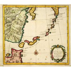
Carte des Isles Kouriles.
An attractive and unusual map of the Kuriles Islands and the northern coast of Hokkaido. The map includes numerous inaccuracies and fanciful names for a number of the isl...
Date: Amsterdam, 1780
Selling price: ????
Please login to see price!
Sold in 2011
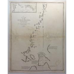
Plan of the Kurile Islands and Lands Little Known. . .
A fine copperplate chart of the Kirile Islands. From La Perouse’s ATLAS DU VOYAGE DE LA PEROUSE. Published by G.G & J. Robinson in London in 1798. Engraved by Neale...
Date: London, 1791
Selling price: ????
Please login to see price!
Sold in 2018
Carte des découvertes, faites en 1787 dans les mers de Chine et de Tartarie, par les Fregates Francaises la Boussole et l'Astrolabe, depuis leur depart de Manille jusqu'à leur arrivee au Kamtschatka. 2e. Feuille
Important large sea chart of eastern Russia with a part of Korea, Hokkaido, Sakhalinsk, the Kuril Islands, and the Sea of Okhotsk. Shows the route and dates of the explor...
Date: Paris, 1797
Selling price: ????
Please login to see price!
Sold in 2015
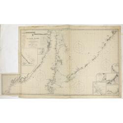
Japan - The Kuril Islands from Nipon to Kamchatka..
Large chart representing the Kuril Islands in the Pacific Ocean. Some of the capes and bays are highlighted in red and yellow.Contains 7 inset plans of bays, anchorages a...
Date: London, 1893, updated 1895
Selling price: ????
Please login to see price!
Sold in 2021
