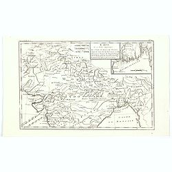
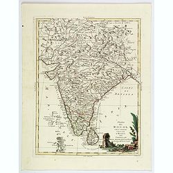
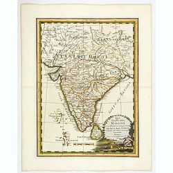
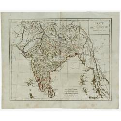
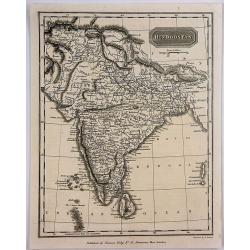
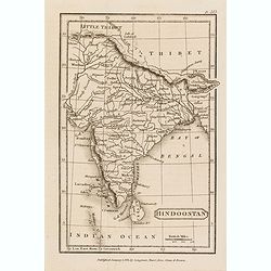
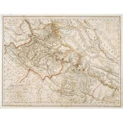
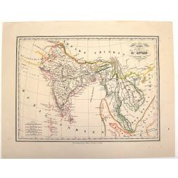
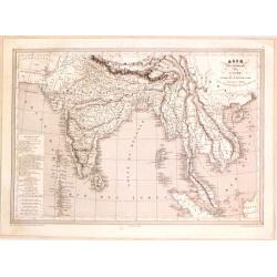
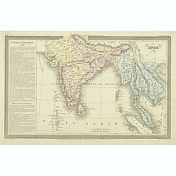
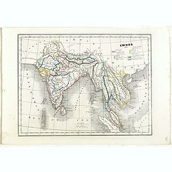
Carte de la Partie Superieure de L'Indie en de ca du Gange. . .
Rigobert Bonne (1727-1795), French cartographer. His maps are found in the 'Atlas Moderne' (1762), Raynal's 'Histoire Philos. du Commerce des Indes' (1774) and 'Atlas Enc...
Date: Paris, 1780
Selling price: ????
Please login to see price!
Sold in 2020
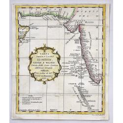
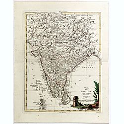
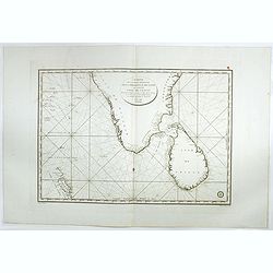
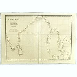
Carta Della Costa di Persia, Guzarat, E Malabar.
A copper engraving by Bellin on the order of Conte Di Maurepas, dated 1781. Published in the Italian edition of the atlas. This interesting map shows a tip of the Arabian...
Date: Paris, 1781
Selling price: ????
Please login to see price!
Sold in 2018
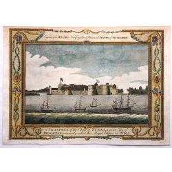
A Prospect of the Castle of Surat, a Great City of Indostan, Commonly called the Mogul Empire in India.
Striking Engraving of the Castle of Surat by John Goldar (1729-1795) for Millar's New Complete and Universal System of Geography dated 1782. The print has a very fancy bo...
Date: London, 1782
Selling price: ????
Please login to see price!
Sold in 2017
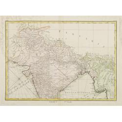
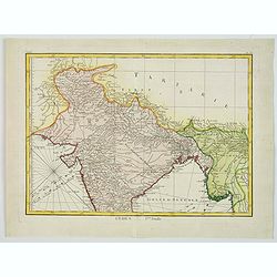
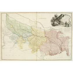
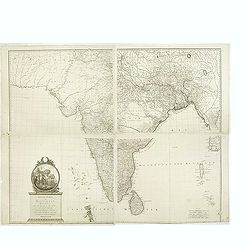
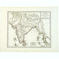
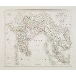
Indes. Iere. Feuille.
Attractive map of the northern part of India, extending northwards to Pakistan and Afghanistan. Including Bangladesh in the East. Boundaries outlined in hand color.From t...
Date: Paris, ca 1783
Selling price: ????
Please login to see price!
Sold in 2010
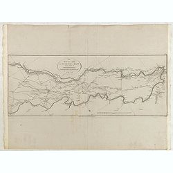
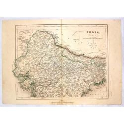
The Doo=AB, from Allahabad to Kalpy. .
Detailed map of part of the rivers Ganges and Jumnah.From the English original edition published in London in 1783 by Brown under the title "Memoir of a Map of Hindu...
Date: Londen, 1783
Selling price: ????
Please login to see price!
Sold in 2015
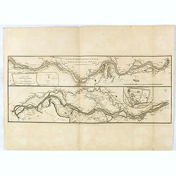
The river Ganges from Patna to Surdah . . .
Detailed map of part of the rivers Ganges and Jumnah.From the English original edition published in London in 1783 by Brown under the title "Memoir of a Map of Hindu...
Date: Londen, 1783
Selling price: ????
Please login to see price!
Sold in 2016
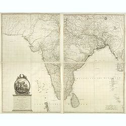
Indes. Iere. Feuille.
An attractive map of the northern part of India, extending northwards to Pakistan and Afghanistan, and it includes Bangladesh in the East. Boundaries outlined in hand col...
Date: Paris, ca 1783
Selling price: ????
Please login to see price!
Sold in 2020
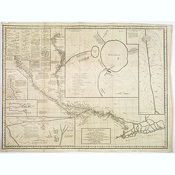
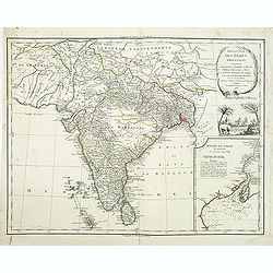
Carte Generale du Cours du Gange et du Gagra. . .
A large chart with six inset maps printed on one sheet by the Jesuit Joseph Tiefentaller in the latter half of the eighteenth century. The map is in French and in Persian...
Date: Paris ca 1784
Selling price: ????
Please login to see price!
Sold in 2023
Stato del Mogol con l' Isole di Ceilan e Maldive.
A handsome map of India including Sri Lanka and the Maldives islands.
Date: Venice, 1785
Selling price: ????
Please login to see price!
Sold in 2018
Stato del Mogol con l' Isole di Ceilan e Maldive.
A handsome map of India including Sri Lanka and the Maldives islands. With a nice decorative title cartouche in lower right corner. This lovely map incorporates plenty of...
Date: Venice, 1785
Selling price: ????
Please login to see price!
Sold in 2019
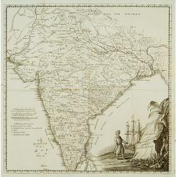
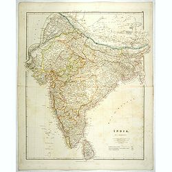
A Map of Bengal, Bahar, Oude and Allahabad with Part of Agra and Delhi Exhibiting the Course of the Ganges from Hurdwar to the Sea..
Very large wall map extending from the Bay of Bengal in the South East as far as Tibet to the North and Gohud to the West.Engraved from the original drawing in the posses...
Date: London, 1786
Selling price: ????
Please login to see price!
Sold in 2022
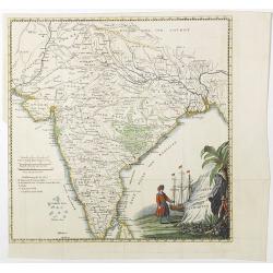
Presqu'Isle Des Indes Orientales, Comprenant l'Indostan ou l'Empire du Mogol. . .
Detailed map of India with inset map (220x155mm) of the mouth of the river Ganges. Identifies Delhi (or Jehan Abad), Agra (or Ekbar Abad), Bombay, Goa, Calcutta, Pondiche...
Date: Paris, Boudet, 1786
Selling price: ????
Please login to see price!
Sold in 2016
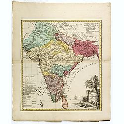
Neueste Karte von Hindostan, Bengalen etc. . .
Wall map of the Indian sub-continent after James Rennell, with large title cartouche of Britannia, native figures, a soldier and a merchant. Published by F. A. Schraembl ...
Date: Vienna, 1788
Selling price: ????
Please login to see price!
Sold
Neueste Karte von Hindostan, Bengalen etc. . .
Wall map of the Indian sub-continent after James Rennell, with large title cartouche of Britannia, native figures, a soldier and a merchant. Published by F. A. Schraembl...
Date: Vienna, 1788
Selling price: ????
Please login to see price!
Sold in 2019
Presqu 'Isle Des Indes Orientales,..
Detailed map of India with inset map (220x155mm) of the entree of the river Ganges. With decorative scene with an elephant underneath the title cartouche.
Date: Paris, 1790
Selling price: ????
Please login to see price!
Sold in 2012
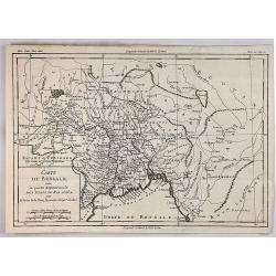
Carte du Bengale avec la Partie Septentrionale des Etats du Roi D'Aua.
A detailed eighteenth century map of Bengal, India with Calcutta prominently marked, and the Ganges up to Patna, and that part which is modern Bangladesh. From Brunet's '...
Date: Paris, 1790
Selling price: ????
Please login to see price!
Sold in 2019
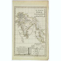
Ad Antiquam Indiae Geographiam Tabula.
A map of the ancient map of the Indian subcontinent, with an inset of Taprobana (Ceylon / Sri Lanka), next to a set of mileage scales, in the shape of a slab of rock. Pla...
Date: Anon, ca 1790
Selling price: ????
Please login to see price!
Sold in 2020
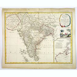
Presqu 'Isle Des Indes Orientales. . .
A nice large and detailed map of India by de Vaugondy with inset map of the entree of the river Ganges.
Date: Paris, 1790
Selling price: ????
Please login to see price!
Sold in 2018
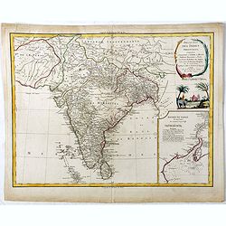
Presqu 'Isle Des Indes Orientales. . .
A nice large and detailed map of India by de Vaugondy with inset map of the entree of the river Ganges. With a decorative scene with an elephant underneath the title cart...
Date: Paris, 1790
Selling price: ????
Please login to see price!
Sold in 2019
Stato del Mogol con le Coste del Malabar..
Fine map of India including Ceylon.
Date: Venice 1791
Selling price: ????
Please login to see price!
Sold
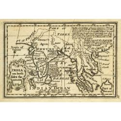
India on both Sides the Ganges.
Uncommon miniature map from Gibson's "Atlas Minimus, or a New Set of Pocket Maps of the several Empires, Kingdoms and States of the known World".
Date: London, 1792
Selling price: ????
Please login to see price!
Sold in 2011
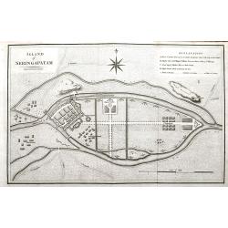
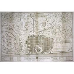
Island of Seringapatam.
A scarce map of Srirangapatna, (also Shrirangapattana) in Mandya district of the Indian state of Karnataka. Located near the city of Mysore. The entire town is enclosed b...
Date: London, ca. 1792
Selling price: ????
Please login to see price!
Sold in 2022
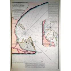
A Sketch of Coringa Bay...
RARE nautical from "The country East-India Pilot" published in 1799 by Laurie & Whittle. Engraved by Neele, after Capt. Lesley 1774. Great copper engraved...
Date: London, 1794
Selling price: ????
Please login to see price!
Sold in 2011
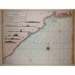
The coast of India, from Point Gordeware to the Ganges comprehending part of the coast of Golconda the coasts of Orissa and Bengal, with the mouth of the Hoogly river
SCARCE sea from "The country East-India Pilot" published in 1799 by Laurie & Whittle. The copper engraved map extends from the Coringa Bay to the Ganges r...
Date: London, 1794
Selling price: ????
Please login to see price!
Sold in 2011
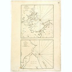
The Bay of Tricoenmale or Trinkili-Male, on the East Coast of Ceylon. (together with) Plan of Venlos Bay, on the East Coast of Ceylon.
Nautical chart of the Tricoenmale or Trinkili-Male (Trincomalee) Bay and the Venlos (Vandelous) Bay on the east coast of Sri Lanka or Ceylon.Two charts on a single sheet,...
Date: London, 1794
Selling price: ????
Please login to see price!
Sold in 2016
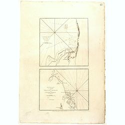
Calpentyn Road, on the West Coast of Ceylon. The East Coast of Ceylon, from Venlos Bay to Batecalo, with the Banks, Rocks, Soundings & ca.
Two nautical charts on one sheets, originally prepared by the Dutch publisher Van Keulen. The upper chart of Calpentyn Road, on the West Coast of Ceylon. (255x257mm.)The ...
Date: London, 1794
Selling price: ????
Please login to see price!
Sold in 2020
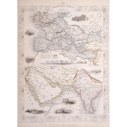
India Antiqua, auctore D'Anville...
Large scale map of India and Siam, extending to the Strait of Malacca and the area of today's Singapore. With several place names, rivers, islands, and mountain ranges sh...
Date: London, c1795
Selling price: ????
Please login to see price!
Sold in 2016
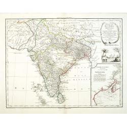
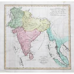
Gli Stati del Mogol e la Penisola delle Indie di qua dal Gange.
Cassini's lovely map of the Mogol States in India, published in: Nuovo atlante geografico universale delineato sulle ultime osservazioni in Rome. As well as a strong, dec...
Date: Rome, 1797
Selling price: ????
Please login to see price!
Sold in 2018
Gli Stati del Mogol e la Penisola delle Indie di qua dal Gange.
Cassini's large and lovely map of the Mogul States of India, published in: Nuovo atlante geografico universale in Rome. As well as a strong, decorative title cartouche, t...
Date: Rome, 1797
Selling price: ????
Please login to see price!
Sold in 2019
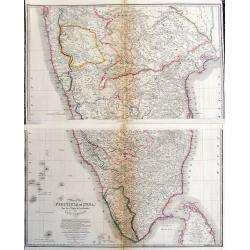
Carte de la partie Méridionale dela presque'isle de L'Inde qui comprend L'Isle de Ceylan. . . 1798.
Large focused on southern part of India and Sri Lanka. Showing villages, banks, isles and soundings made in meters.Chart was prepared by Vice Admiral Rosili and publishe...
Date: Paris, after 1798
Selling price: ????
Please login to see price!
Sold in 2017
Inde Ancienne.
Map of ancient India in attractive out-line color. Shows from modern day Pakistan eastwards and southwards down to Thailand, the Nicobar and the Andaman Islands, includes...
Date: Paris, 1799
Selling price: ????
Please login to see price!
Sold in 2017
Charte von Indostan.
Rare map of India, with imposing title cartouche lower right. Engraved by Gustav Georg Endner (1754-1824).
Date: Leipzig 1800
Selling price: ????
Please login to see price!
Sold
PLAN DE LA VILLE DE PONDICHERI DEDIÉ A LA MÉMOIRE DE Mr. DUPLEIX...
Very large and unusual plan of the city of Pondichéry in India. The map depicts the famous hold-off of the British Navy by Dupleix during the siege in 1748. Large scale ...
Date: Paris, ca.1800
Selling price: ????
Please login to see price!
Sold in 2009
Charte von Indostan.
Rare map of India, with imposing title cartouche lower right. Engraved by Gustav Georg Endner (1754-1824).
Date: Leipzig, 1800
Selling price: ????
Please login to see price!
Sold in 2018
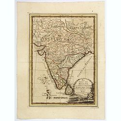
Carte de L'Inde.
A scarce engraved map of the Indian subcontinent covering India and including parts of Iran (Perse), Afghanistan (Royaume de Candahar), Tibet, China, and Indochina (Empir...
Date: Paris, 1803
Selling price: ????
Please login to see price!
Sold in 2021
Charte von OstIndien nach I.Rennel von Gebr. Lotter.
Decorative map in very good condition with a title cartouche at bottom right, scale bars at the top right, bottom left color key legend.A rare map published by After a ma...
Date: Augsburg, 1777/1810
Selling price: ????
Please login to see price!
Sold
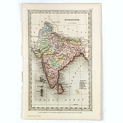
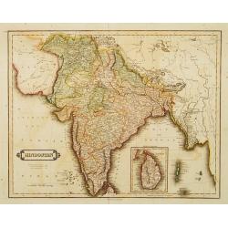
Hindoostan.
A fine copper engraved map of Hindoostan (now India) drawn and engraved by Alexander Findlay and published by Thomas Kelly, London in 1814
Date: London, 1814
Selling price: ????
Please login to see price!
Sold in 2017
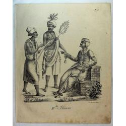
Group From India (111 ter Stamm).
A group of three men from India. From a natural history or ethnographic folio by renowned Swiss artist and lithographer Carl (Karl) Joseph Brodtmann (1787-1862).Carl Jose...
Date: Zurich, 1816
Selling price: ????
Please login to see price!
Sold in 2019
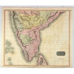
Southern Hindostan.
A fine Thomson regional map of India, extending from Arungabad, Mahoor and Cicacole in the North, to the southern tip of India, including most of Celyon. Highly detailed,...
Date: Edinbourgh, 1817
Selling price: ????
Please login to see price!
Sold in 2021
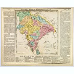
Hindoostan or India.
A fascinating 'Geographical, Historical and Statistical Map of India'. The map indicates 'British Possessions or Dependencies', and identifies 'A Place remarkable for a B...
Date: Philadelphia, 1821
Selling price: ????
Please login to see price!
Sold in 2019
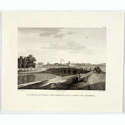
Madras, Entrée Occidentale du Fort St. George.
An attractive copperplate engraving of the east entrance to the St. George Fort in Madras (Chennai) in southern India. You can see an impressive wall surrounding the fort...
Date: Anon, ca 1821
Selling price: ????
Please login to see price!
Sold in 2020
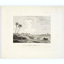
Vue du Fort St. George a Madras prise a l'est.
A nice copperplate view of Madras from the south east, engraved after the Daniell aquatint from his book Oriental Scenery, or Views of the Architecture, Antiquities and L...
Date: Paris ca 1821
Selling price: ????
Please login to see price!
Sold in 2019
Hindoostan.
Somewhat later but very finely engraved and detailed map of India. Tibet is left blank. Published by Longman, Hurst, Rees, Orne & Brown, a London publishing company b...
Date: London, 1823
Selling price: ????
Please login to see price!
Sold in 2015
Hindoostan.
Somewhat later but very finely engraved and detailed map of India. Tibet is left blank. Published for the proprietors by Mr.Bull Holles St.Cavendish Square. Printed by Pe...
Date: London, 1823
Selling price: ????
Please login to see price!
Sold in 2017
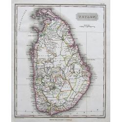
Ceylon.
A fine and richly detailed map of Sri Lanka. With numerous place names. Drawn by A. Arrowsmith, engraved by Sidney Hall, and published by Archibald Constable & Co., i...
Date: Edinburgh, 1823
Selling price: ????
Please login to see price!
Sold in 2017
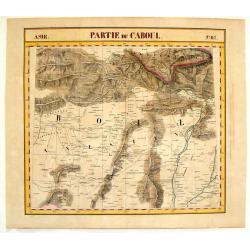
Partie du Caboul - No. 67.
Detailed map of portions of Afghanistan and Pakistan, including Caboul. Lithographed by H. Ode. One of 387 maps of the world produced on the same scale. This map was impo...
Date: Brusselles, 1827
Selling price: ????
Please login to see price!
Sold in 2016
![[ LXIII. Varj guiochi].](/uploads/cache/34994-250x250.jpg)
[ LXIII. Varj guiochi].
Aquatint depicting performing arts at a square engraved by G. Bigatti. Plate N°63.From Giulio Ferrario's work Le Costume Ancien et Moderne ou Histoire du gouvernement, de...
Date: Milan, 1827
Selling price: ????
Please login to see price!
Sold in 2018
![[ I. Stromenti musicali].](/uploads/cache/34995-250x250.jpg)
[ I. Stromenti musicali].
Aquatint depicting a group of musicians engraved by G. Zancon. Plate N°50.From Giulio Ferrario's work Le Costume Ancien et Moderne ou Histoire du gouvernement, de la mili...
Date: Milan, 1827
Selling price: ????
Please login to see price!
Sold in 2018
![[ XXV. Festa di Mariatal].](/uploads/cache/34996-250x250.jpg)
[ XXV. Festa di Mariatal].
Aquatint depicting a wedding party engraved by G. Zancon. Plate N°25.From Giulio Ferrario's work Le Costume Ancien et Moderne ou Histoire du gouvernement, de la milice, d...
Date: Milan, 1827
Selling price: ????
Please login to see price!
Sold in 2018
![[ LI. Danza delle Ram-genye ossiano ballerine].](/uploads/cache/34998-250x250.jpg)
[ LI. Danza delle Ram-genye ossiano ballerine].
Aquatint depicting a scene of music and Indian dancers, engraved by G. Zancon. Plate N°51.From Giulio Ferrario's work Le Costume Ancien et Moderne ou Histoire du gouverne...
Date: Milan, 1827
Selling price: ????
Please login to see price!
Sold in 2014
Inde en-deça et au-dela du Gange. . .
Detailed map of India and the Malayan Peninsula, prepared by A. H. Basset, rue Saint-Jacques, no. 64, Paris and published in Atlas classique et Universel de Géographie . ...
Date: Paris, A.H. Basset, 1828
Selling price: ????
Please login to see price!
Sold in 2015
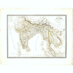
Carte de l'Inde en deça et au-delà du Gange . . .
Very detailed map of India and Sri Lanka, Thailand, Cambodia, Malaysian Peninsular, including Singapore.From his "Atlas Universel".
Date: Paris, Emery Fruger & Co., 1829
Selling price: ????
Please login to see price!
Sold in 2018
![[Manuscript map without title] Map of the east Indian coast with Sri Lanka showing The Cousins Voyage 1831.](/uploads/cache/34583-250x250.jpg)
[Manuscript map without title] Map of the east Indian coast with Sri Lanka showing The Cousins Voyage 1831.
Manuscript map of the Indian coast with Ceylon (Sri Lanka) with the track of the vessel "Le Cousin" from Calcutta to Pondicherry and the retour voyage from Madr...
Date: Perhaps India, ca. 1831
Selling price: ????
Please login to see price!
Sold in 2014
![[Set of 9 maps of India]](/uploads/cache/20230514_144931-250x250.jpg)
[Set of 9 maps of India]
A set of 9 steel engraved maps of India published under the superintendence of the Society for the Diffusion of Useful Knowledge (SDUK), most sheets are early editions da...
Date: London, ca. 1831
Selling price: ????
Please login to see price!
Sold in 2023
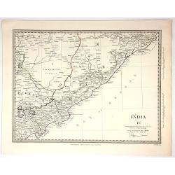
India IV.
Original map engraved by J&C Walker in London and Published by Chapman & Hall in 1832. Published under the Superintendence of the Society for the Diffusion of Use...
Date: London, 1832
Selling price: ????
Please login to see price!
Sold in 2018
Das Himálaja Gebirg in Bissahir, Gherwal..
Very detailed map of Himalaya, plateaus of Tibet and the lowlands of Hindostan, prepared by J.L.Grim and Carl Ritter. In upper high land corner key to travels by Raper 18...
Date: Berlin 1833
Selling price: ????
Please login to see price!
Sold
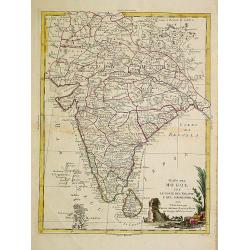
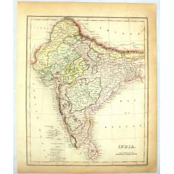
Hindostan.
Uncommon detailed steel engraved map of India, with inset map of Shri Lanka. Published in Edinburgh by D. Lizars.
Date: Edinburgh, 1833
Selling price: ????
Please login to see price!
Sold in 2012
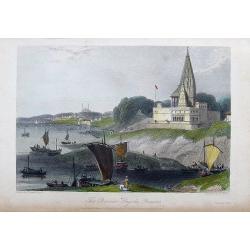
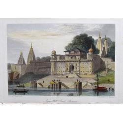
The Bernar Pagoda. Benares.
A fine and detailed view with decorative coloring. Varanasi, also known as Benares, Banaras or Kashi, is a city on the banks of the Ganges in the Uttar Pradesh state of N...
Date: London, 1834
Selling price: ????
Please login to see price!
Sold in 2017
Shuwallah Gaut, Benares.
A fine and detailed view of Shivala Ghat at Benares (Varanasi), a city on the banks of the Ganges in the Uttar Pradesh state of North India. Drawn by William Daniell, and...
Date: London, ca. 1834
Selling price: ????
Please login to see price!
Sold in 2017
Vorder-Indien oder dasIndo-Britische Reich.
This is a nice example of Stieler's 1834 map of the Indian subcontinent. It covers from the Tibet and the Himalayas in the north as far south as Ceylon (Sri Lanka), and f...
Date: Gotha, 1834
Selling price: ????
Please login to see price!
Sold in 2020
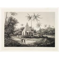
Tombeau d'une Bramine brulée sur le bucher de son mari.
Depiction of an Indian temple after Barthelemy Lauvergne (1805-1875) and engraved in aquatint technique by Sigismond Himely (1801-1872). Published as plate 13 in Voyage a...
Date: Paris, Finot, 1835
Selling price: ????
Please login to see price!
Sold in 2014
![Ostindien [and] Carte de L'Inde. [2 maps]](/uploads/cache/40043-250x250.jpg)
Ostindien [and] Carte de L'Inde. [2 maps]
First map is 'Ostindien' by Radefeld, from Meyer's Atlas, countries and regional boundaries shown in differing colors, with plenty of map detail, relief shown in hachures...
Date: Hildeburghausen, Paris ca. 1835
Selling price: ????
Please login to see price!
Sold in 2017
Map of India..
Very detailed map of India. In the Indian Ocean and the Bay of Bengalen numerous information: Native states not under British protection, Native states under British prot...
Date: London 1836
Selling price: ????
Please login to see price!
Sold
Carte de L'Inde.
An interesting lithographed map of India and Indo China from the Brussels edition of Malte-Brun's "Atlas Complet". The different provinces are nicely differenti...
Date: Brusselles, 1836
Selling price: ????
Please login to see price!
Sold in 2015
India.
colorful map of India engraved by J. Dower in 1836. Published by Orr & company in London.
Date: London, 1836
Selling price: ????
Please login to see price!
Sold in 2014
India (Northern Part).
Detailed colored map of Northern India by J. Archer. Published in London by H.G. Collins in 1836.
Date: London, 1836
Selling price: ????
Please login to see price!
Sold in 2014
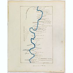
NINGTHEE RIVER, FROM MULPHOO TO SUNAYACHIL.
Finely executed pen drawing in brown ink with river in blue color of The Eastern Frontier Of India. Scale is in English miles. Underneath the title an explanation.From th...
Date: ca, 1836
Selling price: ????
Please login to see price!
Sold in 2017
Asie Meridionale Comprenant L'Inde en deca et au Dela du Gange.
Detailed map of Asia including India. Published by Aubree Armand in Paris in 1837. Engraved by I. Grenier and printed by Mangeon.
Date: Paris, 1837
Selling price: ????
Please login to see price!
Sold in 2015
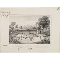
Vue d'un grand étang Indien, au moment des ablutions Carnate. (Inde)
After a drawing by Charles Bélanger. Charles Bélanger (1805-1881), French naturalist and explorer in Asia and the East Indies. Lithography taken most probably from 7 volu...
Date: Paris, ca 1834-1838
Selling price: ????
Please login to see price!
Sold in 2013
India.
Detailed map of India and Ceylon. This map by the nephew of Aaron Arrowsmith first appeared in 1832 and was reissued several times. The present issue appeared in Arrowsmi...
Date: London, 1838
Selling price: ????
Please login to see price!
Sold
Map of the Peninsula of India, from the 19th Degree of North Latitude to Cape Comorin.
Large and detailed map of Southern India from Bomba/Mumbai and Aurangabad, until a part of of Sri Lanka/Ceylon. Original outline color indicated the British Possessions, ...
Date: London, 1838
Selling price: ????
Please login to see price!
Sold in 2017
Carte du Golfe du bengale dressée par Mr daussy, ingénieur hydrographe en chef, d'après les travaux les plus récents. . .
Large sea chart showing the Gulf of Bengal with India, Ceylon and Thailand with the Gulf of Siam to the right. The chart was engraved by E. Collin and Chassant for the Dé...
Date: Paris, 1839
Selling price: ????
Please login to see price!
Sold in 2020
Inde.
Finely engraved map of India, Thailand, Malaysia, including Singapore prepared by A.H.Dufour and engraved by Giraldon-Bovinet. Published by Jules Renouard in his uncommon...
Date: Paris, Jules Renouard, ca.1840
Selling price: ????
Please login to see price!
Sold in 2015
(Manuscript) Plan du port de Bombay.
French manuscript map of Bombay harbor complete with anchorage point at Bombay. The map is likely based on Jean B.N.D. D'Apres de Mannevillette: "Plan du Port de Bom...
Date: France or India, c. 1840
Selling price: ????
Please login to see price!
Sold in 2015
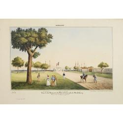
Pondichery - Vue de la Maison du Port et de la rade de Pondichery. . .
Lithography representing a view of Pondicherry. Plate 9. From Souvenirs d'un voyage dans l'Inde, execute de 1834 à 1839, after a design by A. Delessert. Adolphe Delessert...
Date: Paris, 1843
Selling price: ????
Please login to see price!
Sold

Madras. - Scottch - Church.
Lithography representing a view of a Scottish church in Madras. Plate N 13. From Souvenirs d'un voyage dans l'Inde, execute de 1834 a 1839, by A. Delessert.Adolphe Deless...
Date: Paris, 1843
Selling price: ????
Please login to see price!
Sold
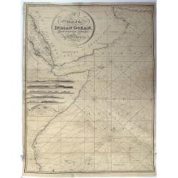
A Chart Of The Indian Ocean Drawn From The Best Authorities.
This detailed sea chart by John William Norie features the Western Indian Ocean and east coast of Africa, from Cape Delgado in the south to Persian Gulf in the north. T...
Date: London, 1844
Selling price: ????
Please login to see price!
Sold in 2015
Indes.
Detailed map of India, Malaysia, Cambodia, Tibet and Thailand, prepared by Charles V. Monin (fl.1830-1880) a French cartographer of Caen and Paris. Published in Atlas Uni...
Date: Paris, 1845
Selling price: ????
Please login to see price!
Sold in 2024
Overland Route to India.
Steel engraved map of the Overland Route to India. The illustrations are by H Warren and engraved by J H Kernot, the map engraved by J Rapkin. Published by John Tallis. T...
Date: London, 1850
Selling price: ????
Please login to see price!
Sold in 2014
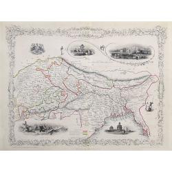
Northern India
A very decorative steel-engraved map of a portion of India including Nepal, Bhutan, and modern day Bangladesh. Very detailed with place names, rivers, hills, bays, lakes,...
Date: London, ca.1850
Selling price: ????
Please login to see price!
Sold in 2017
