Browse Listings in Asia > India > Sri Lanka (Ceylon)
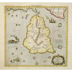
![Taprobana Ins. Tabula XII Asiae. [Sri Lanka.]](/uploads/cache/35395-250x250.jpg)
Taprobana Ins. Tabula XII Asiae. [Sri Lanka.]
Ptolemy's mythical island of Taprobana originally became associated with Sri Lanka although it was sometimes confused with Sumatra. Taprobana, as it was called on most ea...
Date: Lyons, M. Servetus, 1535
Selling price: ????
Please login to see price!
Sold in 2016
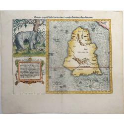
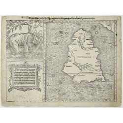
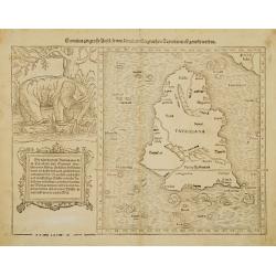
Sumatra ein grosse Insel, so von den alten Geographen Taprobana, ist genent worden (Sri Lanka).
One of the earliest and highly decorative woodcut maps of Ceylon (Sri Lanka) by Sebastian Münster. To the left of the map a cartouche with explanatory text in 10 lines ab...
Date: Basel, ca 1540
Selling price: ????
Please login to see price!
Sold in 2019
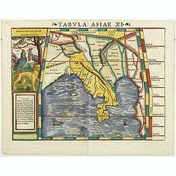
Tabula Asiae XI.
Attractive early woodblock map of South East Asia, with inset panel of tiger, cockerels and parrot. Woodcut map with full hand-coloring as known to Ptolemy. From his Geog...
Date: Basle, H. Petri, c. 1542
Selling price: ????
Please login to see price!
Sold in 2011
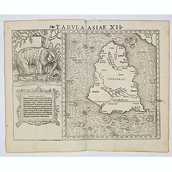
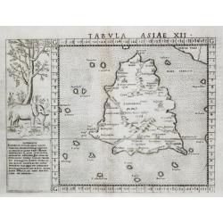
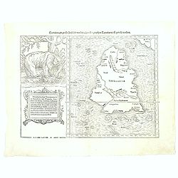
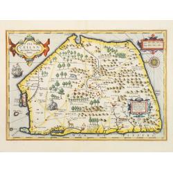
Tabula Asiae XII (Sri Lanka, with Elephant)
The FIRST edition of Munster's first modern map of Sri Lanka, which appeared in his "Geographia Universalis", first published in 1540. The Geographia was a new ...
Date: Basel, Heinrich Petri, 1545
Selling price: ????
Please login to see price!
Sold in 2014
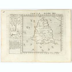
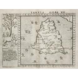
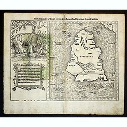
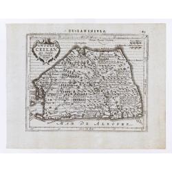
Tabula Asiae XII. (Taprobana)
Scarce FIRST edition of this map depicting the island of Ceylon (Taprobana), based on Gastaldi's 1548 map. An elephant with descriptive text next to the map.Ptolemy's myt...
Date: Venice, 1561
Selling price: ????
Please login to see price!
Sold in 2023
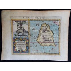
Tabvla Asiae XII.
[Antique map of Sri Lanka] Tabvla Asiae XII. An elegantly engraved early map of Sri Lanka, (misshapen) with left the image of an elephant.
Date: Venice, 1561
Selling price: ????
Please login to see price!
Sold in 2020
![Taprobana [Ceylon/Sri Lanka].](/uploads/cache/84457-250x250.jpg)
Taprobana [Ceylon/Sri Lanka].
Ptolemy's mythical island of Taprobana originally became associated with Sri Lanka. Later, as this theory was discredited, Sumatra became the next candidate. Almost a dec...
Date: Basle, 1561
Selling price: ????
Please login to see price!
Sold in 2020
Tabvla Asiae XII.
An elegantly engraved early map of Sri Lanka, with left the image of an elephant. Ref.: Paranavitana, maps of Dutch Ceylon, p.7.
Date: Venice, 1561
Selling price: ????
Please login to see price!
Sold
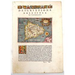
Descrittione del l'Isola di Taprobana.
Charming map of the island of Sri Lanka (Celon). The map is oriented with north to the right. Fancy strapwork cartouche with two faces and a unique compass rose. Printed ...
Date: Venice, 1572
Selling price: ????
Please login to see price!
Sold in 2013
Sumatra ein grosse Insel, so von den alten Geographen Taprobana, ist genent worden (Sri Lanka).
A nice impression of this great map of island of Tabrobana, which was variously thought to be Ceylon or Sumatra. This map depicts Ceylon with the typical misconceptions o...
Date: Basle, 1574
Selling price: ????
Please login to see price!
Sold in 2021
![Tabula Asiae XII [Sri Lanka -- with Elephant]](/uploads/cache/00684-250x250.jpg)
Tabula Asiae XII [Sri Lanka -- with Elephant]
Attractive woodblock map, depicting Sri Lanka as known to Ptolemy. Left of the map a large elephant with descriptive text identifies the island of Taprobana with Sumatra ...
Date: Basle, 1580
Selling price: ????
Please login to see price!
Sold in 2017
Sumatra ein grosse Insel..
A nice impression of this great map of island of Tabrobana, which was variously thought to be Ceylon or Sumatra.This map depicts Ceylon with the typical misconceptions of...
Date: Basle 1580
Selling price: ????
Please login to see price!
Sold
Sumatra Ein Grosse Insel / So Von Den alten Geographen Taprobana...
A fine map of what is regarded as the island of Sri Lanka, by the early, important, and influential German cartographer, Sebastian Munster. The map title, in old German s...
Date: Basle ca. 1550 - 1580
Selling price: ????
Please login to see price!
Sold in 2016
Sumatra Ein Grosse Insel / So Von Den alten Geographen Taprobana...
A fine map of what is regarded as the island of Sri Lanka, by the early, important, and influential German cartographer, Sebastian Münster. The map title, in old German s...
Date: Basle ca. 1550 - 1580
Selling price: ????
Please login to see price!
Sold in 2018
![Taprobana. [Sri Lanka]](/uploads/cache/39986-250x250.jpg)
Taprobana. [Sri Lanka]
An attractive map of the island of Ceylon, or Sri Lanka, with north orientated to the right.Third edition from Porcacchi's L'isole piu famose.It features a pretty strap-w...
Date: Venice, 1590
Selling price: ????
Please login to see price!
Sold in 2017
![Taprobana. [Sri Lanka]](/uploads/cache/47369-250x250.jpg)
Taprobana. [Sri Lanka]
An attractive map of the island of Ceylon, or Sri Lanka, with north orientated to the right. Third edition from Porcacchi's L'isole piu famose.It features a pretty strap-...
Date: Venice, 1590
Selling price: ????
Please login to see price!
Sold in 2021
Tabula Asiae XII.
A very decorative copperplate map of Ceylon / Sri Lanka with a very elaborate cartouche and a charming engraving of an elephant.From the 1597 edition of Magini's "Ge...
Date: Venice, 1597
Selling price: ????
Please login to see price!
Sold in 2018
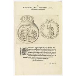
XI. Insignia et Sigilla Regum in Celon.
Theodore de Bry, a German engraver and book dealer, began a compilation of early voyages in 1590 and had published six parts at the time of his death in 1598. His widow, ...
Date: Frankfurt, 1599
Selling price: ????
Please login to see price!
Sold in 2018
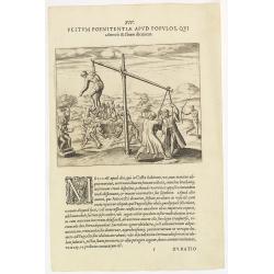
XIV. Festum Poenitentiae Apud Populos, Qui. . . ( Strange ceremonies in the state of Silon.)
Strange ceremonies in the state of Silon. Among the Oriental Indians are several from Casta who, whenever a man dies, digs a large pit. Then the corpse is placed in the o...
Date: Frankfurt, 1599
Selling price: ????
Please login to see price!
Sold in 2018
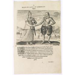
Regis in candt et Admiralis effigies. (The king of Candy meets the Dutch Admiral)
This shows the mighty king who received the name: Fimala Derura Suriada as a child in Colombo. He was also christened Don Lean d'Austria do Colombo. He is of royal blood ...
Date: Frankfurt, 1599
Selling price: ????
Please login to see price!
Sold in 2016
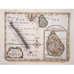
Maldivae Insulae.
A miniature map of The Maldives islands, situated southwest of Ceylon situated in the Arabian Sea, located in the Indian Ocean. North is orientated to the left. The south...
Date: Amsterdam, 1606
Selling price: ????
Please login to see price!
Sold in 2019
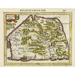
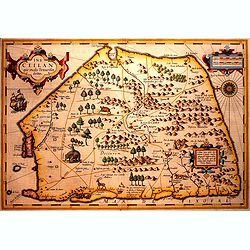
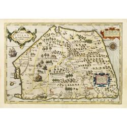
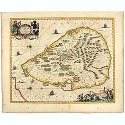
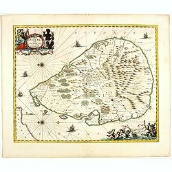
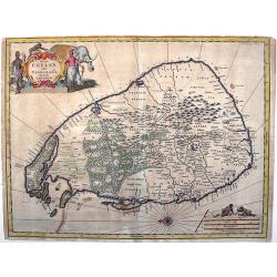
Ceilan insula.
Charming small map of the island of Sri Lanka with great detail of the villages, kingdoms, mines and spice plantations.Decorated with a strap work title and distance scal...
Date: Amsterdam, 1608
Selling price: ????
Please login to see price!
Sold in 2017
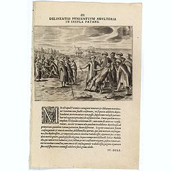
III. Delineatio Punientium Adulteria in Insula Patane. (Death of Sebald de Weerdt.)
Showing the death of Sebald de Weert (1567 – 1603) was a Dutch captain and vice-admiral of the Dutch East India Company (VOC). He is most widely remembered for accurately...
Date: Frankfurt, 1609
Selling price: ????
Please login to see price!
Sold
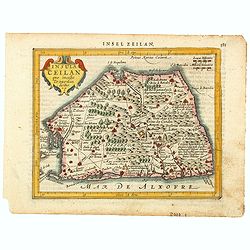
Ins. Ceilan que incolis Tenarisin dictur.
In 1606 J. Hondius introduced in the Mercator Atlas a separate map of Ceylon. Prepared by Petrus Plancius who was at the time the official map maker of the V.O.C.Early ma...
Date: Amsterdam, 1609
Selling price: ????
Please login to see price!
Sold in 2016
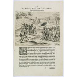
Delineatio Regis in Matecalo Hollandos. (Arrival of Sebald de Weert in Matecalo/Batticaloa).
Arrival of Sebald de Weert in Matecalo/Batticaloa, Ceylon (Sri Lanka).Theodore de Bry, a German engraver and book dealer, began a compilation of early voyages in 1590 and...
Date: Frankfurt, 1609
Selling price: ????
Please login to see price!
Sold in 2016
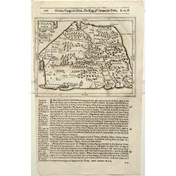
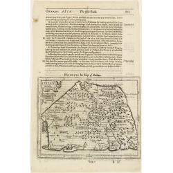
IX. Tabula Cosmographica, Regionis Sive.
Early map of Ceylon (Sri-Lanka). Theodore de Bry, a German engraver and book dealer, began a compilation of early voyages in 1590 and had published six parts at the time ...
Date: Frankfurt, 1609
Selling price: ????
Please login to see price!
Sold in 2010
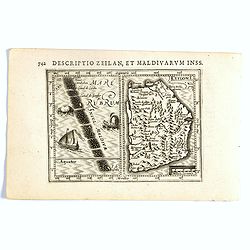
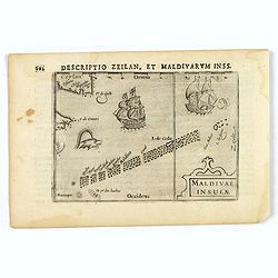
Descriptio Zeilan, Maldivarum Inss.
FIRST IMPRINT FROM THE NEWLY ENGRAVED PLATES IN 1616. - A rare miniature map of Ceylon/ Sri Lanka and Maladies. First published in 1598 in his Caert-Thresoor, the plates ...
Date: Amsterdam, J. Hondius, 1616
Selling price: ????
Please login to see price!
Sold in 2020
Ceilan Insula.
The rare Samuel Purchas' edition of the Mercator/Hondius Atlas Minor atlas map. Early map of Sri Lanka published in his famous collection of voyages His Pilgrimes . With ...
Date: London, 1625
Selling price: ????
Please login to see price!
Sold in 2020
Ceilan Insula.
The rare Samuel Purchas' edition of the Mercator/Hondius Atlas Minor atlas map. Early map of Ceylon published in his famous collection of voyages His Pilgrimes. With desc...
Date: London 1625
Selling price: ????
Please login to see price!
Sold in 2013
Ins. Ceilan que incolis Tenarisin dictur.
In 1606 J. Hondius introduced in the Mercator Atlas a separate map of Ceylon. Prepared by Petrus Plancius.
Date: Amsterdam, 1630
Selling price: ????
Please login to see price!
Sold
![[ Lot of 12 maps / views off India / Sri Lanka] Malabar.](/uploads/cache/20949-250x250.jpg)
[ Lot of 12 maps / views off India / Sri Lanka] Malabar.
Attractive little map of the southern part of the Indian subcontinent, focusing on the Malabar coast from Goa to Cape Comorin and its important trading posts. Also depict...
Date: Amsterdam, c. 1630
Selling price: ????
Please login to see price!
Sold in 2023
Insula Ceilan que Incolis Tenarisin dictur.
An oddly shaped map of the island of Ceylon (Sri Lanka), engraved by Petrus Kaerius with plenty of good detail. Major settlements highlighted in red. In 1607 Jodocus Hon...
Date: Amsterdam, 1631
Selling price: ????
Please login to see price!
Sold in 2020
Ins. Ceilan que incolis Tenarisin dictur.
In 1606 J. Hondius introduced in the Mercator Atlas a separate map of Ceylon. Prepared by Petrus Plancius
Date: Amsterdam 1633
Selling price: ????
Please login to see price!
Sold
Insula Ceilan quae incolis Tenarisin dicitur.
Single page map of Sri Lanka. Latin text on verso.
Date: Amsterdam, J.Janssonius, 1628-1634
Selling price: ????
Please login to see price!
Sold in 2020
Insula Zeilan olim Taprobana nunc incolis tenarisim.
Janssonius' map of Sri Lanka. Including many VOC settlements and forts, several major town marked with a crown. Very decorative item with two large title and scale cartou...
Date: Amsterdam, 1640
Selling price: ????
Please login to see price!
Sold in 2020
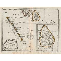
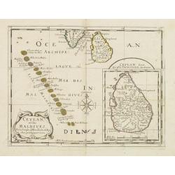
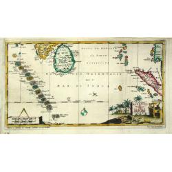
Ceylan, et les Maldives.
Map of the Maldive Islands, with an inset picturing Sri Lanka, from the first edition of the atlas L'Asie en plusieurs cartes nouvelles, et exactes & en divers traitt...
Date: Paris, 1652
Selling price: ????
Please login to see price!
Sold in 2012
Insula Zeilan olim Taprobana nunc incolis tenarisim.
Janssonius' map of Sri Lanka. Including many VOC settlements and forts, several major town marked with a crown. Very decorative item, with two large title and scale carto...
Date: Amsterdam, 1660
Selling price: ????
Please login to see price!
Sold in 2019
Ceylan et les Maldives. . .
A fine map of Shri Lanka, and the Maldives prepared by N.Sanson and published by Pierre Mariette.Published in an early edition of the small Sanson atlas L'Europe Dediée a...
Date: Paris, P. Mariette, 1667
Selling price: ????
Please login to see price!
Sold in 2008
Insula Ceylan olim Taprobana nunc incolis Lankawn.
This rare map by Baldeus is show the island of Ceylon, oriented with east at the top. Two decorative cartousche embellish the map, which -a rarity for the time - shows de...
Date: Amsterdam, ca 1670
Selling price: ????
Please login to see price!
Sold in 2017
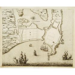
COLOMBO.
Fine plan of Colombo and surroundings, from Naauwkeurige beschryvinge van Malabar en Choromandel...
Date: Amsterdam 1672
Selling price: ????
Please login to see price!
Sold
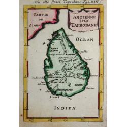
Ancienne Isle Taprobane.
Alain Manneson Mallet (1603-1706) published in 1683 his ' Description de l' Univers' in 5 volumes. In 1686 a German edition appeared.A map from Alain Manesson Mallet's 'D...
Date: Paris, 1686
Selling price: ????
Please login to see price!
Sold in 2017
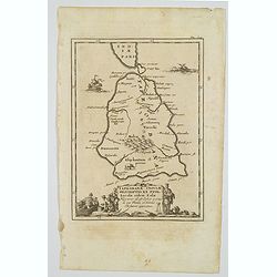
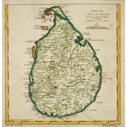
Taprobanae Insulae Descriptio ex Ptol. Incolae eidem Salae. . .
The uncommon and pleasant map of Taprobana (Sri Lanka) and the southern tip of India is based on the work of Ptolemy. It shows only ancient place names and is embellished...
Date: Utrecht, ca 1695
Selling price: ????
Please login to see price!
Sold in 2020
Ceylan, et les Maldives.
Exquisite map of Sri Lanka and the Maldives, with the southern tip of India shown at the top. Sri Lanka is shown in an inset named Ceylan Isle, qui est la Taprobane des A...
Date: Amsterdam 1700
Selling price: ????
Please login to see price!
Sold in 2026

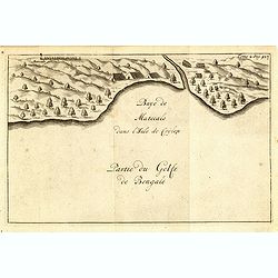
Baye de Matecalo Dans l'Isle de Ceyon / Partie du Golfe de Bengale.
Uncommon map of the Bay of Matecalo on Ceylon in the Gulf of Bengal. From the French reissue of the account of early Dutch voyages first published in 1608 by Commelin. Th...
Date: Amsterdam, E. Roger, 1703
Selling price: ????
Please login to see price!
Sold in 2016
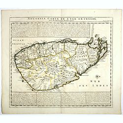
Isle de Zeilan ou Ceilon.
Uncommon map of Sri Lanka (Ceylon). From the French reissue of the account of early Dutch voyages first published in 1608 by Commelin. The French translation was carried ...
Date: Amsterdam, E. Roger, 1703
Selling price: ????
Please login to see price!
Sold in 2012
De Eilanden Maldives.
Pieter van der Aa was a prolific publisher. He published a.o. ' Naauwkeurge versameling der gedenkwaardigste zee- en land-reysen', a series of accounts of voyages (1706-0...
Date: Leiden, 1707
Selling price: ????
Please login to see price!
Sold
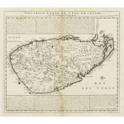
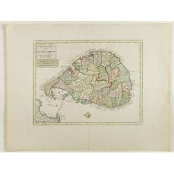
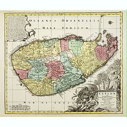
Nouvelle Carte de L'Isle de Ceylon, avec des remarques Historiques.
Handsome and very detailed map of the island. The mountainous topography is graphically presented, along with roads, locations of Dutch forts, gem and salt mines. Numerou...
Date: Amsterdam 1718
Selling price: ????
Please login to see price!
Sold
Carte de l'Isle de Ceylan.
A detailed map of Sri Lanka with soundings and two large title cartouches. Engraved by Charles Amadeus de Berey, an engraver active in Paris. Dated 1722 at the bottom of ...
Date: Paris, 1722
Selling price: ????
Please login to see price!
Sold in 2018
Carte de l'Isle de Ceylan..
Detailed map of Sri Lanka with soundings and two large title cartouches. Engraved by Charles Amadeus de Berey, an engraver active in Paris. Dated 1700.
Date: Paris 1723
Selling price: ????
Please login to see price!
Sold
Carte de l'Isle de Ceylan..
Engraved by Charles Amadeus de Berey, an engraver active in Paris. Detailed map of Shri Lanka with soundings and two large title cartouches.
Date: Paris 1723
Selling price: ????
Please login to see price!
Sold
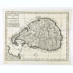
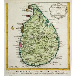
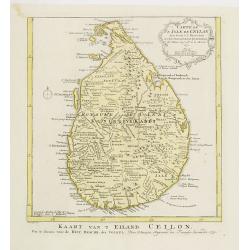
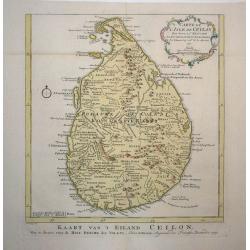
Nieuwe Kaart van het Eyland Ceylon opgestelt door..
Fine chart depicting the Island of Ceylon/Sri Lanka.Good interior detail is given with settlements, roads, etc. An attractive early map, one of the few early very detaile...
Date: Amsterdam 1724
Selling price: ????
Please login to see price!
Sold
Baye de Matecalo Dans l'Isle de Ceylon / Partie du Golfe de Bengale. ( Tome 2 Page 417)
Uncommon map of the Bay of Matecalo on Ceylon in the Gulf of Bengal. From the French reissue of the account of early Dutch voyages first published in 1608 by Commelin. Th...
Date: Amsterdam, F. Bernard, 1725
Selling price: ????
Please login to see price!
Sold in 2022
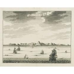
Baticalo.
Decorative panoramic view of the town of Baticalo on Ceylon. Dutch (V.O.C.) sailing ships and various local craft fill the foreground. The city with great detail includin...
Date: Amsterdam, 1726
Selling price: ????
Please login to see price!
Sold

Baay van Tricoen Male.
From Francois Valentyn's "Oud en Nieuw Oost Indien', part V : Beschryving van Coromandel, Pegu, Arrakan, Bengale, Mocha,? Persien... Malakka.. Sumatra... Ceylon.&quo...
Date: Amsterdam, 1728
Selling price: ????
Please login to see price!
Sold
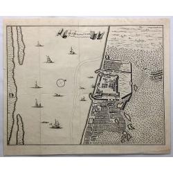
Jaffenapatnam.
A bird's eye-view of the fort and town of Jaffna. From Francois Valentyn's "Oud en Nieuw Oost Indien". The view depicts Jaffnapatnam, the fort on the coast of S...
Date: Amsterdam, 1728
Selling price: ????
Please login to see price!
Sold in 2019
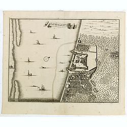
laffenapatnam.
From Francois Valentyn's "Oud en Nieuw Oost Indien, part V : Beschryving van Coromandel, Pegu, Arrakan, Bengale, Mocha, Persien, Malakka, Sumatra, Ceylon."A bir...
Date: Amsterdam, 1728
Selling price: ????
Please login to see price!
Sold in 2015
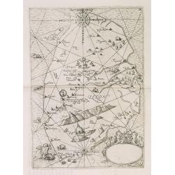
Tab. XII Asiae Taprobanam repraesentans Medius meridianus 125 ad quem reloqui inclinantur ratione aequin octalis et 9 septentrionalis
Ptolemaic map of Taprobana. The map itself depicts the island with the typical misconceptions of Ptolemy with the island straddling the Equator and showing a small part o...
Date: Amsterdam, 1578-1730
Selling price: ????
Please login to see price!
Sold in 2010
Nouvelle carte de l'Ile de Ceylon, avec des remarques Historiques.
Map of Ceylon.Henri Abraham Chatelain (1684 – 1743) was a Huguenot pastor of Parisian origins. He lived consecutively in Paris, St. Martins, London (c. 1710), the Hague (...
Date: Amsterdam, 1719-1732
Selling price: ????
Please login to see price!
Sold in 2017
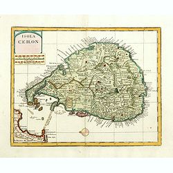
Isola Ceilon.
Attractive copper engraved map of Sri Lanka showing mountains, Towns and the Rama's Bridge (Ponte di Adamo). Included in "Atlante Novissimo che Contiene Tutte le Par...
Date: Venice, 1740
Selling price: ????
Please login to see price!
Sold in 2020
Isola Ceilon.
Attractive copper engraved map of Sri Lanka showing mountains, Towns and the Rama's Bridge (Ponte di Adamo). Included in "Atlante Novissimo che Contiene Tutte le Par...
Date: Venice, 1740
Selling price: ????
Please login to see price!
Sold in 2017
Isola Ceilon.
Attractive copper engraved map of Sri Lanka showing mountains, towns and the Rama's Bridge (Ponte di Adamo). Published by Giovanni Battista Albrizzi (1698 - 1777) and cop...
Date: Venice, 1740
Selling price: ????
Please login to see price!
Sold in 2020
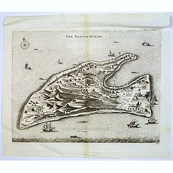
The Island of Manaer.
The island of Manaer (Mannar) is connected to northern Srl Lanka by a small causeway. This map appeared in Churchill's work 'A Collection of Voyages and Travels', and is ...
Date: London, ca. 1742
Selling price: ????
Please login to see price!
Sold in 2016
Carte de L'Isle de Ceylan Dressée sur les Observations de..
Large, detailed map of Ceylon. Embellished with 2 decorative cartouches. Latin title Insula Ceilon olim Taprobana on top.The map is from a Dutch edition of De L'Isle's wo...
Date: Amsterdam, c. 1744
Selling price: ????
Please login to see price!
Sold in 2009
Accurater Plan u See-Charte von der Insul Ceylon..
Decorative map of Ceylon and southern tip of India. Rare, from Allerneuster geographisch- und topographischer Schau-Platz von Africa und Ost-Indien.
Date: Germany, 1744
Selling price: ????
Please login to see price!
Sold in 2015
Accurater Plan u See-Charte von der Inful Ceylon..
A fine and decorative map of Ceylon and southern tip of India, presented as a sea chart. Scarce. From Allerneuster geographisch- und topographischer Schau-Platz von Afric...
Date: Germany, 1744
Selling price: ????
Please login to see price!
Sold in 2021
Carte de L'Isle de Ceylan Dressée sur les Observations...
A scarce large scale map of Sri Lanka (Ceylon). Highly detailed with many place names, rivers, hills, roads, and depth soundings shown.Embellished with two decorative car...
Date: Amsterdam, c 1745
Selling price: ????
Please login to see price!
Sold in 2016
Jaffenapatnam.
A bird's eye perspective of the fort and town of Jaffna. The view depicts Jaffnapatnam, the fort on the coast of Sri Lanka. This Portuguese built fort was captured by the...
Date: Amsterdam, 1747
Selling price: ????
Please login to see price!
Sold in 2020
Carte de L'Isle de Ceylan..
A good engraved map of Ceylon. From l'Histoire générale des voyages .
Date: Paris 1750
Selling price: ????
Please login to see price!
Sold
![[Lot of 10 maps and prints of Birma, Thailand and Malaysia.]](/uploads/cache/20085-(4)-250x250.jpg)
[Lot of 10 maps and prints of Birma, Thailand and Malaysia.]
A map of the Gulf of Bengal with the adjacent coasts of India and Sri Lanka, Bangla Desh, Birma, Thailand and Malaysia. Ref.: Gole, India within the Ganges, 62.11.1Jaques...
Date: Paris, Amsterdam, c. 1750
Selling price: ????
Please login to see price!
Sold in 2022
Nieuwe kaart van 't eiland Ceilon.
Fine map of present-day Sri Lanka with north oriented to the left. The legendary Adams Brug (Adam's Bridge or Rama's Bridge) is clearly shown linking Mannar island off Sr...
Date: Amsterdam, 1750
Selling price: ????
Please login to see price!
Sold in 2020
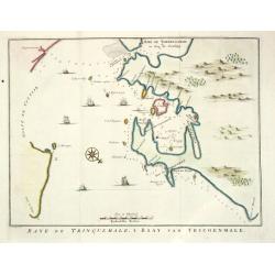
Baye de Trinquemale.
Jan van Schley is the engraver of the maps (by J.N. Bellin) and views in the Dutch edition of A.F. Prévost d' Exile's 'Histoire Géneral des Voyages.A map of Koddiyar Bay ...
Date: Amsterdam, c. 1760
Selling price: ????
Please login to see price!
Sold
Carte de l?Isle de Ceylan, 1750.
Jaques Nicolas Bellin (1702-720) was the most important French hydrographer of the 18th century. Sea-atlas 'Hydrographique Français' (1756-65) atlas to accompany Prévost ...
Date: Paris, c. 1760
Selling price: ????
Please login to see price!
Sold
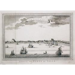
Gezicht van Punto de Galle. Plus 2 other views of the area.
[Antique view of Galle] Gezicht van Punto de Galle. Jan van Schley is the engraver of the maps (by J.N. Bellin) and views in the Dutch edition of A.F. Prévost d' Exile's ...
Date: Amsterdam, ca 1760
Selling price: ????
Please login to see price!
Sold in 2020
Carte de l?Isle de Ceylan, 1750.
Jaques Nicolas Bellin (1702-720) was the most important French hydrographer of the 18th century. Sea-atlas 'Hydrographique Français' , 1756-65, atlas to accompany Prévost...
Date: Amsterdam, c. 1760
Selling price: ????
Please login to see price!
Sold
![[Lot of 12 maps] INDIA maps+gravures - Carte De La Baye De Trinquemale Dans L’Isle De Ceylon](/uploads/cache/4100003-250x250.jpg)
[Lot of 12 maps] INDIA maps+gravures - Carte De La Baye De Trinquemale Dans L’Isle De Ceylon
[Lot of 12] INDIA maps + gravure - Carte De La Baye De Trinquemale Dans L’Isle De Ceylon.- Platte Grond van t'Fort Tricoen male met de daar aangelegen Pagoods-Berg (172...
Date: 1764
Selling price: ????
Please login to see price!
Sold in 2023
Ceylon olim Taprobana?Maris Indici Insula?
T.C. Lotter married M. Seutter's daughter in 1740 and succeeded him in 1756. Lotter used the copperplate of Seutter, he only changed the name.
Date: Augsbourg, 1770
Selling price: ????
Please login to see price!
Sold
Carte de L'Isle de Ceylan. Pour servir à l'histoire. . .
Uncommon edition of this fine map of Shri Lanka. In lower right engraved "6."From Atlas Portatif pour servir a l'intelligence de l'Histoire Philosophique et Pol...
Date: Amsterdam, 1773
Selling price: ????
Please login to see price!
Sold in 2020
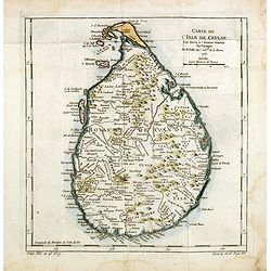
Carte de l'Isle de Ceylan
Detailed copper engraved map of the island with good detail inland of mountains, rivers, towns and villages. Rococo-style cartouche and a simple compass rose accent the m...
Date: Amsterdam, 1773
Selling price: ????
Please login to see price!
Sold in 2009
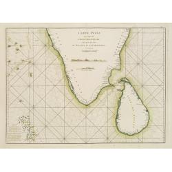
Carte Plate qui comprend l'Isle de Ceylan, une partie des Côtes de Malabar et de Coromandel.
French chart of Ceylon and southern part of India. Latitude and longitude scales, compass rose and system of rhumb lines, soundings near coast and in bay areas.D' Après d...
Date: Paris, ca 1775
Selling price: ????
Please login to see price!
Sold
Carte de l'Isle de Ceylan, pour servir à l'Histoire Générale des Voyages.
An interesting map of the island of Ceylon which is now known as Sri Lanka, includes rivers mountains forests and symbols for small towns and cities .Prepared by Jacques ...
Date: Paris, 1738-1775
Selling price: ????
Please login to see price!
Sold in 2014
