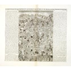
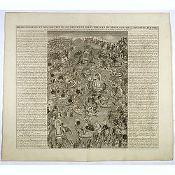
Representation Et Description Du Soulevement Des IV. Princes Du Mogol Contre L'Empereur Leur Père du Combat dans lequel Aureng-Zeb demeura vainqueur dese trois Freres & c. sit ensuite proclamer Empereur.
Fascinating engraving depicting a grand battle between the princes of the Mughal Empire. Aurangzeb was the last of the great Mughal emperors and the empire reached its la...
Date: Amsterdam, 1728
Selling price: ????
Please login to see price!
Sold in 2013
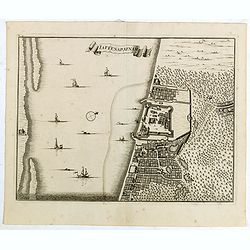
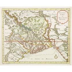
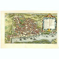
laffenapatnam.
From Francois Valentyn's "Oud en Nieuw Oost Indien, part V : Beschryving van Coromandel, Pegu, Arrakan, Bengale, Mocha, Persien, Malakka, Sumatra, Ceylon."A bir...
Date: Amsterdam, 1728
Selling price: ????
Please login to see price!
Sold in 2015
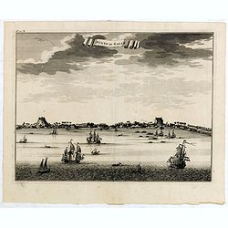
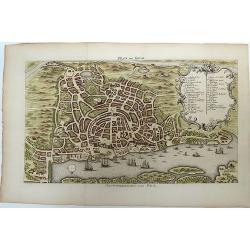
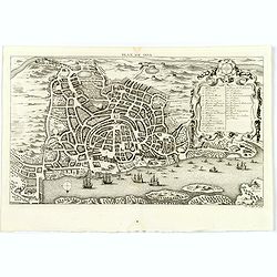
Punto de Galle.
From Francois Valentyn's "Oud en Nieuw Oost Indien', part V : Beschryving van Coromandel, Pegu, Arrakan, Bengale, Mocha, Persien, Malakka.. Sumatra, Ceylon."An ...
Date: Amsterdam, 1728
Selling price: ????
Please login to see price!
Sold in 2017

(Ichan / Cha Ichan / Oranzeb / Badour Siah)
From Chatelain's monumental 7 volume Atlas Historique. Henri Abraham Chatelain (1684 – 1743) was a Huguenot pastor of Parisian origins. He lived consecutively in Paris, S...
Date: Amsterdam, 1728
Selling price: ????
Please login to see price!
Sold in 2017
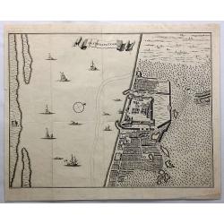
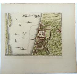
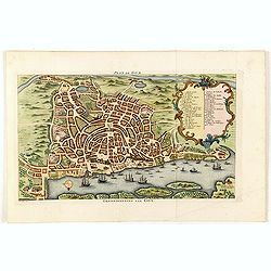
Jaffenapatnam.
A bird's eye-view of the fort and town of Jaffna. From Francois Valentyn's "Oud en Nieuw Oost Indien". The view depicts Jaffnapatnam, the fort on the coast of S...
Date: Amsterdam, 1728
Selling price: ????
Please login to see price!
Sold in 2019
Representation Et Description Du Soulevement Des IV. Princes Du Mogol Contre L'Empereur Leur Père du Combat dans lequel Aureng-Zeb demeura vainqueur dese trois Freres & c. sit ensuite proclamer Empereur.
Fascinating engraving depicting a grand battle between the princes of the Mughal Empire. Aurangzeb was the last of the great Mughal emperors and the empire reached its la...
Date: Amsterdam, 1728
Selling price: ????
Please login to see price!
Sold in 2017
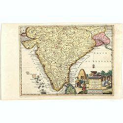
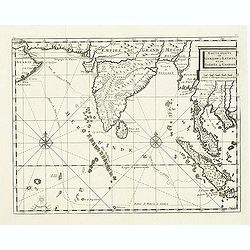
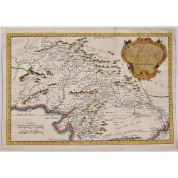
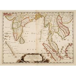
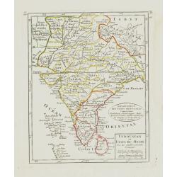
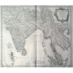
L'Inde de ça le Gange, suivant les nouvelles observations...
Uncommon edition of this map of South of India, with part of Ceylon. From Le Nouveau Theatre du Monde, ou la Geographie Royale.
Date: Amsterdam, 1728
Selling price: ????
Please login to see price!
Sold in 2021
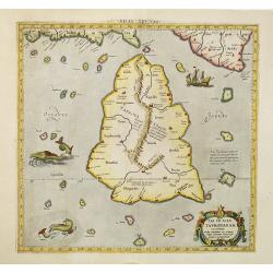
Tab. XII Asiae Taprobanam repraesentans Medius meridianus 125 ad quem reloqui inclinantur ratione aequin octalis et 9 septentrionalis
Ptolemaic map of Taprobana. The map itself depicts the island with the typical misconceptions of Ptolemy with the island straddling the Equator and showing a small part o...
Date: Amsterdam, 1578-1730
Selling price: ????
Please login to see price!
Sold in 2010

Tab.X Asiae Complectens Indiam intra gangem. . .
A Ptolemaic view of India. The Himalayan Mountains stretch across the top of the map and the Indus and Ganges river systems are well delineated. The subcontinent is consi...
Date: Amsterdam, 1730
Selling price: ????
Please login to see price!
Sold in 2010
Tab.X Asiae Complectens Indiam intra gangem. . .
A Ptolemaic view of India. The Himalayan Mountains stretch across the top of the map and the Indus and Ganges river systems are well delineated. The subcontinent is consi...
Date: Amsterdam, 1730
Selling price: ????
Please login to see price!
Sold in 2018
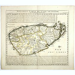
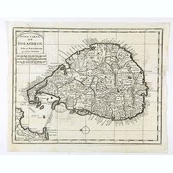
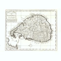
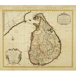
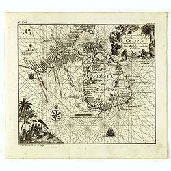
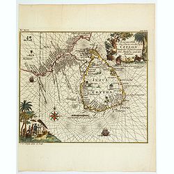
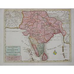
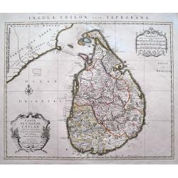
Nouvelle carte de l'Ile de Ceylon, avec des remarques Historiques.
Map of Ceylon.Henri Abraham Chatelain (1684 – 1743) was a Huguenot pastor of Parisian origins. He lived consecutively in Paris, St. Martins, London (c. 1710), the Hague (...
Date: Amsterdam, 1719-1732
Selling price: ????
Please login to see price!
Sold in 2017
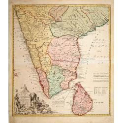
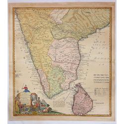
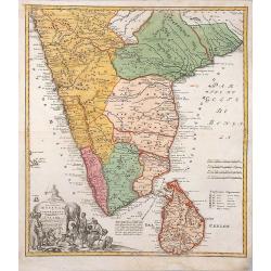
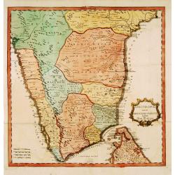
Peninsula Indiae Malabar Coromandel Ceylon.
Johann Baptist Homann's well-engraved map of southern India and Ceylon.Johann Baptist Homann (1663-1724) was a German engraver and publisher, who established himself and ...
Date: Nuremberg 1733
Selling price: ????
Please login to see price!
Sold
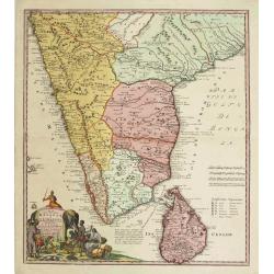
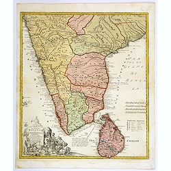
Peninsula Indiae Malabar Coromandel Ceylon.
Johann Baptist Homann's well-engraved map of southern India and Ceylon.Johann Baptist Homann (1663-1724) was a German engraver and publisher, who established himself and ...
Date: Nuremberg 1733
Selling price: ????
Please login to see price!
Sold
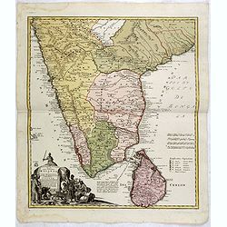
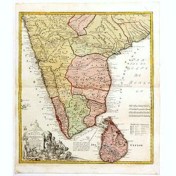
Peninsula Indiae Malabar Coromandel Ceylon.
Johann Baptist Homann's well-engraved map of southern India and Ceylon. Colonial possessions are represented by little flags to which a lettered key has been added.Johann...
Date: Nuremberg 1733
Selling price: ????
Please login to see price!
Sold in 2015
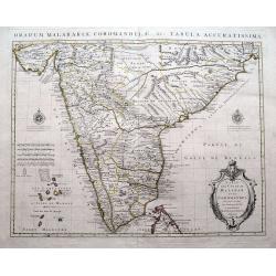
Peninsula Indiae Citra Gangem Hoc est Orae Celeberrimae Malabar & Coromandel...
A large and attractive map of Sri Lanka and the southern part of the Indian Peninsula, with an elaborate cartouche showing an elephant and elaborately clothed indigenous ...
Date: Nuremberg, 1733
Selling price: ????
Please login to see price!
Sold in 2018
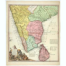
Peninsula Indiae Malabar Coromandel Ceylon.
Johann Baptist Homann's well-engraved map of southern India and Ceylon.
Date: Nuremberg 1733
Selling price: ????
Please login to see price!
Sold in 2018
Peninsula Indiae Malabar Coromandel Ceylon.
Johann Baptist Homann's well-engraved map of southern India and Ceylon. This beautiful 1733 map of Southern India and Sri Lanka or Ceylon was issued by Homann Heirs. It i...
Date: Nuremberg 1733
Selling price: ????
Please login to see price!
Sold in 2020
Peninsula Indiae Malabar Coromandel Ceylon.
Johann Baptist Homann's well-engraved map of southern India and Ceylon.Johann Baptist Homann (1663-1724) was a German engraver and publisher, who established himself and ...
Date: Nuremberg, 1733
Selling price: ????
Please login to see price!
Sold in 2020
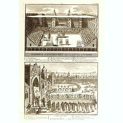
Jugement de l'Inquisition dans la grande Place de Madrid. / Procession de L'Inquisition a GOA.
Fascinating engraving depicting Spanish inquisitions in Madrid and Goa. Engraved by Bernard Picard after Kircher.Published in Jean Frederic Bernard's monumental "Cér...
Date: Amsterdam, J.F. Bernard c.1736
Selling price: ????
Please login to see price!
Sold in 2015
Route Exacte de Gamron a Batavia et De Batavia a Gamron
The map depicts his route from Gamron (modern Bandar Abas) to Batavia (Jakarta). Finely engraved with a decorative title cartouche and compass rose.Taken from "Trave...
Date: Amsterdam, 1737
Selling price: ????
Please login to see price!
Sold in 2011
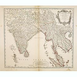
Nouvelle carte d'une grande partie de la presqu'île des Indes en deça du Gange . . .
Uncommon map of the pen insular of India prepared by Jean-Baptiste Bourguignon d' Anville (1697-1782) after Jesuit sources. The map is dated 1737 and carries the sign of ...
Date: Paris, 1737
Selling price: ????
Please login to see price!
Sold in 2012
Nouvelle carte d'une grande partie de la presqu'île des Indes en deça du Gange / dressée sur deux cartes manuscrites des RR. PP. Jésuites par le Sr. d'Anville.
Uncommon map of the pen insular of India prepared by Jean-Baptiste Bourguignon d' Anville (1697-1782) after Jesuit sources. The map is dated 1737 and carries the sign of ...
Date: Paris, 1737
Selling price: ????
Please login to see price!
Sold in 2013
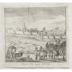
Visiapour Citta Capitale dell India.
A fine copper engraved city view of Visapur, in India by Salmon, issued in 1738.
Date: London, 1738
Selling price: ????
Please login to see price!
Sold in 2020
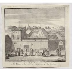
Luogo degli Inglesi a Suratte.
A fine copper engraved city view of La Chiesa, in India by Thomas Salmon in 1738.
Date: London, 1738
Selling price: ????
Please login to see price!
Sold in 2020
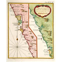
Carte des Costes de Concan et Decan..
Fine map in two parts of the west coast of India. One sheet including Bombay the other part Goa. From Petit Atlas Maritime .Jacques Nicolaas Bellin (1703-1772) was one of...
Date: Paris 1740
Selling price: ????
Please login to see price!
Sold
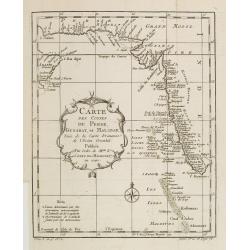
Carte des Costes de Perse, Gusarat et Malabar..
A good engraved map of the Indian Ocean, with the west coast of India, Persia, Maldives and the eastern tip of Arabia. The geographical features are typical with somewhat...
Date: Paris, 1740
Selling price: ????
Please login to see price!
Sold in 2012
Carte des Costes de Perse Guzarat et Malabar.
Uncommon edition of this accurate map showing the east coast of India, the Maldives Islands and the eastern tip of Arabia. In lower left corner a lettered key.FromAtlas P...
Date: Amsterdam, 1740
Selling price: ????
Please login to see price!
Sold in 2014
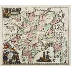
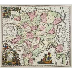
Imperii Magni Mogolis sive Indici Padschach..
Impressive map of the Mongol Empire, including present India (except the southern tip), Pakistan, Afghanistan, parts of Burma, etc.Decorated with two colored pictorial ca...
Date: Augsburg, ca 1740
Selling price: ????
Please login to see price!
Sold
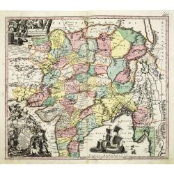
Imperii Magni Mogolis sive Indici Padschach. . .
Impressive map of the Mongol Empire, including present India (except the southern tip), Pakistan, Afghanistan, parts of Burma, etc.Decorated with two colored pictorial ca...
Date: Augsburg, ca 1740
Selling price: ????
Please login to see price!
Sold in 2011
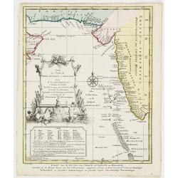
Carte du Golphe de Bengale. . .
Uncommon map of India, Ceylon and East coast of Malaysia, after J.N.Bellin. With title in Dutch in lower margin, engraved by J. van Schley. From Atlas Portatif pour serv...
Date: Amsterdam, 1740
Selling price: ????
Please login to see price!
Sold in 2011
Imperii Magni Mogolis sive Indici Padschach..
Impressive map of the Mongol Empire, including present India (except the southern tip), Pakistan, Afghanistan, parts of Burma, etc.Decorated with two colored pictorial ca...
Date: Augsburg, ca 1740
Selling price: ????
Please login to see price!
Sold in 2008
Peninsula Indiae Malabar Coromandel Ceylon.
Homann's family well-engraved map of southern India and Ceylon.
Date: Nuremberg, 1740
Selling price: ????
Please login to see price!
Sold in 2014
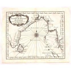
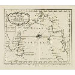
Carte du Golphe de Bengale Tire de la Carte de L'Ocean Oriental.
Striking copper engraved map of the Indian Ocean, South Eastern India and Sri Lanka, Burma & Thailand. Lovely floral, title cartouche. Jacques Nicolas Bellin (1703 –...
Date: Paris, 1740
Selling price: ????
Please login to see price!
Sold in 2016
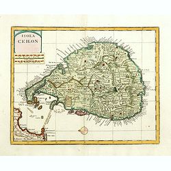
Isola Ceilon.
Attractive copper engraved map of Sri Lanka showing mountains, Towns and the Rama's Bridge (Ponte di Adamo). Included in "Atlante Novissimo che Contiene Tutte le Par...
Date: Venice, 1740
Selling price: ????
Please login to see price!
Sold in 2017
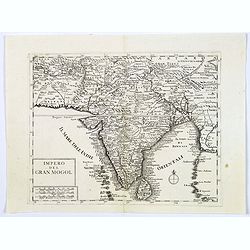
Impero del Gran Mogol.
A very fine map showing India divided into its regions with major towns and cities marked and also parts of its neighbouring kingdoms.
Date: Venice, 1740
Selling price: ????
Please login to see price!
Sold in 2017
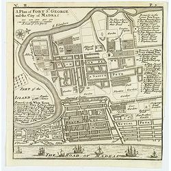
A Plan of Fort St. George and the City of Madras.
A detailed plan of the famous Fort St. George and the city of Madras (now Chennai). The fort was the first British fortification in India, built in 1639 and it still stan...
Date: London, ca 1740
Selling price: ????
Please login to see price!
Sold in 2020
Carte Des Costes de Perse, Gusarat, et Malabar.
An interesting map of the Persian Gulf, Iran and Western India including the Maldives Islands. Featuring a decorative cartouche. Jacques Nicolas Bellin (1703-1772) was on...
Date: Paris, 1740
Selling price: ????
Please login to see price!
Sold in 2019
Carte du Golphe de Bengale Tire de l'Ocean Oriental.
Bellin's detailed regional map of the Gulf of Bengal and the lower Ganges River. t features a decorative cartouche and a large compass rose in the centre.Jacques-Nicolas...
Date: Paris, 1740
Selling price: ????
Please login to see price!
Sold in 2020
Isola Ceilon.
Attractive copper engraved map of Sri Lanka showing mountains, Towns and the Rama's Bridge (Ponte di Adamo). Included in "Atlante Novissimo che Contiene Tutte le Par...
Date: Venice, 1740
Selling price: ????
Please login to see price!
Sold in 2020
Isola Ceilon.
Attractive copper engraved map of Sri Lanka showing mountains, towns and the Rama's Bridge (Ponte di Adamo). Published by Giovanni Battista Albrizzi (1698 - 1777) and cop...
Date: Venice, 1740
Selling price: ????
Please login to see price!
Sold in 2020
![[Lot of 4 maps] Magni Mogolis Imperium. de novo Correctum et Divisum.](/uploads/cache/85476-250x250.jpg)
[Lot of 4 maps] Magni Mogolis Imperium. de novo Correctum et Divisum.
An attractive map depicting the northern part of India, Afghanistan, Pakistan, Bangladesj, Nepal and Tibet. Embellished with a title-cartouche and a cartouche with scales...
Date: Amsterdam, ca 1740
Selling price: ????
Please login to see price!
Sold in 2022
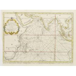
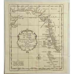
Carte De L'Ocean Oriental ou Mer Des Indes Pour Servir a l'Histoire Generale des Voyages..
Fine chart of Asia from south Africa till the western tip of Australia, including Arabia, India and Indonesia, including Philippines and Taiwan.With Dutch title in lower ...
Date: Amsterdam 1742
Selling price: ????
Please login to see price!
Sold
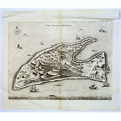
The Island of Manaer.
The island of Manaer (Mannar) is connected to northern Srl Lanka by a small causeway. This map appeared in Churchill's work 'A Collection of Voyages and Travels', and is ...
Date: London, ca. 1742
Selling price: ????
Please login to see price!
Sold in 2016
Carta dell India, Foglio II.
A fine map of the northern part of India by Bellin. A copper engraved map from the “Storia Generale de'Viaggi” di Prevost, an Italian edition of the French original “Hist...
Date: Paris, 1742
Selling price: ????
Please login to see price!
Sold in 2019
Carte de L'Isle de Ceylan Dressée sur les Observations de..
Large, detailed map of Ceylon. Embellished with 2 decorative cartouches. Latin title Insula Ceilon olim Taprobana on top.The map is from a Dutch edition of De L'Isle's wo...
Date: Amsterdam, c. 1744
Selling price: ????
Please login to see price!
Sold in 2009
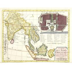
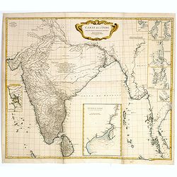
Carte des Indes orientales dressee sur les observations de l'Academie Royale des Sciences, et sur les memoires de la Compagnie des Indes.
Uncommon map of India with South East Asia, within the upper right corner inset "Plan de Pondicherry en 1741", with a key A-S, 1-21. Engraved by F.Desbruslins. ...
Date: Paris, Jean Desaint et Charles Saillant, 1744
Selling price: ????
Please login to see price!
Sold
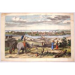
Masulipatnam.
Fine hand-colored copper engraving of a view of the city of Masulipatnam on the Malibar Coast in India. It was published in "THE TRUE & EXACT DESCRIPTION OF THE ...
Date: London, 1744
Selling price: ????
Please login to see price!
Sold in 2015
Accurater Plan u See-Charte von der Insul Ceylon..
Decorative map of Ceylon and southern tip of India. Rare, from Allerneuster geographisch- und topographischer Schau-Platz von Africa und Ost-Indien.
Date: Germany, 1744
Selling price: ????
Please login to see price!
Sold in 2015
Accurater Plan u See-Charte von der Inful Ceylon..
A fine and decorative map of Ceylon and southern tip of India, presented as a sea chart. Scarce. From Allerneuster geographisch- und topographischer Schau-Platz von Afric...
Date: Germany, 1744
Selling price: ????
Please login to see price!
Sold in 2021
Partie Meridionale de l'Inde en deux presqu'isles..
An uncommon late printing of the Sanson's important mid-seventeenth century map of India and Southeast Asia, with the engraved date 1703 (apparently the second and last s...
Date: Paris 1703/c.1745
Selling price: ????
Please login to see price!
Sold
Nieuwe Kaart van t Keyzer Ryk van den Grooten Mogol.
Izaak Tirion (d. 1769) Amsterdam publisher. His ' Nieuwe en beknopte handatlas' saw 6 editions between before 1740 and after 1784. Also ' Tegenwoordige staat van alle vol...
Date: Amsterdam, c. 1745
Selling price: ????
Please login to see price!
Sold
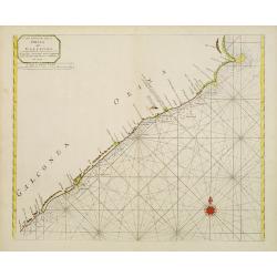
A new chart of the coast of ORIXA and GALCONDA. Carefully corrected and compared with the French charts.
Interesting and detailed navigational chart of southern part of India.
Date: London 1745
Selling price: ????
Please login to see price!
Sold
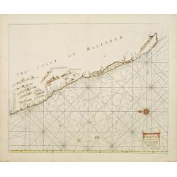
A Large Draught of the Mallabar Coast..
Important chart of the coast centred on Calcutta. From the East India Pilot . Detailed map with compass roses and system of rhumb lines, soundings and anchorage's. Many p...
Date: London 1745
Selling price: ????
Please login to see price!
Sold
Carte des Côtes de Malabar et de Coromandel...
A fantastic map of southern India. Indicates the names of the European countries in power in several cities, for example "Cochin aux Hollandois"; "Pondiche...
Date: Amsterdam, c1745
Selling price: ????
Please login to see price!
Sold in 2016
Carte de L'Isle de Ceylan Dressée sur les Observations...
A scarce large scale map of Sri Lanka (Ceylon). Highly detailed with many place names, rivers, hills, roads, and depth soundings shown.Embellished with two decorative car...
Date: Amsterdam, c 1745
Selling price: ????
Please login to see price!
Sold in 2016
Nouvelle carte du Royaume de Bengale.
Rare map of Bangladesh with the Ganges delta, including Calcutta. Giving great detail with trade routes, European trade settlements, etc. Prepared by Joh. Van Leenen who ...
Date: Paris 1746
Selling price: ????
Please login to see price!
Sold in 2020
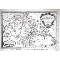
Mogol.
An attractive map of northern India with decorative cartouche, from 'Methode pour apprendre facilement la Geographie' by Jacques Robbe.small decorative title cartouche. W...
Date: Paris, 1746
Selling price: ????
Please login to see price!
Sold in 2017
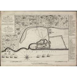
Plan de Goa. Grondtekening van Goa.
A beautifully detailed and engraved town-plan of the Portuguese colony of Goa in India, with a number key (1-29) to the city's major monuments and sites, enclosed in a de...
Date: Amsterdam, 1747
Selling price: ????
Please login to see price!
Sold in 2020
Jaffenapatnam.
A bird's eye perspective of the fort and town of Jaffna. The view depicts Jaffnapatnam, the fort on the coast of Sri Lanka. This Portuguese built fort was captured by the...
Date: Amsterdam, 1747
Selling price: ????
Please login to see price!
Sold in 2020
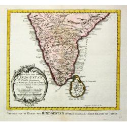
Indoustan ou Etats du Mogol Avec les établissements Français.
Small detailed map of India, including Sri Lanka and the Maldives. From Atlas Portatif Universel, by Robert de Vaugondy.Edited by : "Au dépôt de Géographie, Rue Geof...
Date: Paris, later than 1748
Selling price: ????
Please login to see price!
Sold
..Karte von der halb=Insil Indiens diesseits dem Ganges.
Fine map of India and northern part of Sri-Lanka. Text is in German. The map is decorated with small elephants, Lions, trees, etc.RARE. Engraved by Christian Liebe, engra...
Date: Halle c. 1750
Selling price: ????
Please login to see price!
Sold
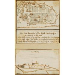
Die Stadt Frankenbar and fort Dansburg.
Charming 18th water color on paper depicting the fortification and town plan of the Danish East India Company Trading post Dansburg on the Indian west coast.In top the ci...
Date: c.1750
Selling price: ????
Please login to see price!
Sold
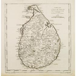
Carte de L'Isle de Ceylan..
A good engraved map of Ceylon. From l'Histoire générale des voyages .
Date: Paris 1750
Selling price: ????
Please login to see price!
Sold
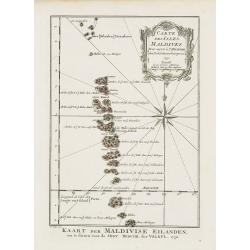
Carte des Isles Maldives.
A very nice map of the Maldives Islands from Atlas Portatif pour servir a l'intelligence de l'Histoire Philosophique et Politique des etablissements et du commerce des Eu...
Date: Amsterdam, 1750
Selling price: ????
Please login to see price!
Sold in 2018
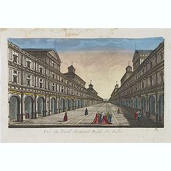
Vue du serail du grand Mogol, des Indes.
Optical print of a Mogul Palace in India. Published by Jacques Chereau, who was a well-known publisher of optical prints, established in rue St. Jacques in Paris. In the ...
Date: Paris, ca. 1750
Selling price: ????
Please login to see price!
Sold in 2019
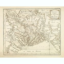
Nouvelle carte du Royaume de Bengale.
Detailed regional map of the Gulf of Bengal and the lower Ganges River.
Date: Paris, c.1750
Selling price: ????
Please login to see price!
Sold in 2015
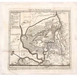
Carte du District de Tranquebar.
Decorative, detailed plan of Tharangambadi India, on the Coromandel Coast. It was founded by the Danish East India Company in 1620 and was sold to England in 1845. The ma...
Date: Paris, 1750
Selling price: ????
Please login to see price!
Sold in 2015
Plan de Goa.
A beautifully detailed and engraved town-plan of the Portuguese colony of Goa in India, with a number key (1-29) to the city's major monuments and sites, enclosed in a de...
Date: Paris, 1750
Selling price: ????
Please login to see price!
Sold in 2017
Nieuwe kaart van 't eiland Ceilon.
Fine map of present-day Sri Lanka with north oriented to the left. The legendary Adams Brug (Adam's Bridge or Rama's Bridge) is clearly shown linking Mannar island off Sr...
Date: Amsterdam, 1750
Selling price: ????
Please login to see price!
Sold in 2020
Plan de Goa.
A beautifully detailed and engraved town-plan of the Portuguese colony of Goa in India, with a number key (1-29) to the city's major monuments and sites, enclosed in a de...
Date: Paris, 1750
Selling price: ????
Please login to see price!
Sold in 2020
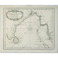
Carte du Golphe de Bengale.
A fine copper engraved map of the Gulf of Bengal including the island of Celon. It features a decorative title cartouche and a large fancy compass rose. Bellin prepared t...
Date: Paris, 1750
Selling price: ????
Please login to see price!
Sold in 2021
![[Lot of 10 maps and prints of Birma, Thailand and Malaysia.]](/uploads/cache/20085-(4)-250x250.jpg)
[Lot of 10 maps and prints of Birma, Thailand and Malaysia.]
A map of the Gulf of Bengal with the adjacent coasts of India and Sri Lanka, Bangla Desh, Birma, Thailand and Malaysia. Ref.: Gole, India within the Ganges, 62.11.1Jaques...
Date: Paris, Amsterdam, c. 1750
Selling price: ????
Please login to see price!
Sold in 2022
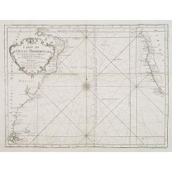
Carte de l'Ocean Meridional. . .
Map of the southern Atlantic Ocean including South America and South African coastlines. From "Voyage Autour du Monde, Fait dans les Années MDCCXL, I, II, III, IV. P...
Date: Amsterdam, 1751
Selling price: ????
Please login to see price!
Sold in 2008
A Plan of Madras and Fort St. George, Taken by the French, Commanded by Monsieur Martre de la Bourdonnais. / Plan de Madras et du Fort St. Georges, pris parles Francois, Commandes par Mr. Matre de la Bourdonnais
A very rare plan of Madras during the Carnatic WarsThis copper engraved plan of Madra in India was published by John Rocque in 1751 and engraved by one of his employees R...
Date: London, 1751
Selling price: ????
Please login to see price!
Sold in 2010
Les Indes Orientales ou sont distingues les Empires et Royaumes quelles contiennent, tirees du Neptune Oriental.
An early edition of Robert de Vaugondy's map from his Atlas Universel. Reaches from Pakistan (with Candahar and Caboul) to Sumatra and Singapore. Includes India, the Male...
Date: Paris, 1751
Selling price: ????
Please login to see price!
Sold in 2011
Les Indes Orientales, ou sount distingues les Empires et Royaumes..
Interesting regional map extending from India, the Ganges and the Maldive Islands to Hai-nan, Cochinchina, Malacca and Sumatra. Includes islands, "Sinca poura" ...
Date: Paris, 1751
Selling price: ????
Please login to see price!
Sold
Carte de l' Indoustan IIe Feuille, comprenant la Presqu' Isle de l' Inde. 1752.
Jaques Nicolas Bellin (1702-720) was the most important French hydrographer of the 18th century. Sea-atlas 'Hydrographique Français' , 1756-65, atlas to accompany Prévost...
Date: Paris, 1752
Selling price: ????
Please login to see price!
Sold
Plan de Goa. Grondtekening van Goa.
A beautifully detailed and engraved town-plan of the Portuguese colony of Goa in India, with a number key (1-29) to the city's major monuments and sites, enclosed in a de...
Date: Amsterdam, 1752
Selling price: ????
Please login to see price!
Sold in 2017
Carte de l'Inde Dressee pour la Compagnie des Indes par le Sr. d'Anville Secretaire de S.A.S.Mgr. le Duc d'Orleans Novembre 1752.
A decorative large scale map printed on four joined sheets by the renowned and influential French map maker Jean-Baptiste D'Anville. D'Anville based his cartography on Je...
Date: Paris, 1752
Selling price: ????
Please login to see price!
Sold
Carte de l' Indoustan Ie Feuille, 1752.
Jaques Nicolas Bellin (1702-720) was the most important French hydrographer of the 18th century. Sea-atlas 'Hydrographique Français', 1756-65, an atlas to accompany Prévo...
Date: Paris, 1752
Selling price: ????
Please login to see price!
Sold in 2017
