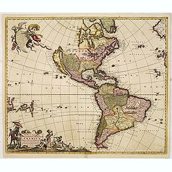
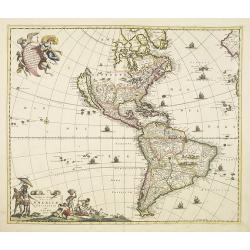
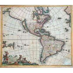
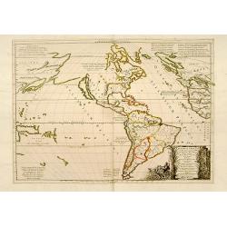
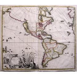
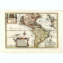
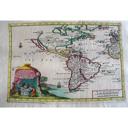
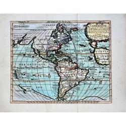
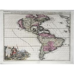
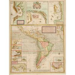
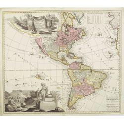
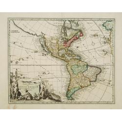
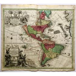
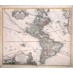
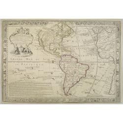
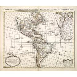
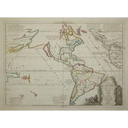
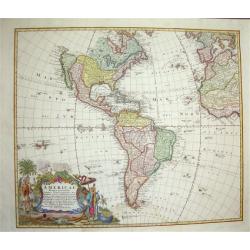
Novissima et Accuratissima Totius Americae Descriptio.
Second state of Visscher's map of the Americas, this decorative map greatly influenced the cartography of the Americas both geographically and artistically.Although it di...
Date: Amsterdam, 1677
Selling price: ????
Please login to see price!
Sold in 2013
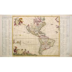
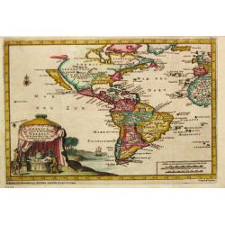
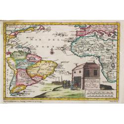
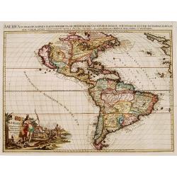
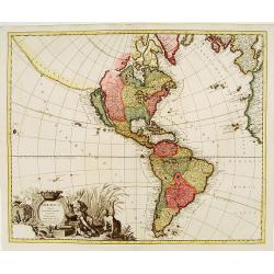
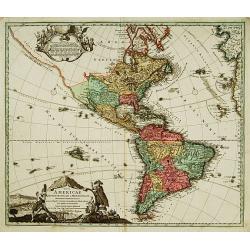
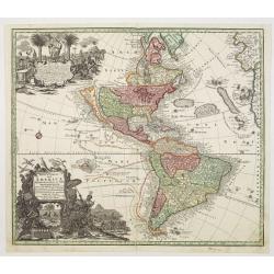
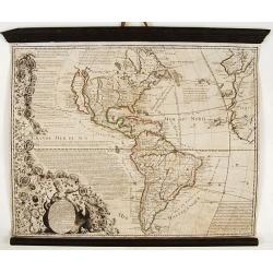
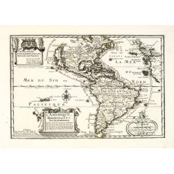
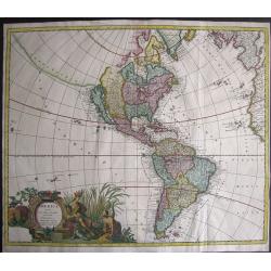
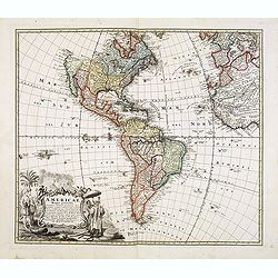
Novissima et Accuratissima Totius Americae descriptio..
One of the classic Dutch maps of the Americas and one of the most often copied.On either side of the map are tables listing the Cities, keyed to the map. Lower right hand...
Date: Amsterdam 1680
Selling price: ????
Please login to see price!
Sold
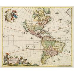
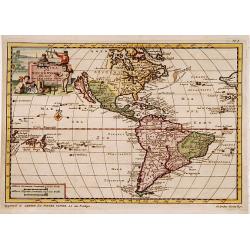
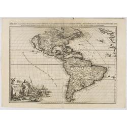
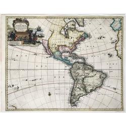
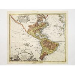
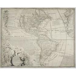
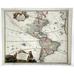
Novissima et Accuratissima Totius Americae descriptio..
One of the classic Dutch maps of the Americas and one of the most often copied.Lower right hand corner F. de Wit excudit. Several editions would appear through the end of...
Date: Amsterdam 1680
Selling price: ????
Please login to see price!
Sold
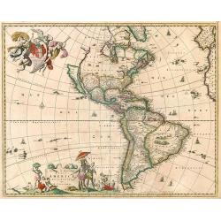
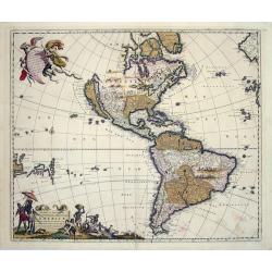
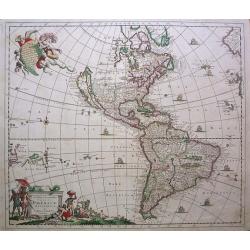
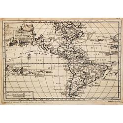
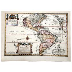
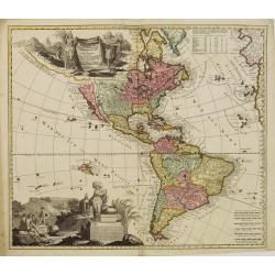
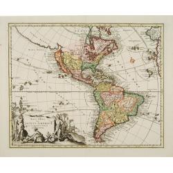
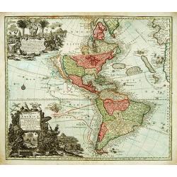
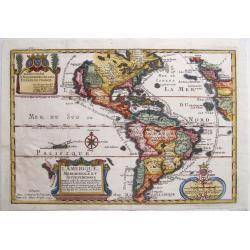
Novissima et Accuratissima Totius Americae descriptio.
Visscher's map of the Americas, this decorative map greatly influenced the cartography of the Americas both geographically and artistically.Although it did not provide mu...
Date: Amsterdam, 1658 - 1680
Selling price: ????
Please login to see price!
Sold in 2010
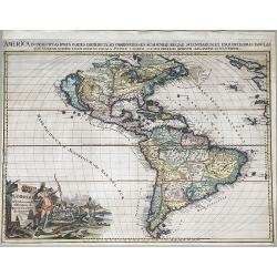
Novissima et Accuratissima Totius Americae descriptio..
One of the classic Dutch maps of the Americas and one of the most often copied. Lower right hand corner F. de Wit excudit.Several editions would appear through the end of...
Date: Amsterdam, 1680
Selling price: ????
Please login to see price!
Sold in 2013
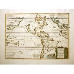
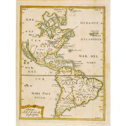
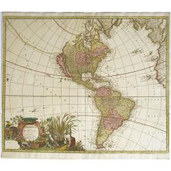
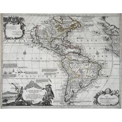
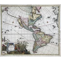
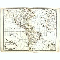
Novissima et Accuratissima Septentrionalis ac Meridionalis Americae...
An attractive, original color map of North and South America.The map was originally based on the Visscher map of 1670 of the Americas. What is especially interesting abo...
Date: Amsterdam, (1670) 1680
Selling price: ????
Please login to see price!
Sold in 2014
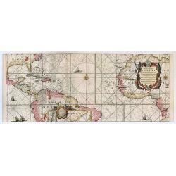
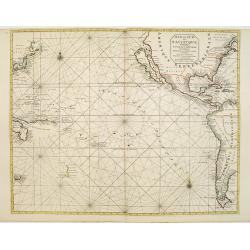
West-Indische Paskaert waer in de graden der breedde over weder zijden vande middellijn wassende so vergrooten dat die geproportioneert sijn tegen hunne nevenstaende graden de lengde.
This is the second state of Goos' version of the West Indische Paskaert, published by Johannes Van Keulen, first published circa 1680.This second state was issued both as...
Date: Amsterdam, 1680
Selling price: ????
Please login to see price!
Sold in 2017
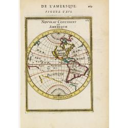
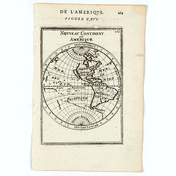
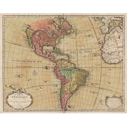
Nouveau Continent ou Amerique.
Attractive map of the western globe showing the American continent and large part of the Pacific ocean. It outlines the coasts of Australia and Antarctica according to th...
Date: Paris 1683
Selling price: ????
Please login to see price!
Sold
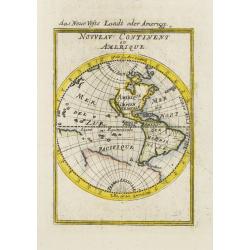
Nouveau Continent ou Amerique.
A charming map of the Western Hemisphere with California as an island . Title in curtain draped at top. French text on verso.From the original 1683 text edition of "...
Date: Paris, 1683
Selling price: ????
Please login to see price!
Sold in 2020
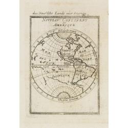
Nouveau continent ou Amerique.
A charming late 17th century French map of the Americas, showing California as an island of Brigg's type, with flat northern coast and no name labeled.The north-western c...
Date: Franckfurt 1684
Selling price: ????
Please login to see price!
Sold
Nouveau Continent ou Amerique.
Attractive map of the western hemisphere showing the American continent and large part of the Pacific ocean. It outlines the coasts of Australia and Antarctica according ...
Date: Frankfurt, 1684
Selling price: ????
Please login to see price!
Sold in 2008
Americae nova discriptio.
A map of America that was never included in an atlas and of which only five other copies are known to exist. The map has original colors although the colors have faded a ...
Date: Amsterdam, 1687
Selling price: ????
Please login to see price!
Sold in 2019
![[ America]](/uploads/cache/30316-250x250.jpg)
[ America]
Charming wood block map of America by the Italian XVIth and XVIIth century writer, humanist and cartographer Giuseppe Rosaccio. Taken from "Teatro del mondo e sue pa...
Date: Bologna, 1594 - 1688
Selling price: ????
Please login to see price!
Sold in 2014
![[4 sheets] America Settentrionale Colle Nuove Scoperte Sin All Anno 1688](/uploads/cache/23437-250x250.jpg)
[4 sheets] America Settentrionale Colle Nuove Scoperte Sin All Anno 1688
Gorgeous example of Coronelli's famous four- sheet map of America. One of the best examples of California as an island. The map also includes extensive annotations on the...
Date: Venice 1690
Selling price: ????
Please login to see price!
Sold
![America Settentrionale Colle Nuove Scoperte Sin All Anno 1688. . . (together with] America meridionale . . .](/uploads/cache/31293-250x250.jpg)
America Settentrionale Colle Nuove Scoperte Sin All Anno 1688. . . (together with] America meridionale . . .
Gorgeous example of Coronelli's famous four- sheet map of America. One of the best examples of California as an island. The map also includes extensive annotations on the...
Date: Venice, 1690
Selling price: ????
Please login to see price!
Sold in 2011
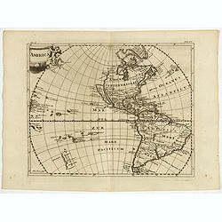
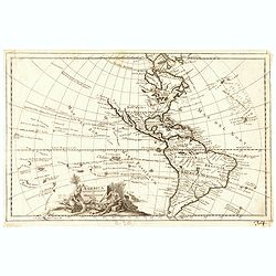
Recentissima Novi Orbis Sive Americae Septentrionalis et Meridionalis Tabula. . .
First state of Danckerts map of the Americas. California depicted as an Island, mostly based on Sanson second projection. The Great Lakes (also based on Sanson) and early...
Date: Amsterdam, 1690
Selling price: ????
Please login to see price!
Sold in 2012
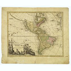
Novissima et Accuratissima Totius Americae.
An uncommon and elegant Dutch map of the Americas.
Date: Amsterdam, c.1690
Selling price: ????
Please login to see price!
Sold in 2014
![America Settentrionale Colle Nuove Scoperte Sin All Anno 1688. . . (together with] America meridionale . . .](/uploads/cache/40673-250x250.jpg)
America Settentrionale Colle Nuove Scoperte Sin All Anno 1688. . . (together with] America meridionale . . .
Gorgeous example of Coronelli's famous four- sheet map of America. One of the best examples of California as an island. The map also includes extensive annotations on the...
Date: Venice, 1690
Selling price: ????
Please login to see price!
Sold in 2018
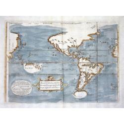
Atlantis Insula a Nicolao Sanson Antiquitati Restituta..
This is Sanson's unusual composition showing ancient geography within a contemporary outline of the Americas, which is noted in the cartouche as the mythical island of At...
Date: Padua, 1694
Selling price: ????
Please login to see price!
Sold in 2012
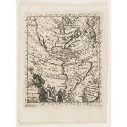
America.
Interesting map of America showing California as an island and completely omitting the Great Lakes. From Philipp Clüver's famous Introductionis in Universam geographicam,...
Date: Amsterdam, 1697
Selling price: ????
Please login to see price!
Sold in 2017
Atlantis Insula.
Third state (of five) of the unusual map that purports to show the earth about 200,000 years ago before its settlement by humans. The god Neptune had divided up the land ...
Date: Paris 1699
Selling price: ????
Please login to see price!
Sold
Mer de Sud ou Pacifique contenant l'Isle de Californe. . .
Intriguing map of the Pacific copied from important manuscript maps collected by the Portuguese crown and secreted away in Portuguese archives. Showing California with in...
Date: Amsterdam, 1700
Selling price: ????
Please login to see price!
Sold in 2016
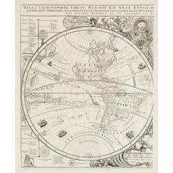
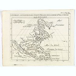
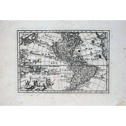
Title in Greek (Sub-title: Index Geographicus tum vete..)
This sheet covers the western hemisphere, with California as an island, and has Greek lettering throughout. As stated in the long Greek title and Latin sub-title it is th...
Date: Padua, 1700
Selling price: ????
Please login to see price!
Sold in 2010
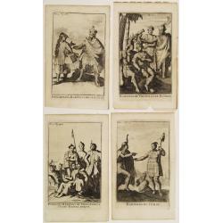
Four engravings by M. Duplessis.
4 decorative engravings representing native American people.Mexiquains. Habitans des Antiles.Habitans de Virginie et de Floride.Habitans du Perou.Patagons. Habitans du Ch...
Date: Amsterdam 1700
Selling price: ????
Please login to see price!
Sold
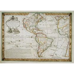
Recentissima Novi Orbis sive Americae Septentrionalis et Meridionalis Tabula ex officina Caroli Allard . . .
Map of estern hemisphere by Carol Allard (1614-1709); drawn by Ph.Tideman, engraved G. van Gouwen. from: Atlas Minor', published Amsterdam, c1700. 3rd state with climates...
Date: Amsterdam, ca. 1700
Selling price: ????
Please login to see price!
Sold in 2016
Totius Americae Descriptio.
Rare map of America with California as an island on Briggs model and lacking detail to north. From Kort Beskrifning Om Provincien Nya Swerige uti AMERICA, som nu fortjden...
Date: Stockholm 1702
Selling price: ????
Please login to see price!
Sold
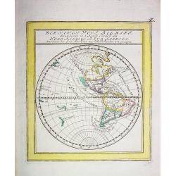
Der neuen West Begriff...
Scarce German miniature map of the Western Hemisphere showing California as an Island, a partial coast of New Zealand and a misshaped South America. The western coast of ...
Date: Augsburg 1704
Selling price: ????
Please login to see price!
Sold
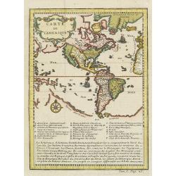
Carte du gouvernement de l'Amerique.
A double page map including a fine map of America, with California as an island with indented northern coastline. Lots of text and four insets of four governments of the ...
Date: Amsterdam, 1705
Selling price: ????
Please login to see price!
Sold in 2011
L'Amerique, Meridionale et Septentrionale.
Fine map of the Western hemisphere showing California with indented northern coast: Agubela de Cato to north. Includes partial outline of New Zealand. Interesting Great L...
Date: Paris, 1705
Selling price: ????
Please login to see price!
Sold in 2021
![L'AMERIQUE, Meridionale et Septenstrionale.[California island]](/uploads/cache/83556-250x250.jpg)
L'AMERIQUE, Meridionale et Septenstrionale.[California island]
A fine map of the Western hemisphere showing California as an island with indented northern coast: Agubela de Cato to north. Includes partial outline of New Zealand. Inte...
Date: Paris, 1705
Selling price: ????
Please login to see price!
Sold in 2020
America, of Nieuw-Ontdekte Wereld, tot de Beschryving van Joseph d\'Acosta afgebakend.
Pieter van der Aa was a prolific publisher. He published a.o. ' Naauwkeurge versameling der gedenkwaardigste zee- en land-reysen', a series of accounts of voyages (1706-0...
Date: Leiden, 1706
Selling price: ????
Please login to see price!
Sold in 2010
Amerika of de Nieuwe Weereld.
A fine detailed map centred on the American continent. With charming pictorial title piece on the upper left-hand corner.Although not renowned for the originality of his ...
Date: Leiden 1707
Selling price: ????
Please login to see price!
Sold
Amerika of de Nieuwe Wereld.
Pieter van der Aa was a prolific publisher. He published a.o. ' Naauwkeurge versameling der gedenkwaardigste zee- en land-reysen', a series of accounts of voyages (1706-0...
Date: Leiden, 1707
Selling price: ????
Please login to see price!
Sold
America of Nieuw Ontekte Weereld tot de Beschryving Joseph D'Acosta afgebakend
An interesting 1707 Van Der Aa map of the Western Hemisphere showing one open-ended Great Lake, a misshapen Hudson Bay, California as an island, spurious North American m...
Date: Leiden, 1707
Selling price: ????
Please login to see price!
Sold in 2017
A. Knivets zeldzame Reystogt door de Straat Magellaan na de Zuyd Zee tot aan zijn Vlugt in Angola achtervolgt. 3262 / H. Benzös scheeps-togt uit Italien over Spanje na de Westindize Eylanden, en Kusten van' t Zuider America. 3285
Together 2 map of the Americas. Published by Pieter van der Aa who was a prolific publisher. He published a.o. ' Naaukeurige versameling der gedenkwaardigste zee- en land...
Date: Leiden, 1707
Selling price: ????
Please login to see price!
Sold in 2021
America Aurea Pars Altera Mundi
This ornamental map of the Americas depicts California as an island with a northern coastline indented by two bays on the second Sanson model. California is separated fro...
Date: Amsterdam, 1708
Selling price: ????
Please login to see price!
Sold in 2012
![[Lot of 3 maps of America] AMERICA.](/uploads/cache/48389-250x250.jpg)
[Lot of 3 maps of America] AMERICA.
An excellent small map of the American continent by Herman Moll, 1709. Showing California as an island. 265 x 200mm.- South America, small map engraved for Walkers Geogra...
Date: London, 1709
Selling price: ????
Please login to see price!
Sold in 2022
Novi Orbis sive Totius Americae cum adiacentibus Insulis. . .
A nice map of the Americas, supplemented by a splendidly decorative title cartouche in the lower left corner of the map. It features native Indians and a Westerner smokin...
Date: Nuremberg, 1710
Selling price: ????
Please login to see price!
Sold in 2017
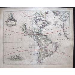
L'Amerique, Dressee sur les Observations de Mrs. de l'Academie Royale des Sciences, et suivant les Memoires les moins suspects.
A nice, scarce map depicting the American continent with the known towns, rivers and lakes. It shows the mythical 'Terre de Jesso', Tierra del Fuego is depicted as an isl...
Date: Paris, 1710
Selling price: ????
Please login to see price!
Sold in 2018
L'Amérique selon les nouvelles..
Rare. Van der Aa's lavish engraving makes his maps among the most prized of the early eighteenth century. This is one of the most attractive and superbly engraved of all ...
Date: Leiden 1713
Selling price: ????
Please login to see price!
Sold
L'Amerique Selon les nouvelles Observations de Messrs de l'Academie des Scineces etc.
Scarce map. Pieter van der Aa's lavish engraving makes his maps among the most prized of the early eighteenth century. This is one of the most attractive and superbly eng...
Date: Leiden, 1713
Selling price: ????
Please login to see price!
Sold in 2020
L'Amerique Selon les nouvelles observations de Messrs. de l'Academie des Sciences.
A striking large format map of America, published in Leiden by Pierre van der Aa, in 1713. The map features California as an Island and a projection of the Mississippi pu...
Date: Leiden, 1713
Selling price: ????
Please login to see price!
Sold in 2023
America in Praecipuas Ipsius Partes Distributa ad Observationes. . . 1713.
A large impressive map of the Americas, Western Hemisphere. Full title above: 'America in praecipuas ipsius partes distributa ad observationes Academiae regiae scientiaru...
Date: Leiden, 1713
Selling price: ????
Please login to see price!
Sold in 2020
America Aurea pars altera mundi.
California is copied from second Sanson map, with rugged coastline throughout, and with Fretum Anianiand Terra Esonis to northwest.Place names along California coast, but...
Date: Amsterdam c. 1714
Selling price: ????
Please login to see price!
Sold
Nouvelle Carte de L' Amerique.
A decorative early 18th century map with California as an island. Full title and impressum in a cartouche top left: 'Nouvelle Carte de L' Amerique, avec tous ses Royaumes...
Date: Leiden, 1714
Selling price: ????
Please login to see price!
Sold in 2020
L' AMERIQUE MERIDIONALE ET SEPTENTRIONALE.
A striking example of N. De Fer's desirable map of the Americas. In North America, California is shown as an Island with coastal names. An early Great Lakes configuration...
Date: Paris, 1717
Selling price: ????
Please login to see price!
Sold in 2019
A New & Exact Map of the Coast, Countries and Islands within ye Limits of ye South Sea Company from ye River Aranoca to Terra del Fuego and from thence through ye South Sea, to ye North Part of California &c. . . . (Galapagos Islands!)
Very decorative map of the whole of South America extending north as far as the island California and Florida. Numerous insets including Acapulco, the Galapagos Islands, ...
Date: London, 1719
Selling price: ????
Please login to see price!
Sold in 2019
Totius Americae Septentrionalis et Meridionalis.
Richly ornamented map of North and South America. Title cartouche bottom left is copied from De Fer's map of 1699 and cartouche containing text (top left) is based on De ...
Date: Nuremberg 1720
Selling price: ????
Please login to see price!
Sold
Totius Americae Septentrionalis et Meridionalis..
Richly ornamented map of North and South America. Title cartouche bottom left is copied from De Fer's map of 1699 and cartouche containing text (top left) is based on De ...
Date: Nuremberg 1720
Selling price: ????
Please login to see price!
Sold
America tam Septentrionalis quam Meridionalis..
An uncommon map of the Americas with two superb pictorial (uncolored) cartouches. Engraved by A.F. Zurner and based largely on Visscher and Sanson. California is shown as...
Date: Amsterdam 1720
Selling price: ????
Please login to see price!
Sold
America tam Septentrionalis quam Meridionalis..
An uncommon map of the Americas with two superb pictorial (uncolored) cartouches. Engraved by A.F. Zürner and based largely on Visscher and Sanson. California is shown as...
Date: Amsterdam, 1720
Selling price: ????
Please login to see price!
Sold in 2020
Carte d'Amerique.
This is a typically fine map by Guillaume de l'Isle, here with the address Sur le Quay d'Horloge, dated 1722.Early second state. The west coast of North America is deline...
Date: Paris, 1722
Selling price: ????
Please login to see price!
Sold in 2012
Descripcion de las Yndias Ocidentales
Rare Spanish map of the Pacific and Americas. As usual Spain tried to limit the exploit of their geographical knowledge through piracy and therefore only allowed limited ...
Date: Madrid, c.1723
Selling price: ????
Please login to see price!
Sold
L'Amerique Septentrionale suivant M. de Lisle de l'Academie Royaume des Sciences.
An attractive copper engraving map from the Science des personnes de la cour de l'Epee et de la Robe, a rare and richly illustrated handbook for aristocrats at the French...
Date: Amsterdam, 1723
Selling price: ????
Please login to see price!
Sold in 2020
Novi Orbis Sive Totius Americae Cum Adiacentibus Insulis..
A double-page copper-engraved map, with original full coloring. The state with in the extreme north Pacific the key Gold-Catholisch Erdfarb Heydnisch [Gold = Catholic/ Ea...
Date: Nuremberg 1725
Selling price: ????
Please login to see price!
Sold
Novi Orbis Sive Totius Americae Cum Adiacentibus Insulis..
A double-page copper-engraved map, with original full coloring. California is a 1500-mile-long island, with the Strait of Anian Fretum Aniani due north and Anian an eastw...
Date: Nuremberg 1725
Selling price: ????
Please login to see price!
Sold
Novus Orbis sive America Meridionalis et Septentrionalis..
A finely engraved and decorative mid-18th century map published in Augsburg, Germany and incorporating two large decorative title cartouches upper right and bottom left. ...
Date: Augsburg 1725
Selling price: ????
Please login to see price!
Sold
L'Amerique, Meridionale, et Septentrionale.
An uncommon map of the Americas. Full title in a decorative cartouche at bottom left: 'L'Amerique, Meridionale, et Septentrionale Dressee selon les Dernieres Relations et...
Date: Paris, 1727
Selling price: ????
Please login to see price!
Sold in 2021
Novus Orbis Sive America Meridionalis et Septentrionalis.
A highly detailed and richly engraved Seutter's map of America, with two spectacular cartouches and showing California as an island. The island is based on the second San...
Date: Vienna, 1728
Selling price: ????
Please login to see price!
Sold in 2019
America aucta delineatio.
A very decorative map from a rare atlas by A.F. Zurner. The map shows a very unusual shape of California (depicted as an island) and the marvelous "Terra Iesso"...
Date: Nuremberg, 1729
Selling price: ????
Please login to see price!
Sold in 2018
Novus Orbis sive America Meridionalis et Septentrionalis..
A finely engraved and decorative mid-18th century map published in Augsburg, Germany. This map shows the state of early exploration with some of the explorer's routes in ...
Date: Augsburg c. 1730
Selling price: ????
Please login to see price!
Sold
Carte de l'Amerique.
A very nice map centered on the American continent. Title cartouche on the upper left-hand corner. Includes also a lettered key legend on the lower part of the map.
Date: Paris, ca. 1730
Selling price: ????
Please login to see price!
Sold in 2017
Totius Americae Septentrionalis et Meridionalis
A very decorative, richly decorated map of North and South America. The title cartouche on the bottom left is copied from De Fer's map of 1699, while the cartouche contai...
Date: Nuremberg, ca. 1730
Selling price: ????
Please login to see price!
Sold in 2016
Recentissima Novi Orbis, Sive Americae Septentrionalis et Meridionalis Tabula.
Attractive map of the Americas features a beautiful rich decorative title cartouche showing an Amazonian queen surrounded by riches, a sugar cane field and exotic animals...
Date: Amsterdam, ca 1730
Selling price: ????
Please login to see price!
Sold in 2020
America Septentrionalis et Meridionalis Nova.
Map of the American continent. Including the voyages of Columbus, Magellan, Le Mair, Schouten, Dampier, van Noordt.
Date: Leiden, ca. 1730
Selling price: ????
Please login to see price!
Sold in 2021
L'AMERIQUE Meridionale et Septentrionale Dressée sur les Nou
Map surrounded by portraits of the New World explorers and those on either side are illuminated with charming illustrations of the signs of the zodiac.Geographically, the...
Date: Paris, 1731
Selling price: ????
Please login to see price!
Sold
L\'AMERIQUE Meridionale et Septentrionale Dressée sur?
Map surrounded by portraits of the New World explorers and those on either side are illuminated with charming illustrations of the signs of the zodiac.Geographically, the...
Date: Paris, 1731
Selling price: ????
Please login to see price!
Sold in 2009
V. Haupt Karte America oder West Indien oder Die Neue Welt.
A rare map of America prepared by Anselm Desing (1699-1772) for "Historica auxilia". Printed by Christian Holstat Sulzbach for the publisher Johann Gastl.
Date: Regensburg, Johann Gastl, 1733 - 1734
Selling price: ????
Please login to see price!
Sold in 2014
Amérique les Francois possedent en cette partie le Canada..
Very rare separately published map of America, showing California as an island. California's insularity indefinite: Cape Blanc de S.Sebastien is labelled at its north end...
Date: Paris 1735
Selling price: ????
Please login to see price!
Sold
Amerique.
A rare map of the western hemisphere, including portraits of explorers, such as Jacques Marquette, Louis Joliet, and Robert Cavelier de La Salle. Coats of arms present in...
Date: Paris, 1735
Selling price: ????
Please login to see price!
Sold in 2020
Carte d\'Amerique dressée par l\'usage du Roy..
Fine map prepared by G.d'Isle depicting North and south America, the west coast taken north to Cap Mendocin and Cap Blanc with a note Entrée decouverte par Martin d'Aguil...
Date: Amsterdam, 1739
Selling price: ????
Please login to see price!
Sold in 2013
L\'Amerique, Meridionale et Septentrionale.
Fine map of the Western hemisphere showing California with indented northern coast: Agubela de Cato to north. Includes partial outline on Nouvelle Zeelande. Engraved by C...
Date: Paris, 1740
Selling price: ????
Please login to see price!
Sold in 2013
Totius AMERICAE Septentrionalis et Meridionalis novissima represestatio quam ex fingulis. . .
A richly ornamented map of North and South America. Title cartouche bottom left is copied from De Fer's map of 1699 and the cartouche containing text (top left) is based ...
Date: Nuremberg, 1740
Selling price: ????
Please login to see price!
Sold in 2020
L'Amerique, Meridionale et Septentrionale. Dressee selon les dernieres relations et suivant les nouvelles decouvertes dont les points principaux sont placez sur les observations de Mrs. de l'Academie Royale des Sciences. . .
A rare later issue of this map of the Americas, with decorative cartouches for the title, dedication and scale. Engraved by Inselin for the 'Atlas Curieux', California is...
Date: Paris, 1740
Selling price: ????
Please login to see price!
Sold in 2021
Novus Orbis potius Altera Continens Sive Atlantis Insula . . .
This is a very unusual map of the Americas, noted in the cartouche to illustrate the mythical island of Atlantis. The Great Lakes are shown but are still very misshapen a...
Date: Paris, 1741
Selling price: ????
Please login to see price!
Sold in 2011
America Aurea Pars Altera Mundi.
Extremely rare and gorgeous map of America, seldom offered on an auction. California is taken from the second Sanson map published by the Valk family, with rugged coastli...
Date: Amsterdam, 1741
Selling price: ????
Please login to see price!
Sold in 2014
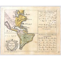
AMERICA cum Supplementis Poly Glottis.
A rare separate thematic map of AMERICA from the set of 4 maps of the continents, identifying the distribution of languages of the world from "Synopsis Universae Phi...
Date: Nurenberg, 1741
Selling price: ????
Please login to see price!
Sold in 2020
Carte d'Amerique . . .
First issued by De L'Isle in 1722. This is the seventh state of the map, unchanged geographically from the original, but with Philippe Buache's imprint at bottom right. T...
Date: Paris, 1745
Selling price: ????
Please login to see price!
Sold in 2021
Americae Mappa Generalis
An updated map of the western hemisphere by the Homann Heirs. The map shows the continent on the eve of the conflicts that would soon erupt and change the political face ...
Date: Nuremberg, ca. 1746
Selling price: ????
Please login to see price!
Sold
Americae Mappa generalis Secundum legimitas projectionis Stereiographiae regulas. . . MDCCXXXXVI
Johann Baptist Homann's well-engraved second map of America has a large decorative cartouche. Detailed map of the western hemisphere.The interior of North America has new...
Date: Nuremberg, 1746
Selling price: ????
Please login to see price!
Sold in 2013
