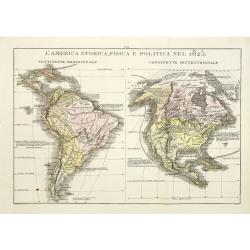
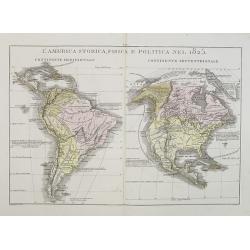
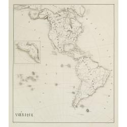
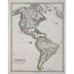
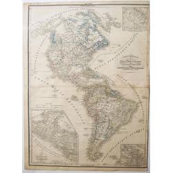
L\'America storica, fisica e politica nel 1825.
Rare and detailed map of the northern and southern part of America. According to the information on the map, prepared by Las Casas A de La Sage . From l'Atlante St.Geog.P...
Date: Venice, 1835
Selling price: ????
Please login to see price!
Sold in 2011

3 Portraits of Christopher Columbus, Queen Isabella and King Ferdinand.
Three hand-colored, steel engravings of the three individuals responsible for discovering America - Christopher Columbus and his investment bankers, Isabella and Ferdinan...
Date: London, 1838
Selling price: ????
Please login to see price!
Sold in 2013
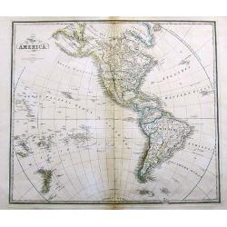
Map of America.
A large map of the Americas and the Pacific. With many interesting details, such as Russian Possessions in Alaska. Mexico seems to extend well into today's California, Ar...
Date: London, 1838
Selling price: ????
Please login to see price!
Sold in 2017
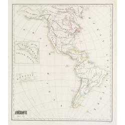
Amérique - Fevrier 1839
Fine manuscript map of America with relief shown pictorially. The Oceans in wash color and the borders in different colors. Dated 1839 and signed by the author ShuardLowe...
Date: Paris, 1839
Selling price: ????
Please login to see price!
Sold in 2016
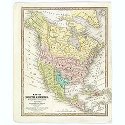
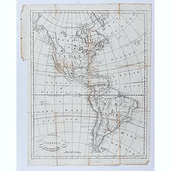
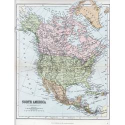
Map of North America. . .
An uncommon schoolboy map of North America, showing TX as a republic, and Alaska as "Russian Possessions." Mexico still extends well into today's California and...
Date: Hartford, ca 1839
Selling price: ????
Please login to see price!
Sold in 2018
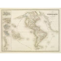
L'America Storica, Fisica e Politica nel 1825.
A rare and detailed double-page map of North and South America. From l'Atlante Storico, Letterario, Biografico, Archeologico. . . with attributions by Giambatista Albriz...
Date: Venice, 1840
Selling price: ????
Please login to see price!
Sold in 2014
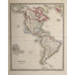
America.
Taken from "Atlas ethnographique du globe, ou classification des peuples anciens et modernes d'après leurs langues."
Date: Livorno, ca. 1842
Selling price: ????
Please login to see price!
Sold in 2020
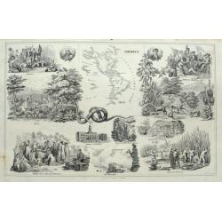
America.
Interesting sheet with a small map of the Americas surrounded by scenes and important places. From Wilhelm Penn with Indians; the Niagra Falls; Battle of Bunker Hill; vie...
Date: Stuttgart, ca. 1843
Selling price: ????
Please login to see price!
Sold in 2015
America.
Engraved, with colored margins of countries. Shows place names, roads, rivers, lakes, and islands. Relief shown with hachures. British possessions shown in red (Jamaica, ...
Date: London, 1844
Selling price: ????
Please login to see price!
Sold in 2013
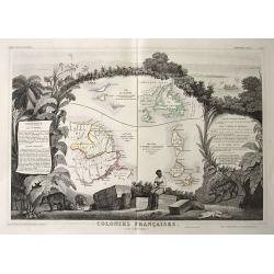
Colonies Francaises (en Amérique).
Steel engraved map of French colonies in America. Shows four maps on one sheet: 1) Saint Martin (French: Saint-Martin; Dutch: Sint Maarten) 2) Ile de Terre Neuve + I...
Date: Paris, 1846
Selling price: ????
Please login to see price!
Sold in 2016
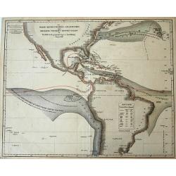
Der Warme Meeresstrom des Atlantischen und der Kalte Strom des Grossen Oceans...
Unusual thematic map of the ocean currents around the Americas. Lists the temperatures of the Gulf Stream and the Equatorial current's.
Date: Gota, ca. 1850
Selling price: ????
Please login to see price!
Sold in 2016
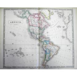
Map of America.
A large map of the Americas, and the Western hemisphere, including New Zealand, Polynesia, Greenland etc. Each country colored in outline color. Major cities, waterways a...
Date: London ca.1850
Selling price: ????
Please login to see price!
Sold in 2018
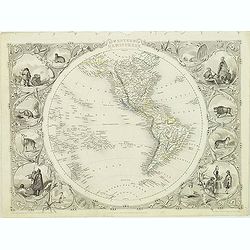
Western Hemisphere.
Decorative steel engraved map of Western Hemisphere, surrounded 12 decorative vignettes. Taken from "The illustrated atlas and modern history of the world by John Ta...
Date: London, 1851
Selling price: ????
Please login to see price!
Sold in 2012
Amérique.
Fine manuscript map of America with relief shown pictorially. Inset map of Central America called Guatemala in the left hand side.Signed by the author in the lower right ...
Date: Paris, 1852
Selling price: ????
Please login to see price!
Sold in 2017
Carte de l'Amerique..
Very detailed map of the western hemisphere, prepared by Auguste Henri Dufour (1798-1865). Published by Mrs. V.Turgis, rue Serpentine in Paris. To the left inset maps of ...
Date: Paris, 1852
Selling price: ????
Please login to see price!
Sold in 2023

United States and Canada 1853
The first Map Hitcheock,s landmark map of 1853 which is unchanged from the first edition of this report.
Date: Boston, 1853
Selling price: ????
Please login to see price!
Sold
America.
Large and detailed map of the Western Hemisphere. With "New California" labeled Russian America (Alaska) La Plata (pre Argentina) Unfinished coasts ...
Date: Liverpool, 1853
Selling price: ????
Please login to see price!
Sold in 2013
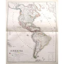
America.
A large map of the Americas with remarkable detail. Includes many early Territories shortly before statehood such as Utah, Oregon, Washington, Nebraska, etc. Shows Americ...
Date: Weimar, 1858
Selling price: ????
Please login to see price!
Sold in 2017
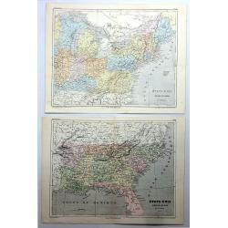
Etats-Unis, Region du Sud & Etats-Unis, Region du Nord (2 Maps).
A pair of chromo-lithograph maps featuring north and south United States. They are by A.H. Dufour and from "ATLAS POPULAIRE" published by Gustave Barba of Paris...
Date: Paris , 1860
Selling price: ????
Please login to see price!
Sold in 2017

Abraham Lincoln. Président des Ëtats-Unis.
Very fine steel engraving of Abraham Lincoln. Engraved in steel by Carl Mayer.
Date: c. 1861
Selling price: ????
Please login to see price!
Sold
America.
General map of America, published in Stieler's Hand Atlas .
Date: Gotha, 1871
Selling price: ????
Please login to see price!
Sold in 2009
A collection of 5 maps North and South America, Canada.
A collection of 5 maps North and South America, Canada by W. & A.K. Johnston and published by W & R Chambers, of London & Edinburgh.The map of Canada, South A...
Date: London, 1885
Selling price: ????
Please login to see price!
Sold in 2012
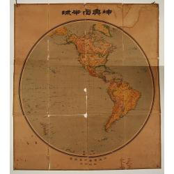
Chinese folding wall map of America.
Uncommon wall map of America, all in Chinese characters. In lower bottom Chinese manuscript characters.
Date: China c. 1930
Selling price: ????
Please login to see price!
Sold
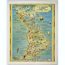
On the routes of the Flying Clipper Ships.
A fun, attractive pictorial map of North and South America by the famous aviation artist Kenneth Thompson. The Clipper Ships flew from 1931-1946. A poster that is full of...
Date: USA, ca 1940
Selling price: ????
Please login to see price!
Sold in 2018
CARTE GENERALE des Deux Ameriques.
An interesting old colored lithographed map of the American continent, with the Independent Texas Republic. From a french atlas by G.Heck.There are 3 inset maps of - the ...
Date: Paris, ca 1835
Selling price: ????
Please login to see price!
Sold in 2021
