Browse Listings in Africa > Central Africa
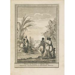
Femmes de Kazegut en differens habits.
The engraving depicts a typical Woman of Kazegut in different costumes, from "Histoire des Voyages.." by Prevost. Below title in Dutch "Vrouwen van Kazegut...
Date: Paris, Didot, ca. 1750
Selling price: ????
Please login to see price!
Sold in 2015
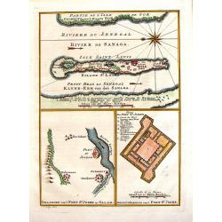
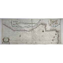
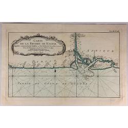
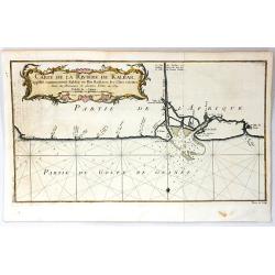
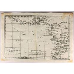
Riviere du Senegal / Isle saint Louis / Petit du Fort St. Joseph.
This 1747 nautical three charts on one page by J.C.Bellin, depicts the Senegal River and the area surrounding Fort St. Joseph & Fort St. Louis. This region was part o...
Date: Paris, 1750
Selling price: ????
Please login to see price!
Sold in 2017
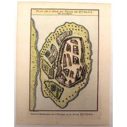
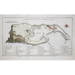
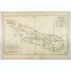
Plan de L'Isle et Ville de Quiloa.
Copper engraved plan of the fortified town of Quiloa on the east coast of Africa. This town was the center of the Portuguese slave trade.
Date: Paris, c. 1750
Selling price: ????
Please login to see price!
Sold in 2016
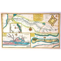
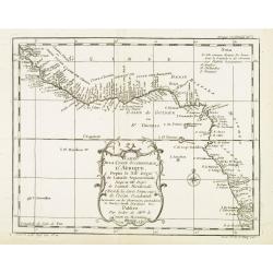
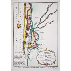
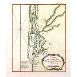
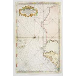
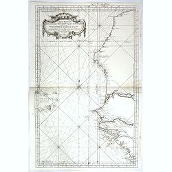
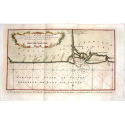
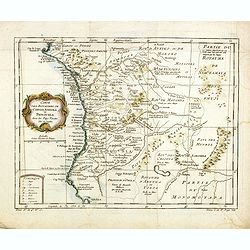
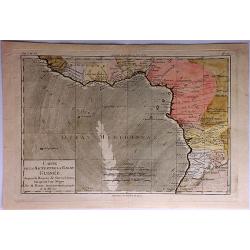
A General Map of the River Sanaga or Senegal
A map of the River Sanaga or Senegal on the west coast of Africa, from the falls of Govina to the Ocean. Main map has two insets: 1. Location of Fort St Joseph; Plan of F...
Date: Paris, 1750
Selling price: ????
Please login to see price!
Sold in 2016
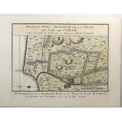
Plan du Fort Anglois et de la Ville du Cap de Corse.
Cap de Corse or Cape Coast Castle on the Gold Coast in Ghana in Africa was called the "Gate of No Return". Originally a 17th century Swedish trading post, it ul...
Date: Paris, 1750
Selling price: ????
Please login to see price!
Sold in 2018
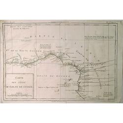
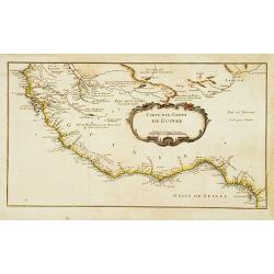
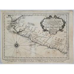
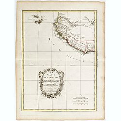
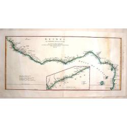
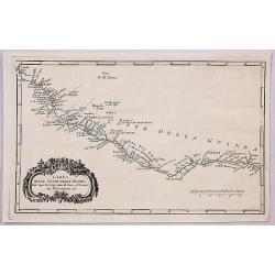
Carte des Cotes du Golfe de Guinee.
A detailed map of the Gulf (Bight) of Benin and part of the Guinea coast The map features many place names, including the Slave Coast.Jacques Nicolas Bellin (1703–1772)...
Date: Paris, 1750
Selling price: ????
Please login to see price!
Sold in 2019
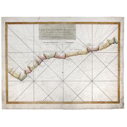
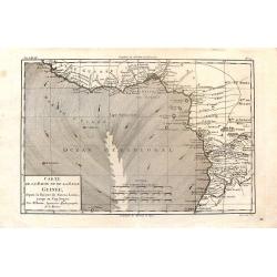
Carte Particuliere de la Coste d'Or pour servir aux Vaisseaux Du Roy.
An interesting map showing the coasts of Cote d'Ivoire, Guinee, Ghana and more. A fine early sea chart , published by the French Hydrographical Department. This chart was...
Date: Paris, 1750
Selling price: ????
Please login to see price!
Sold in 2020
![[Lot of 14 maps] Carte Generale de la Coste de la Guinée. Plus a map of the Gulf of Guinea on 2 sheets by Rigobert Bonne and 6 other maps of the Gulf of Guinea](/uploads/cache/18246-250x250.jpg)
[Lot of 14 maps] Carte Generale de la Coste de la Guinée. Plus a map of the Gulf of Guinea on 2 sheets by Rigobert Bonne and 6 other maps of the Gulf of Guinea
Jaques Nicolas Bellin (1702-720) was the most important French hydrographer of the 18th century. Sea-atlas 'Hydrographique Français' , 1756-65, atlas to accompany Prévo...
Date: Paris, 1750
Selling price: ????
Please login to see price!
Sold in 2024
Pas caert vande cuften van Angola van Rio de Zaire...
This decorative sea chart of Angola features many place names along the coast. In the upper right corner, we see a figurative title cartouche, and in the lower left corn...
Date: Amsterdam, 1751
Selling price: ????
Please login to see price!
Sold in 2016
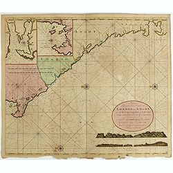
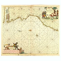
Nieuwe Paskaert van de Custen Zee Loango en Angoy van C. de Lopo Gonzalves tot R. de Zaire os Congo vertoonende alle desselfs gelegenteden.
Sea-chart of the coast of Gabon, Loango, Angoy and Angola to Zaire (Congo) River. In lower right side title and two coastal profiles. In upper left corner inset charts of...
Date: Amsterdam, ca. 1715 -1751
Selling price: ????
Please login to see price!
Sold in 2025
Carte particuliere de la Cote Occidentale de l'Afrique...
A large 2 sheet map of a part of the west coast of Africa that covers The Gambia and Senegal.
Date: Paris, ca. 1751
Selling price: ????
Please login to see price!
Sold in 2016
Pascaerte van Rio Gambia Als meede het Vaerwater tussen Cabo Verde en Brazil.
A highly decorative sea chart of the Atlantic Ocean between Gambia, Cap Verde and Brazil. On top is a figurative scale cartouche flanked with putti and in the lower left...
Date: Amsterdam, 1751
Selling price: ????
Please login to see price!
Sold in 2023
Paskaart van een gedeelte van de Aethiopische=Zee.. Madagascar..
Showing the island of Madagascar and the east coast of Africa. Very rare: included in 6th volume, so-called secret atlas of the V.O.C. of Van Keulen. Latitude scale, comp...
Date: Amsterdam 1753
Selling price: ????
Please login to see price!
Sold
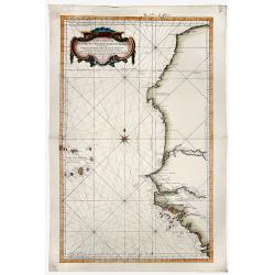
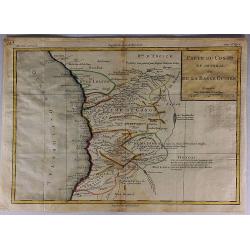
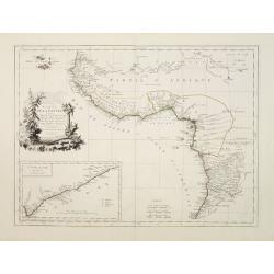
Carte Reduite DES COSTES OCCIDENTALES D' AFRIQUE Second fouille Depuis le Cap Bojador jusqu'a a la Riviere de Sierra Leona...
A beautiful map of the western coast of Africa. The map was published out of Paris by the Department de la Marine in 1765. This scarce sea chart covers the western coast ...
Date: Paris, 1753
Selling price: ????
Please login to see price!
Sold in 2019
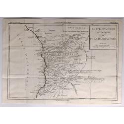
Carte Reduite DES COSTES OCCIDENTALES D' AFRIQUE Premiere fouille contenant, Les Costes de Barbarie. . .
A beautiful map of the north western coast of Africa. The map was published out of Paris by the Department de la Marine in 1765. This scarce sea chart covers the north we...
Date: Paris, 1753
Selling price: ????
Please login to see price!
Sold in 2019
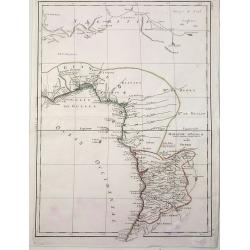
Carte De La Coste Occidentale D'Afrique Depuis le XII Dégré de Latitude Septentrionale Jusqu'au XI Dégré de Latitude Meridionale.
Very detailed map of Africa's western coast from Sierra Leone across to the Grain, Ivory, Gold and Slave coasts and Nigeria & the Gulf of Guinea. From thence the coas...
Date: Paris, 1754
Selling price: ????
Please login to see price!
Sold in 2012
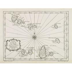
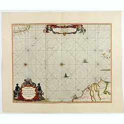
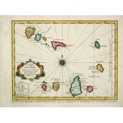
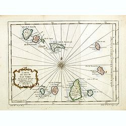
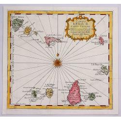
Carte des isles du Cap Verd..
This is one of the more detailed maps of the Cape Verde Islands of its time. The major settlements as well as topographical aspects are shown. A decorative wind rose near...
Date: Paris, 1754
Selling price: ????
Please login to see price!
Sold in 2008
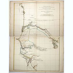
Carte de la Coste d' Angola Depuis la Riviere de Bengo jusqu'a Quanza.
Jaques Nicolas Bellin (1702-720) was the most important French hydrographer of the 18th century. Sea-atlas 'Hydrographique Français' , 1756-65, atlas to accompany Prévo...
Date: Paris, c. 1755
Selling price: ????
Please login to see price!
Sold in 2018
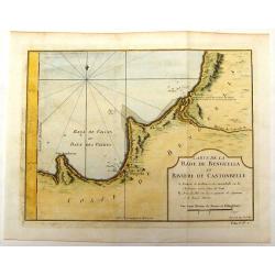
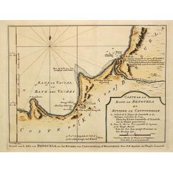
Carte de la Rade de Benguella et Riviere de Cantonbelle.
Detailed map of the region of West Africa between Angola and Catumbela. Fort Kabuto is pointed out as probably being founded by the English.
Date: Paris, 1757
Selling price: ????
Please login to see price!
Sold in 2016
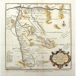
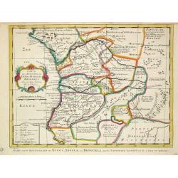
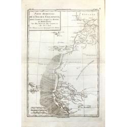
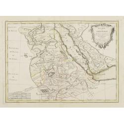
Carte du Cours des Rivieres de Falemeet Sanaga Dans les Pays de Bamucet Tamba Awra.
Interesting original map of western Mali with the Senegal and Niger Rivers showing the important Bambuk region. This is the area that has Cameroon gold mining. Engraved b...
Date: Paris, 1757
Selling price: ????
Please login to see price!
Sold in 2018
Carte De la Coste Orientale d' Afrique.
Jaques Nicolas Bellin (1702-720) was the most important French hydrographer of the 18th century. Sea-atlas 'Hydrographique Français' , 1756-65, atlas to accompany Prévo...
Date: Amsterdam, c. 1760
Selling price: ????
Please login to see price!
Sold in 2008
Carte des Isles du Cap Verde.
Jaques Nicolas Bellin (1702-720) was the most important French hydrographer of the 18th century. Sea-atlas 'Hydrographique Français' , 1756-65, atlas to accompany Prévo...
Date: Amsterdam, c. 1760
Selling price: ????
Please login to see price!
Sold
Carte . . . Congo, Angola et Benguela.
A map of the Congo and Angola as far south as Cape Negro.
Date: Amsterdam, c. 1760
Selling price: ????
Please login to see price!
Sold in 2009
Plan de l' Isle de Gorée, sur les desseins du Sr. Compagnon.
Jan van Schley is the engraver of the maps (by J.N. Bellin) and views in the Dutch edition of A.F. Prévost d' Exile's 'Histoire Géneral des Voyages'.A plan of the islan...
Date: Amsterdam, c. 1760
Selling price: ????
Please login to see price!
Sold in 2018
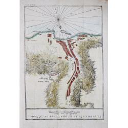
Plan de la Ville et des Forts de St. Jago
Jan van Schley is the engraver of the maps (by J.N. Bellin) and views in the Dutch edition of A.F. Prévost d' Exile's 'Histoire Géneral des Voyages'.Plan of the town an...
Date: Amsterdam, c. 1760
Selling price: ????
Please login to see price!
Sold in 2018
Carte de l' Entree de la Riviere de Sanaga ou Senegal.
Jaques Nicolas Bellin (1702-720) was the most important French hydrographer of the 18th century. Sea-atlas 'Hydrographique Français' , 1756-65, atlas to accompany Prévo...
Date: Amsterdam, c. 1760
Selling price: ????
Please login to see price!
Sold in 2018
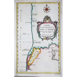
Carte d' une partie de la Coste d' Afrique Depuis Tanit jusq'a la Riviere de Senegal.
Jaques Nicolas Bellin (1702-720) was the most important French hydrographer of the 18th century. Sea-atlas 'Hydrographique Français' , 1756-65, atlas to accompany Prévo...
Date: Paris, c. 1760
Selling price: ????
Please login to see price!
Sold in 2018
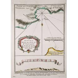
Plan de la Baye de l' Isles de St. Vincent / Vue de l' Isles de St. Vincent.
Jaques Nicolas Bellin (1702-720) was the most important French hydrographer of the 18th century. Sea-atlas 'Hydrographique Français' , 1756-65, atlas to accompany Prévo...
Date: Amsterdam, c. 1760
Selling price: ????
Please login to see price!
Sold in 2018
A New & Correct Map of Negroland and Guinea, by G.Rollos Geogr.
A detailed copper engraved map of West Africa published in Fenning's ‘A New System of Geography’.
Date: London, 1760
Selling price: ????
Please login to see price!
Sold in 2018
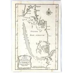
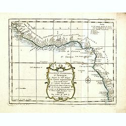
Carte de la Coste Occidentale D'Africa Depuis le Cap Blanc Jusqu'a Tanit
This map depicts the west coast of Africa along Mauritania, detailing the area around the Bay of Arguin.Islands, capes, and important towns surrounding the bay are labele...
Date: Paris, 1760
Selling price: ????
Please login to see price!
Sold in 2017
Carte du Congo en General ou de la Basse Guinnee.
A detailed map of the west coast of Africa, from Gabon to Namibia, and featuring the Congo. With detail and notations concerning recent explorations. Title in a plain blo...
Date: Paris, 1760
Selling price: ????
Please login to see price!
Sold in 2017
Carte du Congo en General ou de la Basse Guinee.
A detailed map of the west coast of Africa, from The Gabon to Namibia. Filled with detail and notations concerning recent explorations. Title in block style.Louis Brion d...
Date: Paris, 1760
Selling price: ????
Please login to see price!
Sold in 2017
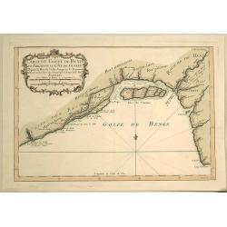
Carte du Golfe de Benin et Parte de la Cote de Guinee.
Attractive map of the infamous Slave Coast and the mouth of the Congo River showing soundings, anchorages and good coastal detail. The map features many place names, inc...
Date: Paris, 1760
Selling price: ????
Please login to see price!
Sold in 2019
Carte particuliere de la Cote Occidnetale de L'Afrique.
Very large two-piece map of the West African coast from Cap de Verga to Cap Blanc. High detail along coast and main rivers. (Gambia & Senegal)Jean Baptiste d'Anville ...
Date: Paris, 1761
Selling price: ????
Please login to see price!
Sold in 2016
A Large Chart of the Coast of Guinea From Sherbro To Cape Lopas
A large coastal sea chart with rhumb lines of mainly the Gold Coast, by Francis Lamb, published in 'The English Pilot, part V, 6th edition', London, Mount and Page, 1761....
Date: London, 1761
Selling price: ????
Please login to see price!
Sold in 2022
Carte des Costes de Guinée.
A very rare map of western part of Africa with the Ivory coast, from Le Commerce de l'Amérique par Marseille, ou Explication des Lettres-Patentes du Roi, portant Regleme...
Date: Avignon 1764
Selling price: ????
Please login to see price!
Sold
Carte de L'Entree de la Riviere de Sanaga ou Senegal.
The Sanaga River is a river of South Province, Cameroon. The map was published in 1764 by Nicholas Bellin in Paris.
Date: Paris, 1764
Selling price: ????
Please login to see price!
Sold in 2016
Carte de la Riviere de Kalbar...
A detailed coastal map of this Guinea coast area of Western Africa, based upon the 1699 voyage of James Barbot & John Grazilhier to New Kalabar, Bandi, and Doni River...
Date: Paris, 1764
Selling price: ????
Please login to see price!
Sold in 2018
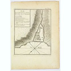
Plan de la Forteresse et Bourg, de Lisle de Ste. Helene.
A plan of the Fortress and Borough on the island of St. Helena by Bellin. With an inset legend of several important items and places of note, including the Govenor's hous...
Date: Paris, 1764
Selling price: ????
Please login to see price!
Sold in 2021
Partie de la Coste de Guinee.
A detailed map of the Guinea coast in West Africa, from the Sierra Leone River to Cape Palmas on the southern coast of what is now Liberia, from the atlas of Prevost d'Ex...
Date: Paris, 1764
Selling price: ????
Please login to see price!
Sold in 2019
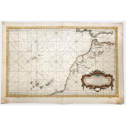
Carte Reduite des Costes Occidentales d'Afrique seconde feuille depuis le Cap Bojador jusqu'a la Riviere de Sierra Leona pour le service des Vaisseaux du Roy... Seconde feuille..
Sea chart of the West African coast, from Sierra Leone to southern Morocco, and including the Cape Verde Islands and part of the Canaries, all at a scale of about 1:3,000...
Date: Paris 1754 corrected in 1765
Selling price: ????
Please login to see price!
Sold
Carte de la Riviere de Kalbar.
A splendid coastal map of this Guinea coast area of Western Africa, the chart is based upon the 1699 voyage of James Barbot & John Grazilhier to New Kalabar, Bandi, a...
Date: Paris, 1765
Selling price: ????
Please login to see price!
Sold in 2016
Carte Reduite des Costes Occidentales d'Afrique seconde feuille depuis le Cap Bojador jusqu'a la Riviere de Sierra Leona pour le service des Vaisseaux du Roy... Seconde feuille..
Sea chart of the West African coast, from Sierra Leone to southern Morocco, and including the Cape Verde Islands and part of the Canaries, all at a scale of about 1:3,000...
Date: Paris, 1753 corrected in 1765
Selling price: ????
Please login to see price!
Sold in 2018
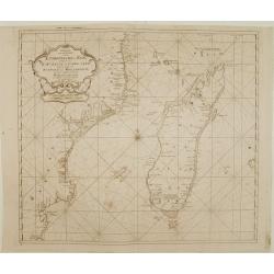
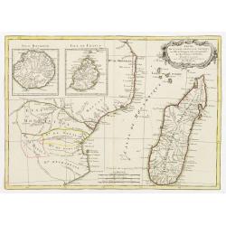
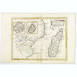
Carte de L'Isle de Madagascar. . .
A fine early sea chart of the African island of Madagascar, published by the French Hydrographical Department. An attractive large-scale chart full of interesting topogra...
Date: Paris, 1765
Selling price: ????
Please login to see price!
Sold in 2019
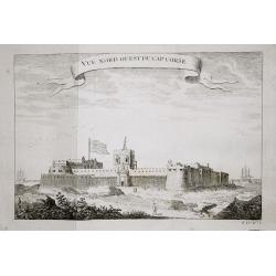
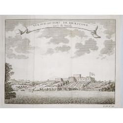
Vue nord ouest du Cap Corse.
The English fortresses at Cape Corse.From a French edition of Prévost d' Exile's ' Histoire. des Voyages', 1738-75.
Date: Paris, 1769
Selling price: ????
Please login to see price!
Sold in 2018
Plan of the English fortresses at Dickscove Vue du sud du fort de Dickscove.
The English fortresses at Dickscove.From a French edition of Prévost d' Exile's ' Histoire. des Voyages', 1738-75.
Date: Paris, 1769
Selling price: ????
Please login to see price!
Sold in 2020
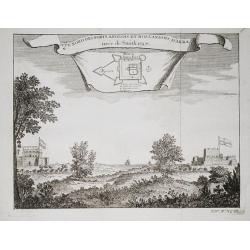
Vue nord des forts anglois et Hollandois d'Akra.
The Dutch and English forts at Accra. From a French edition of Prévost d' Exile's "Histoire des Voyages", 1738-1775. Crevecoeur, the Dutch fort and the English...
Date: Paris, 1769
Selling price: ????
Please login to see price!
Sold in 2018
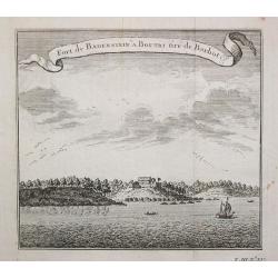
Fort de Badenstein a Boutri.
Fortress Badenstein at Boutri.From a French edition of Prévost d' Exile's ' Histoire. des Voyages', 1738-75.
Date: Paris, 1769
Selling price: ????
Please login to see price!
Sold in 2018
Carte de la Riviere de Kalbar.
Detailed coastal map of the Guinea coast of West Africa based on the 1699 voyage of James Barbot and John Grazilhier to the Kalabar River. This was the heart of the slave...
Date: Amsterdam, 1770
Selling price: ????
Please login to see price!
Sold in 2015
Guinee Guinee IIe. Feuille.
An example of Bonne's 1770 decorative map of West Africa. It covers from the Gold Coast (Ghana), south around the Bight of Benin (Biafara) to Gabon, Congo and Angola. It...
Date: Paris, 1770
Selling price: ????
Please login to see price!
Sold in 2022
Carte de la Guinee, contenant les Isles du Cap Verd, le Senegal, la Cote de Guinee proprement dite, les Royaumes de Loango, Congo, Angola et Benguela....
A map of the Gulf of Guinea by Jean Lattré, a Paris-based engraver and publisher. He worked with Robert de Vaugondy, J. Janvier and R. Bonne. From his "Atlas Modern...
Date: Paris, 1771
Selling price: ????
Please login to see price!
Sold in 2017
Partie Occidentale de L'Ancien Continent depuis Lisbonne Jusqu'a la Riviere de Sierra Leona.
Fine copper engraved map featuring the west coast of northern Africa and the Madiera, Canary and Cape Verde Island groups. Engraved by Dien for R. Bonne's "RAYNAL'S ...
Date: Paris, 1774
Selling price: ????
Please login to see price!
Sold in 2016
Carte de la Haute et de la Basse Guinee.
Fine copper engraved map featuring the west coast of northern Africa from The Sierra Leone River to Cape Negro. Engraved by Dien for R. Bonne's "RAYNAL'S HISTOIRE PH...
Date: Paris, 1774
Selling price: ????
Please login to see price!
Sold in 2016
Guinee Entre Serre-Lione et le Passage de la Ligne.
Copper engraved map of the coast of the West African country of Guinee between Serre-Leone and the Equator. This was one of the top sources of slaves during the Historica...
Date: Paris, 1775
Selling price: ????
Please login to see price!
Sold in 2014
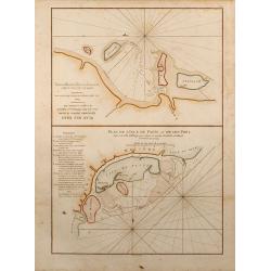
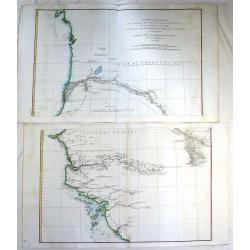
Plan de l'Isle de Patte et de son Port / Plan des Isles Querimbo, Oybo et Matemo.
Two finely colored sea charts of the coast of Africa on one sheet. Showing several Islands at the coast of Kenya and Mozambique. From the second revised and enlarged edit...
Date: Paris, 1775
Selling price: ????
Please login to see price!
Sold in 2015
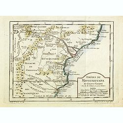
Empire du Monomotapa et Etats Voisins. . .
A small interesting map of the Kingdom of Monomotapa roughly in today's Mozambique. Based on Delisle, it includes the Zambeze River.Prepared by Jacques Nicolas Bellin and...
Date: Paris, 1738-1775
Selling price: ????
Please login to see price!
Sold in 2014
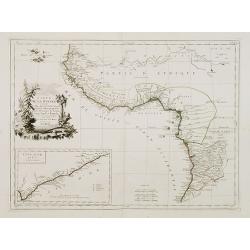
Coste occidentale d'Afrique depuis le Détroit de Gibraltar.
An interesting map of the North-West coast of Africa, from the Straits of Gibraltar to the Gambia River and Cachau. The detailed map includes the Canary Islands, Madeira,...
Date: Paris, 1738-1775
Selling price: ????
Please login to see price!
Sold in 2016
Carte des Isles du Cap Verd.
An interesting map of the islands of the Cap Verd.Prepared by Jacques Nicolas Bellin after Dutch sources and included in Prévost d' Exile's "Histoire des Voyages&qu...
Date: Paris, 1738-1775
Selling price: ????
Please login to see price!
Sold in 2016
Carte des Royaumes de Congo, Angola et Benguela, avec les Pays voisins.
An interesting map of the kingdoms of Congo, angola and Benguela .Prepared by Jacques Nicolas Bellin after Dutch sources and included in Prévost d' Exile's "Histoir...
Date: Paris, 1738-1775
Selling price: ????
Please login to see price!
Sold in 2014
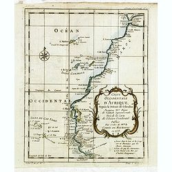
Carte de la Coste occidentale d'Afrique.
An interesting map of the West Coast of Equatorial Africa, from the Rio Grande in Senegal to just south of Angola .Prepared by Jacques Nicolas Bellin after Dutch sources ...
Date: Paris, 1738-1775
Selling price: ????
Please login to see price!
Sold in 2018
Carte de la Guinée contenant les Isles du Cap Verd le Senegal, la Côtede Guinée proprement dite les Royaumes de Loango, Congo..
Detailed map of Southwest African coast, from Guinea to Congo.Santini gives credit to R.Bonne in the cartouche. With inset map of the "Gold Coast" after d'Anvil...
Date: Venise 1776
Selling price: ????
Please login to see price!
Sold
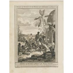
Negres de Kachao et de Bissao qui preparent le Manioc. (Brissau)
Engraving depict a typical scene of Africa, from "Histoire des Voyages..", by Prevost. Below title in Dutch "Negers van Kachao en Bissao, die Manioc bereid...
Date: Paris, Didot, ca. 1780
Selling price: ????
Please login to see price!
Sold in 2015
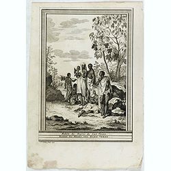
Guiriot ou negre jouant du balafo.
Engraving depict a typical scene of Africa, from "Histoire des Voyages..", by Prevost. Based on Barbot, showing a Griot or Negro playing the balafon on top, ins...
Date: Paris, Didot, ca. 1780
Selling price: ????
Please login to see price!
Sold in 2015
Partie Occidentale de L'Ancien Continent.
"Western part of the old continent, from Lisbon to the river Sierra Leona, etc." Antique map from the "Atlas de Toutes les Parties Connues du Globe Terrest...
Date: Paris, 1780
Selling price: ????
Please login to see price!
Sold in 2017
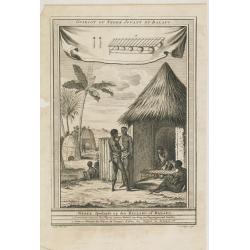
Habits des Negres du Cap Verd. / Kleedy der Negers aan Kabo Verde.
Inhabitants of Cape Verde.
Date: Paris, Didot, ca. 1780
Selling price: ????
Please login to see price!
Sold in 2017
Carte de la Haute et de la Basse Guinee Depuis la Riviere de Sierra Leona Jus qu' au Cap Negro.
A fine map of Africa's Guinea coast by Rigobert Bonne and G. Raynal's in 1780. The map corresponds to modern day Liberia, Ivory Coast, Ghana, Nigeria, Cameroon, Gabon, Co...
Date: Paris, 1780
Selling price: ????
Please login to see price!
Sold in 2017
Carte de la Haute et de la Basse Guinee.
An engraved map showing the entire Guinea coast from the Sierra Leone River to Cape Negro. Locates many towns and villages, lakes and coastal features. Today this is Libe...
Date: Paris, 1780
Selling price: ????
Please login to see price!
Sold in 2019
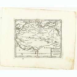
Barbaria, Egitto, Nigrizia, Guinea, Nubia Abissina.
Rare map of the northern half of Africa, from "Atlante Novissimo ad uso Dei Giovani Studiosi Contenuto In Carte XXVII.", published by Giovanni Zempel in Rome, c...
Date: Rome, 1780
Selling price: ????
Please login to see price!
Sold in 2021
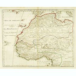
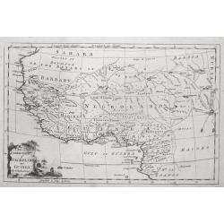
Carte de la Barbarie de la Nigritie et de la Guinée. . .
Detailed engraved map of north west Africa including the Canary and Cape Verde Islands. The title is displayed along the top of the map. In this map De L'Isle corrects hi...
Date: Paris, 1781
Selling price: ????
Please login to see price!
Sold in 2015
Carta Dell Coste Della Guinea Dal Capo di Verga Sino al Paese d'Issini.
A fine copperplate map of Sierra Leone, including Liberia and the Ivory Coast, from the Italian edition by D’Anville. It features a decorative Rococo cartouche. Jean Ba...
Date: Paris, 1781
Selling price: ????
Please login to see price!
Sold in 2018
Carta dell Isole di Capo Verde.
A pleasant little map of the Cape Verde Islands off the coast of Africa, by Bellin in Paris dated 1781. This map is from the Italian edition. It features an attractive ti...
Date: Paris, 1781
Selling price: ????
Please login to see price!
Sold in 2017
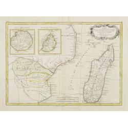
Partie de la Cote Orientale d' Afrique avec l' Isle de Madagascar et les Cartes particulières des Isles de France et de Bourbon..
A map of the south eastern coast of Africa and the island of Madagascar, comprehending 2 insets of the island of Bourbon (today Reunion) and Mauritius.From the Atlas mode...
Date: Paris ca 1783
Selling price: ????
Please login to see price!
Sold
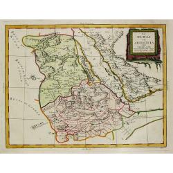
Nubie et Abissinie..
Attractive map showing today Ethiopia and Eritrea. Ornated with a decorative title cartouche. Boundaries outlined in hand color.From theAtlas moderne ou collection de car...
Date: Paris, ca 1783
Selling price: ????
Please login to see price!
Sold
Partie de la Cote Orientale D'Afrique avec l'Isle de Madagascar.. Isles de France et de Bourbon..
Attractive map of part of South Africa, including Madagascar and 2 insets with the Reunion and Mauritius Islands.Ornated with a decorative title cartouche. Boundaries out...
Date: Paris, ca 1783
Selling price: ????
Please login to see price!
Sold
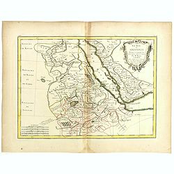
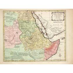
Nubie et Abissinie . . .
Attractive map of East Africa, ornated with a decorative title cartouche. Boundaries outlined in hand color.Prepared by Le Sieur Janvier, Jean Denis [Robert], French geog...
Date: Paris, ca 1783
Selling price: ????
Please login to see price!
Sold in 2019
![[Two maps] Carte de la Guinée contenant les Isles du Cap Verd, le Senegal, la Côte de la Guinée proprement dite, les Royaumes de Loango, Congo, Angola, Benguela . . .](/uploads/cache/42837-250x250.jpg)
[Two maps] Carte de la Guinée contenant les Isles du Cap Verd, le Senegal, la Côte de la Guinée proprement dite, les Royaumes de Loango, Congo, Angola, Benguela . . .
Attractive map of the African west Coast, with Cap Verde island, ornated with a decorative title cartouche. Boundaries outlined in hand color.Prepared by Le Sieur Janvier...
Date: Paris, ca 1783
Selling price: ????
Please login to see price!
Sold in 2019
Carte de la Guinée contenant les Isles du Cap Verd, le Senegal, la Côte de Guinée proprement dite, les Royaumes de Loango, Congo..
Detailed map of Southwest African coast, from Guinea to Congo.Santini gives credit to R.Bonne in the cartouche. With inset map of the "Gold Coast" after d'Anvil...
Date: Venice, 1776 - 1784
Selling price: ????
Please login to see price!
Sold in 2018
Parte della Costa a Orientale dell'Africa con I'Isola di Madagascar e le Carte particolari dell'Isole di Francia e di Borbon.
An uncommon map of Madagascar with inset maps of the islands of Bourbon and Francia. Mauritius. Embellished with a nice 'scroll' title-cartouche.
Date: Venice, 1784
Selling price: ????
Please login to see price!
Sold in 2018
La Nubia et Abissinia.
An antique map of East Africa: La Nubia et Abissinia by Antonio Zatta, (fl. 1757-1797). Zatta was a Venetian publisher. Published in his atlas of 4 volumes 'Atlante novis...
Date: Venice, 1784
Selling price: ????
Please login to see price!
Sold in 2019
Nubie et Abissinie.
Willem Albert Bachiene (1712-1783), Dutch geographer in Maastricht. Most important work ' Heilige Geographie', a work on the Holy Land. Mathijs Schalenkamp published in 1...
Date: Amsterdam, 1785
Selling price: ????
Please login to see price!
Sold
