Browse Listings in Africa > Central Africa > East coast
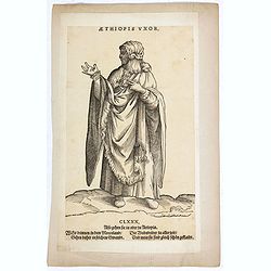
Aethiopis Vxor. (CLXXX)
A African woman standing with floor-length dress. Woodcut by Jost Amman after Weigel. From H. Weigel, "Trachtenbuch". - "The woodcuts have ... above Latin ...
Date: Cologne, ca. 1577
Selling price: ????
Please login to see price!
Sold in 2019
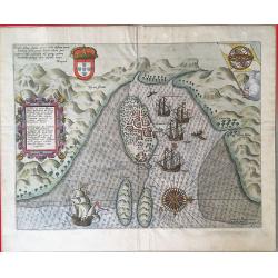
Insulae et arcis Mocambique descriptio ad fines Melinde.
An attractive and rare bird's-eye view of Melinde harbour in Mozambique, engraved by Jan Deutecum for Linschoten's 'Itinerario', published between 1596 and 1644. Probably...
Date: Amstrerdam, 1596
Selling price: ????
Please login to see price!
Sold in 2020
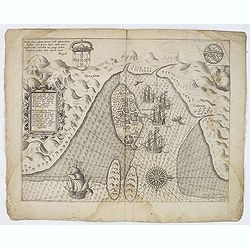
Insulae et arcis MOCAMBIQUE descriptio...Beschrijuinge des..
This is a finely executed copperplate engraved map of Mozambique Island, a strategically important re-supply point for the Portuguese empire in Asia during the 16th centu...
Date: Amsterdam, 1596
Selling price: ????
Please login to see price!
Sold in 2013
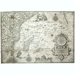
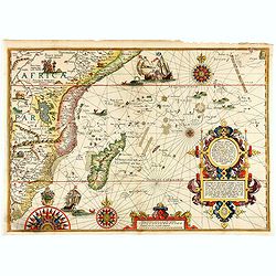
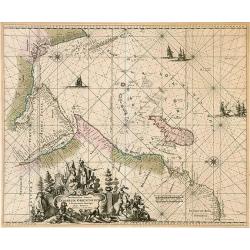
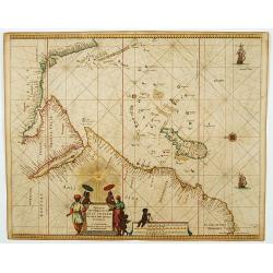
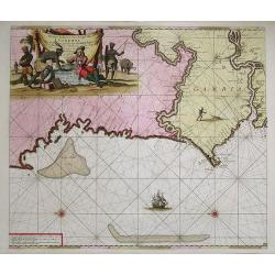
Affbeeldinghe der custen des landts...Terra do Natal.
A superbly decorative early chart engraved by Arnold van Langren showing the African coastline of the Indian Ocean from the Cape to Natal, Mozambique and Madagascar. From...
Date: Amsterdam, 1598
Selling price: ????
Please login to see price!
Sold in 2011
Delineatio orarum maritimarum, terræ vulgo indigetatæ terræ do Natal, item Sofalæ, Mozambicæ & Melindæ, insulæque Sancti Laurentii. . . / Affbeeldinghe der custen des landts genaempt terra do Natal, item van alle de custen van Coffala, Mozambique. .
A superbly decorative early chart engraved by Arnold van Langren showing the African coastline of the Indian Ocean from the Cape to Natal, Mozambique and Madagascar. Tool...
Date: Amsterdam, 1598
Selling price: ????
Please login to see price!
Sold in 2020
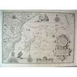
Affbeeldinghe der custen des landts...Terra do Natal.
A superbly decorative early chart engraved by Arnold van Langren showing the African coastline of the Indian Ocean from the Cape to Natal, Mozambique and Madagascar. From...
Date: Amsterdam 1598
Selling price: ????
Please login to see price!
Sold
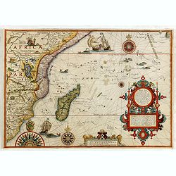
Affbeeldinghe der custen des landts. . .Terra do Natal.
A superbly decorative early chart engraved by Arnold van Langren showing the African coastline of the Indian Ocean from the Cape to Natal, Mozambique and Madagascar. From...
Date: Amsterdam, 1598
Selling price: ????
Please login to see price!
Sold in 2015
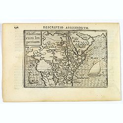
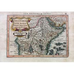
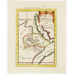
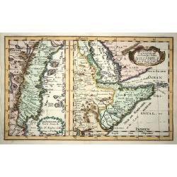
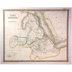
Abissinorum Imperium.
A fine miniature map of the "Empire of Abyssinia", home to the mythical Christian king, Prester John, published by Petrus Bertius in Amsterdam early in the seve...
Date: Amsterdam, 1606
Selling price: ????
Please login to see price!
Sold in 2019
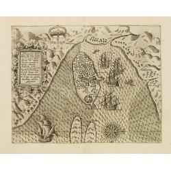
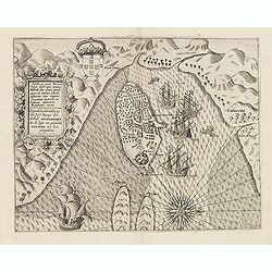
Insulae & Ars Mosambique.
An very attractive miniature map of the Portuguese island of Mozambique in east Africa, published by Petrus Bertius, in Amsterdam at the beginning of the seventeenth cent...
Date: Amsterdam, 1606
Selling price: ????
Please login to see price!
Sold in 2023
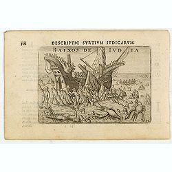
Baixos de Iudia.
Early miniature view of a shipwreck on the islands located between Madagascar and Mozambique. In the foreground, a kind of big lobsters are catching shipwrecked passenger...
Date: Amsterdam, Cornelis Claes, 1606
Selling price: ????
Please login to see price!
Sold in 2020
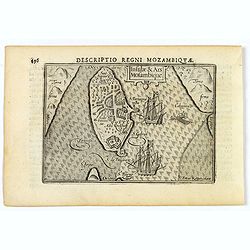
Insulae et arcis Mocambique descriptio ad fines Melinde sita ebano puriss
Attractive bird's-eye view of Melinde harbor in Mozambique showing the fortifications with numerous ships at anchor in the protected harbor. The map is finely engraved an...
Date: Frankfurt 1607
Selling price: ????
Please login to see price!
Sold
Insulae et arcis Mocambique descriptio ad fines Melinde sita ebano puriss.
Attractive bird's-eye view of Melinde harbor in Mozambique showing the fortifications with numerous ships at anchor in the protected harbor. The map is finely engraved an...
Date: Frankfurt, 1607
Selling price: ????
Please login to see price!
Sold in 2025
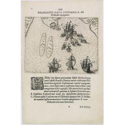
Delineatio Navis Lusitanicae ab Hollandis expugnatae.
A Dutch fleet arriving at Mozambique. Engraved by G.KellerTheodore de Bry, a German engraver and book dealer, began a compilation of early voyages in 1590 and had publish...
Date: Frankfurt, 1609
Selling price: ????
Please login to see price!
Sold in 2011
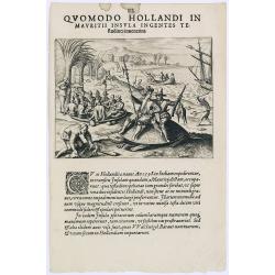
Quomodo Hollandi in Mavritii Insula Ingentes. (Dutch hunting parrots on Mauritius in 1598)
A picture of giant tortoises in Mauritius. In the background Dutch hunting parrots. The Dutch abandoned Mauritius after two unsuccessful attempts to colonize the island. ...
Date: Frankfurt, 1609
Selling price: ????
Please login to see price!
Sold in 2013
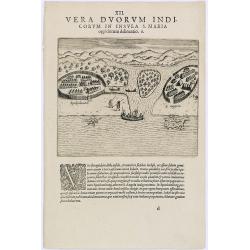
Vera Duorum Indicorum in insula S. Maria.
Showing the village of St. Angela and Spakenburg on Madagascar.Theodore de Bry, a German engraver and book dealer, began a compilation of early voyages in 1590 and had pu...
Date: Frankfurt, 1609
Selling price: ????
Please login to see price!
Sold in 2023
Abissinorum sive Pretiosi Ioannis Inperiu / Coni Regni in Africa Christiani Nova descriptio.
Gerard Mercator's ' Atlas sive Cosmographica' was published and augmented between 1606 and 1641 by Jodocus Hondius, his son Hendrik and by Johannes Janssonius.A very deco...
Date: Amsterdam, 1609
Selling price: ????
Please login to see price!
Sold in 2014
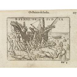
Baixos de Iudia.
Early miniature view of a shipwreck on the islands located between Madagascar and Mozambique. In the foreground, a kind of big lobsters are catching shipwrecked passenger...
Date: Amsterdam / Frankfurt, 1609
Selling price: ????
Please login to see price!
Sold in 2009
Mauritius.
From J.A.Pontanus\' \'Rerum et urbis Amstelodamensium historia\'. Description of the first voyage of the Dutch to the East Indies under command of Houtman.
Date: Amsterdam, 1611
Selling price: ????
Please login to see price!
Sold
Abissinorum Sive Pretiosi Ioannis Imperium
A single page map of central and eastern Africa. This map depicts the mythical Christian kingdom of 'Prester John' on the African continent. Based on Mercator/ Hondius.
Date: Amsterdam, 1628
Selling price: ????
Please login to see price!
Sold in 2018
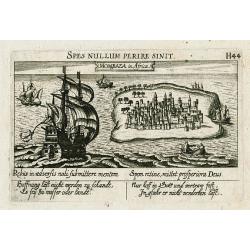
Mombaza in Africa.
Early and important copper engraved view of the former Portugese colony Mombasa on Mombasa Island, in present day Kenya. Showing a large and beautifully illustrated saili...
Date: Frankfurt , c 1630
Selling price: ????
Please login to see price!
Sold in 2011
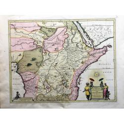
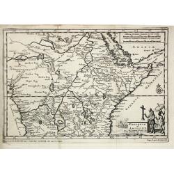
Aethiopia Superior vel Interior vulgo Abissinorum...
Offered is a large, decorative, attractive map of Eastern African and the fictitious kingdom of Prester John. The map shows a major section of central and eastern Africa,...
Date: Amsterdam, 1640
Selling price: ????
Please login to see price!
Sold in 2023
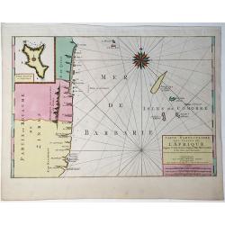
Occidentalior Tractus Indiarum Orientalium à Promotorio Bonae Spei ad C. Comorin.
Rare sea chart by Ottens of showing the coastlines of the Arabian peninsula and Africa up to Cape Town, with a splendid cartouche of royal figures and animals.
Date: Amsterdam, 1645
Selling price: ????
Please login to see price!
Sold in 2009
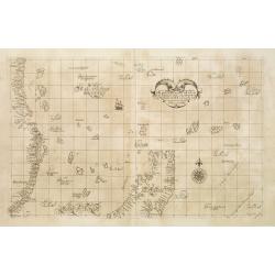
Carta Particolare della parte Tramontana dell Isola di San Lorenzo con la costa diripetto sino à Monbazza con l'Isole è Seccagne int.. Carta XIII I.
First state of Dudley?s magnificent chart showing the east coast of Africa including the northern half of Madagascar. Include a sailing ship, compass card, notes on preva...
Date: Florence 1645
Selling price: ????
Please login to see price!
Sold
Carta particolare che mostra il Capo buona Speranza con il mare....
The rare first state in a beautiful example.
Date: Florence, 1646
Selling price: ????
Please login to see price!
Sold
Pascaerte van 't Westelyckste Deel van Oost Indien, van Cabo de Bona Esperanca tot C.Comorin..
An eye-catching of the western part of the Indian Ocean and its adjacent coasts of East Africa, Arabia with the Red Sea and the Arabian Gulf, Iran, Pakistan and western ...
Date: Amsterdam, 1666
Selling price: ????
Please login to see price!
Sold in 2009
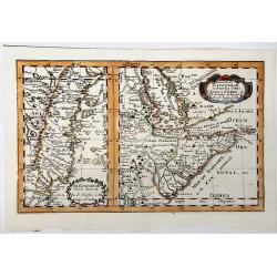
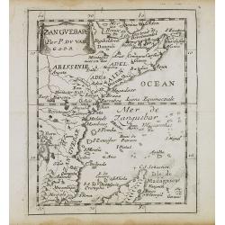
Partie du ZANGUEBAR ou Sont les Costes d'AJAN et d' ABEX &c.
Two, maps on one sheet showing the coasts of East Africa. The left hand map shows the Zanzibar coast, the right hand map shows the coast north from Zanzibar, round the Ho...
Date: Paris, P. Mariette, 1667
Selling price: ????
Please login to see price!
Sold in 2019
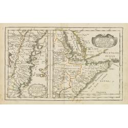
Le Zanguebar Partie du Zanguebar ou sont les Costes d'AJAN et d'ABEX.
Two maps on one sheet showing the coasts of East Africa. The left hand map shows the Zanzibar coast, the right hand map shows the coast north from Zanzibar, round the Hor...
Date: Paris, P. Mariette, 1667
Selling price: ????
Please login to see price!
Sold in 2008
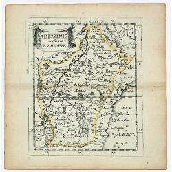
ABISSINIE ou Haute ETHIOPIE.
Nubie old, outlined colored historical miniature map of Abyssinie in north Ethiopia. The map is copperplate engraved with hand coloring and in very good condition and pu...
Date: Paris 1670
Selling price: ????
Please login to see price!
Sold in 2020
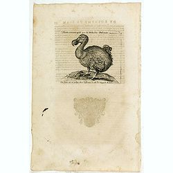
Dronte, autrement appellé par les Hollandois Dod-aers.
An early text engraving of a Dodo who Willem Ysbrandtszoon Bontekoe claimed to have seen on Réunion and published from 1672 onwards in "Relations de Divers Voyages ...
Date: Paris, 1672
Selling price: ????
Please login to see price!
Sold in 2015
Joao Teixeira Cosographo de sua Magestade.
An early issue of this important map of the Indian Ocean was prepared by Joao Teixeira, a well-known and respected Portuguese chart maker. He produced this wonderful sea ...
Date: Paris ca. 1672
Selling price: ????
Please login to see price!
Sold in 2017
Dronte Alijs Dod-Aers.
An early text engraving of a Dodo who Willem Ysbrandtszoon Bontekoe claimed to have seen on Réunion and published from 1672 onwards in "Relations de Divers Voyages ...
Date: Paris, 1672
Selling price: ????
Please login to see price!
Sold in 2015
Zanguebar.
Uncommon miniature map of East Africa including Northern tip of Madagascar, from Pierre Duval's La Geographie Universeille. Following his Cartes de geographie in 1657, Pi...
Date: Paris, 1676
Selling price: ????
Please login to see price!
Sold in 2008
Nieuwe Paskaert, Van de Kust Van Genehoa als Medeen gedeelte van Gambia, beginnende an C. Blanco tot C. Verde, Met al syn diep ten end droogten, dus Ver Naeukeurig op gestelt.
Nice chart, showing the coast of Africa, from Cabo Blanco till Cabo Verde (Dakar) and Gambia River. The Dutch firm and printing house van Keulen was one of the most impor...
Date: Amsterdam, 1684
Selling price: ????
Please login to see price!
Sold in 2009
Empire des Abyssins. . .
A charming map of he Abyssinian Empire referred to as Nubia with a colorful title banner.German title in curtain draped at top. No text on verso.From the German text edit...
Date: Frankfurt, 1684
Selling price: ????
Please login to see price!
Sold in 2012
![I. Goree [Ialoffes Royaume]](/uploads/cache/25317-250x250.jpg)
I. Goree [Ialoffes Royaume]
A charming map featuring a bird's eye view of Island of Goree with hills, dwellings and trees on the island, four ships at sea heading towards the island, and coastal Ara...
Date: Franckfurt, 1684
Selling price: ????
Please login to see price!
Sold in 2008
![Isle de Zocotora [Die Insel Zocotora]](/uploads/cache/25316-250x250.jpg)
Isle de Zocotora [Die Insel Zocotora]
A charming map featuring a bird's eye view of Socotra with hills, dwellings and trees on the island, two naval battles with cannons firing at sea, and coastal Arabia and ...
Date: Frankfurt, 1684
Selling price: ????
Please login to see price!
Sold in 2008
Abissinia, doue sono le Fonti del Nilo..
This very uncommon map concentrates of the source of the Nile in a lake called Tzana, Dembea, which Coronelli claimed to be the first to accurately depict.Extensive notat...
Date: Venice 1690
Selling price: ????
Please login to see price!
Sold
Abissinia, doue sono le Fonti del Nilo.
This very uncommon map concentrates of the source of the Blue Nile in a lake called Tzana, Dembea, which Coronelli claimed to be the first to accurately depict.Extensive ...
Date: Venice, 1690
Selling price: ????
Please login to see price!
Sold in 2018
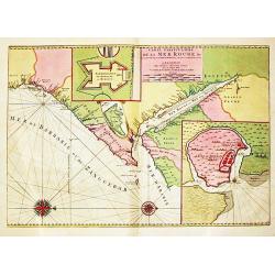
Carte Particuliere de la Mer Rouge &c.
An attractive sea chart of the Red Sea, Africa's Indian ocean coast from the Red Sea to Mozambique and the southwest coast of Arabia. With insets of Mombassa and fort and...
Date: Amsterdam, 1700
Selling price: ????
Please login to see price!
Sold in 2020
Pas caerte vande Custen van Loango, Angoy als mede en gedeelte van Angola, van C. de Lopa Goncalves, tot aen R. de Zaire.
Sea-chart of the coast of Loango.Latitude scale, compass rose and system of rhumb lines, soundings, anchorage's, etc.
Date: Amsterdam, ca. 1700
Selling price: ????
Please login to see price!
Sold in 2014
Partie de la HAUTE AETHIOPIE ou sont L'EMPIRE des ABISSINS et la NUBIE &c.
An excellent map of the Nile with its mythical sources. Shows the Nile River from Zaire Lake and Zaflant Lake, until Assuan / Aswan). Richly detailed with place names, hi...
Date: Paris, ca 1700
Selling price: ????
Please login to see price!
Sold in 2019
Partie de la Haute Aethiopie ...
Map of the East coast of Africa. From Description de tout l'Univers, published by François Halma.
Date: Amsterdam, 1700
Selling price: ????
Please login to see price!
Sold in 2011
Le Zanguebar Tiree de Sanut &c. / Partie du Zanguebar ou Sont les Costes d'Ajan et d'Abix &c.
This attractive map, in two parts, covers the east coast of Africa from Mozambique to the Red Sea showing the prosperous trading ports. Each map has a decorative title ca...
Date: Amsterdam, 1700
Selling price: ????
Please login to see price!
Sold in 2008
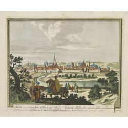
Amara, een voorname stadt midden in opper Ethiopie, Abyssine genaamt, ..
From Schenk's Hecatompolis sive Totius Terrarum Oppida Nobiliora Centrum.. , a collection of 100 views, dedicated to the 14-year old Prussian crown prince, the later king...
Date: Amsterdam, 1702
Selling price: ????
Please login to see price!
Sold in 2016
Aethiopie of Abissine. In 't gemeen 't Land van Preste Jan Genoemd.
Pieter van der Aa was a prolific publisher. He published a.o. ' Naauwkeurge versameling der gedenkwaardigste zee- en land-reysen', a series of accounts of voyages (1706-0...
Date: Leiden, 1707
Selling price: ????
Please login to see price!
Sold
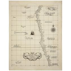
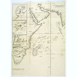
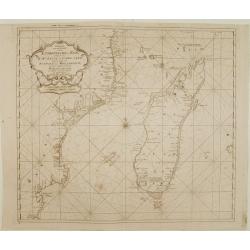
Carte Particuliere Des Costes De L'Afrique Depuis C.Del Gado Jusques Rio Mocambo.
A fine sea chart of the coasts of Mozambique and Tanzania and the Comoro Islands. Full tile: 'Carte Particuliere Des Costes De L'Afrique Depuis C.Del Gado Jusques Rio Moc...
Date: Amsterdam, 1693-1708
Selling price: ????
Please login to see price!
Sold in 2020
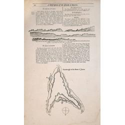
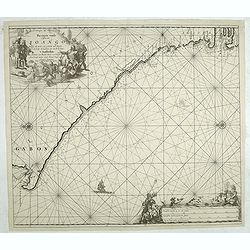
A Description of the Islands of Joanna (Anjouan).
A Description of the Islands of Joanna by Samuel Thornton. Small woodblock chart by Samuel Thornton of The Island of Joanna published in 1711 by John How and Samuel Thorn...
Date: London, 1711
Selling price: ????
Please login to see price!
Sold in 2014
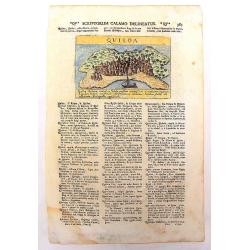
Quiloa
An uncommon, important map of Kilwa , an island off the coast of East Africa, in present day Tanzania. It is from Lazor A Varea's "Universus Terrarum Orbis". A ...
Date: Padua, 1713
Selling price: ????
Please login to see price!
Sold in 2013
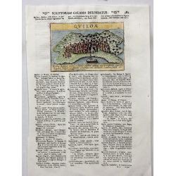
Quiloa.
A charming map of the island nation of Quiloa (Kilwa) off the coast of East Africa, in present day Tanzania near Zanzibar. An attractive small city view (after Valegio) ...
Date: Padua, 1713
Selling price: ????
Please login to see price!
Sold in 2017
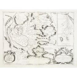
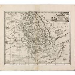
Jobi Ludolfi Habessinia seu Abassia Presbyteri Johannis ?
Jobi Ludolfus (1624-1704) was a German scholar and historian, specialising in Abyssinia (Ethiopia). His map is one of the earliest, relatively accurate maps of the region...
Date: Amsterdam, 1720
Selling price: ????
Please login to see price!
Sold in 2010
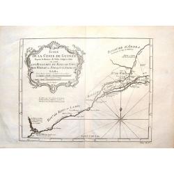
Suite de la Coste de Guinnee Deouis la Riviere de Volta Jusqu'a Jakin.
Fine detailed map of the African Guinea coast, west of the Volta River. Featuring the kingdoms of Koto, de Popo, de Whidah and Ardra.Engraved by J. Schley from atlas of P...
Date: Paris, 1747
Selling price: ????
Please login to see price!
Sold in 2015
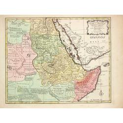
A New and Accurate Map of Nubia & Abissinia, Together with All the Kingdoms Tributary there...
Showing the area from lower Egypt, through Sudan and Ethiopia and down to Somalia. The map also includes the Red Sea and what is now Yemen and South Arabia. Blank on vers...
Date: London, 1747
Selling price: ????
Please login to see price!
Sold in 2013
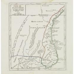
Cote de Zanguebar. . .
Nice small map showing a long stretch of the central Africa east coast. From Atlas Portatif Universel, by Robert de Vaugondy.Page 83 outside border top right. Mary Sponbe...
Date: Paris, later than 1748
Selling price: ????
Please login to see price!
Sold in 2014
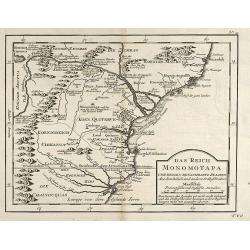
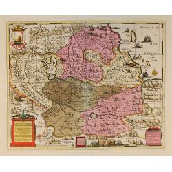
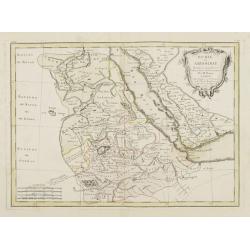
Das Reich der Monomotapa und dessen benachbarte Staaten.
Engraved map of Mozambique in Southeast Africa by Nicolas Bellin. From the German edition of Prévost's "L'Histoire Générale des Voyages" by J. J. Schwabe in ...
Date: Leipzig, 1749
Selling price: ????
Please login to see price!
Sold in 2009
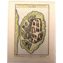
Plan de L'Isle et Ville de Quiloa.
Copper engraved plan of the fortified town of Quiloa on the east coast of Africa. This town was the center of the Portuguese slave trade.
Date: Paris, c. 1750
Selling price: ????
Please login to see price!
Sold in 2016
Paskaart van een gedeelte van de Aethiopische=Zee.. Madagascar..
Showing the island of Madagascar and the east coast of Africa. Very rare: included in 6th volume, so-called secret atlas of the V.O.C. of Van Keulen. Latitude scale, comp...
Date: Amsterdam 1753
Selling price: ????
Please login to see price!
Sold
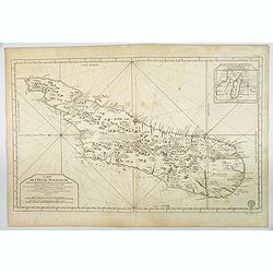
Carte de L'Isle de Madagascar. . .
A fine early sea chart of the African island of Madagascar, published by the French Hydrographical Department. An attractive large-scale chart full of interesting topogra...
Date: Paris, 1765
Selling price: ????
Please login to see price!
Sold in 2019
Partie Occidentale de L'Ancien Continent depuis Lisbonne Jusqu'a la Riviere de Sierra Leona.
Fine copper engraved map featuring the west coast of northern Africa and the Madiera, Canary and Cape Verde Island groups. Engraved by Dien for R. Bonne's "RAYNAL'S ...
Date: Paris, 1774
Selling price: ????
Please login to see price!
Sold in 2016
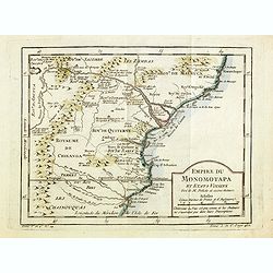
Empire du Monomotapa et Etats Voisins. . .
A small interesting map of the Kingdom of Monomotapa roughly in today's Mozambique. Based on Delisle, it includes the Zambeze River.Prepared by Jacques Nicolas Bellin and...
Date: Paris, 1738-1775
Selling price: ????
Please login to see price!
Sold in 2014
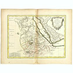
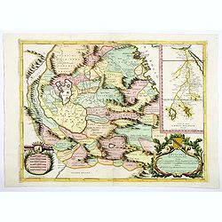
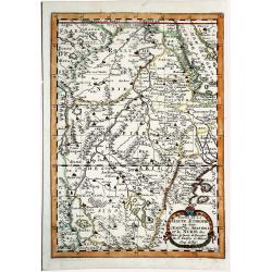
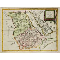
Nubie et Abissinie . . .
Attractive map of East Africa, ornated with a decorative title cartouche. Boundaries outlined in hand color.Prepared by Le Sieur Janvier, Jean Denis [Robert], French geog...
Date: Paris, ca 1783
Selling price: ????
Please login to see price!
Sold in 2019
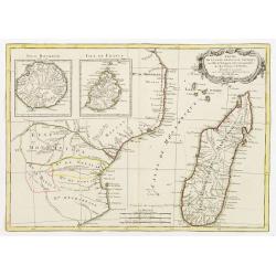
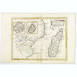
Partie de la Cote Orientale d' Afrique avec l' Isle de Madagascar et les Cartes particulières des Isles de France et de Bourbon..
A map of the south eastern coast of Africa and the island of Madagascar, comprehending 2 insets of the island of Bourbon (today Reunion) and Mauritius.From the Atlas mode...
Date: Paris ca 1783
Selling price: ????
Please login to see price!
Sold
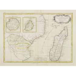
Partie de la Cote Orientale D'Afrique avec l'Isle de Madagascar.. Isles de France et de Bourbon..
Attractive map of part of South Africa, including Madagascar and 2 insets with the Reunion and Mauritius Islands.Ornated with a decorative title cartouche. Boundaries out...
Date: Paris, ca 1783
Selling price: ????
Please login to see price!
Sold
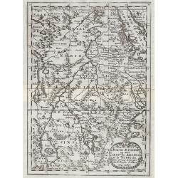
Nubie et Abissinie..
Attractive map showing today Ethiopia and Eritrea. Ornated with a decorative title cartouche. Boundaries outlined in hand color.From theAtlas moderne ou collection de car...
Date: Paris, ca 1783
Selling price: ????
Please login to see price!
Sold
Parte della Costa a Orientale dell'Africa con I'Isola di Madagascar e le Carte particolari dell'Isole di Francia e di Borbon.
An uncommon map of Madagascar with inset maps of the islands of Bourbon and Francia. Mauritius. Embellished with a nice 'scroll' title-cartouche.
Date: Venice, 1784
Selling price: ????
Please login to see price!
Sold in 2018
La Nubia et Abissinia.
An antique map of East Africa: La Nubia et Abissinia by Antonio Zatta, (fl. 1757-1797). Zatta was a Venetian publisher. Published in his atlas of 4 volumes 'Atlante novis...
Date: Venice, 1784
Selling price: ????
Please login to see price!
Sold in 2019
Nubie et Abissinie.
Willem Albert Bachiene (1712-1783), Dutch geographer in Maastricht. Most important work ' Heilige Geographie', a work on the Holy Land. Mathijs Schalenkamp published in 1...
Date: Amsterdam, 1785
Selling price: ????
Please login to see price!
Sold
![[Lot of 7 maps of the lands bordering the Red Sea]](/uploads/cache/20680-250x250.jpg)
[Lot of 7 maps of the lands bordering the Red Sea]
Jan Elwe’s re-issue of Guillaume de l’Isle’s 1707 map of the lands bordering the Red Sea, showing Arabia distinctively.Jan Berend Elwe. Amsterdam-based publisher. P...
Date: Paris, 1792
Selling price: ????
Please login to see price!
Sold in 2022
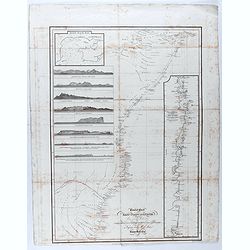
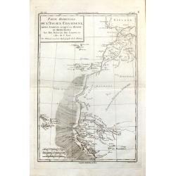
General chart of the East Coast of Africa from various Authorities and corrected by many
Detailed map of the east coast of Africa, supplemented by profiles and a detailed view of the coast from Mozambique to Cape Delgado. Drawn by John Outhett and engraved by...
Date: London, F.C. & J. Rivington, 1814
Selling price: ????
Please login to see price!
Sold in 2020
Nubia and Abyssinia
A pleasant map of Nubia and Abyssinia (Ethiopia) that covers from Darfur east to the Sea of Bab el Mandeb (Gulf of Aden) and from the Desert of Chebba south to Donga. Inc...
Date: London, 1835
Selling price: ????
Please login to see price!
Sold in 2016
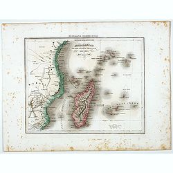
Madagascar e le Isole E le Coste Circonvicine Dell' Africa nel Mar Delle Indie.
Uncommon map of Madagascar, Seychelles, La Réunion and Mauritius and East Coast of Africa around Mozambique, prepared by Francesco Costantino Marmocchi. Above the map &q...
Date: Genova, Paolo Rivara fu Giacomo, 1858
Selling price: ????
Please login to see price!
Sold in 2022
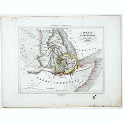
La Nubia E l'Abissinia . . .
Uncommon map of East coast of Africa with Sudan, Nubia and lower Nile, prepared by Francesco Costantino Marmocchi. Above the map "Geografia Commerciale". From &...
Date: Genova, Paolo Rivara fu Giacomo, 1858
Selling price: ????
Please login to see price!
Sold in 2021
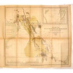
Route Map of the R.G.S. East African Expedition.
Fine map of East Africa published for the Proceedings of the Royal Geographical Society (R.G.S.). Mapmaker was E. Weller.The map area is from Mombasa to Mount Kenia &...
Date: London, 1884
Selling price: ????
Please login to see price!
Sold in 2014
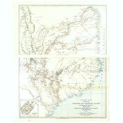
Eastern Africa beteween the Rovuma and Zambesi rivers illustrating the surveys of Mr. J.T. Last.. . .
Map in two sheets of the eastern part of Africa. The Royal Geographical Society (with the Institute of British Geographers) is the Learned Society representing Geography ...
Date: London, J.T Last, 1890
Selling price: ????
Please login to see price!
Sold in 2021
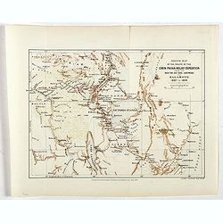
Sketch map of the route of the Emin Pasha relief expedition from the mounth of the Aruwimi to Bagamyo 1887 to 1889.
One of the first maps of the Emin Pasha relief expedition route from the mouth of the Aruwimi to Bagamoyo 1887 to 1889, his track shown in a red line.Fine colored lithogr...
Date: London, Edward Stanford, 1890
Selling price: ????
Please login to see price!
Sold in 2017
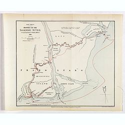
East Africa. Mounts of the Zambesi River surveyed by Daniel J.Rankin, M.R.A.S. 1889.
One of the first maps of the mouths of the Zambesi River surveyed by Daniel J.Rankin in 1889, his track shown in a red line.Fine colored lithograph map lithographed by Tu...
Date: London, Edward Stanford, 1890
Selling price: ????
Please login to see price!
Sold in 2019
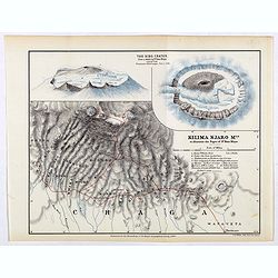
Kilima Njaro Mtn. to illustrate the paper of Dr. Hans Meyer.
One of the first maps of Mount Kilima Njaro with insets of the Bibo Crater, the route of dr. Hans Meyer shown in a red line.Fine colored lithograph map lithographed by F....
Date: London, Edward Stanford, 1890
Selling price: ????
Please login to see price!
Sold in 2017
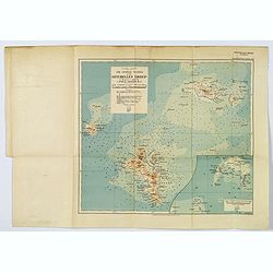
The Central Islands of the Seychelles Group. . .
A nice 'modern' map of the Seychelles, published 'to illustrate a paper by J. Stanley Gardiner, M.A.'. With a small reference table beneath the title and scales, inset of...
Date: London, 1907
Selling price: ????
Please login to see price!
Sold in 2019
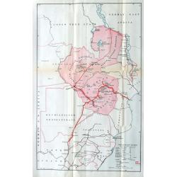
*untitled*
Very unusual and rare Railway map of todays Zimbabwe, parts of Mozambique, and parts of South Africa, parts of Congo and Tansania. Extends from Lake Tanganyika south unt...
Date: London, c1910
Selling price: ????
Please login to see price!
Sold in 2022
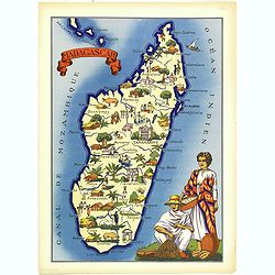
Madagascar.
Very decorative, informative map of Madagascar. The map is filled with buildings, animals, figures and two locals in their typical dress.In lower left corner "Imprim...
Date: France, 1943
Selling price: ????
Please login to see price!
Sold in 2018
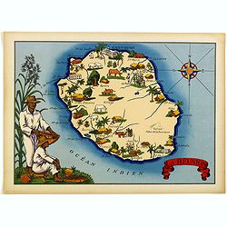
La Réunion.
Very decorative, informative map of the island of Reunion. The map is filled with buildings, animals, figures and two locals. With a large compass rose in upper right cor...
Date: France, 1943
Selling price: ????
Please login to see price!
Sold in 2018
