Browse Listings in Africa > Central Africa > Central Africa
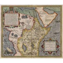
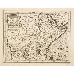
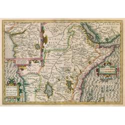
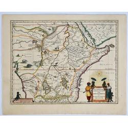
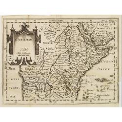
Presbiteri Iohannis, Sive, Abissinorum Imperii Descriptio.
Despite the title this map extends far beyond Prester John's supposed kingdom. It covers Africa from the fabled mountains of the moon in the centre of the continent north...
Date: Antwerp, 1575
Selling price: ????
Please login to see price!
Sold in 2010
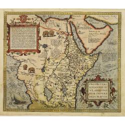
Presbiteri Iohannis.
Stunning map of the kingdom of the mythical Christian king who according to legend provided a stronghold against Barbarians and was an ally to the crusaders. Ortelius des...
Date: Antwerp 1579
Selling price: ????
Please login to see price!
Sold
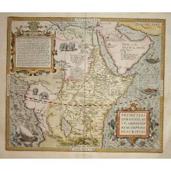
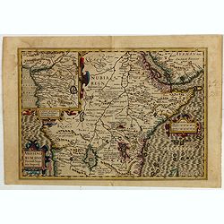
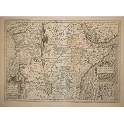
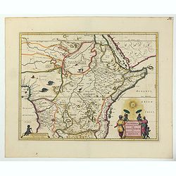
Presbiteri Iohannis, Sive, Abissin Orum Imperii Descriptio
Despite the title this map extends far beyond Prester John's supposed kingdom. It covers Africa from the fabled mountains of the moon in the center of the continent north...
Date: Antwerp 1590
Selling price: ????
Please login to see price!
Sold
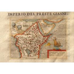
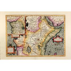
Imperio Del Preste Gianni - Presbeteri Ioannis Sive Abissinorum Imperii Descriptio.
Charming map of the legendary land of the Christian king, Prester John, inset in Italian text (recto and verso). From "La seconda parte delle relazioni universali&qu...
Date: Breschia c. 1599
Selling price: ????
Please login to see price!
Sold in 2011
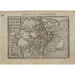
Abiffinorum Imperium
After A. Ortelius.
Date: Antwerp, c. 1600
Selling price: ????
Please login to see price!
Sold
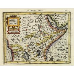
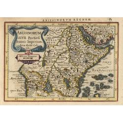
Abissinorum Regnu.
Early map of Central Africa with decorative strap work title cartouche. From the first French-text edition of Jodocus Hondius' Atlas Minor.Shortly after the publication o...
Date: Amsterdam, 1608
Selling price: ????
Please login to see price!
Sold in 2019
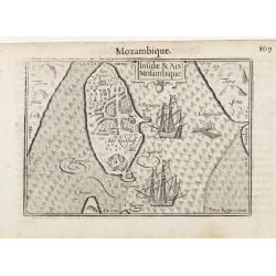
Insulae et Ars Mosambique / Mozambique.
Very fine early miniature map of Mozambique. Title cartouche on the upper right side. Two ships and three men fishing on a small boat are depicted.First published in 1598...
Date: Amsterdam/ Frankfurt 1609
Selling price: ????
Please login to see price!
Sold in 2015
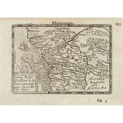
Congo Regni Christiani in Africa / Manicongo.
Early miniature map of central part of Africa, from Guinea to Angola. Title cartouche in the lower left corner.First published in 1598 in his Caert-Thresoor, the plates w...
Date: Amsterdam / Frankfurt 1609
Selling price: ????
Please login to see price!
Sold in 2009
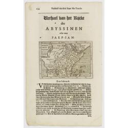
Abissinorum regnu.
Early map of Central Africa published in Latin edition of the Mercator/Hondius Atlas Minor .It covers central Africa around the fabled mountains of the moon in the center...
Date: Amsterdam 1610
Selling price: ????
Please login to see price!
Sold
Abyssinen / Acomath .I. Turcarum Imperator .XIIX. Ex Stirp. Ottomannica. / Abissinorum Imperium.
The engraving depicts a half length oval portrait of "Acomath I". Map of central Africa on verso.Nicolaes de Clerck (de Klerc) was active as engraver and publis...
Date: Amsterdam, Cloppenburch, 1621
Selling price: ????
Please login to see price!
Sold in 2013
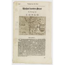
Congo Regnum Christian. In Africa.
Small map illustrating the western seashores of Central Africa, surrounded by text in Dutch.Nicolaes de Clerck (de Klerc) was active as engraver and publisher in Delft fr...
Date: Amsterdam, Cloppenburch, 1621
Selling price: ????
Please login to see price!
Sold in 2009
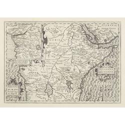
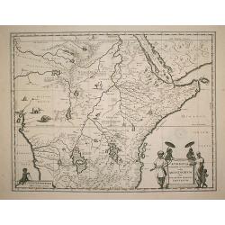
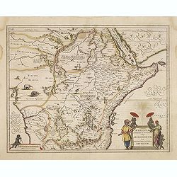
Abissinorum sive Pretiosi Joannis Imperiu.
Despite the title this map extends far beyond Prester John's supposed kingdom. It covers Africa from the fabled mountains of the moon in the center of the continent north...
Date: Amsterdam, 1628
Selling price: ????
Please login to see price!
Sold in 2016
Abissinorum sive Pretiosi Ioannis Imperiu
Hondius' Prester John Map. French text on verso.
Date: Amsterdam, 1628
Selling price: ????
Please login to see price!
Sold in 2010
Abissinorum sive Pretiosi Joannis Imperiu.
Despite the title this map extends far beyond Prester John's supposed kingdom. It covers Africa from the fabled mountains of the moon in the center of the continent north...
Date: Amsterdam, 1630
Selling price: ????
Please login to see price!
Sold in 2010
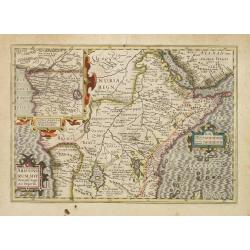
Abissinorum sive Pretiosi Joannis Imperiu.
Despite the title this map extends far beyond Prester John's supposed kingdom. It covers Africa from the fabled mountains of the moon in the center of the continent north...
Date: Amsterdam, 1630
Selling price: ????
Please login to see price!
Sold
Abissinorum sive Pretiosi Joannis Imperiu.
Despite the title this map extends far beyond Prester John's supposed kingdom. It covers Africa from the fabled mountains of the moon in the center of the continent north...
Date: Amsterdam 1630
Selling price: ????
Please login to see price!
Sold
Abissinorum..
Nice map engraved by Petrus Kaerius. It depicts the kingdom of the fabled Christian king Prester John, with his fortified kingdom shown on a mountain. The Nile River eman...
Date: Amsterdam 1634
Selling price: ????
Please login to see price!
Sold
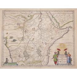
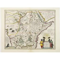
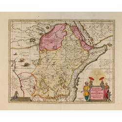
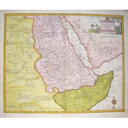
Aethiopia Superior vel Interior vulgo Abissinorum.
An attractive map of Eastern African and the fictitious kingdom of Prester John, issued by Willem Janszoon Blaeu in 1635.The map shows a major section of central and eas...
Date: Amsterdam 1635
Selling price: ????
Please login to see price!
Sold in 2016
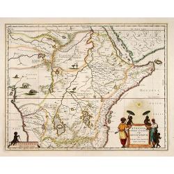
Aethiopia Superior vel Interior; vulgo Abissinorum.
An attractive map of the Eastern African and the fictitious kingdom of Prester John. The map shows a major section of central and eastern Africa including Mozambique nort...
Date: Amsterdam 1638
Selling price: ????
Please login to see price!
Sold
Aethiopia Superior vel Interior vulgo Abissinorum.
An attractive map of the Eastern African and the fictitious kingdom of Prester John. The map shows a major section of central and eastern Africa including Mozambique nort...
Date: Amsterdam, 1638
Selling price: ????
Please login to see price!
Sold in 2014
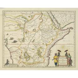
Aethiopia Superior vel Interior; vulgo Abissinorum. 

An attractive map of the Eastern African and the fictitious kingdom of 'Prester John'. The map shows a major section of central and eastern Africa including Mozambique no...
Date: Amsterdam, 1638
Selling price: ????
Please login to see price!
Sold in 2019
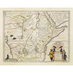
Abissinorum sive Pretiosi Ioannis Imperiu
Hand colored map of Central Africa by G. Mercator. With two beautiful colored cartouche and one inset map of the Congo. Showing the Kingdom of Prester John in central Afr...
Date: Amsterdam, 1640
Selling price: ????
Please login to see price!
Sold in 2013
Aethiopia Superior vel Interior vulgo Abissinorum.
An attractive map of the Eastern African and the fictitious kingdom of Prester John. The map shows a major section of central and eastern Africa including Mozambique nort...
Date: Amsterdam, ca 1640
Selling price: ????
Please login to see price!
Sold in 2022
Aethiopia Superior vel Interior vulgo Abissinorum.
An attractive map of the Eastern African and the fictitious kingdom of Prester John. The map shows a major section of central and eastern Africa including Mozambique nort...
Date: Amsterdam, 1640
Selling price: ????
Please login to see price!
Sold in 2009
Aethiopia Superior vel Interior vulgo Abissinorum.
An attractive map of the Eastern African and the fictitious kingdom of Prester John. The map shows a major section of central and eastern Africa including Mozambique nort...
Date: Amsterdam 1640
Selling price: ????
Please login to see price!
Sold
Aethiopia superior vel interior.
An attractive map of the Eastern African and the fictitious kingdom of Prester John. The map shows a major section of central and eastern Africa including Mozambique nort...
Date: Amsterdam, 1639-1649
Selling price: ????
Please login to see price!
Sold in 2014
Aethiopia Superior vel Interior vulgo Abissinorum.
An attractive map of the Eastern African and the fictitious kingdom of Prester John. The map shows a major section of central and eastern Africa including Mozambique nort...
Date: Amsterdam, 1658
Selling price: ????
Please login to see price!
Sold in 2010
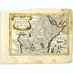
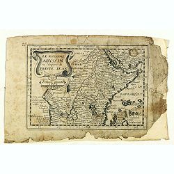
Le royaume d'Abyssinie ou l'Empire du Prete Iean. (14).
Scarce map of Abyssinia and Ethiopia published by Antoine de Fer in 1661 or 1662 in "Cartes de géographie revues et augmentées". With number 14 in lower right...
Date: Paris, Antoine de Fer, 1657 but 1661 or 1662
Selling price: ????
Please login to see price!
Sold in 2020
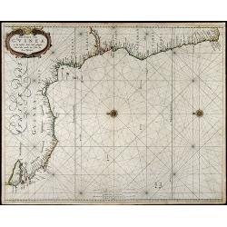
Pas-Caart van Guinea en de Custen daer aen gelegen Van Cabo verde tot Cabo de Bona Esperanca
Beautiful seachart of the southwest coast of Africa by P. Goos from the famous sea atlas "De Zee-Atlas ofte Water-Weereld". Showing the coatlines of Guinea, Sie...
Date: Amsterdam, 1666
Selling price: ????
Please login to see price!
Sold in 2008
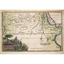
Partie de la Haute Aethiopie. . .
Map of Ethiopia prepared by N.Sanson and published by Pierre Mariette.Published in an early edition of the small Sanson atlas L'Europe Dediée a Monseigneur . . . Le Tell...
Date: Paris, P. Mariette, 1667
Selling price: ????
Please login to see price!
Sold in 2008
Le Royaume Abyssin ou l'Empire du Presteiean.
Rare map of Central Africa with Ethiopia, published by Jollain in 1667. Published in "Trésor Des Cartes Geographiques Des Principaux Estats de Lunivers".This a...
Date: Paris, 1667
Selling price: ????
Please login to see price!
Sold in 2021
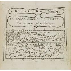
Le Biledulgerid ou Numidie et le Zaara autrement le Desert.
Uncommon miniature map of Sahara Dessert and Algeria, from Pierre Duval's La Geographie Universeille dated 1676. Following his Cartes de geographie in 1657, Pierre Duval ...
Date: Paris, 1676
Selling price: ????
Please login to see price!
Sold in 2009
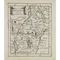
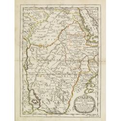
Abissinie ou Haute Ethiopie.
Uncommon miniature map of Ethiopia from Pierre Duval's La Geographie Universeille dated 1676. Following his Cartes de geographie in 1657, Pierre Duval published this smal...
Date: Paris, 1676
Selling price: ????
Please login to see price!
Sold in 2008
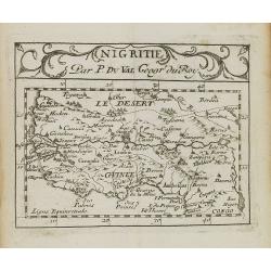
Nigritie.
Uncommon miniature map of Guinea and Africa's Gold Coast, from Pierre Duval's La Geographie Universeille dated 1676. Following his Cartes de geographie in 1657, Pierre Du...
Date: Paris, 1676
Selling price: ????
Please login to see price!
Sold in 2009
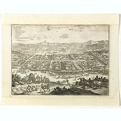
The city of Loango from Dapper.
Copper engraved page view of Loango from Olfert Dapper. The view shows the city of Loango capital of the kingdom of the same name which lay in what is now the Republic of...
Date: Amsterdam, 1686
Selling price: ????
Please login to see price!
Sold in 2019
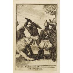
Negres. Habitans de Nubie de Nigritie et de Guinée.
Decorative engraving representing people of Central Africa.
Date: Amsterdam, 1700
Selling price: ????
Please login to see price!
Sold in 2008
L'Abissinie.
Uncommon and delightful map of Equatorial Africa, extending from the Atlantic shores as far as the Horn of Africa.It is focused on the White Nile stream which bears the n...
Date: Amsterdam 1700
Selling price: ????
Please login to see price!
Sold
Aethiopia Superior vel Interior vulgo Abissinorum.
An attractive map of the Eastern African and the fictitious kingdom of Prester John. The map shows a major section of central and eastern Africa including Mozambique nort...
Date: Amsterdam, 1708
Selling price: ????
Please login to see price!
Sold in 2010
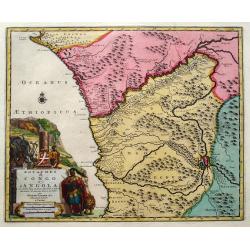
Royaumes de Congo et d'Angola...
Scarce regional map centered on the Zaire river. Extends from about Port Gentil to Lobito. With several place names mainly along the Congo River. With a very large title ...
Date: Leiden, 1720
Selling price: ????
Please login to see price!
Sold in 2018
Africa Interior.
Christoph Cellarius (1638-1707). Geographia Antiqua, 1686
Date: Leipzig, Gledisch, 1732
Selling price: ????
Please login to see price!
Sold in 2019
A New and Accurate Map of Nubia....
Folding page map showing area from lower Egypt, through Sudan and Ethiopia and down to Somalia. The map also includes the Red Sea and what is now Yemen and South Arabia. ...
Date: London 1747
Selling price: ????
Please login to see price!
Sold
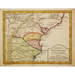
Empire du Monomotapa et Etats Voisins.
Jaques Nicolas Bellin (1702-720) was the most important French hydrographer of the 18th century. Sea-atlas 'Hydrographique Français' , 1756-65, atlas to accompany Prévo...
Date: Paris, c. 1750
Selling price: ????
Please login to see price!
Sold in 2008
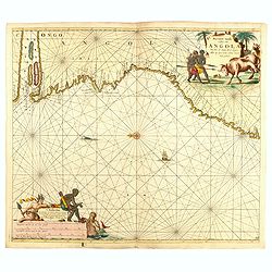
Pas caert vande cuften van Angola van Rio de Zaire...
This decorative sea chart of Angola features many place names along the coast. In the upper right corner, we see a figurative title cartouche, and in the lower left corn...
Date: Amsterdam, 1751
Selling price: ????
Please login to see price!
Sold in 2016
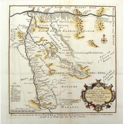
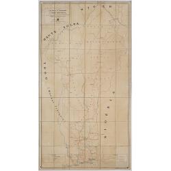
Carte du Cours des Rivieres de Falemeet Sanaga Dans les Pays de Bamucet Tamba Awra.
Interesting original map of western Mali with the Senegal and Niger Rivers showing the important Bambuk region. This is the area that has Cameroon gold mining. Engraved b...
Date: Paris, 1757
Selling price: ????
Please login to see price!
Sold in 2018
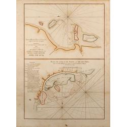
Plan de l'Isle de Patte et de son Port / Plan des Isles Querimbo, Oybo et Matemo.
Two finely colored sea charts of the coast of Africa on one sheet. Showing several Islands at the coast of Kenya and Mozambique. From the second revised and enlarged edit...
Date: Paris, 1775
Selling price: ????
Please login to see price!
Sold in 2015
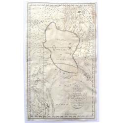
To My Worthy and Learned Friend the Honourable Daines Barrington This Plan of two Attempts to Arrive at the Source of the Nile is dedicated by his most Obliged and faithful Humble Servant James Bruce.
This is a significant, engraved, 1790 map of Ethiopia (Abyssinia) and the source of the Blue Nile by the Scottish adventurer James Bruce. Centered on Lake Tana (Tzana), t...
Date: London, 1790
Selling price: ????
Please login to see price!
Sold in 2017
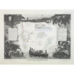
Colonies Françaises (en Afrique). N°91.
Handsome map divided into two sections shows a section of the coast of French West Africa titled 'Senegambie' (Senegal & Gambia) with a drawing of the Senegal River a...
Date: Paris, A. Combette, 1852
Selling price: ????
Please login to see price!
Sold in 2009
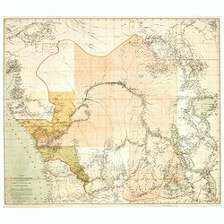
Karte des Kongobeckens und der angrenzenden Gebiete, zugleich Darstellung der Ausdehnung des Kongostaates. Von Henry M. Stanley.
Detailed map in a scale of 1:2.900.000 of the Congo Basin and the bordering regions, also showing the expansion of the State of the Congo. By Henry M. Stanley. Sir Henry ...
Date: Leipzig, 1877
Selling price: ????
Please login to see price!
Sold in 2020
Sketch Map of the Route of the Emin Pasha Relief Expedition
A complete extract from the Proceedings of the Royal Geographical Society of June 1890, p313 ? 331, with the folding map as called for on p.372, now bound in blue covers ...
Date: London, 1890
Selling price: ????
Please login to see price!
Sold
![[Equatorial Africa - map with Ottoman script]](/uploads/cache/44739-250x250.jpg)
[Equatorial Africa - map with Ottoman script]
Postcard size map in Ottoman script of Equatorial Africa from Mehmet Eşref’s ‘Küçük Atlas’, a rare portfolio of loose-leaf postcard-sized maps with text in Ott...
Date: Istanbul, Şirket-i Mürettibiye ve Karacoğlu Matbaası 1325 or 1909
Selling price: ????
Please login to see price!
Sold in 2022
Colonie du Dahomey Carte Routiere dressée au service Géographique de l'A.O.F. Dakar.
Dissected and mounted on linen road map of Dahomey colony, on witch the limits of the state, the colony, and the circle are indicated.
Date: Paris, ca. 1928
Selling price: ????
Please login to see price!
Sold in 2017
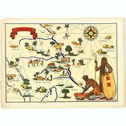
Niger.
Very decorative, informative map of Nigeria. The map is filled with buildings, animals, figures and two locals. With a large compass rose in upper right corner.In lower l...
Date: France, 1943
Selling price: ????
Please login to see price!
Sold in 2016
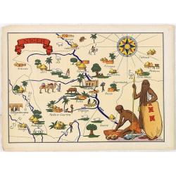
Niger.
Very decorative, informative map of Nigeria. The map is filled with buildings, animals, figures and two locals. With a large compass rose in upper right corner.In lower l...
Date: France, 1943
Selling price: ????
Please login to see price!
Sold in 2018
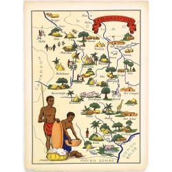
Oubangui-Chari.
Very decorative, informative map of Central Africa. The map is filled with buildings, animals, figures and two locals in their typical dress.In lower left corner "Im...
Date: France, 1943
Selling price: ????
Please login to see price!
Sold in 2018
