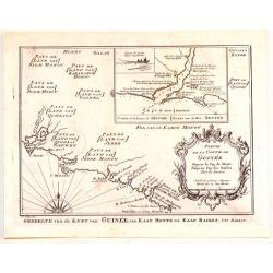
Browse Listings in Africa > Central Africa
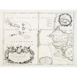
Bocche del Fiume Negro et Isole di Capo Verde..
This is a splendid map of the northwestern coast of Africa and the Cape Verde Islands.The map provides details of the various Portuguese discoveries in the region in the ...
Date: Venice 1690
Selling price: ????
Please login to see price!
Sold in 2008
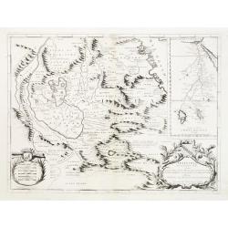
![[Untitled: La Guinea].](/uploads/cache/23454-250x250.jpg)
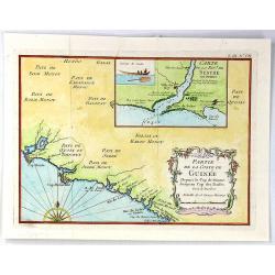
[Untitled: La Guinea].
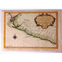
Charming small map of the west coast of Africa centered on the Gulf of Guinea covering the coast from the Ivory coast as far as Gabon.The remarkable Vincenzo Coronelli (1...
Date: Venice 1690
Selling price: ????
Please login to see price!
Sold
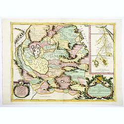
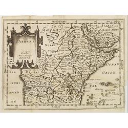
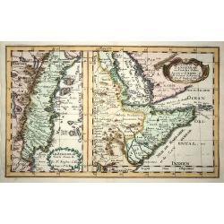
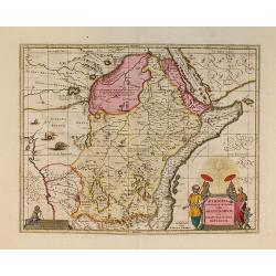
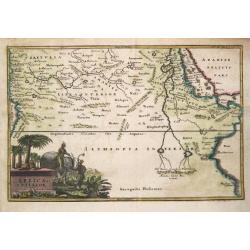
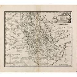
Abissinia, doue sono le Fonti del Nilo..
This very uncommon map concentrates of the source of the Nile in a lake called Tzana, Dembea, which Coronelli claimed to be the first to accurately depict.Extensive notat...
Date: Venice 1690
Selling price: ????
Please login to see price!
Sold
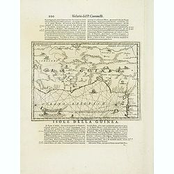
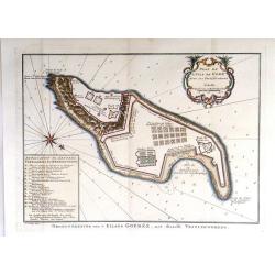
Isola della Guinea. / Isola Gore.
Fine map of Guinea, from Isolario Dell'Atlante Vento.On verso a map of the island Goeree (130x172mm).
Date: Venice, 1690
Selling price: ????
Please login to see price!
Sold in 2018
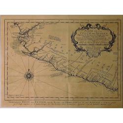
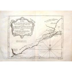
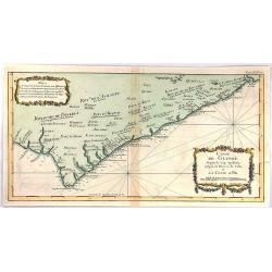
Isola della Guinea.
Fine map of Guinea, from Isolario Dell'Atlante Vento. The sheet dimension is 485x350mm. Information is largely confined to the coast and the Niger River, which flows in p...
Date: Venice, 1690
Selling price: ????
Please login to see price!
Sold in 2018
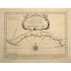
Abissinia, doue sono le Fonti del Nilo.
This very uncommon map concentrates of the source of the Blue Nile in a lake called Tzana, Dembea, which Coronelli claimed to be the first to accurately depict.Extensive ...
Date: Venice, 1690
Selling price: ????
Please login to see price!
Sold in 2018
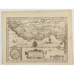
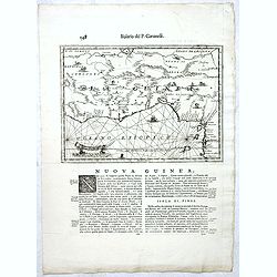
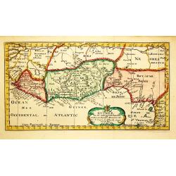
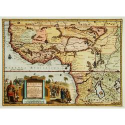
Guineae Nova Descriptio.
The map shows the West African coast from Senegal to Cape Lopez on the Gulf of Guinea just below the equator. The island of St. Thomae, which today forms a Portuguese pro...
Date: Amsterdam, W. de Jonge, 1690
Selling price: ????
Please login to see price!
Sold in 2023
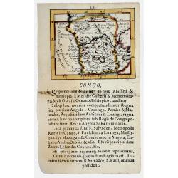
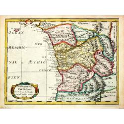
CONGO. 1692
Lovely miniature map showing Congo in the west coast of central Africa.From the "Neu aussgeffertigter kleiner Atlas" one of the rarest and most interesting of a...
Date: Frankfurt, 1692
Selling price: ????
Please login to see price!
Sold in 2020
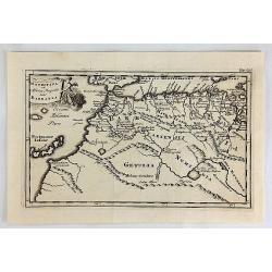
Mauritana et Africa Proria nunc Barbaria.
A pleasantly engraved map of the north-western part of Africa with the Canary Islands.
Date: Leiden, 1697
Selling price: ????
Please login to see price!
Sold in 2019
L'Abissinie.
Uncommon and delightful map of Equatorial Africa, extending from the Atlantic shores as far as the Horn of Africa.It is focused on the White Nile stream which bears the n...
Date: Amsterdam 1700
Selling price: ????
Please login to see price!
Sold
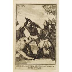
Negres. Habitans de Nubie de Nigritie et de Guinée.
Decorative engraving representing people of Central Africa.
Date: Amsterdam, 1700
Selling price: ????
Please login to see price!
Sold in 2008
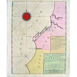
Carte Particuliere des costes de l'Afrique qui comprend une partie de Congo
Beautiful chart from Mortier's edition of Le Neptune François. Covers the region near the Congo River including Loanda, Ponta dos Palmeirinha, and Cabo Ledo. A text cart...
Date: Amsterdam, c1700
Selling price: ????
Please login to see price!
Sold in 2008
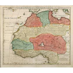
Carte De La Barbarie Le La Nigritie Et De La Guinee
Detailed hand colored copper engraving showing North West Africa from Mediterranean Sea to Gulf of Guinea including Canary Island.
Date: 1700
Selling price: ????
Please login to see price!
Sold in 2009
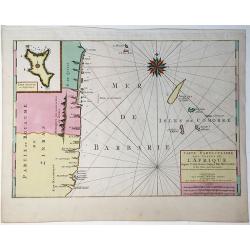
Le Zanguebar Tiree de Sanut &c. / Partie du Zanguebar ou Sont les Costes d'Ajan et d'Abix &c.
This attractive map, in two parts, covers the east coast of Africa from Mozambique to the Red Sea showing the prosperous trading ports. Each map has a decorative title ca...
Date: Amsterdam, 1700
Selling price: ????
Please login to see price!
Sold in 2008
Nieuwe en Naauwkeurige Paskaart van de Guineese, Goud, Tand en Slave Kust ? - Nouvelle carte des Cotes de Guinée, d\'Or, de Dent et des Esclaves. . .
Uncommon sea chart of Africa\'s Gold coast (Cap Verde) to Cape of Good Hope.
Date: Amsterdam, 1700
Selling price: ????
Please login to see price!
Sold in 2008
Carte Particuliere des costes de l'Afrique qui comprend une partie della Guinée et Partie de Mina...
Beautiful chart from Mortier's rare edition of 'Le Neptune François.' Covers the region from today's Sierra Leone until the Cape Coast area in Ghana. With numerous towns...
Date: Amsterdam, c1700
Selling price: ????
Please login to see price!
Sold in 2009
Partie de la Haute Aethiopie ...
Map of the East coast of Africa. From Description de tout l'Univers, published by François Halma.
Date: Amsterdam, 1700
Selling price: ????
Please login to see price!
Sold in 2011
Afrique ou Libie Ulterieure ou sont le Saara ou Desert, ...
Map of the Ivory Coast. From Description de tout l'Univers, published by François Halma.
Date: Amsterdam, 1700
Selling price: ????
Please login to see price!
Sold in 2011
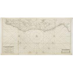
Pas caerte vande Custen van Loango, Angoy als mede en gedeelte van Angola, van C. de Lopa Goncalves, tot aen R. de Zaire.
Sea-chart of the coast of Loango.Latitude scale, compass rose and system of rhumb lines, soundings, anchorage's, etc.
Date: Amsterdam, ca. 1700
Selling price: ????
Please login to see price!
Sold in 2014
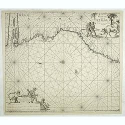
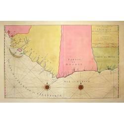
Pas caert van de Custen van Angola Van Rio de Zaire tot C. Negro. alles op zyn ware coers verheyt geleyt.
Sea-chart of the coast of Angola.Latitude scale, compass rose and system of rhumb lines, soundings, anchorage's, etc. Number "8" in lower right corner.
Date: Amsterdam, ca. 1700
Selling price: ????
Please login to see price!
Sold in 2014
Mauritana et Africa Propria nunc Barbaria.
A nice engraved map of the north-western part of Africa with the Canary Islands by Phillip Clüver in about 1700. With one cartouche featuring an angel.Philipp Clüver (...
Date: Paris, ca 1700
Selling price: ????
Please login to see price!
Sold in 2018
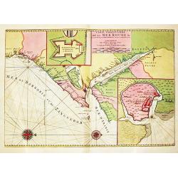
Carte Particuliere de la Mer Rouge &c.
An attractive sea chart of the Red Sea, Africa's Indian ocean coast from the Red Sea to Mozambique and the southwest coast of Arabia. With insets of Mombassa and fort and...
Date: Amsterdam, 1700
Selling price: ????
Please login to see price!
Sold in 2020
Partie de la HAUTE AETHIOPIE ou sont L'EMPIRE des ABISSINS et la NUBIE &c.
An excellent map of the Nile with its mythical sources. Shows the Nile River from Zaire Lake and Zaflant Lake, until Assuan / Aswan). Richly detailed with place names, hi...
Date: Paris, ca 1700
Selling price: ????
Please login to see price!
Sold in 2019
LA GUINEE et Pays circonvoisins.
Attractive copper engraved map of the Guinea coast including Guinea, Benin and Congo. Nicely detailed and decorated with a title cartouche that credits Gerard Mercator an...
Date: Amsterdam 1700
Selling price: ????
Please login to see price!
Sold in 2019
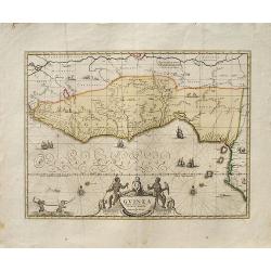
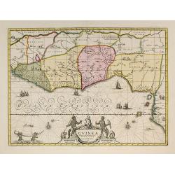
Guinea.
A decorative map of West Africa. The map includes numerous animals in the interior, sailing ships and an elegant cartouche. Published in Amsterdam by P. Schenk and G. Val...
Date: Amsterdam, ca. 1700
Selling price: ????
Please login to see price!
Sold in 2019
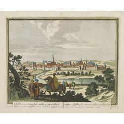
Amara, een voorname stadt midden in opper Ethiopie, Abyssine genaamt, ..
From Schenk's Hecatompolis sive Totius Terrarum Oppida Nobiliora Centrum.. , a collection of 100 views, dedicated to the 14-year old Prussian crown prince, the later king...
Date: Amsterdam, 1702
Selling price: ????
Please login to see price!
Sold in 2016
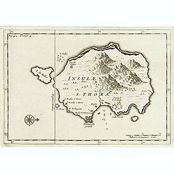
Insulae S. Thomae.
Uncommon map of the Island of St. Thomas located in the Atlantic Ocean near West Africa. From a travel book deScribing the early Dutch voyages by René Augustin Constanti...
Date: Amsterdam, E. Roger, 1703
Selling price: ????
Please login to see price!
Sold in 2012
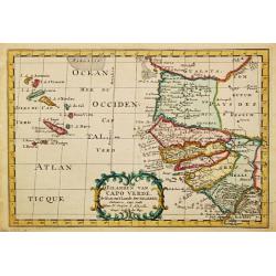
D' Eilanden van Capo Verde, de kust en 't landt der Negeren.
Nicolas Sanson (1600-67), ' father of the French cartography' and founder of the Sanson firm. Atlas ' Cartes générales de toutes les parties du Monde', 1658-70 and a po...
Date: Amsterdam, F. Halma, 1705
Selling price: ????
Please login to see price!
Sold in 2009
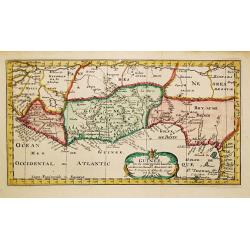
Guinee.
Nicolas Sanson (1600-67), ' father of the French cartography' and founder of the Sanson firm. Atlas ' Cartes générales de toutes les parties du Monde', 1658-70 and a po...
Date: Amsterdam, F.Halma, 1705
Selling price: ????
Please login to see price!
Sold
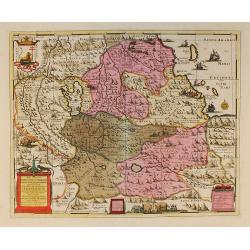
T Koninkrijk van Congo.
Nicolas Sanson (1600-67), ' father of the French cartography' and founder of the Sanson firm. Atlas ' Cartes générales de toutes les parties du Monde', 1658-70 and a po...
Date: Amsterdam, 1705
Selling price: ????
Please login to see price!
Sold in 2017
Guinee.
Nicolas Sanson (1600-67), ' father of the French cartography' and founder of the Sanson firm. Atlas ' Cartes générales de toutes les parties du Monde', 1658-70 and a po...
Date: Amsterdam, F.Halma, 1705
Selling price: ????
Please login to see price!
Sold
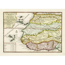
Partie occidentale d'Afrique ou se trouve les Isles Canaries. . .
The map includes Western Africa and the Canary Islands and Cape Verde. Engraved by C.Inselin. From his "Atlas Curieux", published 1700-1705.
Date: Paris, 1705
Selling price: ????
Please login to see price!
Sold in 2011
Aethiopie of Abissine. In 't gemeen 't Land van Preste Jan Genoemd.
Pieter van der Aa was a prolific publisher. He published a.o. ' Naauwkeurge versameling der gedenkwaardigste zee- en land-reysen', a series of accounts of voyages (1706-0...
Date: Leiden, 1707
Selling price: ????
Please login to see price!
Sold
Aethiopia Superior vel Interior vulgo Abissinorum.
An attractive map of the Eastern African and the fictitious kingdom of Prester John. The map shows a major section of central and eastern Africa including Mozambique nort...
Date: Amsterdam, 1708
Selling price: ????
Please login to see price!
Sold in 2010
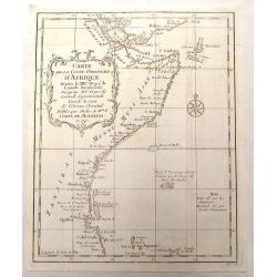
Carte Particuliere Des Costes De L'Afrique Depuis C.Del Gado Jusques Rio Mocambo.
A fine sea chart of the coasts of Mozambique and Tanzania and the Comoro Islands. Full tile: 'Carte Particuliere Des Costes De L'Afrique Depuis C.Del Gado Jusques Rio Moc...
Date: Amsterdam, 1693-1708
Selling price: ????
Please login to see price!
Sold in 2020
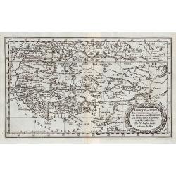
A Description of the Islands of Joanna (Anjouan).
A Description of the Islands of Joanna by Samuel Thornton. Small woodblock chart by Samuel Thornton of The Island of Joanna published in 1711 by John How and Samuel Thorn...
Date: London, 1711
Selling price: ????
Please login to see price!
Sold in 2014
Africae fons illa, quae Mari Atlantico . . .
A uncommon map of West Africa with a large dedicational cartouche lower left corner.From "De situ orbis libri tres, ad omnium Angliae & Hiberniae codicum mss. fi...
Date: London, 1711
Selling price: ????
Please login to see price!
Sold in 2020
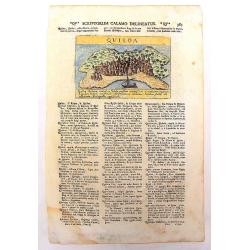
Quiloa
An uncommon, important map of Kilwa , an island off the coast of East Africa, in present day Tanzania. It is from Lazor A Varea's "Universus Terrarum Orbis". A ...
Date: Padua, 1713
Selling price: ????
Please login to see price!
Sold in 2013
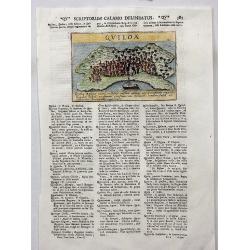
Quiloa.
A charming map of the island nation of Quiloa (Kilwa) off the coast of East Africa, in present day Tanzania near Zanzibar. An attractive small city view (after Valegio) ...
Date: Padua, 1713
Selling price: ????
Please login to see price!
Sold in 2017
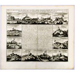
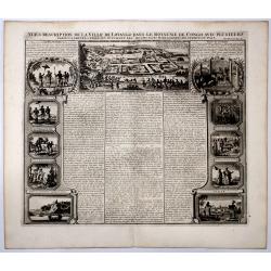
Vue et description des Forts Que Les Hollandois, Anglois, et Danois ont sur la cote de Guinee.
Decorative, copperplate sheet with 12 vies of African Cities, from Chatelain's monumental 7 volume Atlas Historique.Includes a series of views showing Map shows on 12 vie...
Date: Paris 1717
Selling price: ????
Please login to see price!
Sold in 2019
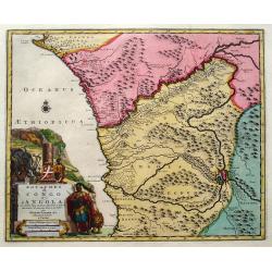
Royaumes de Congo et d'Angola.
Pieter van der Aa was a prolific publisher. He published a.o. ' Naauwkeurge versameling der gedenkwaardigste zee- en land-reysen', a series of accounts of voyages (1706-0...
Date: Leiden, 1719
Selling price: ????
Please login to see price!
Sold
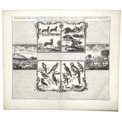
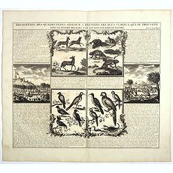
DESCRIPTION DES QUADRUPEDES, OISEAUX & REPTILES LES PLUS CURIEUX QUI SE TROUVENT DANS LA GUINEE . . .
A decorative copperplate engraving showing quadrupeds, reptiles and the birds of Guinea, including a scene with elephants, from Henri Chatelain's monumental 7 volume &quo...
Date: Amsterdam, 1719
Selling price: ????
Please login to see price!
Sold in 2019
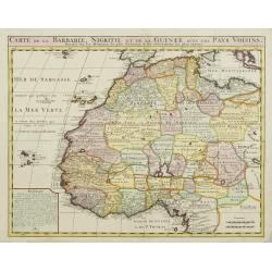
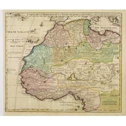
Carte de la Barbarie, Nigritie, et de la Guinée?
Map of North and West Africa, including the Canary Islands, the Cape Verde Islands and the Azores. According to the title "drawn up from early 18th century reports a...
Date: Amsterdam, ca. 1720
Selling price: ????
Please login to see price!
Sold
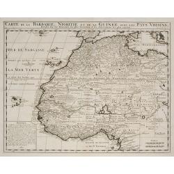
Carte de la Barbarie, Nigritie, et de la Guinée ?
Map of North and West Africa, including the Canary Islands, the Cape Verde Islands and the Azores. According to the title "drawn up from early 18th century reports a...
Date: Amsterdam, ca. 1720
Selling price: ????
Please login to see price!
Sold in 2009
Guinea.
An attractive map, covering the coast from Sierra Leone to Gabon, filed with intersecting rhumb lines and decorated with monkeys, lions, elephants, sea monsters and two c...
Date: Amsterdam, 1720
Selling price: ????
Please login to see price!
Sold in 2009
Jobi Ludolfi Habessinia seu Abassia Presbyteri Johannis ?
Jobi Ludolfus (1624-1704) was a German scholar and historian, specialising in Abyssinia (Ethiopia). His map is one of the earliest, relatively accurate maps of the region...
Date: Amsterdam, 1720
Selling price: ????
Please login to see price!
Sold in 2010
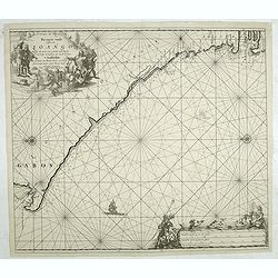
Pas caarte van de Bocht van Gabon Tusschen C. Formose en C. de Lopo Gansalves. . .
This map depicts the west coast of Gabon from Cape Formosa to Cape de Lopo, with the islands of St. Thomas and Principi.
Date: Amsterdam, 1720
Selling price: ????
Please login to see price!
Sold in 2016
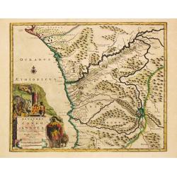
Royaumes de Congo et d'Angola...
Scarce regional map centered on the Zaire river. Extends from about Port Gentil to Lobito. With several place names mainly along the Congo River. With a very large title ...
Date: Leiden, 1720
Selling price: ????
Please login to see price!
Sold in 2018
Description Des Quadrupedes, Oiseaux & Reptiles Les Plus Curieux Qui Se Trouvent Dans La Guinee . . .
Decorative copperplate engraving showing quadrupeds, reptiles and birds of Guinea, including a scene with elephants. From Chatelain's monumental 7 volume "Atlas Hist...
Date: Amsterdam, 1720
Selling price: ????
Please login to see price!
Sold in 2022
Vue & description de la ville de Lovango dans le Royaume de Congo avec plusieurs....
On top a large view of the fabled city of Lovango, text surrounded by ten vignettes of the people and ceremonies of the Kingdom of Congo.Zacharie Chatelain (d.1723) was t...
Date: Amsterdam, 1720
Selling price: ????
Please login to see price!
Sold in 2019
Carte de l'Afrique Françoise ou du Senegal.
De L'Isle's highly detailed map of part of the West Coast of Africa, from Cap Blanc to the Pays des Mallus, centered on the Gambia River and Senegal River. Good detail al...
Date: Paris, 1726
Selling price: ????
Please login to see price!
Sold in 2020
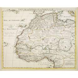
Carte de La Barbarie de La Nigritie et de Guinee.
A detailed engraved map of north west Africa including the Canary and Cape Verde Islands. The title is displayed along the top of the map. A rare re-issue of De l'Isles m...
Date: Amsterdam, 1727
Selling price: ????
Please login to see price!
Sold in 2012
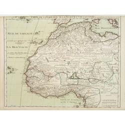
Nigritie, ou le Pays des Negres, en Afrique...
Map of West Africa. With beautiful title cartouche.
Date: Leiden , c.1728
Selling price: ????
Please login to see price!
Sold
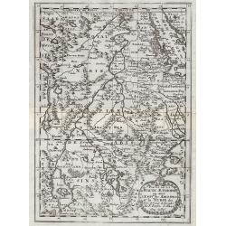
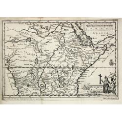
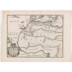
Africa Interior.
Christoph Cellarius (1638-1707). Geographia Antiqua, 1686
Date: Leipzig, Gledisch, 1732
Selling price: ????
Please login to see price!
Sold in 2019
Coste Occidentale D'Afrique Depuis le XIe. Degre De Latitude Meridional
Detailed map featuring the southwest coast of Africa from “Cap de Bonne Esperance” (Cape of Good Hope), “Hottentots” (modern South Africa) in the south to “St. ...
Date: Paris, 1739
Selling price: ????
Please login to see price!
Sold in 2016
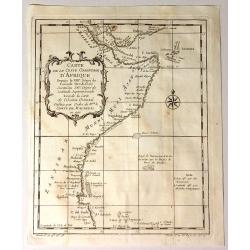
Carte de la Coste Orientale D'Afrique.
Fine detailed map from the Saudi Arabia (Mekka) coast til the Tanzanian coast. From Prevost's "L'HISTOIRE GENERALE DES VOYAGES".
Date: Paris, 1740
Selling price: ????
Please login to see price!
Sold in 2017
Carte de la Coste Orientale D'Afrique Depuis le XIIIe Degree de Latitude Meridionale
Attractive map of the East Coast of Africa from Dahlak Island in the Red Sea to the Comoro Islands. Produced by Jacques Nicolas Bellin (1703-1772). It features a decora...
Date: Paris, 1740
Selling price: ????
Please login to see price!
Sold in 2015
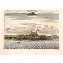
The Prospect of Fort Nassaw at Mouree, Seen from the Sea.
A fine copper engraved print featuring a scene of Fort Nassaw in Guinea. From John Barbot's "A Description of Nort and South Guinea" published in London in 1744...
Date: London, 1744
Selling price: ????
Please login to see price!
Sold in 2015
Carte de la Barbarie de la Nigritie et de la Guinée..
Richly engraved map of North and West Africa, based upon the earlier maps of De L'Isle. Richly annotated throughout and with excellent regional detail. It includes the Ca...
Date: Amsterdam c. 1745
Selling price: ????
Please login to see price!
Sold
Carte de la Barbarie de la Nigritie et de la Guinée..
Richly engraved map of North and West Africa, based upon the earlier maps of De L'Isle. Richly annotated throughout and with excellent regional detail. It includes the Ca...
Date: Amsterdam, c. 1745
Selling price: ????
Please login to see price!
Sold in 2022
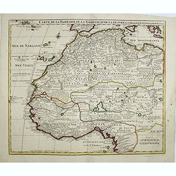
Carte de La Barbarie de La Nigritie et de la Guinée.
Richly engraved map of North and West Africa, based upon the earlier maps of De L'Isle. Richly annotated throughout and with excellent regional detail. It includes the Ca...
Date: Amsterdam, ca. 1745
Selling price: ????
Please login to see price!
Sold in 2014
![[Lot of 10 maps of Guinea.] Tractus Littorales Guinea a promontorio Verde.](/uploads/cache/82292-250x250.jpg)
[Lot of 10 maps of Guinea.] Tractus Littorales Guinea a promontorio Verde.
A fine chart, originally published by Frederick de Wit, corrected and re-issued by the Ottens brothers. A large, finely etched title-cartouche. The Guinea coast played an...
Date: Amsterdam, 1745
Selling price: ????
Please login to see price!
Sold in 2022
Partie de la Coste de Guinee, Depuis la Riviere de Sierra Leona Jusquan Cap das Palmas.
Detailed map of the Guinea coast in West Africa, from the Sierra Leone River to Cape Palmas on the southern coast of what is now Liberia, from the atlas of Prevost d'Exil...
Date: Paris, 1746
Selling price: ????
Please login to see price!
Sold in 2017
Partie de la Coste de Guinee Depuis la Riviere de Sierre Leona Jusquau Cap das Palmas . . .
The coasts of present-day Sierre Leone and Liberia in Western Africa are shown on this map. All along the coasts are depth sounds. The map features an attractive title ca...
Date: Paris, 1746
Selling price: ????
Please login to see price!
Sold in 2019
Suite de la Coste de Guinee Depuis le Cap de Palme Jusqu' au Cap des Trois Pointes...
Old map of the Ivory coast showing the kingdoms of the Côte d'Ivoire and Ghana in West Africa. From Antoine-François Prevost's L`Histoire Generale des Voyages. Feature...
Date: Paris, 1746
Selling price: ????
Please login to see price!
Sold in 2019
A New and Accurate Map of Nubia....
Folding page map showing area from lower Egypt, through Sudan and Ethiopia and down to Somalia. The map also includes the Red Sea and what is now Yemen and South Arabia. ...
Date: London 1747
Selling price: ????
Please login to see price!
Sold
Partie de la Coste de Guinee Depuis le Cap de Monte Jusqu'au Cap des Basses.
Fine little map engraved by Schley featuring the coast of Guinee in Western Africa. The insert is of the Sestos River. Pleasing floral, title cartouche. The map was publi...
Date: Paris, 1747
Selling price: ????
Please login to see price!
Sold in 2015
A New and Accurate Map of Nubia & Abissinia, Together with All the Kingdoms Tributary there...
Showing the area from lower Egypt, through Sudan and Ethiopia and down to Somalia. The map also includes the Red Sea and what is now Yemen and South Arabia. Blank on vers...
Date: London, 1747
Selling price: ????
Please login to see price!
Sold in 2013
Suite de la Coste de Guinnee Deouis la Riviere de Volta Jusqu'a Jakin.
Fine detailed map of the African Guinea coast, west of the Volta River. Featuring the kingdoms of Koto, de Popo, de Whidah and Ardra.Engraved by J. Schley from atlas of P...
Date: Paris, 1747
Selling price: ????
Please login to see price!
Sold in 2015
Plan de L'Isle de Gore avec ses Fortifications.
Fine plans of Isle Gore, one of the main sites from which thousands of slaves were loaded on to ships bound for the New World. Engraved by J.V. Schley in 1747. From Abbe...
Date: Paris, 1747
Selling price: ????
Please login to see price!
Sold in 2016
Coste de Guinee Depuis le Cap Apollonia Jusqu'a la Riviere de Volta ou La Coste d'Or.
Bellin's detailed map of the Guinea coast in west Africa, from Cape Appollonia to the mouth of the Volta River in what is now Ghana (the Gold Coast), from the atlas of Pr...
Date: Paris, 1747
Selling price: ????
Please login to see price!
Sold in 2016
Partie de la Coste de Guinee Depuis le Cap de Monte Jusqu'au Cap des Basses;
A fine little map engraved by Schley featuring the coast of Guinee in Western Africa. The insert is of the Sestos River.With a pleasing floral, title cartouche. The map w...
Date: Paris, 1747
Selling price: ????
Please login to see price!
Sold in 2019
Vue des Montagnes nommées Sierra Leona.
Two views of Sierra Leone. French & Dutch text.
Date: Amsterdam, 1747
Selling price: ????
Please login to see price!
Sold in 2019
Cote de Zanguebar. . .
Nice small map showing a long stretch of the central Africa east coast. From Atlas Portatif Universel, by Robert de Vaugondy.Page 83 outside border top right. Mary Sponbe...
Date: Paris, later than 1748
Selling price: ????
Please login to see price!
Sold in 2014
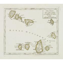
Les Isles du Cap-Verd. . .
Charming small map of the archipelago of Cape Verde. From Atlas Portatif Universel, by Robert de Vaugondy.From Atlas Portatif Universel, by Robert de Vaugondy.Page 87 out...
Date: Paris, later than 1748
Selling price: ????
Please login to see price!
Sold in 2011
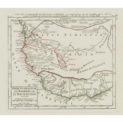
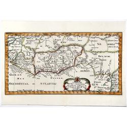
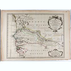
Partie Occidentale de la Nigritie et de la Haute Guinée.
Nice small map illustrating the West African shores between Mauritania and Benin. From Atlas Portatif Universel, by Robert de Vaugondy. 78, Pag.566 outside border top rig...
Date: Paris, later than 1749
Selling price: ????
Please login to see price!
Sold in 2013
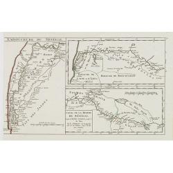
Cours de la Riviere de Sénégal. Depuis le Rocher Gouinea jusqu'à la Mer.
3 small maps in one plate. Illustrating the stretch of the Senegal River constituting the natural border between Senegal and Mauritania. Dated 1749.From Atlas Portatif Un...
Date: Paris, later than 1749
Selling price: ????
Please login to see price!
Sold in 2013
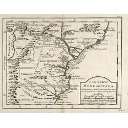
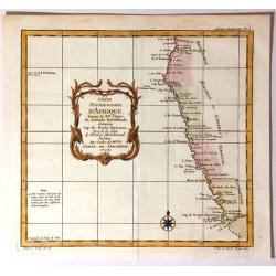
Das Reich der Monomotapa und dessen benachbarte Staaten.
Engraved map of Mozambique in Southeast Africa by Nicolas Bellin. From the German edition of Prévost's "L'Histoire Générale des Voyages" by J. J. Schwabe in ...
Date: Leipzig, 1749
Selling price: ????
Please login to see price!
Sold in 2009
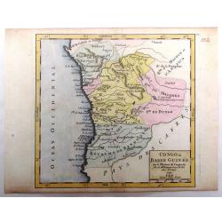
Congo ou Basse Guinee.
Little hand colored Vaugondy map featuring a section of the west coast of Africa, centered on Angola. It is from "Atlas Portatif, Universel et Militaire", publi...
Date: Paris, 1749
Selling price: ????
Please login to see price!
Sold in 2016
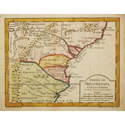
Empire du Monomotapa et Etats Voisins.
Jaques Nicolas Bellin (1702-720) was the most important French hydrographer of the 18th century. Sea-atlas 'Hydrographique Français' , 1756-65, atlas to accompany Prévo...
Date: Paris, c. 1750
Selling price: ????
Please login to see price!
Sold in 2008
