Browse Listings in Africa > Central Africa
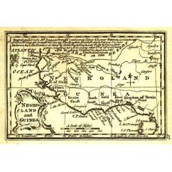
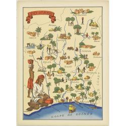
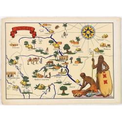
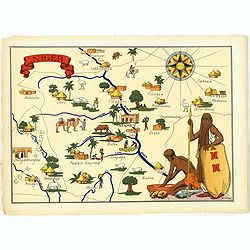
Negroland and Guinea. 1787
Negroland, or Nigritia, is an archaic and outdated term in European mapping, describing the inland and poorly explored region in West Africa as an area populated with neg...
Date: London, 1787
Selling price: ????
Please login to see price!
Sold in 2020
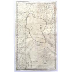
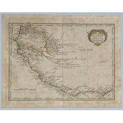
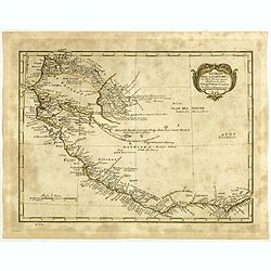
To My Worthy and Learned Friend the Honourable Daines Barrington This Plan of two Attempts to Arrive at the Source of the Nile is dedicated by his most Obliged and faithful Humble Servant James Bruce.
This is a significant, engraved, 1790 map of Ethiopia (Abyssinia) and the source of the Blue Nile by the Scottish adventurer James Bruce. Centered on Lake Tana (Tzana), t...
Date: London, 1790
Selling price: ????
Please login to see price!
Sold in 2017
Untitled Map of West Africa (Cyrillic)
A rare cyrillic edition of the Bonne & Lattré copper engraved map of West Africa. It covers from the Gold Coast (modern day Ghana), south around the Bight of Benin t...
Date: St Petersburg, 1790
Selling price: ????
Please login to see price!
Sold in 2019
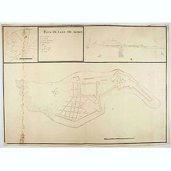
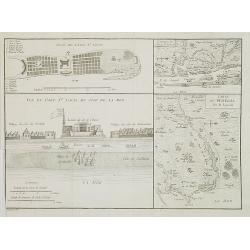
Plan de l'Isle de Goree.
A unusual map of the island of Goree. Includes an inset map of Senegalese coast, and a view of the port on the opposite upper corner. The title includes also a lettered k...
Date: ca. 1790
Selling price: ????
Please login to see price!
Sold in 2020
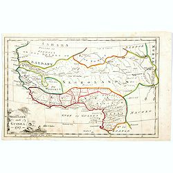
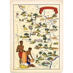
Negroland and Guinea.
Uncommon miniature map from Gibson's "Atlas Minimus, or a New Set of Pocket Maps of the several Empires, Kingdoms and States of the known World".
Date: London, 1792
Selling price: ????
Please login to see price!
Sold
![[Lot of 7 maps of the lands bordering the Red Sea]](/uploads/cache/20680-250x250.jpg)
[Lot of 7 maps of the lands bordering the Red Sea]
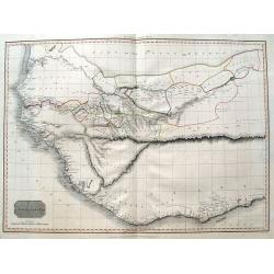
Jan Elwe’s re-issue of Guillaume de l’Isle’s 1707 map of the lands bordering the Red Sea, showing Arabia distinctively.Jan Berend Elwe. Amsterdam-based publisher. P...
Date: Paris, 1792
Selling price: ????
Please login to see price!
Sold in 2022
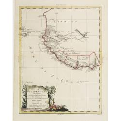
La Guinea Occidentalle..
An engraved chart of the coast from Sierra Leone to Cape delle Tre Punte.
Date: Venise, 1794
Selling price: ????
Please login to see price!
Sold in 2010
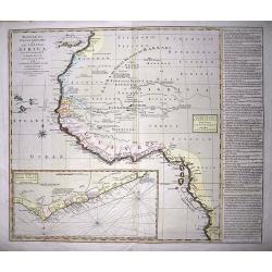
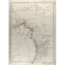
Bowles's new one-sheet map of the coast of Africa :from S.ta Cruz, lat. 30°N. to Angola, lat. 11°.S. with explanatory notes; and a correct chart of the Gold Coast.
Very interesting map of Western Africa, extending from the Canary Islands to Angola. Large scale with much information and interesting annotations. Lists Kingdoms and are...
Date: London, c1794
Selling price: ????
Please login to see price!
Sold in 2014
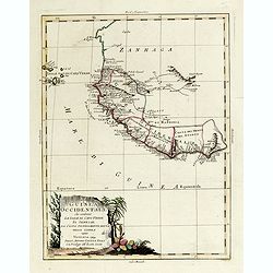
La Guinea Occidentale...
An engraved chart of the coast from Sierra Leone to Cape delle Tre Punte.
Date: Venise, 1794
Selling price: ????
Please login to see price!
Sold in 2018
Le Coste Dell' Alta Guinea.
A rare and detailed outline map of the coast of West Africa.
Date: Sienna, 1796
Selling price: ????
Please login to see price!
Sold in 2018
Le Coste Dell' Alta Guinea.
A rare and detailed outline map of the coast of West Africa beginning with the Gold Coast to the west and to Senegal to the north. Many slaves were exported from this reg...
Date: Siena, 1796
Selling price: ????
Please login to see price!
Sold in 2019
Carte de la Cote Ociidentale de l' Afrique.
A map showing the west Africa coasts, from Sierra Leone to Senegal and Gambia. Engraved by Tardieu. Shows all the up to then explored areas in the region.
Date: Paris, 1804
Selling price: ????
Please login to see price!
Sold in 2020
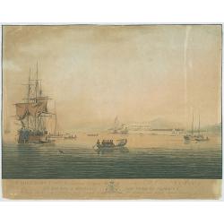
Cape Coast Castle, a British Settlement on the Gold Coast, Africa...
The image views Cape Coast Castle from the sea, it is positioned to the right of centre, a large ship is on the right with several smaller sailing ships, in the foregroun...
Date: G. Webster & J. Barrow, London Oct. 26th 1806
Selling price: ????
Please login to see price!
Sold in 2009
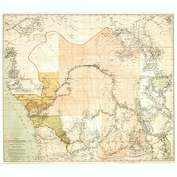
Western Africa.
Elephant folio sized map of Western Africa, extending from the Kingdom of Brak and Damel's Kingdom to the Gold Coast and the Slave Coast, and inland to Bibbie Lake, Jinba...
Date: London, 1813
Selling price: ????
Please login to see price!
Sold in 2016
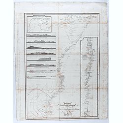
General chart of the East Coast of Africa from various Authorities and corrected by many
Detailed map of the east coast of Africa, supplemented by profiles and a detailed view of the coast from Mozambique to Cape Delgado. Drawn by John Outhett and engraved by...
Date: London, F.C. & J. Rivington, 1814
Selling price: ????
Please login to see price!
Sold in 2020
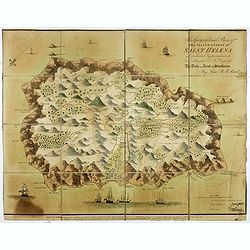
This Geographical Plan of the Island & Forts of St Helena is Dedicated by permission to Field Marshal His Ro.l Highness The Duke of Kent and Strathearn By Lieu.t R.P. Read.
FIRST EDITION. A map of the island of St Helena, decorated with trees, ships, cannons, residences, and even whales (perhaps sperm whales) firing powerful jets of water fr...
Date: London: Burgess & Barfoot, October 1815
Selling price: ????
Please login to see price!
Sold in 2021
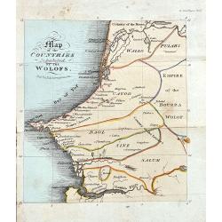
Map of the Countries Inhabited by the Wolofs
Rare map of Senegal and Gambia. The map is shows good detail of villages, regionas, and topographical features. Published in Ackermann's The World in Miniature. Africa.....
Date: London, 1822
Selling price: ????
Please login to see price!
Sold in 2022
Carte du Sénégal / Plan de l\'Isle St. Louis / Vue du Fort St. Louis du côté de la mer. / Environs de l' Isle St. Louis.
Four maps on one sheet showing the position of the French stronghold of Fort St. Louis in Senegal.
Date: Paris, ca. 1835
Selling price: ????
Please login to see price!
Sold in 2009
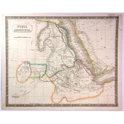
Nubia and Abyssinia
A pleasant map of Nubia and Abyssinia (Ethiopia) that covers from Darfur east to the Sea of Bab el Mandeb (Gulf of Aden) and from the Desert of Chebba south to Donga. Inc...
Date: London, 1835
Selling price: ????
Please login to see price!
Sold in 2016
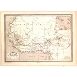
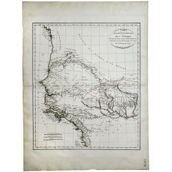
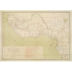
Afrique Occidentale Comprenant le Sahara, Le Soudan...
Detailed map of Western Africa including the Sahara Desert and the Soudan. Published by Aubree Armand in Paris in 1837. Engraved by I. Grenier and printed by Mangeon.Inse...
Date: Paris, 1837
Selling price: ????
Please login to see price!
Sold in 2015
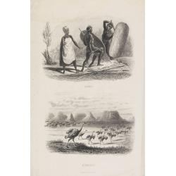
Cafres / Autruches
Two engraving for one sheet. Engraving depict typical warriors of Africa and Ostrich.
Date: Paris,1844
Selling price: ????
Please login to see price!
Sold in 2015
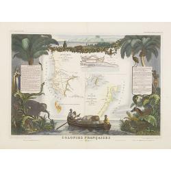
Colonies Françaises (en Afrique).
A very decorative 19th century map of western coast of Africa and includes a map of the coast of Madagascar. The map is surrounded by portraits, animals, vegetation, etc....
Date: Paris, 1850
Selling price: ????
Please login to see price!
Sold in 2018
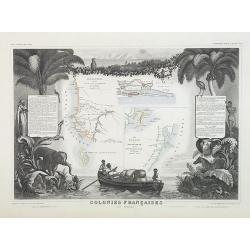
Colonies Françaises (en Afrique). N°91.
Handsome map divided into two sections shows a section of the coast of French West Africa titled 'Senegambie' (Senegal & Gambia) with a drawing of the Senegal River a...
Date: Paris, A. Combette, 1852
Selling price: ????
Please login to see price!
Sold in 2009
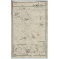
A Chart of the Cape Verde Islands, Drawn from the Latest Authorities by J.W. Norie, Hydrogrpher.
An original and striking, mariners chart of the Cape Verde Islands in the Atlantic Ocean, off the coast of Africa. It is by J. W. Norie one of the most important chart ma...
Date: London, 1855
Selling price: ????
Please login to see price!
Sold in 2018
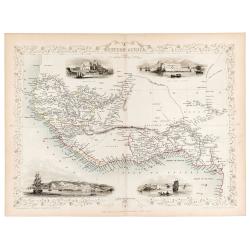
Western Africa.
Original steel engraved map of Western Africa. Map accompanied by vignette scenes of Christiansborg, Cape Coast Castle, Sierra Leone and Bakel. Decorative scrolling and t...
Date: London & New York: John Tallis & Company, 1856
Selling price: ????
Please login to see price!
Sold in 2023
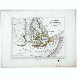
La Nubia E l'Abissinia . . .
Uncommon map of East coast of Africa with Sudan, Nubia and lower Nile, prepared by Francesco Costantino Marmocchi. Above the map "Geografia Commerciale". From &...
Date: Genova, Paolo Rivara fu Giacomo, 1858
Selling price: ????
Please login to see price!
Sold in 2021
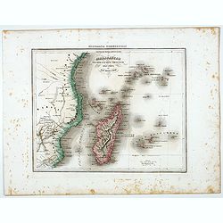
Madagascar e le Isole E le Coste Circonvicine Dell' Africa nel Mar Delle Indie.
Uncommon map of Madagascar, Seychelles, La Réunion and Mauritius and East Coast of Africa around Mozambique, prepared by Francesco Costantino Marmocchi. Above the map &q...
Date: Genova, Paolo Rivara fu Giacomo, 1858
Selling price: ????
Please login to see price!
Sold in 2022
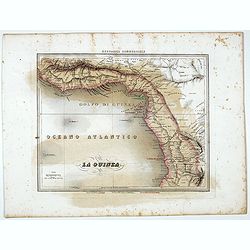
La Guinea.
Uncommon map of Guinea prepared by Francesco Costantino Marmocchi. Above the map "Geografia Commerciale". From "Il Globo Atlante di carte Geografiche compi...
Date: Genova, Paolo Rivara fu Giacomo, 1858
Selling price: ????
Please login to see price!
Sold in 2021
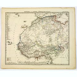
Mittel und Nord-Africa. Westl. Theil.
An informative and detailed map of middle, western and northern Africa, published in Gotha by Perthes in Stieler's Hand Atlas in 1863. It shows elevations, cities, tracks...
Date: Gotha, 1863
Selling price: ????
Please login to see price!
Sold in 2019
Karte des Kongobeckens und der angrenzenden Gebiete, zugleich Darstellung der Ausdehnung des Kongostaates. Von Henry M. Stanley.
Detailed map in a scale of 1:2.900.000 of the Congo Basin and the bordering regions, also showing the expansion of the State of the Congo. By Henry M. Stanley. Sir Henry ...
Date: Leipzig, 1877
Selling price: ????
Please login to see price!
Sold in 2020
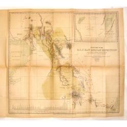
Route Map of the R.G.S. East African Expedition.
Fine map of East Africa published for the Proceedings of the Royal Geographical Society (R.G.S.). Mapmaker was E. Weller.The map area is from Mombasa to Mount Kenia &...
Date: London, 1884
Selling price: ????
Please login to see price!
Sold in 2014
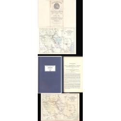
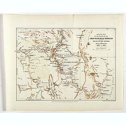
Sketch Map of the Route of the Emin Pasha Relief Expedition
A complete extract from the Proceedings of the Royal Geographical Society of June 1890, p313 ? 331, with the folding map as called for on p.372, now bound in blue covers ...
Date: London, 1890
Selling price: ????
Please login to see price!
Sold
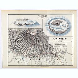
Kilima Njaro Mtn. to illustrate the paper of Dr. Hans Meyer.
One of the first maps of Mount Kilima Njaro with insets of the Bibo Crater, the route of dr. Hans Meyer shown in a red line.Fine colored lithograph map lithographed by F....
Date: London, Edward Stanford, 1890
Selling price: ????
Please login to see price!
Sold in 2017
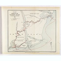
East Africa. Mounts of the Zambesi River surveyed by Daniel J.Rankin, M.R.A.S. 1889.
One of the first maps of the mouths of the Zambesi River surveyed by Daniel J.Rankin in 1889, his track shown in a red line.Fine colored lithograph map lithographed by Tu...
Date: London, Edward Stanford, 1890
Selling price: ????
Please login to see price!
Sold in 2019
Sketch map of the route of the Emin Pasha relief expedition from the mounth of the Aruwimi to Bagamyo 1887 to 1889.
One of the first maps of the Emin Pasha relief expedition route from the mouth of the Aruwimi to Bagamoyo 1887 to 1889, his track shown in a red line.Fine colored lithogr...
Date: London, Edward Stanford, 1890
Selling price: ????
Please login to see price!
Sold in 2017
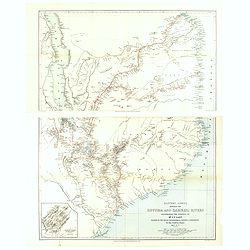
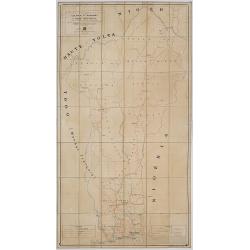
Eastern Africa beteween the Rovuma and Zambesi rivers illustrating the surveys of Mr. J.T. Last.. . .
Map in two sheets of the eastern part of Africa. The Royal Geographical Society (with the Institute of British Geographers) is the Learned Society representing Geography ...
Date: London, J.T Last, 1890
Selling price: ????
Please login to see price!
Sold in 2021
![[Title in Ottoman Turkish: WEST AFRICA AND THE MAGHREB].](/uploads/cache/44731-250x250.jpg)
[Title in Ottoman Turkish: WEST AFRICA AND THE MAGHREB].
A fine Ottoman map of West Africa and the Maghreb from Ali Seref Pasa’s rare ‘Yeni cografya atlasi’, published by the press of Matbaa-i Amire, the successor of Ibra...
Date: Beyazit, Istanbul: Matbaa-i Amire 1311 or 1895
Selling price: ????
Please login to see price!
Sold in 2019
Carte des Missions .. Du Soudan Français..
Uncommon and detailed map of Western part of Africa, prepared by P.Vuillot. The map has a key to the 19 different missionary territories. Published as a supplement to Jou...
Date: Lyon/Paris 1897
Selling price: ????
Please login to see price!
Sold
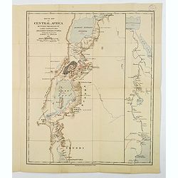
Sketch Map of Central Africa between the Region of Lake Tanganyika and Albert Edward Nyanza.
An attractive folding map titled "Sketch Map of Central Africa between the region of Lake Tanganyika and Albert Edward Nyanza, illustrating the Journey of Ewart S. G...
Date: London, 1900
Selling price: ????
Please login to see price!
Sold in 2019
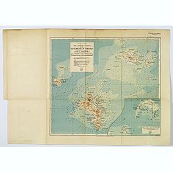
The Central Islands of the Seychelles Group. . .
A nice 'modern' map of the Seychelles, published 'to illustrate a paper by J. Stanley Gardiner, M.A.'. With a small reference table beneath the title and scales, inset of...
Date: London, 1907
Selling price: ????
Please login to see price!
Sold in 2019
![[Equatorial Africa - map with Ottoman script]](/uploads/cache/44739-250x250.jpg)
[Equatorial Africa - map with Ottoman script]
Postcard size map in Ottoman script of Equatorial Africa from Mehmet Eşref’s ‘Küçük Atlas’, a rare portfolio of loose-leaf postcard-sized maps with text in Ott...
Date: Istanbul, Şirket-i Mürettibiye ve Karacoğlu Matbaası 1325 or 1909
Selling price: ????
Please login to see price!
Sold in 2022
![[Equatorial Africa - map with Ottoman script]](/uploads/cache/44740-250x250.jpg)
[Equatorial Africa - map with Ottoman script]
Post card size map in Ottoman script of Sub-Saharan West Africa from Mehmet Esref’s ‘Küccük Atlas’, a rare portfolio of loose-leaf maps with text in Ottoman Turki...
Date: Istanbul, Matbaasi 1325 or 1909
Selling price: ????
Please login to see price!
Sold in 2019
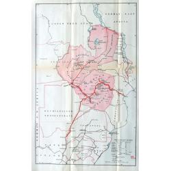
*untitled*
Very unusual and rare Railway map of todays Zimbabwe, parts of Mozambique, and parts of South Africa, parts of Congo and Tansania. Extends from Lake Tanganyika south unt...
Date: London, c1910
Selling price: ????
Please login to see price!
Sold in 2022
Colonie du Dahomey Carte Routiere dressée au service Géographique de l'A.O.F. Dakar.
Dissected and mounted on linen road map of Dahomey colony, on witch the limits of the state, the colony, and the circle are indicated.
Date: Paris, ca. 1928
Selling price: ????
Please login to see price!
Sold in 2017
Congo Nova Descriptio.
Beautiful and decorative pictorial map of Congo, showing different tribes of this area. The poster carries a wealth of information and presents a selection of traditional...
Date: Paris, 1930
Selling price: ????
Please login to see price!
Sold in 2021
Mission d'études du Haut fleuve Sénegal.
Five maps likely prepared by "La Mission d'Etudes du Fleuve Sénégal" (MEFS) which was a public body responsible for the conduct and execution of all th...
Date: Senegal, ca. 1935-1938
Selling price: ????
Please login to see price!
Sold in 2017
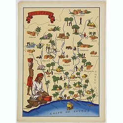
Cote d'Ivoire
Very decorative, informative map of the Ivory coast. The map is filled with buildings, animals, a ship, figures and two locals in their typical dress.In lower left corner...
Date: France, 1943
Selling price: ????
Please login to see price!
Sold in 2012
Oubangui-Chari.
Very decorative, informative map of Central Africa. The map is filled with buildings, animals, figures and two locals in their typical dress.In lower left corner "Im...
Date: France, 1943
Selling price: ????
Please login to see price!
Sold in 2018
Niger.
Very decorative, informative map of Nigeria. The map is filled with buildings, animals, figures and two locals. With a large compass rose in upper right corner.In lower l...
Date: France, 1943
Selling price: ????
Please login to see price!
Sold in 2018
Cote d'Ivoire
Very decorative, informative map of the Ivory coast. The map is filled with buildings, animals, a ship, figures and two locals in their typical dress.In lower left corner...
Date: France, 1943
Selling price: ????
Please login to see price!
Sold in 2016
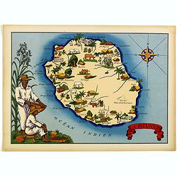
La Réunion.
Very decorative, informative map of the island of Reunion. The map is filled with buildings, animals, figures and two locals. With a large compass rose in upper right cor...
Date: France, 1943
Selling price: ????
Please login to see price!
Sold in 2018
Niger.
Very decorative, informative map of Nigeria. The map is filled with buildings, animals, figures and two locals. With a large compass rose in upper right corner.In lower l...
Date: France, 1943
Selling price: ????
Please login to see price!
Sold in 2016
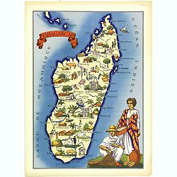
Madagascar.
Very decorative, informative map of Madagascar. The map is filled with buildings, animals, figures and two locals in their typical dress.In lower left corner "Imprim...
Date: France, 1943
Selling price: ????
Please login to see price!
Sold in 2018
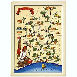
Cote d'Ivoire
Very decorative, informative map of the Ivory coast. The map is filled with buildings, animals, a ship, figures and two locals in their typical dress.In lower left corner...
Date: France, 1943
Selling price: ????
Please login to see price!
Sold in 2018
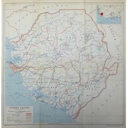
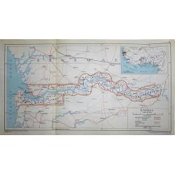
Sierra Leone
A 1948 map of Sierra Leone published by the Directorate of Colonial Surveys, and printed by the War Office.
Date: London, 1948
Selling price: ????
Please login to see price!
Sold in 2017
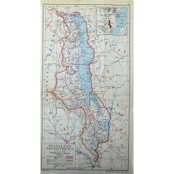
Nyasaland Protectorate
Nyasaland Protectorate published by the Directorate of Colonial Surveys, and printed by the War Office in 1948.
Date: London, 1948
Selling price: ????
Please login to see price!
Sold in 2017
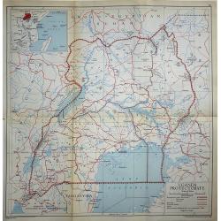
Uganda Protectorate
A 1948 map of Uganda under the British Protectorate, published by the Directorate of Colonial Surveys, and printed by the War Office.
Date: London, 1948
Selling price: ????
Please login to see price!
Sold in 2017
Gambia
A 1948 map of Gambia under the British Protectorate, published by the Directorate of Colonial Surveys, and printed by the War Office.
Date: London, 1948
Selling price: ????
Please login to see price!
Sold in 2017
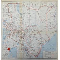
Kenya Colony
A 1948 map of the Kenya Colony, published by the Directorate of Colonial Surveys, printed by the War Office.
Date: London, 1948
Selling price: ????
Please login to see price!
Sold in 2017
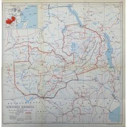
Northern Rhodesia
A 1948 map Northern Rhodesia published by the Directorate of Colonial Surveys, printed by the War Office.
Date: London, 1948
Selling price: ????
Please login to see price!
Sold in 2017
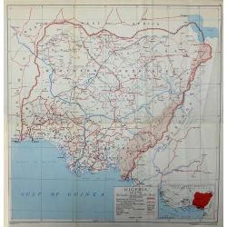
Nigeria
A 1948 map of Nigeria published by the Directorate of Colonial Surveys, printed by the War Office.
Date: London, 1948
Selling price: ????
Please login to see price!
Sold in 2017
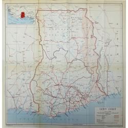
Gold Coast
The African Gold Coast published by the Directorate of Colonial Surveys, and printed by the War Office in 1948.
Date: London, 1948
Selling price: ????
Please login to see price!
Sold in 2017
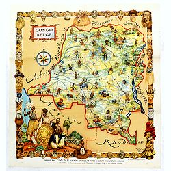
Congo Belge.
This poster was included in the picture book "Faunaflor-Kongo" of the chocolate manufacturer Côte D'or. Printed in Belgium by Ets. Leon Beyaert-Sioen N.V. Kort...
Date: Kortrijk, ca. Ca. 1950
Selling price: ????
Please login to see price!
Sold in 2019
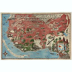
Afrique Occidentale Française AOF.
Beautiful and decorative lithograph pictorial map of French West Africa, showing tribes, animals, monuments, landscapes. Made for Ministere de la France d'Outre-mer, agen...
Date: Imprimerie Jombart, Asnières, ca. 1950
Selling price: ????
Please login to see price!
Sold in 2020
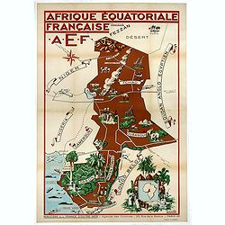
Afrique Equatoriale Française AEF.
Beautiful and decorative lithograph pictorial map of Equatorial Africa, showing tribes, animals, landscapes… Made for Ministere de la France d'Outre-mer, agence des Col...
Date: Imprimerie Jombart, Asnières, ca. 1951
Selling price: ????
Please login to see price!
Sold in 2020
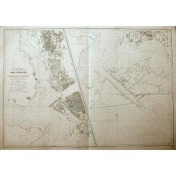
Port d'Abidjan.
An unusual sea-chart of Abidjan, Côte d'Ivoire. With excellent detail of the coasts, and the city. The left chart shows the harbour, and the chart on the right shows the...
Date: Paris, 1965
Selling price: ????
Please login to see price!
Sold in 2018
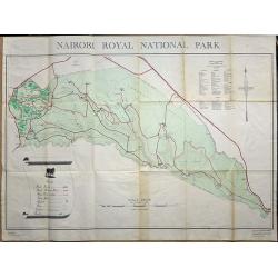
Nairobi Royal National Park.
A large plan of Nairobi National Park, first edition September 1956. A key shows the physical make up of the park plus a list of Mammals and Reptiles found in the park.
Date: Nairobi, 1956
Selling price: ????
Please login to see price!
Sold in 2019
