Browse Listings in Africa
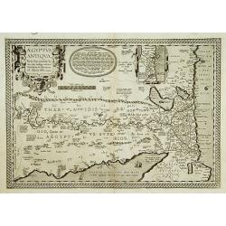
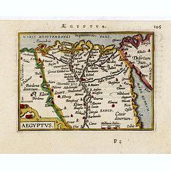
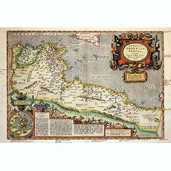
Aegyptus Antiqua.
A splendid map of ancient Egypt, which appeared in Ortelius' Parergon. The map is based on his separately published map of Egypt, published in 1565, but with differences ...
Date: Antwerp 1595
Selling price: ????
Please login to see price!
Sold
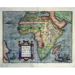
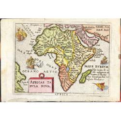
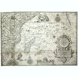
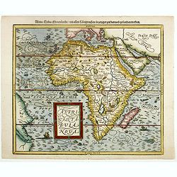
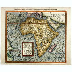
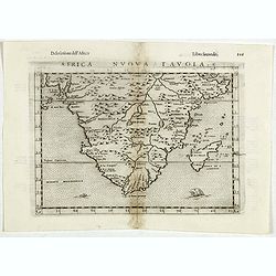
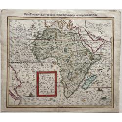
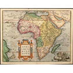
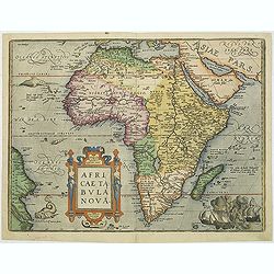
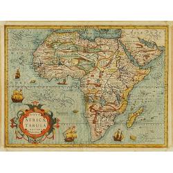
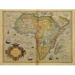
Africae Tabula Nova Edita Antverpiae 1570.
Collectible example of one of the cornerstone maps of Africa. A beautiful map in original color. Ortelius' map was modern in appearance, compared to Munster and o...
Date: Antwerp, (1570) 1595
Selling price: ????
Please login to see price!
Sold
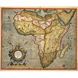
Africa ex magna orbis terre descriptione Gerardi Mercatories desumpta studio & industria G.M. Juniorius
A classic and important map of Africa, especially as it is directly based on Gerard Mercator’s rare wall map of the world of 1569. The map first appeared in Gerard Merc...
Date: Duisburg and then Amsterdam, 1595
Selling price: ????
Please login to see price!
Sold in 2017
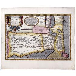
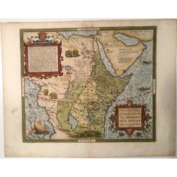
AEGYPTUS ANTIQUA. Terra suis contante bonis, non indiga mercis. . .
A splendid map of ancient Egypt, which appeared in Ortelius' Parergon. The map is based on his separately published map of Egypt, published in 1565, but with differences ...
Date: Antwerp, 1595
Selling price: ????
Please login to see price!
Sold in 2020
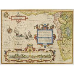
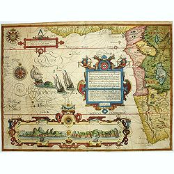
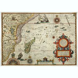
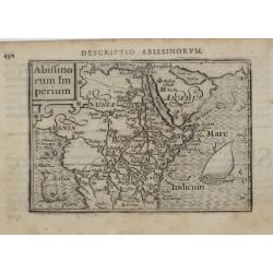
Presbiteri Johannis sive Abissinorum Imperii Descriptio
Very decorative example of Ortelius' famous map of the Kingdom of Prester John, from a Latin edition of Ortelius' Theatrum Orbis Terrarum, the first modern atlas of the w...
Date: Amverpen, 1595
Selling price: ????
Please login to see price!
Sold in 2023
![[Lot of 9 maps/ prints of Egypt ] Aegypti Recentior Descriptio / Carthaginis Celeberrimi Sinus Typus.](/uploads/cache/18309-(8)-250x250.jpg)
[Lot of 9 maps/ prints of Egypt ] Aegypti Recentior Descriptio / Carthaginis Celeberrimi Sinus Typus.
Abraham Ortelius' maps of Egypt and Carthago on one sheet.Abraham Ortelius(1527-98), Dutch cartographer and publisher of the first modern atlas, ' Theatrum Orbis Terrarum...
Date: Antwerp, 1595
Selling price: ????
Please login to see price!
Sold in 2023
AFRICA.
This is Giovanni Magini's modern map of Africa from his edition of Claudius Ptolemy's Geographia. It is basically a slightly-reduced version of the D'Anania 1582 map of...
Date: Venice, 1596
Selling price: ????
Please login to see price!
Sold in 2013
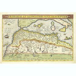
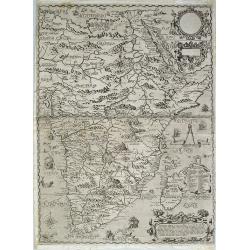
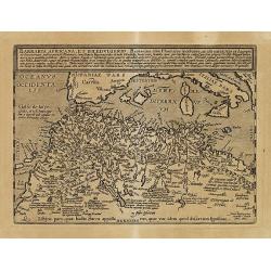
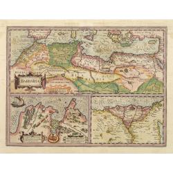
Barbariae et Biledulgerid, nova descriptio.
North-West Africa. Koeman speculated: In view of the important trading relationship between Antwerp and Africa, it is not impossible that the original was a manuscript ma...
Date: Amsterdam, 1596
Selling price: ????
Please login to see price!
Sold
Vera effigies et delineatio Insulae Ascenscio nuncupatae sitae in altitudine 8 graduum ad austrum lineae aequinoctialis.
This is Linschoten's map of Ascension Island in the south Atlantic, beautifully engraved by Baptista a Doetechum.Decorative print showing three coastal views of Ascension...
Date: Amsterdam, c.1596
Selling price: ????
Please login to see price!
Sold in 2012
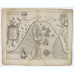
Insulae et arcis MOCAMBIQUE descriptio...Beschrijuinge des..
This is a finely executed copperplate engraved map of Mozambique Island, a strategically important re-supply point for the Portuguese empire in Asia during the 16th centu...
Date: Amsterdam, 1596
Selling price: ????
Please login to see price!
Sold in 2013
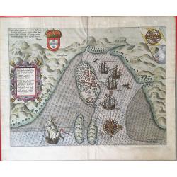
Insulae et arcis Mocambique descriptio ad fines Melinde.
An attractive and rare bird's-eye view of Melinde harbour in Mozambique, engraved by Jan Deutecum for Linschoten's 'Itinerario', published between 1596 and 1644. Probably...
Date: Amstrerdam, 1596
Selling price: ????
Please login to see price!
Sold in 2020
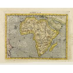
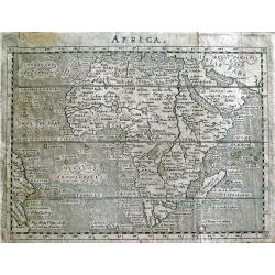
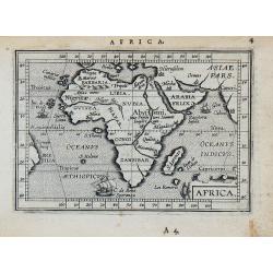
Africa.
Small map of Africa and the Arabian Peninsula showing part of Brazil as well.The rivers of central and north Africa feature prominently including the Ptolemaic concept of...
Date: Cologne 1597
Selling price: ????
Please login to see price!
Sold
Africa.
From "Geografia". Published in Venice by Galignani. Situated in a text page, with a gold leaf initial. Maps are engraved by Girolamo Porro.
Date: Venice, ca. 1597
Selling price: ????
Please login to see price!
Sold in 2008
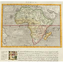
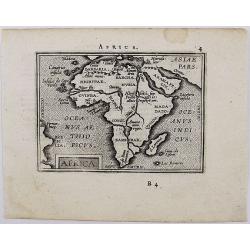
Africa Tertia pars Terrae.
This map of Africa has an unusual shape, tapering to a narrow angle in the south. Numerous rivers appear in West Africa and as tributaries to the Nile, and mountain chain...
Date: Magdeburg, ca 1597
Selling price: ????
Please login to see price!
Sold in 2025
Africae Tabula Nova
From the Ortelius miniature atlas 'Epitome theatri Orteliani' published by Philip Galle. Colored in nice, period correct color. Printers crease running through West Afric...
Date: Antwerp, ca 1598
Selling price: ????
Please login to see price!
Sold
Affbeeldinghe der custen des landts...Terra do Natal.
A superbly decorative early chart engraved by Arnold van Langren showing the African coastline of the Indian Ocean from the Cape to Natal, Mozambique and Madagascar. From...
Date: Amsterdam 1598
Selling price: ????
Please login to see price!
Sold
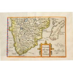
Regnum Monomotapae.
Metellus Rare Map of Southern Africa, from a 1598 Latin edition of Botero's "Theatrum Principum Orbis Universi". Modelled on the southern section of Mercator's ...
Date: Cologne, 1598
Selling price: ????
Please login to see price!
Sold in 2008
Affbeeldinghe der custen des landts Guinea, Manicongo..
A superbly decorative early engraved by Arnold Van Langren. The ocean is filled with superbly engraved compass spurs, Dutch galleons and elaborate strapwork cartouches. ...
Date: Amsterdam, 1598
Selling price: ????
Please login to see price!
Sold in 2008
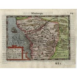
Congi Regni Christiani in Africa.
A fine early miniature map of the West coast of Africa, this map is from the first edition of the Langenes atlas (later well known under the name of Bertius). Dutch text ...
Date: Middelburg, 1598
Selling price: ????
Please login to see price!
Sold in 2014

Carthaginensis sinus.
Very fine early miniature map showing Tunis and its surroundings. The sea is embellished with a ship and a sea monster. The map depicts the ancient site of Carthage with ...
Date: Middelburg, 1598
Selling price: ????
Please login to see price!
Sold in 2014
Filippo Pigafetta-De Bry Map of Africa.
This is the De Bry version of the Pigafetta map of Africa. It is a close copy of the Pigafetta map. Pigafetta wrote a book entitled Relatione del reame di Congo et del...
Date: Frankfurt, 1598
Selling price: ????
Please login to see price!
Sold in 2010
![[ Map of Africa ]](/uploads/cache/99986-250x250.jpg)
[ Map of Africa ]
Extremly rare map of Africa, engraved by William Rogers and published by John Wolfe. The map occurs in the 1598 English edition of Jan Huyghen van Linschoten's Itinerario...
Date: London, John Wolfe, 1598
Selling price: ????
Please login to see price!
Sold in 2011
Affbeeldinghe der custen des landts...Terra do Natal.
A superbly decorative early chart engraved by Arnold van Langren showing the African coastline of the Indian Ocean from the Cape to Natal, Mozambique and Madagascar. From...
Date: Amsterdam, 1598
Selling price: ????
Please login to see price!
Sold in 2011
Affbeeldinghe der custen des landts Guinea, Manicongo. . .
A superbly decorative early chart engraved by Arnold van Langren. The ocean is filled with superbly engraved compass spurs, Dutch galleons and elaborate strapwork cartouc...
Date: Amsterdam, 1598
Selling price: ????
Please login to see price!
Sold in 2011
Aegyptus.
Very fine early miniature map of Egypt, showing the Nile delta . Title cartouche on the lower left corner. Scarce miniature map from the second series of miniature atlas ...
Date: Antwerp, 1598
Selling price: ????
Please login to see price!
Sold in 2015
Affbeeldinghe der custen des landts. . .Terra do Natal.
A superbly decorative early chart engraved by Arnold van Langren showing the African coastline of the Indian Ocean from the Cape to Natal, Mozambique and Madagascar. From...
Date: Amsterdam, 1598
Selling price: ????
Please login to see price!
Sold in 2015
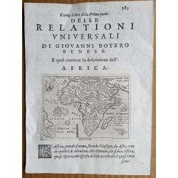
Africa Tabula Nova.
Africa continent map by Ortelius, used in Giovanni Botero (1533–1617)'s work "RELATIONI UNIVERSALI DI GIOVANNI BOTERO BENESE" issued in Venice by Giorgio Ang...
Date: Venice, c.1598
Selling price: ????
Please login to see price!
Sold in 2016
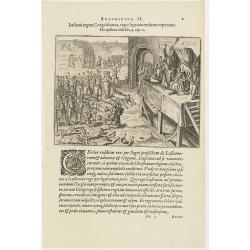
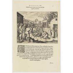
Argumentum II. Lufitani regem Congi falutant, eique legationem fuam exponunt. De quibus Vide lib. 2 cap 2.
The Portuguese appear before the king of the Congo. When the king of the Congo heard about his neighbor, the prince of Sogno, being converted to Christianity, he called t...
Date: Frankfurt, 1598
Selling price: ????
Please login to see price!
Sold in 2019
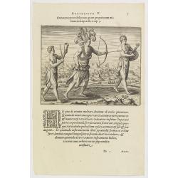
Argumentum V. Armatura tam nobiliorum quam gregariorum militum descripta lib. 1. cap. 7. (How the Congolese dress for war and play)
The distinguished inhabitants of the Congo decorate their head-dresses with ostrich, peacock or other feathers and, wound cross-wise across their bare chests they have ch...
Date: Frankfurt, 1598
Selling price: ????
Please login to see price!
Sold in 2016
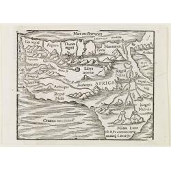
Africae tabula nova / Africa, Lybia, Morenlandt, mit allen Königreichen so jetziger zeit darumb gefunden werden. . .
Attractive woodcut map showing the African continent. From the 1598-German edition of Cosmographia by Sebastian Münster. German text on verso. This woodblock map is eleg...
Date: Basle, 1598
Selling price: ????
Please login to see price!
Sold in 2016
Africae tabula nova / Africa, Lybia, Morenlandt, mit allen Königreichen so jetziger zeit darumb gefunden werden. . .
Attractive woodcut map showing the African continent. From the 1598-German edition of Cosmographia by Sebastian Münster. German text on verso. This woodblock map is eleg...
Date: Basle, 1598
Selling price: ????
Please login to see price!
Sold in 2018
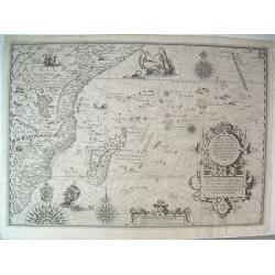
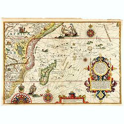
Delineatio orarum maritimarum, terræ vulgo indigetatæ terræ do Natal, item Sofalæ, Mozambicæ & Melindæ, insulæque Sancti Laurentii. . . / Affbeeldinghe der custen des landts genaempt terra do Natal, item van alle de custen...
A superbly decorative early chart engraved by Arnold van Langren showing the African coastline of the Indian Ocean from the Cape to Natal, Mozambique and Madagascar. Tool...
Date: Amsterdam, 1598
Selling price: ????
Please login to see price!
Sold in 2022
Africa Nuova Tavola.
Fine 1598 edition of this early map of southern Africa. Girolamo Ruscelli first published the map in his "La Geographi di Claudio Tolomeo" (Venice, 1561), with ...
Date: Venice, 1598
Selling price: ????
Please login to see price!
Sold in 2021
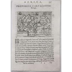
Provincia Cartaginese. Tunigi.
An attractive small map of the environs of Tunis in Northern Africa. It is from the "Relationi Universale" by Botero, published in Venice in 1598. Woodcut in pa...
Date: Venice, 1598
Selling price: ????
Please login to see price!
Sold in 2017
Fessae et Marocchi regna Africae celeberr.
Uncommon map, covering north-western Africa, with the Canaries and Madeira. With an inset of the Congo, after Filippo Pigafetta's famous map of the kingdom. Dare to go...
Date: Antwerp, 1598
Selling price: ????
Please login to see price!
Sold in 2020
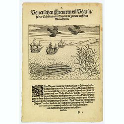
Seaweed and birds seen approaching the Cape of Good Hope.
The sailors saw many plants floating on the surface of the sea during their voyage to India. Among these was the ‘trombas’, which was a pipe-like growth with its root...
Date: Frankfurt, 1598
Selling price: ????
Please login to see price!
Sold in 2019
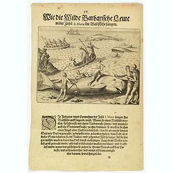
How the inhabitants catch whales off the east coast of Madagascar.
When the natives of Santa Marta, off the east coast of Madagascar see a whale, they row out in their little boats and throw out a rope with a large hook on the end. When ...
Date: Frankfurt, 1598
Selling price: ????
Please login to see price!
Sold in 2022
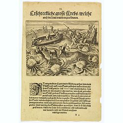
The Dutch are attacked by giant crabs.
During their return voyage, the Portuguese were wrecked on a sandbank (the Seychelles?) From the debris, they began building a smaller ship in which they hoped to return ...
Date: Frankfurt, 1598
Selling price: ????
Please login to see price!
Sold in 2026
Africa minor nuova tavola.
The third state of Ruscelli's map of North Africa, based upon Claudius Ptolemy. Showing the region of present day Algiers, Tunisia and Libya. Girolamo Ruscelli first publ...
Date: Venice, 1598
Selling price: ????
Please login to see price!
Sold in 2018
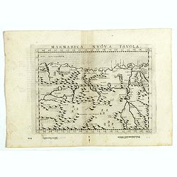
Marmarica nuova tavola.
The third state of Ruscelli's map of northern Africa based upon Claudius Ptolemy. Showing the Nubia Desert and showing Egypt, the Nile, etc. Girolamo Ruscelli first publi...
Date: Venice, 1598
Selling price: ????
Please login to see price!
Sold in 2018
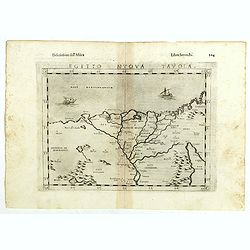
Egito vuova tavola.
The third state of Ruscelli's map of Egypt with the river Nile, based upon Claudius Ptolemy. Showing Egypt and the Nile. Extends east to the Upper Red Sea and West to Des...
Date: Venice, 1598
Selling price: ????
Please login to see price!
Sold in 2018
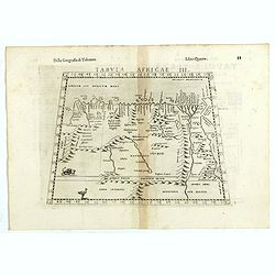
Tabula Africae III.
The third state of Ruscelli's map of North Africa and the Mediterranean, based upon Claudius Ptolemy. Showing the north coast of Africa including Egypt and the Nile River...
Date: Venice, 1598
Selling price: ????
Please login to see price!
Sold in 2018
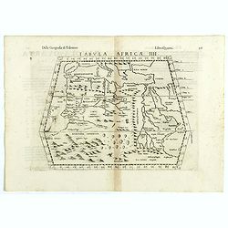
Tabula Africae IIII.
The third state of Ruscelli's map of The Northern part of Africa, based upon Claudius Ptolemy. Showing Mediterranean, Aethiopia Interior, the Canary Islands, Asia Minor, ...
Date: Venice, 1598
Selling price: ????
Please login to see price!
Sold in 2018
Delineatio orarum maritimarum, terræ vulgo indigetatæ terræ do Natal, item Sofalæ, Mozambicæ & Melindæ, insulæque Sancti Laurentii. . . / Affbeeldinghe der custen des landts genaempt terra do Natal, item van alle de custen van Coffala, Mozambique. .
A superbly decorative early chart engraved by Arnold van Langren showing the African coastline of the Indian Ocean from the Cape to Natal, Mozambique and Madagascar. Tool...
Date: Amsterdam, 1598
Selling price: ????
Please login to see price!
Sold in 2020
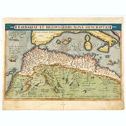
Barbariae et Biledulgerid, nova descriptio.
North-West Africa. Koeman speculated: In view of the important trading relationship between Antwerp and Africa, it is not impossible that the original was a manuscript ma...
Date: Antwerp, 1598
Selling price: ????
Please login to see price!
Sold in 2021
Afrika Tabula Nova
Woodcut map of the African continent: Münster second map of Africa, based upon Ortelius' map of 1570, from the German edition of Sebastian Münster's 'Cosmographey: das ...
Date: Basel, 1598
Selling price: ????
Please login to see price!
Sold in 2023
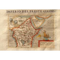
Imperio Del Preste Gianni - Presbeteri Ioannis Sive Abissinorum Imperii Descriptio.
Charming map of the legendary land of the Christian king, Prester John, inset in Italian text (recto and verso). From "La seconda parte delle relazioni universali&qu...
Date: Breschia c. 1599
Selling price: ????
Please login to see price!
Sold in 2011
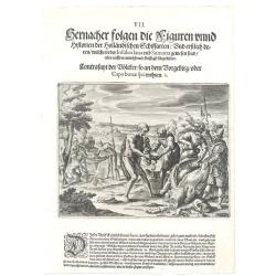
Edicti Regii, de quo cap. 3 fecundi libri agitur, executio. (How the king of the Congo had all the devilish idols burnt )
How the king of the Congo had all the devilish idols burnt. After the king of the Congo adopted the Christian religion, he told all his noblemen and servants to hand over...
Date: Frankfurt, 1598-1599
Selling price: ????
Please login to see price!
Sold in 2017
Africa.
A woodcut map of the African continent from a French edition of Cosmographia by Sebastian Münster. The map shows most of Africa including the supposed source of the Nile...
Date: Basle 1600
Selling price: ????
Please login to see price!
Sold
Abiffinorum Imperium
After A. Ortelius.
Date: Antwerp, c. 1600
Selling price: ????
Please login to see price!
Sold
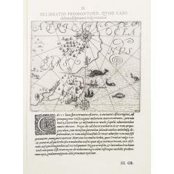
II. Delineatio Promontorii, qvod Cabo de bona Esperanca vulgo vocatur.
One of the earliest map of Cape of Good Hope region.
Date: Frankfurt 1600
Selling price: ????
Please login to see price!
Sold
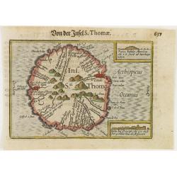
Ins. Sti. Thome
Early miniature map of Saint Thomas from the Caert-Thresoor and engraved by the Dutch master-engraver Petrus Kaerius. The first edition was printed in Middelburg by Baren...
Date: Amsterdam, 1600
Selling price: ????
Please login to see price!
Sold in 2008
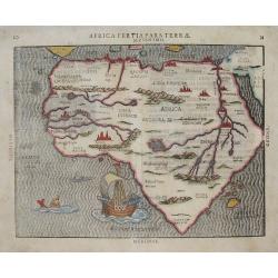
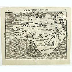
AFRICA TERTIA PARS TERRÆ .
This map is one of the later woodcut maps of Africa. As such, the appearance of the map, especially when compared to other maps from this period, is unusual. Like Bünt...
Date: Magdeburg, (1589) 1600
Selling price: ????
Please login to see price!
Sold in 2013
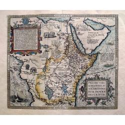
Presbiteri Iohannis, sive, Abissinorum Imperii descriptio.
Famous "Prester John" map of most parts of the African continent, and the Arabian peninsula. With a dedication to King David, and the coat of arms of Preste...
Date: Antwerp, c1600
Selling price: ????
Please login to see price!
Sold in 2013
The inhabitants of the Cape of Good Hope
This is the first print to show the inhabitants of the Cape together with Europeans, and one of the first large scale prints of the native peoples of the Cape..The plate ...
Date: Frankfurt 1601
Selling price: ????
Please login to see price!
Sold
Africa.
Miniature map of Africa. Strapwork title cartouche. Latin text on verso.
Date: Antwerp, 1601
Selling price: ????
Please login to see price!
Sold in 2010
Africa.
The miniature map of Africa based on Ortelius' larger map. It comes from the Latin edition of pocket-size atlas "Epitome Theatri Orteliani" engraved by Philip G...
Date: Antwerp, 1601
Selling price: ????
Please login to see price!
Sold in 2020
Congi Regni Chriffiani in Africa
Based on the geographical data of Philippo Pigafetta
Date: Amsterdam, c. 1602
Selling price: ????
Please login to see price!
Sold
Fessae, et Marocchi Regna Africae Celeberr. describebat Abrah. Ortelius. 1595.
Uncommon map, covering north-western Africa, with the Canaries and Madeira. With an inset of the Congo, after Filippo Pigafetta's famous map of the kingdom.
Date: Antwerp, 1602
Selling price: ????
Please login to see price!
Sold in 2017
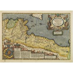
Africae propriae Tabula..
The most beautiful early map of the northern coast of Africa available to the collector. Prepared by Ortelius himself. Ortelius based the map on Gastaldi.
Date: Antwerp 1603
Selling price: ????
Please login to see price!
Sold
Africae Tabula Nova
Beautiful hand colored map of the African continent. From the 1603 Latin edition of Theatrum Orbis Terrarum by Abraham Ortelius. Fifth state of the copperplate, still the...
Date: Antwerp, 1603
Selling price: ????
Please login to see price!
Sold in 2009
Barbaria Africana, et Biledulgerid. . .
Uncommon map showing the south of Spain, and the northwest of Africa, with Morocco, Algeria, Tunisia. With the Canary Islands in the outer left.
Date: Cologne, Bussemacher, 1603
Selling price: ????
Please login to see price!
Sold in 2011
Africae Tabula Nova.
Dated 1570. Ortelius' depiction of Africa is based on Gastaldi's rare wall map of 1564, though with modifications such as the more pointed southern tip of the continent. ...
Date: Antwerp, 1603
Selling price: ????
Please login to see price!
Sold in 2011
Africae propriae Tabula..
The most beautiful early map of the northern coast of Africa available to the collector. Prepared by Ortelius himself. Ortelius based the map on Gastaldi.
Date: Antwerp, 1603
Selling price: ????
Please login to see price!
Sold in 2018
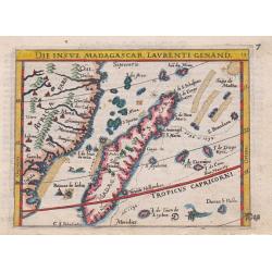
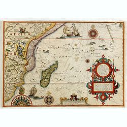
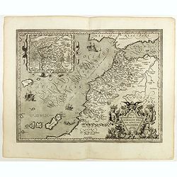
Die Insul Madagascar, Laurenti Genand.
An attractive miniature copper-engraved map of Madagascar from the German edition of Abraham Ortelius' Epitome, With German title at the top, a ship, two sea-monsters and...
Date: Frankfurt, 1604
Selling price: ????
Please login to see price!
Sold in 2015
Nova AFRICAE TABULA Auctore Jodoco Hondio.
The Hondius Africa was based on Mercator but the coastline, particularly of Madagascar, was considerably altered. Jodocus also made improvements in the Cape area.
Date: Amsterdam 1606
Selling price: ????
Please login to see price!
Sold
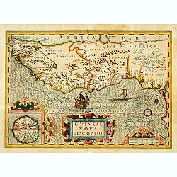
GUINEAE Nova Descriptio.
"The map shows the west coast from Senegal (Rio Senego) to Cape Lopez, just below the equator, and includes Guinea, with a portion of the Benin kingdom and of Lybia....
Date: Amsterdam, 1606
Selling price: ????
Please login to see price!
Sold
Nova Africae Tabula Auctore Jodoco Hondio.
The Hondius Africa was based on Mercator but the coastline, particularly of Madagascar, was considerably altered. Jodocus also made improvements in the Cape area.Presents...
Date: Amsterdam 1606
Selling price: ????
Please login to see price!
Sold
Barbaria/ Egypt/ Tunesia.
Upper map showing the Northern African coast, including Cyprus, Greece and Sicily. Lower part maps of Tunis and Nile Delta.
Date: Amsterdam, 1606
Selling price: ????
Please login to see price!
Sold
![[Two sheet map of Africa.]](/uploads/cache/35242-250x250.jpg)
[Two sheet map of Africa.]
Very rare map of Africa in two separate sheets, when joined 385x373mm, published by Levinus Hulsius. This is the second state with below the scale "C. de lopo Gonsal...
Date: Nuremberg, (1602)1606
Selling price: ????
Please login to see price!
Sold in 2022
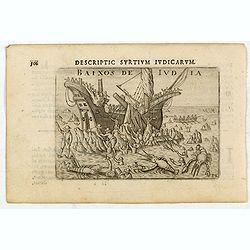
Baixos de Iudia.
Early miniature view of a shipwreck on the islands located between Madagascar and Mozambique. In the foreground, a kind of big lobsters are catching shipwrecked passenger...
Date: Amsterdam, Cornelis Claes, 1606
Selling price: ????
Please login to see price!
Sold in 2020
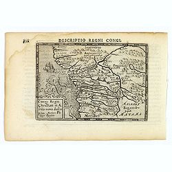
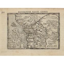
Descriptio Regni Congi.
An attractive miniature map of the Christian Kingdom of Congo in western Africa, published by Petrus Bertius, in Amsterdam at the beginning of the seventeenth century. It...
Date: Amsterdam, 1606
Selling price: ????
Please login to see price!
Sold in 2021
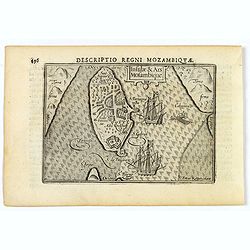
Insulae & Ars Mosambique.
An very attractive miniature map of the Portuguese island of Mozambique in east Africa, published by Petrus Bertius, in Amsterdam at the beginning of the seventeenth cent...
Date: Amsterdam, 1606
Selling price: ????
Please login to see price!
Sold in 2023
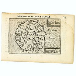
St. Thomas.
A lovely miniature map of the one time Portuguese island of St. Thomas, published by Petrus Bertius, in Amsterdam at the beginning of the seventeenth century. The island ...
Date: Amsterdam, 1606
Selling price: ????
Please login to see price!
Sold in 2023
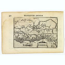
Guinea.
A fine miniature map of the west African region of Guinea, published by Petrus Bertius in Amsterdam early in the seventeenth century. The map and has a strap-work title, ...
Date: Amsterdam, 1606
Selling price: ????
Please login to see price!
Sold in 2019
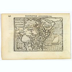
Abissinorum Imperium.
A fine miniature map of the "Empire of Abyssinia", home to the mythical Christian king, Prester John, published by Petrus Bertius in Amsterdam early in the seve...
Date: Amsterdam, 1606
Selling price: ????
Please login to see price!
Sold in 2019
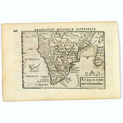
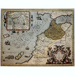
Africae pars meridionalior.
A fine miniature map of central and southern Africa, published by Petrus Bertius in Amsterdam early in the seventeenth century. The lovely map and has a strap-work title,...
Date: Amsterdam, 1606
Selling price: ????
Please login to see price!
Sold in 2019
![I.S. Laurentij. [Madagasgar]](/uploads/cache/43290-250x250.jpg)
I.S. Laurentij. [Madagasgar]
A nice miniature map of the Indian Ocean island of Madagasgar, published by Petrus Bertius in Amsterdam early in the seventeenth century. North is orientated to the left....
Date: Amsterdam, 1606
Selling price: ????
Please login to see price!
Sold in 2021
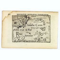
Descriptio Insularum Canariarum.
A beautiful miniature map by Bertius shows the Canary islands with Palma, Gomera, Ferro, Tenerifa, Gran Canaria, Forte Ventura and Lanzerote. Decorative, ornamental title...
Date: Amsterdam, 1606
Selling price: ????
Please login to see price!
Sold in 2019
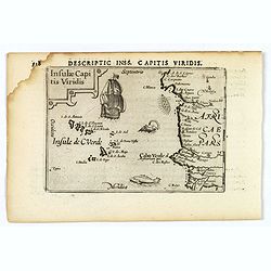
Insulae Capitis Viridis.
A nice early miniature map by Petrus Bertius of the Cape Verde islands in the Atlantic Ocean, off the coast of Africa. With a decorative, strap-work title cartouche, a g...
Date: Amsterdam, 1606
Selling price: ????
Please login to see price!
Sold in 2021
