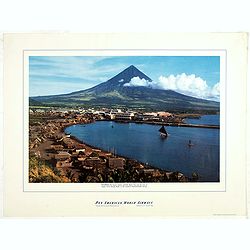
Recently Listed Listings in Asia

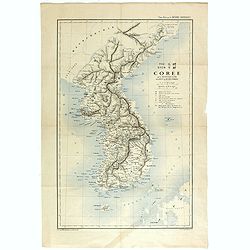
Partie de la Chine. N°.74 (Including South Korea)
Covering the Mouth of the Yangtze area in Jiangsu and Zhejiang, and southwestern Korea with the island of Quelpart (Jeju-do). Shows explorers' routes, including La Perou...
Date: Brussels, 1825-1827

Map of China.
Showing China, Taiwan and Korea, divided into provinces with the main cities marked. The map is of interest for the use of Sea of Corea, the sea between Korea and Japan, ...
Date: London, 1804

Carte du Katay ou Empire de Kin. . .
The map is of interest for the use of Mer de Corée for the sea between Korea and Japan. Fine map of Korea and China's Yellow Sea. Complete title in top: Carte du Katay o...
Date: Paris, 1750

La China e Giapone.
Uncommon map of China, Korea, Japan and Taiwan (I.Formosa), only one town labeled, Tayoan. Very strange shape for Japan.The map is of interest for the use of Mar di Corea...
Date: Italy, ca. 1800

Le Japon.
The map is of interest for the use of Mer de Corée, for the sea between Korea and Japan. Small detailed map of Japan and Korea. Dated 1749. A note next to island &quo...
Date: Paris, 1749

Paradigma XV Provinciarum et CLV Urbium Capitalium Sinensis Imperij Cum Templis quae Cruce X Signatur Et Domiciliis S.I.
First edition of this rare Jesuit map of China, published by Jean Baptiste Nolin in Paris and based on Philippe Couplet's map of 1686. The map shows China's 15 provinces ...
Date: Paris, 1686

Un Reclutatore in India. Papagallo No. 42. Anno VI.
A British recruter in India. Design by Augusto Grossi. Taken from the Italian satirical newspaper Il Papagallo, a satirical magazine founded in January 1873 by Augusto Gr...
Date: Bologne, 1878

Chosen Danpan - Korean negotiation.
A scene of a Japanese legation under the command of Hanabusa Yoshitada who is forcing the Korean King Kojong (1852-1919) to agree to Japanese demands during the Chemulpo ...
Date: August 8, MEIJI 27th year or 1894
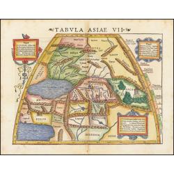
Tabula Asiae VII.
Attractive woodblock map, depicting the Caspian Sea, Black Sea and the Persian Gulf, extending to the Imaus Mountains. according to Ptolemy. In the center of the map is...
Date: Basle, 1542

Kaart van Palestina voor oud- en nieuw testament behorend bij de weg met en naar Christus door Fr. M. Bellarminus.
Original vintage illustrated map wall map sized poster (166 x 118cm) of Palestine in the time of Christ featuring a map of the old and new testament of the Bible from The...
Date: Utrecht, Sint Gregoriushuis, 1948
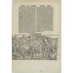
Constatinopolis.
Panoramic town-view of Constantinople (Istanbul). Woodcut published in the so-called pirate edition of the "small Schedel" in Augsburg, 1497, Latin edition. Ori...
Date: Augsburg, Johann Schönsperger. 1497

A chart of the China Sea inscribed to Monsr. D'APRES de MANNEVILLETTE .. To A.Dalrymple.
This most important milestone chart is based upon the surveys made from navigational surveys by Alexander Dalrymple (1737-1808]. He was the first hydrographer of the Brit...
Date: Paris, ca 1775

Quantung, e Fokien, Provincie della China...
A beautifully engraved decorative map of Southern China extending from Hainan in the West to Formosa in the East and centered on the Pearl River Delta with Macao and the ...
Date: Venice, 1691

Carte routière de l'Indochine. Des kilomètres en sécurité sur Goodrich.
Advertising poster for the brand Goodrich, showing a map of Indochina.Goodrich Corporation is a former American company specializing in civil and military aeronautical eq...
Date: Paris, ca 1934

L'Arabia delineata sulle ultime osservazioni.
First edition on laid paper. Cassini’s splendid early map of Arabia.
Date: Rome, 1797

Carte de la province de Quan-tong, ou Lyau-tong et du Royaume de Kau-li. . .
Map of Korea. The map is of interest for the use of East Sea, the sea between Korea and Japan, here called "Mer de Corée" and "Meer von Korea".From a...
Date: Paris, 1757
Selling price: ????
Please login to see price!
Sold in 2023

Atlas des Missions de la Société des Missions-Étrangères. . .
This scarce atlas contains maps showing the locations of the Catholic missions belonging to the Société des Missions Étrangères in Asia. It covers India, Burma, Siam,...
Date: Lille, 1890
![Le Royaume de Siam avec Les Royaumes Qui Luy sont Tributaries & c. / La Royaume de Siam avec les royaumes qui luy sont Tributaires, et les Isles de Sumatra, Andemaon, etc. . . [two sheet map]](/uploads/cache/40698-250x250.jpg)
Le Royaume de Siam avec Les Royaumes Qui Luy sont Tributaries & c. / La Royaume de Siam avec les royaumes qui luy sont Tributaires, et les Isles de Sumatra, Andemaon, etc. . . [two sheet map]
Influential map of Southeast Asia and the East Indies including modern day Thailand, southern Vietnam, Cambodia, Malaysia, Singapore, Borneo, Sumatra and Java. Ottens inc...
Date: Amsterdam, 1710

Mer de Chine - Detroit De Singapour Partie Comprise Entre Singaour et Le Dett. De Malacca d'apres les travaux du Commr. J.W. Reed de la Marine Royale d'Angleterr, ...
A detailed chart of Singapore Strait, drawn from an English Chart by J.W. Reed, who surveyed Singapore and environs between 1865 and 1869, aboard the H.M.S. Rifleman.The ...
Date: Paris, 1873

Recueil de cartes géographiques pour la description de l'Indostan . . .
First French edition, the maps revised by Jean Nicholas Buache. The English original edition was published in London in 1783 by Brown under the title "Memoir of a ...
Date: Paris, Poignée, an VIII = 1800

Indonesia.
Original vintage travel advertising issued by the Indonesian Council for Tourism featuring a colorful pictorial map marking the islands and oceans with images of local pe...
Date: Jakarta, ca. 1955

Japan (poster signed by Georges Mathieu)
Dedicated "Pour Benijs Boulanger" and signed "Georges Mathieu", in black marker. Decorative poster advertising flights to Japan made by Georges Mathie...
Date: Paris, 1967

Chinae, olim Sinarum regionis. . .
The first printed map of China. It is signed by Ludovico Georgio, whose real name was Luis Jorge de Barbuda. He was a Portuguese Jesuit cartographer and besides that a sp...
Date: Antwerp, 1598

Indie moet vrij vecht ervoor.
War propaganda poster by Patrick (Pat) Cokayne Keely, distributed in the liberated South of the Netherlands, this poster concerned the Japanese occupation of Indonesia an...
Date: London, J.Haworth / Brother Ltd, 1944

The East Part of India, or India beyond the R. Ganges.
Herman Moll's map of those Asian countries to be found east of the River Ganges, including Burma, Thailand, Vietnam, Laos, Cambodia, southern most China, Malaysia, Sumatr...
Date: London, ca 1750

Vue perspective de la grande Ceremonie du Couronnement de l'Empereur de la Chine.
So-called optical print illustrating the crowning of the Chinese emperor. It shows the throne at the center.Mondhare was a well-known publisher of optical prints, establi...
Date: Paris, 1761
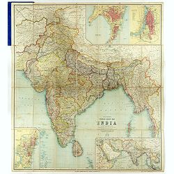
Thacker's Reduced Survey Map of India.
Thacker's reduced Survey Map of India prepared by John Bartholomew and published n Calcutta by Thacker, Spink, & Co. And W. Thacker & Co. in London in 1914.This e...
Date: Calcutta: Thacker, Spink, & Co./ London : W. Thacker and Co., 1914
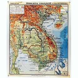
Indochine française. Carte N° 29.
School map of Indochina by Pierre Deffontaines Agréée d'Histoire et de Géographie Docteur es Lettres, published c. 1940 by "Librairie Hatier". Scale : 1:1 60...
Date: Paris, c. 1940
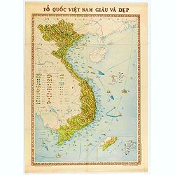
To Quoc Viet Nam Giau Va Dep (Vietnam).
Economic map of Vietnam published in 1976.Features Vietnam, Cambodia, Laos and part of Thailand. With a key referring to agricultural productions and fauna…The map show...
Date: Hanoï, 1976

Arabia Felice Nuova Tavola.
Fine early map of Arabian peninsula, being one of the earliest modern maps of the region.Girolamo Ruscelli first published the map in his "La Geographi di Claudio To...
Date: Venice, 1561

Indiae extra Gangem Pars Septentrionalis. Indiae extra Gangem Pars Meridionalis.
The map on the left depicts the northern portion of the India Ganges region, representing Burma (Myanmar), Thailand, Cambodia, Vietnam and Laos. The right one depicts th...
Date: Utrecht / Amsterdam, J.Halma, 1683
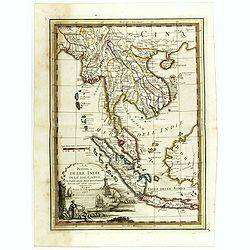
La Penisola delle Indie di la' dal Gange con parte delle Isole della Sonda delineate sulle ultima osservazioni.
First edition on laid paper. Cassini’s splendid early map of Indochina, from Bangladesh in the west to central Borneo in the east, and southern China in the north, to B...
Date: Rome, 1797

Carte de l'Arabie d'après les différents morceaux qu'a donnés M. Niebuh...
Detailed map of the Arabian Peninsula, after Niebuhr, with scales in the lower left corner. Engraved by Pierre-Paul Dubuisson.More about Mapping of Arabia [+]
Date: Paris, ca. 1820

Waere Affbeeldinge Wegens het Casteel ende Stadt BATAVIA Gelegen opt Groot Eylant Java.
A good impression of this finely engraved and detailed plan of Batavia, present-day Jakarta, the Dutch center of trading activities in the East Indies. Copied after Cleme...
Date: Amsterdam, 1721

Itinerarium Sacrae Scripturae. Das ist: Ein Reisebuch...
Itinerarium Sacrae Scripturae. Das ist: Ein Reisebuch, Uber die gantze heilige Schrifft, in zwey Bücher geteilet... Zuvor gemehret mit einem Büchlein De monetis et mens...
Date: Magdeburg, 1587
![View in the island of Cracatoa. [Rakata in the Sunda Strait]](/uploads/cache/30051-250x250.jpg)
View in the island of Cracatoa. [Rakata in the Sunda Strait]
Early view of the volcano Krakatoa (Indonesian name: Krakatau), on the Indonesian island of Rakata in the Sunda Strait, taken from "Views in the South Seas" bei...
Date: London, Boydell and Co., 1808

The Fan palm, in the island of Cracatoa.
The Fan palm, on the island of Krakatoa (Indonesian name: Krakatau), in the Sunda Strait, taken from "Views in the South Seas" being a very important and early ...
Date: London, Boydell and Co., 1808
![XIX. Venatio Elephantum in Pegu. [How elephants are caught in Pegu]](/uploads/cache/29795-250x250.jpg)
XIX. Venatio Elephantum in Pegu. [How elephants are caught in Pegu]
How elephants are caught in Pegu. The king of Pegu had a particular method of transporting elephants. He had a great enclosure built of strong wooden posts, with a trap d...
Date: Frankfurt, 1599

Isole dell'Indie. . .
A beautiful and flamboyantly engraved large-scale map of the East Indies, including the Malay Peninsula, Cambodia, the Philippines and all of Indonesia and the Spice Isla...
Date: Venice, 1696
![[Map of Palestine ]](/uploads/cache/42176-250x250.jpg)
[Map of Palestine ]
Map of Palestine from "La Mer des Hystoires" published by Dupré, Paris, 1536 "La Mer des Hystoires" is a translation into French of the famous "...
Date: Dupre, Paris, 1536
Selling price: ????
Please login to see price!
Sold in 2025
![Province de Fo-Kien. [Includes West Coast of Taiwan]](/uploads/cache/43503-250x250.jpg)
Province de Fo-Kien. [Includes West Coast of Taiwan]
An important map of Fujian Province shows the East Coast of China and the West Coast of Taiwan. It shows that for the Manchu Qing, only the western half of Formosa was co...
Date: The Hague, H. Scheurleer, 1737

Outposts of Empire. Ceylon.
A large colored lithograph by John Vickery (1906-1983), he was an Australian artist. He worked in the fields of painting, illustration and advertising. He is the only Aus...
Date: London, ca 1937
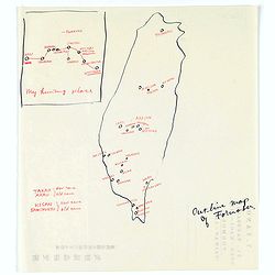
Map of Formosa. My hunting place.
An unusual hand drawn map of Formosa with an inset plan ‘My hunting place’. The map has the major cities marked in red ink and was made during Japanese occupation. Th...
Date: Chiayi, Formosa, ca. 1940

Quella Tavola E l'Antica Siria ch'Era destinta in dodici . . .
Very rare view of Holy Land published in the first edition of "Viaggio da Venetia, a Costantinopoli. Per Mare, e per Terra, & infieme quello di Terra Santa. Da G...
Date: Venice, Giacomo Franco, 1598

A Map and Chart of Arabia, the Red Sea, & Persian Gulf, drawn from the Chart of the Eastern Ocean, Publish'd in 1740, by Order of ye Count de Maruepas,...
A small but unusual map of the Arabian Peninsular, engraved by G. Child for 'The universal traveller: or, A compleat description of the several nations of the world', by ...
Date: London, Th. Salmon, 1752-1753

Waere affbeeldinge wegens het casteel ende stadt Batavia.
A good impression of this finely engraved and detailed plan of Batavia, present-day Jakarta, the Dutch center of trading activities in the East Indies. Copied after Cleme...
Date: Amsterdam, 1681

Der Hollaendisch-Ostindianischen Compagnie Weltberühmte Haupt - Handels und Niederlags stadt BATAVIA..
Very fine decorative plan of Batavia showing the City and its immediate environs, the surrounding rice fields intersected by a network of waterways, canals and outlying f...
Date: Nuremberg, 1733
![Sincapour. [Singapore]](/uploads/cache/23696-250x250.jpg)
Sincapour. [Singapore]
Early view of Singapore after Pâris, engraved in aquatint by Sigismond Himely (1801-1872). The view is drawn looking up the Singapore River from South Boat Quay. It sho...
Date: Paris, Finot, 1835

Pecheli, Xansi, Xantung, Honan, Nanking, In plaga Regni Sinensis. . .
A map of the northern provinces of China after the Jesuit Martino Martini, depicting of Hebei (Pecheli), Shanxi (Xansi), Shandong (Xantung), Henan (Honan), and Jangsu (Na...
Date: Amsterdam, ca 1660

Arabia
A lovely miniature map the Arabian Peninsular, published by Petrus Bertius, and published in Amsterdam at the beginning of the seventeenth century. With an attractive s...
Date: Amsterdam, 1606

La Chine d'Athanase Kirchere de la compagnie de Jesus, illustrée de plusieurs monuments tant sacrés que profanes et de quantité de recherches de la nature. . .
Athanasius Kircher, S.J., (1601 or 1602-1680) was a 17th-century German Jesuit scholar who published around 40 works, most notably in the fields of oriental studies, geol...
Date: Amsterdam, 1670

Carte des Principales Ports de Mer Bancs de sable &c: qui sont dans la Mer Rouge..
Some cities existed along the western coast of the Arabian peninsula, where they served as entrepots for transcontinental trade between Europe and Asia. Mecca, founded by...
Date: Amsterdam, 1720

Nouvel atlas de la Chine, de la Tartarie chinoise, et du Thibet.
First edition of "the principal cartographic authority on China during the 18th century". It was the second major atlas of China produced in Europe following th...
Date: The Hague, H. Scheurleer, 1737
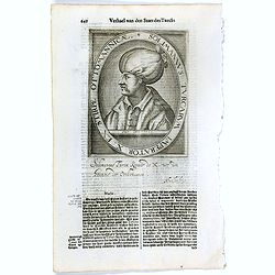
Solimannus Turcarum Imperator X. Ex Stirpe Ottomannicae.
The engraving depicts a half length oval portrait of "Solimannus Turcarum Imperator X", signed lower right corner N. de Cleck". Nicolaes de Clerck (de kler...
Date: Amsterdam, Cloppenburch, 1621

Nouvelle carte des mers comprises entre le détroit de Banca et P°. Timon avec la partie orientale du détroit de Malacca.
Important French chart of the tip of Malaysia with Singapore. Latitude and longitude scales, compass rose and system of rhumb lines, soundings near coast and in bay areas...
Date: Paris, 1745

Philippines Islands.
Pictorial map of Philippines Islands, from the famous illustrator, Ruth Taylor White and published in "Our USA: A Gay Geography".Ruth Taylor White was among the...
Date: Boston, Little, Brown and Company, 1935

Ce que les Anglo-Saxons ont perdu en Extrême-Orient.
Illustrated Vichy propaganda War & Propaganda poster showing a map of South East Asia, with Indonesia, Philippines, Thailand, etc., among photos and explanations abou...
Date: Paris, 1943

Xantung, sinarum imperii provincia quatra.
A map of the northern province ‘Xantung’ of China after the Jesuit Martino Martini.Shows the Great Wall and is centered on the Bohai Sea, and the Shandong and Liaonin...
Date: Amsterdam, ca 1660
Philippines - The famous volcanic peak Mt. Mayon. . .
Mt Mayon Volcano Peak near Legaspi on the Philippines. Fine Pan American Airline mini poster.Pan American World Airways, originally founded as Pan American Airways and co...
Date: 1956
Selling price: ????
Please login to see price!
Sold in 2023

A fan combining views of Hong Kong (right), Canton (center), and Macau.
The fan shows nice images of Macau, Hong Kong and Canton on onside and on verso a garden with 45 characters welcoming a rider on his white horse. Their clothes are height...
Date: China, ca. 1850-1860

Asiae Minoris nova descriptio. Geographische Beschryvinge aller Landen... ende sendbrieuen der Apostele...
Extremely rare map from a Dutch bible, published by Dancker Danckerts. This map was included in a Dutch bible including several maps signed by C.Danckerts and one dated 1...
Date: Amsterdam, 1643
![[Complete set of maps of Japan] Imperium Japonicum Per Regiones Digestum Sex et Sexaginta Atque Ipsorum Japonensium Mappis Descriptum Ab Hadriano Relando.](/uploads/cache/41590-250x250.jpg)
[Complete set of maps of Japan] Imperium Japonicum Per Regiones Digestum Sex et Sexaginta Atque Ipsorum Japonensium Mappis Descriptum Ab Hadriano Relando.
Complete set of 11 maps Reland's map of Japan, the first map to use Sino-Japanese characters on a European printed map and represents a radical departure from prior Europ...
Date: Amsterdam, 1751

Carte d'unne partie de l'Arabie Septentrionale Pour suivre les Voyages de Mr. G.A. Vallin. . .
This is the original hand-drawn map by Victor Adolphe Malte-Brun of "Carte d'unne partie de l'Arabie Septentrionale Pour suivre les Voyages de Mr. G.A. Wallin",...
Date: Paris, November 1855
TYO SYEN Corée par les Missionnaires de Corée de la société des missions etrangéres.
A very nice map and rare map of Korea. Prepared by R.P.Carceri who was an missioner active for de la Sociéte des Missions Etrangères.Published as a supplement to Journa...
Date: Lyon, 1872
Selling price: ????
Please login to see price!
Sold in 2023

Carte des Isles du Japon Esquelles est remarque la Route..
This uncommon map of Japan, on a reasonably large scale, includes comments on the country's nature. For instance, Ocsaqui (Okazaki, near Nagoya) is said to have the most ...
Date: Paris 1679

Arabia. Sive Regio inter Mare Medium, Arabicum Sinum, . . .
Very detailed map of the Arabian Peninsular, covering the Caspian Sea in the upper right corner and Syria to the Indian Ocean, Somalia and parts of Persia, Syria and Kurd...
Date: London, 1841

Arabia.
Steel engraved map of the Arabian Peninsular. It shows Arabia and Parts of Persia, Syria and Kurdistan. The regional boundaries are colored and relief shown by hachures. ...
Date: London, 1841

Asia carta di ciasete piu moderna. (Japan)
Rare FIRST STATE of this important map for Korea and Japan, a map of the Blancus/Moreira type, but adds a huge 'Jesso' filling the top of this old map. The map is of inte...
Date: Florence, 1646-1647

COLLECTION OF HONG KONG MAPS, BOOKS & FLYERS. Including CHINA - HONGKONG surveyed by Captn. Sir Edward Belcher, in H.M.S. Sulphur 1841. Corrected to 1901.
A collection of 30 maps, prints, and publications relating to Hong Kong. Including : - BELCHER, E. Sir, An updated version of this most important nautical chart of Hong K...
Date: London, 1841 - 1901

Sumatra Insula.
A miniature map of Sumatra and the Malay Peninsula, including Singapore and the various islands directly south of it. Containing detailed geography and nomenclature aroun...
Date: Amsterdam, 1609
![[Arabia]](/uploads/cache/40143-250x250.jpg)
[Arabia]
A lovely miniature map of the region of Armenia and Georgia, showing both parts of the Black Sea and Caspian Sea. For such a small map, it renders a wealth of detail, wit...
Date: Ulm, 1692

India Tercera Nuova Tavola.
The 1598 edition of this early map of South East Asia. Just to the west and south of Malacca one will notice ‘Camatra’ (Sumatra) and Java. China with Canton in the up...
Date: Venice, 1598

Iava Maior.
Very fine miniature map of Java, engraved by Benjamin Wright (1575-1613). This early map contains detailed geography and nomenclature around the northern coastline of the...
Date: Amsterdam, Cornelis Claes, 1606

The Kingdome of China.
A most sought-after map of China. Decorative border vignettes including views of the cities of Quinzay and Macao along the top border with the wheeled wind machines and p...
Date: London, G. Humble, 1627

China Veteribus Sinarum Regio.
Based on Jesuit surveys, the map represents the next major revision in the cartography of China after Ortelius' 1584 map. Korea, however, is still an island, and Japan co...
Date: Amsterdam, 1640

Mocha, in Arabien. (View of Mocha, Yemen.)
Magnificent bird's eye-town-view of Mocha in Yemen.. Etched by Gaspar Bouttats (1640-1695).The Antwerp based publisher Jacques Peeters published ca. 1690 a series of prin...
Date: Antwerp, c.1690

Tabula nova utriusque Indiae.
This is the fourth and last edition of this map based on Waldseemüller's first "modern" map of Asia. It follows that cartography without change but adds an int...
Date: Vienne, 1541

Tabula Superioris Indiae & Tartariae maioris. (Modern Map of China, Japan, etc.)
Important map extending from Tartary in the north, to "Prov. Bocat" (Cambodia) in the south. "Tebet" is shown prominently, as is "Zinpangri"...
Date: Vienne, 1541

Arabia.
A handsome map of the Arabian Peninsula drawn on a large scale on which the three classical divisions are shown with some urban centers and topographical features. A cert...
Date: Amsterdam, 1662

Asia.
Uncommon map of Asia. Engraved by Marco di Pietro.The map is of interest for the use of G. di Corea, for the sea between Korea and Japan.Published by Carlo Antonio Barbie...
Date: Milan, 1807