Browse Listings
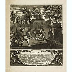
Travail des mains. 11
Print showing the manual labor of the religious of the abbey of Trappe. From a series of 19 prints, "Les travaux et les jours de la Trappe", illustrates the lif...
Date: Paris, ca. 1700
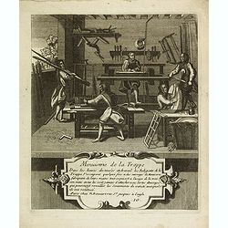
Menuiserie de la Trappe. 10
Print showing the carpentry of Trappe. From a series of 19 prints, "Les travaux et les jours de la Trappe", illustrates the life of the Trappists, their manual ...
Date: Paris, ca. 1700
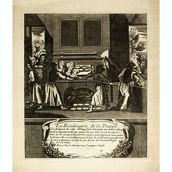
La boulangerie de la Trappe. 9
Print showing the bakery in Trappe. From a series of 19 prints, "Les travaux et les jours de la Trappe", illustrates the life of the Trappists, their manual act...
Date: Paris, ca. 1700
![[Title page] Libellus Novus Politicus.. Pars Quinta.](/uploads/cache/38475-250x250.jpg)
[Title page] Libellus Novus Politicus.. Pars Quinta.
Very skilfully engraved title page from a rare work printed by Eberhard Kieser: Thesaurus Philo-Politicus. Das ist Politisches Schatzkästlein guter Herren und bestendige...
- $80 / ≈ €69
Date: Frankfurt, 1700
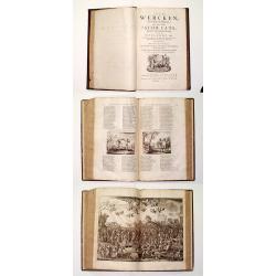
Alle De Wercken, soo Oude als Nieuwe van den Heer Jacob Cats, Ridder, oudt Raadtpensionaris Van Hollandt, &c. : Op nieus vermeerdert met des Autheurs Tachtig-jarig Leven, Huyshoudinge en Bedenckingen op Zorg-vliet.
A very good example of the collected works of the most celebrated Dutch author of the seventeenth century. Illustrated with over 400 engravings after van de Venne by Hond...
- $1900 / ≈ €1644
Date: Amsterdam, 1700
![[Drawing of a Tulip]](/uploads/cache/06621-250x250.jpg)
[Drawing of a Tulip]
Very detailed and well-executed tulip drawing by an unknown artist attributed to the School of Anthony Claesz (1607/8-1649)This drawing was made for a 'Tulip book' painte...
- $1500 / ≈ €1298
Date: The Netherlands c.1700
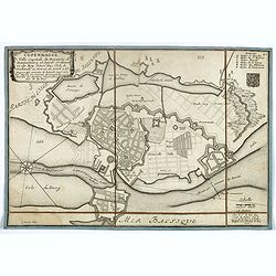
Copenhague ville capitale du royaume de Dannemarq et séjour ordinaire du Roy . . .
Separately published town-plan of Copenhagen, also published in de Fer's "Curious Atlas". Engraved by C.Inselin. Plan is dated 1700 in lower right corner. With ...
- $150 / ≈ €130
Date: Paris, 1700

Collection of rubbings with portraits and biographies of famous Chinese philosophers, poets and legendary wise old men.
Collection of portraits and biographies of famous Chinese philosophers, poets, and legendary wise older men. All portraits and text are original rubbings from stone table...
- $15000 / ≈ €12982
Date: China or Korea, c. 1701
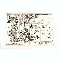
Nova Et Vera Exhibitio Gerographica Insularum Marianarum . . .
Attractive map of the Philippines, Japan, Korea and Indonesia with an inset of the island Guam, by the Jesuit Heinrich Scherer, printed in for Scherer's 'Atlas Novus'. Se...
- $1200 / ≈ €1039
Date: Munich, c.1702

Insula S. Laurentii.
Miniature map of Madagascar, with four inset maps. From the French reissue of the account of early Dutch voyages first published in 1608 by Commelin. The French translati...
Date: Amsterdam, E. Roger, 1702
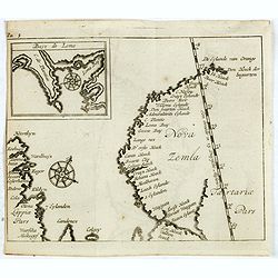
(Map of Nova Zembla with inset of Baye de Loms.)
Map of Nova Zembla with inset of Baye de Loms (5x7mm.). From the French reissue of the account of early Dutch voyages first published in 1608 by Commelin. The French tran...
- $110 / ≈ €95
Date: Amsterdam, E. Roger, 1702
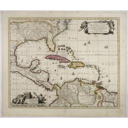
Insulae Americanae in Oceano Septentrionali..
A particularly handsome map portraying the south-eastern U.S., the Caribbean islands, part of Mexico, Central America, Florida (called tegesta Prov. ) and part of South A...
- $1500 / ≈ €1298
Date: Amsterdam, 1702
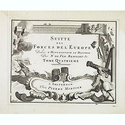
(Title page) Suite des Forces del'Europe. . .
Very decorative title page from the Amsterdam edition of ca. 1702 by Pieter Mortier (1661-1711) of de Fer's important work "Les forces de l' Europe."This plate ...
- $150 / ≈ €130
Date: Amsterdam, c.1702
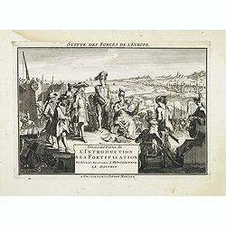
(Title page) Troisieme Partie de L'Introduction a la Fortification. . .
Very decorative title page from the Amsterdam edition of ca. 1702 by Pieter Mortier (1661-1711) of de Fer's important work "Les forces de l' Europe."This plate ...
- $225 / ≈ €195
Date: Amsterdam, c.1702
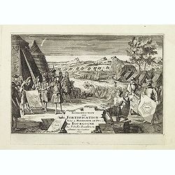
(Title page) Introduction a la Fortification. . .
Very decorative title page from the Amsterdam edition of ca. 1702 by Pieter Mortier (1661-1711) of de Fer's important work "Les forces de l' Europe."This plate ...
- $150 / ≈ €130
Date: Amsterdam, c.1702
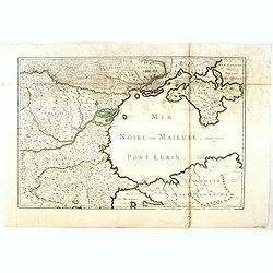
(Mer Noire ou Maieure, Pont Euxin.)
Very rare and detailed map of the Black Sea area prepared by Placide de Sainte-Hélène (1648-1734). and engraved by Claude-Auguste Berey (1651-1732).The map is of partic...
- $350 / ≈ €303
Date: Paris, 1703
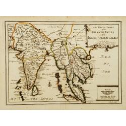
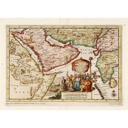
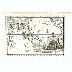
Les Vrays Indes dits Grands Indes ou Indes Orientales Par N. de Fer. Geographe de Sa Majeste Catoliques et de Monseigneur le Dauphin.
Detailed map on India, Thailand, the Malay Peninsular and the south coast of China up to Macao. The map was engraved by C. Inselin.
Date: Paris, 1703
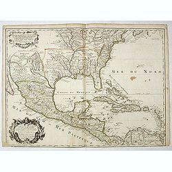
Carte du Mexique et de la Floride des Terres Angloises et des Isles Antilles...
The scarce third state with the imprint : "Chez l’Auteur sur le Quai de l’Horloge a la Cour.r de Diamãs. Avec Privilege du Roy po.r 20 ans, 1703". By 1707 ...
Date: Paris, 1703
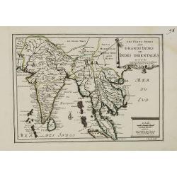
Les Vrays Indes dits Grands Indes ou Indes Orientales Par N. de Fer. Geographe de Sa Majeste Catoliques et de Monseigneur le Dauphin.
Detailed map on India, Thailand, the Malay Peninsular and the south coast of China up to Macao. The map was engraved by C. Inselin.
- $500 / ≈ €433
Date: Paris, 1703
![[No title] Germany and Poland.](/uploads/cache/37522-250x250.jpg)
[No title] Germany and Poland.
A untitled miniature map od Gemany and Poland by the German cartographer Johann Ulrich Müller. The map shows the regions of present-day Poland and Germany.For such a sma...
- $180 / ≈ €156
Date: Ulm, c 1703
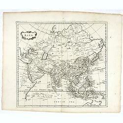
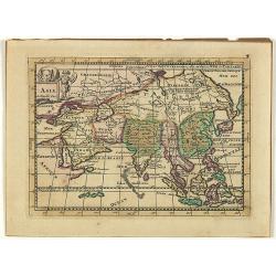
Asia.
Map of Asia. Peter Heylin or Heylyn (29 November 1599 – 8 May 1662) was an English ecclesiastic and author of many polemical, historical, political and theological trac...
- $450 / ≈ €389
Date: London, 1703
![[Breisach] Profil de la ville de Brisac scituée sur le Rhin dans le Brisgau prise par l'armée du Roy commandée par Monseign.r le duc de Bourgogne le 6.e septembre 1703.](/uploads/cache/43496-250x250.jpg)
[Breisach] Profil de la ville de Brisac scituée sur le Rhin dans le Brisgau prise par l'armée du Roy commandée par Monseign.r le duc de Bourgogne le 6.e septembre 1703.
Scene of the siege of Breisach in 1703 by Marshal Tallard during the Spanish Succession War.
- $120 / ≈ €104
Date: Paris, 1703
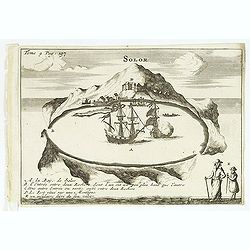
Solor / A la Baye de Solor.
Decorative map of the Bay of Solor. With a lettered key (A - E). Solor is a volcanic island located off the eastern tip of Flores island in the Lesser Sunda Islands of In...
- $120 / ≈ €104
Date: Amsterdam, E. Rogers, 1703
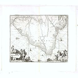
Brasilia.
Very fine decorative map od Brazil with west to the top. From the book "A Collection of Voyages and Travels" by Churchill and the map came from the part contain...
- $550 / ≈ €476
Date: London, Printed for A. and J. Churchill, 1703
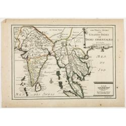
Les Vrays Indes dits Grandes Indes ou Indes Orientales Par N. de Fer. Geographe de Sa Majeste Catoliques et de Monseigneur le Dauphin.
Detailed map on India, Thailand, the Malay Peninsular and the south coast of China up to Macao. The map was engraved by C. Inselin.
Date: Paris, 1703
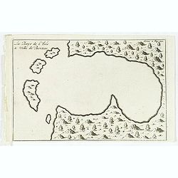
La Baye de l'Isle & ville de Borneo.
Uncommon map of a Bay on the island of Borneo. From the French reissue of the account of early Dutch voyages first published in 1608 by Commelin. The French translation w...
- $100 / ≈ €87
Date: Amsterdam, E. Roger, 1703
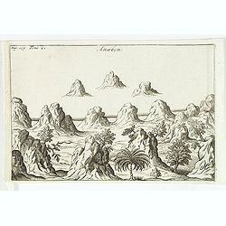
Anabon. (Ambon)
A fanciful view of a landscape on the island Ambon. From the French reissue of the account of early Dutch voyages first published in 1608 by Commelin. The French transla...
- $120 / ≈ €104
Date: Amsterdam, E. Rogers, 1703
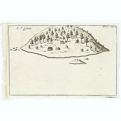
I. S. Clara.
Island "S. Clara" in Brazil just a few degrees north of the Tropic of Capricorn. From volume two of the French reissue of the account of early Dutch voyages. T...
- $150 / ≈ €130
Date: Amsterdam, E. Roger, 1703
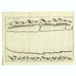
I. S. Sebastien.
Simplified bird's-eye view of Ilha de São Sebastiao, part of an archipelago off the southern coast of Brazil 210 miles from Rio de Janeiro. It was discovered on January ...
- $225 / ≈ €195
Date: Amsterdam, E. Roger, 1703
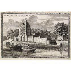
Generaliteits Kruyt-Magasyn.
The print depicts the gunpowder storage in Rotterdam. A most decorative item.
- $50 / ≈ €43
Date: Amsterdam, 1703

II Regno di Francia Diviso in Provincie e Governi ove su`Le Frontiere di esso Rappresenta il Teatro della Guerre di Flandria Germania Savoja e Lombardia.
Very rare wall map of France depicting "The Kingdom of France divided into Provinces and Governments with on its borders the Theater of War of Flanders, Germany, Sav...
Date: Naples, 1704
L'Allemagne divisée en dix cercles . . .
An interesting small map of Germany and Poland by Nicolas de Fer. From his rare "Petit et Nouveau Atlas". The first edition was published in 1697 and was republ...
Date: Paris, 1704
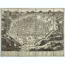
Plaisance ou Piacensa, ville de la Lombardie, capitale du duché de Plaisance.
Rare and beautiful bird's-eye plan of the town of Plaisance in Lombardy, accompanied by 120 key to the most important points in town. Second state with " XIX" i...
- $400 / ≈ €346
Date: Amsterdam, 1704
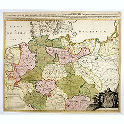
Regni Borussiae et Electoratus Brandenburgici, Ceterarum que, Quae Fridirici Reg. Bor. sceptro reguntur nec non finitimarum Prov. Delineatio. . .
Rare post-route map covering Germany, Poland, the Low Countries, and Czechoslovakia. The map gives in detail the German postal routes and postal stations. Within the lowe...
- $750 / ≈ €649
Date: Amsterdam, 1704

Nieuwe gelyk Graadige Paskaart van de Kust van Guiana in West-Indien.
Detailed chart of Guiana in South America. Two scales are given in both maps: Dutch, French and English nautical miles.The inset chart provide detailed view of the Camopi...
- $650 / ≈ €563
Date: Amsterdam, 1684 - 1704
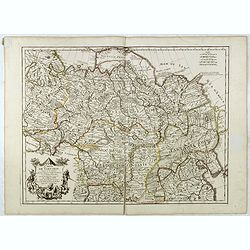
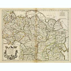
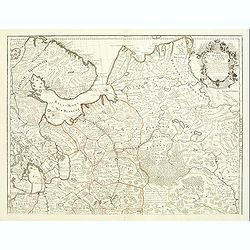
Estats du Grand Duc de Moscovie.
Lovely small map of' Russia in Europe', extending from Poland and the Baltic in the west, Zembla in the frozen north, reaching down south to the Ukraine with Kiev and par...
- $150 / ≈ €130
Date: Paris, 1705
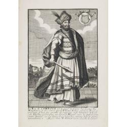
Le Roy de Camboia est le Seig.r de touts les Costes de Malabares, et des terres que le Fleuve Indus. . .
Very rare and decorative costume plate. Underneath the plate a descriptive text in French.Bears the address : A Paris chez F. Jollain l aine Rue St Jacques a la Ville de ...
- $200 / ≈ €173
Date: Paris, ca. 1685-1705
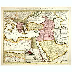
Imperium Turcicum Complectens Europae, Asiae, et Africae, Arabiae que Regiones ac Provincias Plurimas Industria et Labore . . .
Petrus Schenk's map of the Ottoman Empire, is based upon an earlier map by Sanson. It is showing from Italy to the Caspian Sea and the Saudi Peninsula, centered on Cyprus...
- $1000 / ≈ €865
Date: Amsterdam, circa 1705
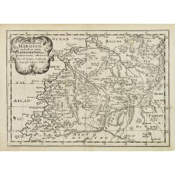
'T Koninkryk van Marocco, verdeelt in Zeven Landschappen, enz. . .
A Dutch edition of this finely engraved map of Morocco filled with mountain ranges, oases and cities. The map is adorned with a decorative cartouche.
- $90 / ≈ €78
Date: Amsterdam, ca. 1705
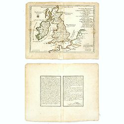
Les Isles Britanniques ou sont les Royaumes . . .
An interesting small map of the British islands by Nicolas de Fer. From his rare "Petit et Nouveau Atlas". The first edition was published in 1697 and was repub...
Date: Paris, 1705
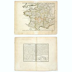
La France avec ses acquisitions jusqu'à l'année 1705.
An interesting small map of France by Nicolas de Fer. From his rare "Petit et Nouveau Atlas". The first edition was published in 1697 and was republished in 170...
Date: Paris, 1705
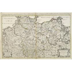
Le cercle de la Basse Saxe subdivisé en touts les estats et principautés qui le composant . . .
It is a very large map centered on the river Elbe and following the coastlines of the Baltic Sea up to the Polish border. The map is fully and richly engraved. Large and ...
- $200 / ≈ €173
Date: Amsterdam, c.1705
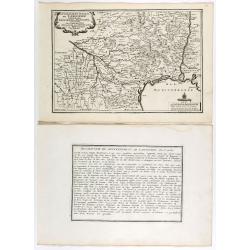
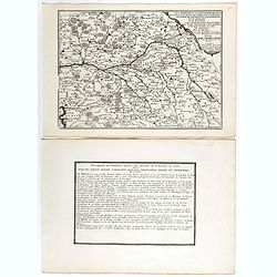
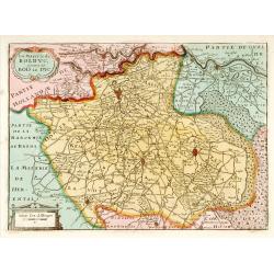
Gouvernement general de Languedoc . . .
Map of the Languedoc region, from Nicolas de Fer's "L'Atlas curieux ou le Monde réprésente dans des cartes. "The "Atlas Curieux" is a geographic enc...
Date: Paris, 1705
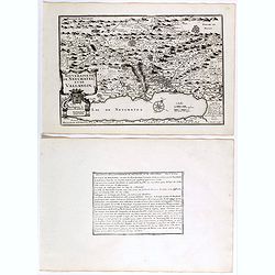
Souveraineté de Neuchatel et de Vallangin.
Map of the Neuchatel region, from Nicolas de Fer's "L'Atlas curieux ou le Monde réprésente dans des cartes. "The "Atlas Curieux" is a geographic enc...
Date: Paris, 1705
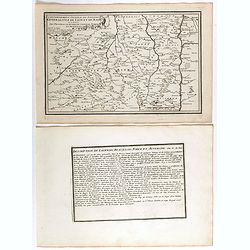
Les Provinces, ou Gouvernement de Poictou, d'Anjou, du Maine, De Touraine . . .
Map centered on Loire region, with Blois, Saumur, Sancerre and Orleans, from Nicolas de Fer's "L'Atlas curieux ou le Monde réprésente dans des cartes. "The &q...
Date: Paris, 1705
Gouvernement general du Lionnois, generalitez de Lion et de Riom . . .
Map of central France with Clermont-Ferrand and Lyon to the right, from Nicolas de Fer's "L'Atlas curieux ou le Monde réprésente dans des cartes. "The "A...
Date: Paris, 1705
Gouvernement de Dauphiné, Generalité de Grenoble.
Map of the Dauphiné region, from Nicolas de Fer's "L'Atlas curieux ou le Monde réprésente dans des cartes. "The "Atlas Curieux" is a geographic enc...
Date: Paris, 1705
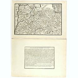
Gouvernement general de Picardie . . .
Map of the Picardie region, from Nicolas de Fer's "L'Atlas curieux ou le Monde réprésente dans des cartes. "The "Atlas Curieux" is a geographic ency...
Date: Paris, 1705
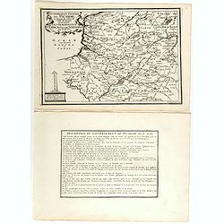
Les Gouvernements generaux de l'Isle de France et de Champagne, ou se trouvent les generalitez de Paris et Chaalons.
Map of the Isle de France and Champagne regions, from Nicolas de Fer's "L'Atlas curieux ou le Monde réprésente dans des cartes. "The "Atlas Curieux"...
Date: Paris, 1705
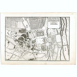
Plan general des chateaux et ville de St Germain en Laye.
City plan of St Germain en Laye, from Nicolas de Fer's "L'Atlas curieux ou le Monde réprésente dans des cartes. "The "Atlas Curieux" is a geographic...
Date: Paris, 1705
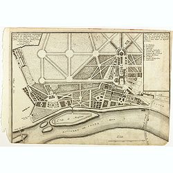
Plan de la belle et magnifique Maison de Monsieur A St Cloud . . .
Plan of the city of Saint Cloud, from Nicolas de Fer's "L'Atlas curieux ou le Monde réprésente dans des cartes. "The "Atlas Curieux" is a geographic...
Date: Paris, 1705
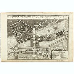
Plan general de Chantilly . . .
Plan of the city of Chantilly, from Nicolas de Fer's "L'Atlas curieux ou le Monde réprésente dans des cartes. "The "Atlas Curieux" is a geographic e...
Date: Paris, 1705
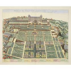
Hortus et Palatium Atestinorum Tyburi.
Showing in great detail the hortus and gardens of Villa Tivoli.Joan Blaeu published during his life three town-books of Italy: Citta del Vaticano, Roma and Napoli. By the...
Date: Amsterdam, 1705
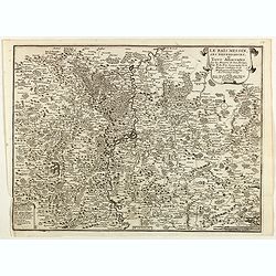
Le Païs Messin, ses dependances, et Terre Adiacentes.
Map of the Messin region, from Nicolas de Fer's "L'Atlas curieux ou le Monde réprésente dans des cartes. "The "Atlas Curieux" is a geographic encycl...
Date: Paris, 1705

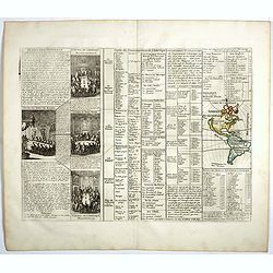
Le nouveau plan de Paris dressé sur les Mémoires de M. Jouvin de Rochefort…
Published "In Paris, at the home of the Lord of Iron. On the Isle of the Palace on the Quay of the Clock at the Royal Sphere. With Privilege of the King 1705". ...
- $7500 / ≈ €6491
Date: Paris, de Fer, 1705
Algemeene Wereldtbeschryving . . .
Decorative allegorical title page.
- $80 / ≈ €69
Date: Amsterdam, 1705
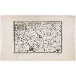
![Le Cours du Danube. . .[2 maps].](/uploads/cache/28472-250x250.jpg)
Le Cours du Danube. . .[2 maps].
Detailed two-sheet map of the course of the River Danube from its source up to Vienna. Showing the cities, like Linz, Passau, Straubing, Regensburg, Ulm, Augsburg, Munich...
- $450 / ≈ €389
Date: Paris, 1705

Description de l'Isle Formosa en Asie, du gouvernement, des
Complete title: Description de l'Isle Formosa en Asie, du gouvernement, des Moers & de la religion des habitans.Rare first French edition of one of the most famous fi...
Date: Amsterdam, 1705
Carte du gouvernement de l'Amerique.
A double page sheet including a fine map of America, with California with indented northern coastline (130x92mm.) and New Mexico extending across most of western North Am...
- $300 / ≈ €260
Date: Amsterdam, 1705
Carte du gouvernement de l'Amerique.
A double page sheet including a fine map of America, with California with indented northern coastline (130x92mm.) and New Mexico extending across most of western North Am...
- $300 / ≈ €260
Date: Amsterdam, 1705
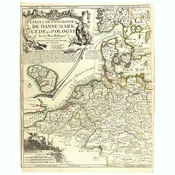
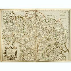
Estats..de Dannemark, Suede, et Pologne..
Rare map of Poland, Denmark, Sweden, The Netherlands, Belgium and Germany. Engraved by H.van Loon. Upper left hand corner fine title cartouche and inset map of the island...
- $400 / ≈ €346
Date: Paris, 1705
![[Title page] L'Atlas curieux ou le Monde réprésente dans des cartes. . .](/uploads/cache/31054-250x250.jpg)
[Title page] L'Atlas curieux ou le Monde réprésente dans des cartes. . .
Engraved title page from Nicolas de Fer's "Atlas Curieux". Text heightened with gold and silver, now oxidized. In lower part figures symbolizing mapmaking and a...
- $100 / ≈ €87
Date: Paris, 1705
Reys-togt Thomas Coryat van Jerusalem te Land gedaan na Asmere de Hof-Stadt des Grooten Mogols in Oostindien.
The regional map illustrates the narrative of Thomas Coryat's travels by land from Jerusalem to the Court of the Great Mogul. Coryat travelled to Ajmer in India to the co...
- $450 / ≈ €389
Date: Leiden, 1706
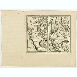
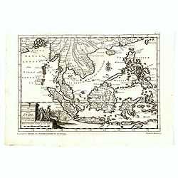
Prequ Isle de L'Inde deca Le Golfe du Gange (and) Prequ Isle de l'Inde dela le Golfe du Gange.
A very rare double map of India, Sri Lanka and the Maldives islands, together with a separate map of Cambodia, Thailand, Malaysia and North Sumatra. The map shows Bangkok...
- $150 / ≈ €130
Date: Brussels, Antwerp, 1706
Carte de Tartarie.
Covering north east Asia, Tibet, Korea and part of "Terre d'Eso". Nova Zembla joined with the mainland.With good detail in Korea, several cities a labeled: Ch...
- $300 / ≈ €260
Date: Paris, 1706
Asia.
Uncommon map of Asia, with a curious shape for Korea. Nice title cartouche in upper left corner with an elephant and a warrior. From his atlas Oorlogs tablessen, Oft uytg...
- $300 / ≈ €260
Date: Amsterdam, 1706
Carte de Tartarie..
Uncommon Amsterdam edition covering north east Asia, Korea and part of "Terre d'Eso". Nova Zembla joined with the mainland. Showing the Caspian Sea with presen...
Date: Amsterdam, 1706
Carte de Tartarie.
Rare first edition "Chez l'Auteur Rue des Canettes préz de St. Sulpice". The "Rue des Canettes" address appears on the original versions of maps date...
- $600 / ≈ €519
Date: Paris, 1706
Carte de Moscovie dresseé par G.De L'Isle. . .
Detailed map of Russia centered on Moscow, including Lapland, prepared by de L'Isle and published in Amsterdam. With fine uncolored title cartouche.
- $375 / ≈ €325
Date: Paris, 1706
Zee-Togt van den Grooten Turk Uyt het Roode Meyr Tegen de Portugy fen na Indien tot aan Kaap Comorin Ondernomen.
Map of the Arabian peninsula, with Saudi Arabia, the Indian Ocean and India and Ceylon.Although not renowned for the originality of his work, Pieter van der Aa is highly ...
- $450 / ≈ €389
Date: Leiden, 1706
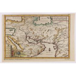
La Mayerie de BOLDVC,. . .
From his atlas Oorlogs tablessen, Oft uytgesochte Kaarten . Covering the so-called area Meierij van 's-Hertogenbosch . Eindhoven in the centre of the map.
Date: Amsterdam, 1706
De Land-Reyse, door Benedictus Goes, van Lahor gedaan, door Tartaryen na China.
Interesting map showing the region of northeastern India, Nepal, Bhutan, Assam and Bangladesh. Canton in lower right corner.The map illustrates the narrative of the trave...
- $200 / ≈ €173
Date: Leiden, 1707
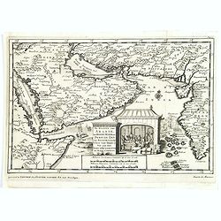
Indien onder den Heer Lopo Vaz De Sampayo, als Gouverneur Generaal tot aan Nieuw-Spanje in American on Kusten van Peru en Chili bevaaren.
Most decorative and scarce item, centred on Indonesia, including an incomplete coast of Australia, and west coast of America. The South Pacific is occupied by a large tit...
Date: Leiden, 1707
D'Indize kusten van Bengale, Pegu, Malacca en Siam Tot in China. . .
Map of Indonesia, Malacca with Singapore (Cingapura) and Taiwan in upper right corner. In lower left a fine title cartouche showing Duarte de Menezes.Although not renowne...
Date: Leiden, 1707
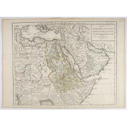
Carte de L'Egypte de la Nubiede L'Abissinie. . .
Including the Arabian Peninsula. Giving good detail on Egypt. Engraved by Desrosiers.More about Mapping of Arabia [+]
- $300 / ≈ €260
Date: Paris, 1707
Partie Méridionale de l'Archevesché et Eslectorat de Cologne. . .
Fine map of the Westphalia, the area in-between the Rivers Maas and Rhine.
- $50 / ≈ €43
Date: Paris, 1707
De kusten van Arabie het Roode Meer en Persize Zee..
Map of the Arabian Peninsula till West Coast of India, southern Persia and the 'Horn of Africa'. Although not renowned for the originality of his work, Pieter van der Aa ...
- $350 / ≈ €303
Date: Leiden, 1707
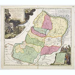
IUDAEA seu PALAESTINA... TERRA SANCTA... IUDA et ISRAEL
Map of Palestine divided among the Tribes, drawn by Homann after Guillaume Sanson. The shoreline runs from Sidon as far as Rinocorura. The Kishon River is shown as connec...
- $500 / ≈ €433
Date: Nuremberg, 1707
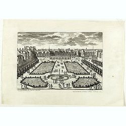
Le Parterre du Palais Royal.
View of the Palais Royal published by I. Mariette. Etched by Gabriel Pérelle (1603-1677) and included in "Veues des plus beaux bastimens de France". Plates for...
- $200 / ≈ €173
Date: Paris, 1700 - 1707
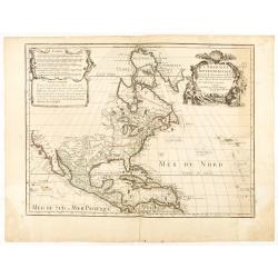
L'AMERIQUE SEPTENTRIONALE Dressée sur les Observations de Mr
One of the most influential maps of North America, laying the groundwork for much of the cartography of the 18th century. This is an early re-issue of De l'Isle's landmar...
Date: Paris, 1700 -1708