Browse Listings in Map Types > Pictorial & Advertising
(Design for Hark ! Hark ! The dogs do bark.)
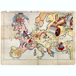
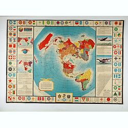
This very rare political caricature map of Europe depicts the continent at the outbreak of World War I, or as it was called at the time the Great War. The principal count...
- $3000 / ≈ €2544
Date: London, ca. 1914
![[2 maps] Das Europa der Zukunft... / Das heutige Europa…[The Europe of the Future / The Europe of Today]](/uploads/cache/48735-250x250.jpg)
[2 maps] Das Europa der Zukunft... / Das heutige Europa…[The Europe of the Future / The Europe of Today]
A pair of very scarce WWI German maps highlighting Europe as it currently was, and Europe as it may become. The maps were produced as part of an 8 page booklet produced b...
- $2750 / ≈ €2332
Date: Paris, 1917

The Wonderground Map of London.
A large and pictorially striking 'Wonderland' advertising poster on behalf of the London Underground, published in the late 1920s. The poster was very popular, and ran fo...
Date: London, 1927
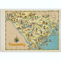
South Carolina.
A fun, humorous, whimsical map of South Carolina by Ruth Taylor White. With vibrant colors.The state is filled with delightful cartoonish characters, some pursuing assort...
- $125 / ≈ €106
Date: Boston, ca 1935
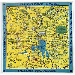
The Famous Hysterical Map of Yellowstone Park, including a few minor Changes.
A lovely whimsical map of America's Yellowstone Park, published about the time of President Franklin Roosevelt's "New Deal" for America in 1936. To emphasise th...
Date: America, ca 1936
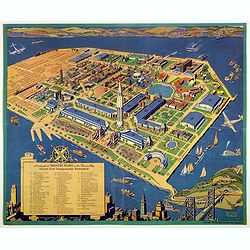
A cartograph of Treasure Island in San Francisco Bay Golden Gate International Exposition.
Ruth Taylor White's large format map of Treasure Island and the San Francisco Golden Gate Exposition Fairgrounds, published in 1940.The map provides an aerial panorama of...
- $200 / ≈ €170
Date: San Francisco, 1940
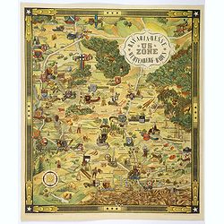
US ZONE. Bavaria, Hesse, Wurtemberg, Baden.
An unusual decorative pictorial map, from the years immediately following World War II, depicting the American Zone of Occupation in southern Germany. It portrays rural ...
- $450 / ≈ €382
Date: Munich, 1940
![[Mussolini Celebrates Pearl Harbor] Grande Carta Del Pacifico](/uploads/cache/48536-250x250.jpg)
[Mussolini Celebrates Pearl Harbor] Grande Carta Del Pacifico
A world map issued four days after the Japanese attack on Pearl Harbor, which led England and the United States to declare war on Japan, this message from Mussolini, cele...
- $500 / ≈ €424
Date: Rome / Milan, 1941
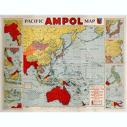
Pacific AMPOL Map
A large and very colorful World War II era map of the Pacific Ocean produced with the complements of the Australian Motorists Petrol Co. Ltd. The map itself shows the Pac...
- $1000 / ≈ €848
Date: Australia, ca 1942
Freedom of the Air.
A world map packed with information about aviation and the aluminum industry.The use of aircraft in warfare, especially in the roles of close ground support and strategic...
- $230 / ≈ €195
Date: United-States, 1943
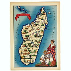
Madagascar.
Very decorative, informative map of Madagascar. The map is filled with buildings, animals, figures and two locals in their typical dress.In lower left corner "Imprim...
- $90 / ≈ €76
Date: France, 1943
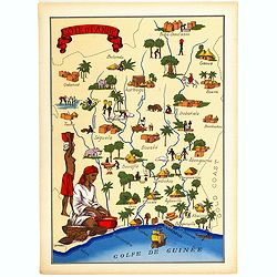
Cote d'Ivoire.
Very decorative, informative map of the Ivory coast. The map is filled with buildings, animals, a ship, figures and two locals in their typical dress.In lower left corner...
- $90 / ≈ €76
Date: France, 1943
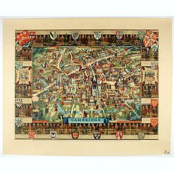
Cambridge.
Though the city had endured significant damage during the Second World War, which ended only a few years prior to publication, there is little indication of the destructi...
- $550 / ≈ €466
Date: London, 1948
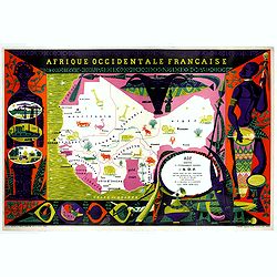
Afrique Occidentale Française AOF.
Beautiful and decorative lithograph pictorial map of Equatorial Africa, showing animals in a beautiful design… Made for Agence de la France d'Outre-Mer. The artist Alai...
- $1100 / ≈ €933
Date: Imprimerie Raidot, Paris, ca. 1950
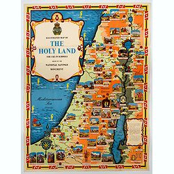
Ilustrated Map of The Holy Land for use in schools…
A visually striking and impressive pictorial map of The Holy Land, as issued by the National Savings Movement / Committee during the 1950s. In the upper left quadrant of...
- $250 / ≈ €212
Date: London, ca. 1950
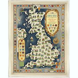
National saving map og the British Isles . . .
A brilliantly eccentric poster showing the festivals, customs of the British Isles with the arms and seals of the counties.Founded in 1861, National Savings is a state-ow...
- $450 / ≈ €382
Date: London, 1951
![[ Pictorial world map ]](/uploads/cache/44376-250x250.jpg)
[ Pictorial world map ]
Pictorial world map includes decorative title cartouche and compass rose. Drawn by Jacques Liozu, a French illustrator who drew a number of maps in this style in 1951, in...
Date: Paris, 1951
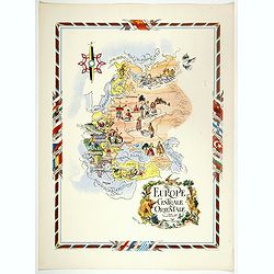
L'Europe Centrale et Orientale.
Pictorial tourism poster of central and eastern Europe, showing different life scenes relative to the culture's country.Learn more about pictorial maps. [+]
- $100 / ≈ €85
Date: Paris, 1951
![[In Arabic, translates : A map of the United States of America shows its major regional ressources and its natural products]](/uploads/cache/43010-250x250.jpg)
[In Arabic, translates : A map of the United States of America shows its major regional ressources and its natural products]
Chromolithographed pictorial poster of the United States in Arabic. Showing the United States' main products, regional resources and physical features. The map is covered...
Date: Washington D.C., ca. 1965
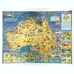
Australia, The Awakening Giant.
This large, fully colored map of Australia was published in America and Australia in the late 1960s. The map is covered in small colored illustrations, connected with loc...
Date: Victoria, 1967
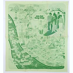
Beatles Map.
A lovely example of the scarce 'Beatles Map' of Liverpool, published in 1974 to commemorate the buildings and places where the Beatles started their stellar careers. The ...
Date: Liverpool, 1974
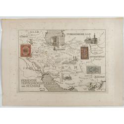
Persische Teppichknüpfgebiete und Stämme.
Map of Iran and neighboring countries in German language, published in limited edition probably in France : "Gravée à l'eau-forte et au burin. Edition limitée&quo...
Date: France ?, after 1935 - before 1991

