Browse Listings in Map Types

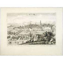
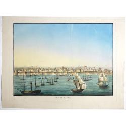
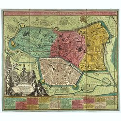
Vue et perspective de la ville de Marseille et ses environs, prise du côté de la belle vue de la plaine St. Michel. Dediée à S. A. S. Mgr. le duc de Penthievre Grand Amiral de France. Par son très humble et très obéissant Serviteur Aulagnier.
Scarce large and spectacular panorama of the city and harbour of Marseille published in Paris in the middle of the 18th century. Engraved by Pierre Jacques Duret under th...
- $12000 / ≈ €11229
Place & Date: Paris, 1751

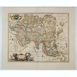
Carte d'Asie divisée en ses principaux Etats.
Uncommon and decorative "carte à figures" wall map, prepared by Clouet, with superb decoration including a wonderful rococo border with vignettes describing hi...
Place & Date: Paris, Mondhare, 1787
![[East coast of Africa, Arabia and west coast of India.]](/uploads/cache/04762-250x250.jpg)
[East coast of Africa, Arabia and west coast of India.]
Rare. Map of the east coast of Africa, Including Madagascar, the Arabian Peninsular, coast of Pakistan and west coast of India.Prepared by Joao Teixeira in 1649, this cha...
Place & Date: Paris, 1664-1696

L'Amérique divisée en ses principaux Etats Dressée d'après les Cartes de Mr. Bonne?
Rare, wall map of America in 2 sheets, after R. Bonne. With 3 inset maps of Hispaniola, Martinique and Hudson Bay. Beautiful title cartouche depicting a Native American l...
Place & Date: Paris, 1788
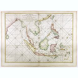
Carte réduite de l'archipel des Indes orientales avec les côtes du continent depuis le golfe de Manar jusqu'à Emoui à la Chine . . .
Important French chart of South East Asia with very good detail on Philippines. Latitude and longitude scales, compass rose and system of rhumb lines, soundings near coas...
Place & Date: Paris, 1745
Selling price: $3000
Sold in 2017

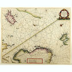
Pascaarte van een deel der Oost Zee, tusschen Bornholm ende der Memel, vertonende de ware gelegentheijt der Zeecusten van Pruijssen. . .
This very rare chart of the Northern Coast of Poland with Gdansk, appeared in the rare English edition of Willem Blaeu's 'Het Licht der Zeevaert', an atlas of sea charts ...
- $4000 / ≈ €3743
Place & Date: Amsterdam, 1608
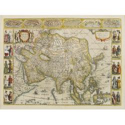
Asia recens summa cura delineata.
This is the rare early issue with decorative paneled borders. In upper border views and plans of Famagusta, Rhodos, Damascus, Jerusalem, Aden and Ormus. Originally engrav...
Place & Date: Amsterdam, 1632

The Wonderground Map of London.
A large and pictorially striking 'Wonderland' advertising poster on behalf of the London Underground, published in the late 1920s. The poster was very popular, and ran fo...
- $4000 / ≈ €3743
Place & Date: London, ca 1927
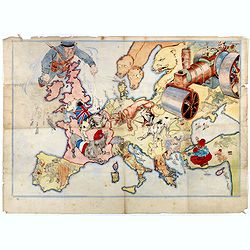
(Design for Hark ! Hark ! The dogs do bark.)
This very rare political caricature map of Europe depicts the continent at the outbreak of World War I, or as it was called at the time the Great War. The principal count...
- $3000 / ≈ €2807
Place & Date: London, ca. 1914

Carte d'Europe divisée en ses Empires et Royaumes.
Uncommon and decorative wall map of Europe, prepared by Clouet. Superb decoration including a wonderful rococo border with vignettes describing historical scenes. Below t...
Place & Date: Paris, Mondhare, 1788
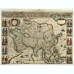
Asia recens Summa cura delineata.
Rare map of Asia published in Pierre d'Avity's "Les Estats Empires, Royaumes, Et Principautez Du Monde". Derivative map of Hondius' rare separately issued map o...
- $3000 / ≈ €2807
Place & Date: Paris, ca. 1659
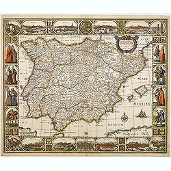
Nova et accurata Tabula Hispaniae. . .
Second state. This "carte à figures"- map of Spain and Portugal shows the geographical image introduced by Hessel Gerritsz's 1612 wall map of Spain. The map is...
Place & Date: Amsterdam, 1633
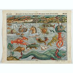
Meerwunder und Seltzame Thier.
A fine detailed woodcut depicting a superb variety of fantastic sea-monsters, such as might be encountered by a sailor in northern waters. Including monsters with abundan...
- $1950 / ≈ €1825
Place & Date: Basel, 1580

.Pascaerte Van't Westelyckste der Middelandsche Zee. . .
An eye-catching chart of the western part of the Mediterranean Sea.Pieter Goos (ca. 1616-1675) was one of the most important cartographer, engraver, publisher and print s...
Place & Date: Amsterdam, 1666

Noordoost Cust van Asia van Japan tot Nova Zembla.
Important for its early depiction of Hokkaido and the Islands to the North of Japan. Ships navigate the seas around the Siberian, Chinese and Japanese coast extending as ...
- $3000 / ≈ €2807
Place & Date: Amsterdam, 1666

Eastern passage to China. sheet 1.
James Horsburgh early chart of the coasts of Java, Bali, Lombok, with part of Sulawesi, and Borneo. Insets of "Sketch of Bally Strait", Sketch of Lombock Strait...
- $2500 / ≈ €2339
Place & Date: London, 1824
![[Map of the Holy Land, Israel, and Palestine.]](/uploads/cache/43037-250x250.jpg)
[Map of the Holy Land, Israel, and Palestine.]
A fine example of the six sheet map by Georgius Hornius map of the Holy Land. Each of the maps is embellished with countless vignettes and other images drawn from Biblica...
Place & Date: Amsterdam, Janssonius, 1662

Mer de Chine - Detroit De Singapour Partie Comprise Entre Singaour et Le Dett. De Malacca d'apres les travaux du Commr. J.W. Reed de la Marine Royale d'Angleterr...
Mer de Chine - Detroit De Singapour Partie Comprise Entre Singaour et Le Dett. De Malacca d'apres les travaux du Commr. J.W. Reed de la Marine Royale d'Angleterr, execute...
- $2500 / ≈ €2339
Place & Date: London, 1871
Madrid Villa Capital Del Reyno D'Espana.. / Madrid ville capitale du Royaume d'Espagne . . .
A very decorative and scarce town view of Madrid, including a numbered key ( 1-17 ) in Spanish and French in the lower part. Published by Jacques Chéreau, (1688 - 1776)....
- $3000 / ≈ €2807
Place & Date: Paris, ca.1750

Nieuwe Wassende Graade Zee Kaart over de Spaanse Zee Vant Kanaal tot 't Eyland Cuba in Westindia. . .
¤ Engraved by I.van Anse. A very representative example of a Dutch chart of the Atlantic, showing the north-east coast of America, the coasts of Africa and Europe and So...
Place & Date: Amsterdam, 1728

Noordoost Cust van Asia van Japan tot Nova Zemla.
An eye-catching chart of Japan, Hokkaido and the Islands to the North of Japan. In the lower left Korea and part of northern China. Korea has three names mentioned: "...
- $2000 / ≈ €1871
Place & Date: Amsterdam, 1666
![[2 maps] Das Europa der Zukunft... / Das heutige Europa…[The Europe of the Future / The Europe of Today]](/uploads/cache/48735-250x250.jpg)
[2 maps] Das Europa der Zukunft... / Das heutige Europa…[The Europe of the Future / The Europe of Today]
A pair of very scarce WWI German maps highlighting Europe as it currently was, and Europe as it may become. The maps were produced as part of an 8 page booklet produced b...
- $2750 / ≈ €2573
Place & Date: Paris, 1917

Mare Balticum. . . / Nieuwe Pascaert van de Oost Zee. . .
Decorative chart showing the Baltic sea, with a splendid cartouche of royal figures. A re-issue of the De Wit copper plates, now with many improvements.
- $2500 / ≈ €2339
Place & Date: Amsterdam ca.1680

De custen van een deel van Denemarken en Swede. . .
A detailed chart of the coast Skane and Kalmar, with the island Öland. Decorated by a title and scale cartouche, a compass rose, several vessels and sea monsters, and de...
- $2000 / ≈ €1871
Place & Date: Leiden, Plantijn, 1585
Barcelone, Ville Capitale de la principauté Catalogne. . .
A very decorative and scarce view of Barcelona, including a numbered key ( 1-29 ) in the lower part. Published by Jacques Chéreau, (1688 - 1776). Engraved by Aveline and...
- $2000 / ≈ €1871
Place & Date: Paris, ca.1750
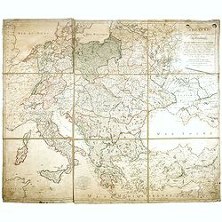
THEATRE Géographique des Guerres du Continent, OU SE TROUVENT EN ENTIER Les Royaumes de Hollande, ...
Large wall map of Central Europe, centered on Poland and including present-day Germany, the Low Countries, Italy, Greece, Bulgaria, Turkey and the Black Sea in the lower ...
- $2000 / ≈ €1871
Place & Date: Paris, Paul-André Basset, 1806
Seville. Ville Archiepiscopale et Capitale du Raume d'Andalousie en Espagne. . .
A very decorative and extremely rare view of Seville, including a numbered (1-37) key in the lower part. Published by Jacques Chéreau, (1688 - 1776). Engraved by Aveline...
- $2000 / ≈ €1871
Place & Date: Paris, ca.1750

Pascaerte van Carybes, Nieu Neder landt, Brazil. . .
This progenitor chart covers the American shores of the Atlantic Ocean. This chart by Theunis Jacobsz. was most probably engraved close to his death in 1650 or shortly af...
- $2200 / ≈ €2059
Place & Date: Amsterdam, 1653-1681
Mer de Chine - Carte des Iles et Détroits entre Singapoure et le Détroit de Banca. Dréssée d'après le stravaux Anglais et Hollandais plus récents, par Mr. L. Manen . . . 1866
A nautical chart of Singapore and neighboring islands. The first edition of the chart was published in 1866 from French and English sources, this is the corrected version...
- $2000 / ≈ €1871
Place & Date: London, 1866-1871

Caerte der Noordt cufte van Engelandt, beginnende van Robinhodes baij tot Coket Eijlandt. . . .
A very early Dutch text edition of this detailed chart of the northern coast of England. The mileage cartouche has no Latin captures. West to the top.Decorated by a color...
- $2000 / ≈ €1871
Place & Date: Leiden, Plantijn, 1585
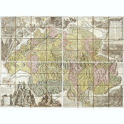
Nova Helvetiae tabula geographica . . .
Johann Jakob Scheuchzer (August 2, 1672 – June 23, 1733) was a Swiss scholar born at Zürich. In 1712 he published, a map of Switzerland in four sheets (scale 1/290,000...
- $1750 / ≈ €1638
Place & Date: Amsterdam, 1712
De custen van Noorwegen, Finmarcken, Laplandt, Spitsbergen . . .
Two sea charts on one sheet showing Norway, Finland, Iceland, Spitsbergen and part of Scotland. The chart includes a detailed plan of the coastlines, soundings, anchorage...
Place & Date: Amsterdam, 1666

Nieuwe Wassende Graade Zee Kaart over de Spaanse Zee Vant Kanaal tot 't Eyland Cuba In Westindia.
Rare two-sheet blue-back sea chart of the Atlantic and Eastern part of North America., published by Gerard Van Keulen. The map extends from the latitude of Newfoundland a...
- $2000 / ≈ €1871
Place & Date: Amsterdam, ca. 1728-1751

A new mape of Ye XVII Provinces of Low Germanie.
Showing all 17 Provinces of the Netherlands before the split between Spain and the Protestant Provinces under the House of Orange.The map was first published. At the same...
Place & Date: London, 1676
Asiae Nova Descriptio.
General map of Asia, highlighted with gold. This is a very attractive example of a much sought-after map. In the upper left corner, a coat of arms with a dedication to D....
- $1500 / ≈ €1404
Place & Date: Amsterdam, ca. 1660

Nieuwe gemeten kaart van de colonie de Berbice : met der zelver plantagien en de namen der bezitters in het ligt gebragt door Reiner & Iosua Ottens kaartverkopers te Amsterdam 1740.
Rare separately published map of the colony of Berbice in present-day Guyana showing the Berbice River Valley and the plantations along the river. North on map of the col...
Place & Date: Amsterdam, 1740
![[Title page] Le Nouveau Theatre du Monde.](/uploads/cache/47951-250x250.jpg)
[Title page] Le Nouveau Theatre du Monde.
The fine engraved frontispiece by F. Bleiswyk entitled "Le Nouveau Theatre du Monde" for Pieter van der AA. Shows Atlas carrying the world on his shoulders acco...
Place & Date: Leiden, 1713
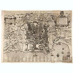
Palermo.
Rare bird's-eye view of Palermo, the plan showing the city and harbor within the city walls, with the surrounding countryside, title and dedicatory verse set in elaborate...
- $3000 / ≈ €2807
Place & Date: Seina, ca. 1600
Pascaerte van Groen-Landt, Yslandt, Straet Davids en Ian Mayen eylandt. . .
An eye-catching chart of the North Atlantic, showing prominent Greenland, Iceland, and parts of the North American continent. The map is decorated with a large figurative...
- $2000 / ≈ €1871
Place & Date: Amsterdam, 1666

Pas-Caart van de Oost Zee verthooende alle de ghelegenheydt tusschen t Eylandt Rugen ende Wyborg. . .
An eye-catching chart of the Baltic Sea. Engraved by Gerard Coeck.Pieter Goos (ca. 1616-1675) was one of the most important cartographers, engravers, publishers and print...
- $1500 / ≈ €1404
Place & Date: Amsterdam, 1666

Kaart van de Reede van Batavia met de verschillende vaarwaters naar dezelve trigometrisch opgenomen op last van deb schout bijnacht E.Lucas.
Very large and rare so-called blue-black chart centered on Jakarta's harbor.The chart is prepared by B.G.Escher, I.A.C. Eschauzier, B.H.Staring and E.H.Boom during an exp...
- $2000 / ≈ €1871
Place & Date: Amsterdam (1841) 1847

A plat of the East Sea. By William Fisher and Richard Mount...
An important sea chart of the East Sea with coast lines of Poland, Russia, Sweden, published by William Fisher and Richard Mount in London.Richard Mount (1654-1722) was a...
- $1800 / ≈ €1684
Place & Date: London, 1795
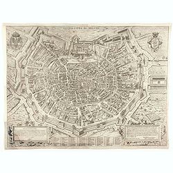
La Gra. Citta di Milano.
Extremely rare city map of Milan. The plan showing the city within the city walls, with the surrounding countryside, title and dedicatory verse set in elaborate strapwork...
- $2000 / ≈ €1871
Place & Date: Rome, 1602
![Praghe. [ Prague ]](/uploads/cache/27801-250x250.jpg)
Praghe. [ Prague ]
A rare panoramic of Prague with over the whole length of the lower part 3 columns of poems in Dutch, French, German and English.Frederick de Wit published after 1694 a t...
- $1500 / ≈ €1404
Place & Date: Amsterdam, 1694
![Madeburga [ Maagdenburg Folio CLXXX ]](/uploads/cache/47601-250x250.jpg)
Madeburga [ Maagdenburg Folio CLXXX ]
Double page panoramic view of Magdeburg. A imaginary view, however the earliest obtainable view of this period.Two page from the richest illustrated Incunable, the famous...
- $2000 / ≈ €1871
Place & Date: Nuremberg, 12 July 1493
Le jeu des Princes de l'empire d'Allemagne par P. du Val. . .
One of Du Val's magnificent sets of game cards, included in his atlas "Cartes de Geographie".Dated 1674. By the Peace of Westphalia (1648) sovereignty was grant...
- $2000 / ≈ €1871
Place & Date: Paris, 1675-1676

Straat Sunda en Westkust van Java.
Very large and rare chart depicting Java's western seacoast close to the Sunda Strait.Showing part of Sumatra on top and the West Java tip, today hosting the Ujung Kulon ...
- $1500 / ≈ €1404
Place & Date: Amsterdam (1841)1846
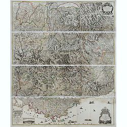
Theatre de la Guerre en Savoie et en Piémont - Le Dauphiné, La Bresse - Partie du Lionnois et de la Provence./ Theatre de la guerre en Dauphiné et en Provence…
Rare wall map of the Savoie/Piémont and Dauphiné/Provence region. Decorated with 2 title-cartouches, one at upper right part (Savoye/Piémont) and one at lower right pr...
- $3000 / ≈ €2807
Place & Date: Amsterdam, c.1735
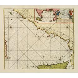
Paskaart der Zeekusten van Italien Tusschen Piombino en C. dell Arme Met de Noord-kust van 't Eylandt Sicilia..
Centered off the Ponziane Islands, this sea chart covers the area of the Tyrrhenian Sea, delimited by Sardinia, the Elba island, the Strait of Messina and Trapani. It con...
- $1500 / ≈ €1404
Place & Date: Amsterdam, 1708

Plan de St. Jean de Luz avec les différents projets d'agrandissem.t du port.
Very rare and beautiful plan of the city and bay of Saint-Jean-de-Luz, detailing the projects of expansion of the port undertaken in 1780.The plan indicates the Artha Roc...
- $2000 / ≈ €1871
Place & Date: Paris, 1784

Pas-Caart van de ZUYDER-ZEE, Texel ende Vlie-stroom.als mede 't Amelander gat (Hollandt/Vrieslandt)
An attractive chart of the Zuiderzee, now the inland water het IJselmeer.HOLLANDT / VRIESLANDTPas-Caart van de Zuyder-Zee, Texel ende Vlie-stroom.als mede 't Amelander g...
- $1200 / ≈ €1123
Place & Date: Amsterdam, c. 1665
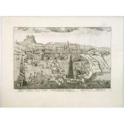
Vue de Cadix.
Very rare view of Cadiz and its seafront drawn and engraved by Renouard, published in Paris by Fatout et Avice, Quai Malaquais, 9. Beautifully hand colored at the time of...
- $1500 / ≈ €1404
Place & Date: Paris, Fatout et Avice, Quai Malaquais 9 , c.1838
Schweet.
Very decorative and rare panoramic town view of Schwedt a.d Oder, Bez. Frankfurt a.d. Oder.The engraver and publisher of prints, Mrs. Anna Beek of the Hague, enlarged the...
Place & Date: The Hague, ca. 1642
Werben.
Very decorative and rare panoramic town view of Werben a.d. Elbe, Bez. Magdeburg.The engraver and publisher of prints, Mrs. Anna Beek of the Hague, enlarged the print and...
Place & Date: The Hague, ca. 1642
![Veduta di Istambul. [Gouache]](/uploads/cache/45368-250x250.jpg)
Veduta di Istambul. [Gouache]
Very decorative view depicting Istanbul, in the style of Neapolitan gouaches. Features different Mosques and the shores of the Bosporus. Many ships, small and large, are ...
Place & Date: Italy ?, ca. 1870
Orientalior districtus Maris Mediterranei.
Beautiful chart of the eastern part of the Mediterranean. Including Italy, the north coast of Africa and part of the Black Sea.The entire sheet is covered with rhumb line...
Place & Date: Amsterdam, 1675
![[2 Sheets] Carte Générale de l'Océan Pacifique Dressée Par Mr. C. A. Vincendon-Dumoulin. . . Pl. 1. N° 1092. / Ocean Pacifique Feuille 2. . . Pl. 2. N° 1093.](/uploads/cache/26731-250x250.jpg)
[2 Sheets] Carte Générale de l'Océan Pacifique Dressée Par Mr. C. A. Vincendon-Dumoulin. . . Pl. 1. N° 1092. / Ocean Pacifique Feuille 2. . . Pl. 2. N° 1093.
Two sea charts depicting the Pacific Ocean, with nice detail of Hawaii. Sheet 1 shows the south east Asian region. The second North America and part of South America. Pre...
- $900 / ≈ €842
Place & Date: Paris, 1845, updated for 1884
Accurata recens delineata ichnographia celeberrimæ liberæ Imperii civitatis ac Sueviæ metropolis Agustæ Vindelicorum -Neu verfertigt accurater ... Haupt Stadt Augspurg.
Superb plan of the fortified town of Augsburg, brilliantly colored at the time, with title in Latin and German. The plan was designed by Johann Thomas Kraus, engraver, ar...
- $1200 / ≈ €1123
Place & Date: Nuremberg, ca. 1740
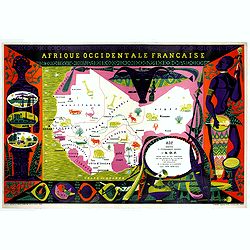
Afrique Occidentale Française AOF.
Beautiful and decorative lithograph pictorial map of Equatorial Africa, showing animals in a beautiful design… Made for Agence de la France d'Outre-Mer. The artist Alai...
- $1100 / ≈ €1029
Place & Date: Imprimerie Raidot, Paris, ca. 1950
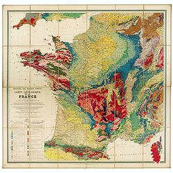
Carte géologique de la France.
Early geological map of France, published by Charles Béranger. Full title: " Ministère des Travaux publics, Carte géologique de la France 1:1'000'000, Exécutée ...
- $1200 / ≈ €1123
Place & Date: Paris, 1905

Géographie des Plantes Equinoxiales - Tableau physique des Andes et pays voisins. . .
Physical Portrait of the Andes and adjacent lands", organized around the Chimborazo and Cotopaxi volcanoes in Ecuador.With local vegetation is illustrated pictoriall...
- $1000 / ≈ €936
Place & Date: Paris, 1805

Paskaart van Guinea van C.Verde tot R. deGalion.
Rare edition of Doncker's sea chart of Guinea coast. From an atlas printed in 1668, "l'Atlas de MER ou MONDE AQUATIQUE, Remontrant toutes lescôtes de la Mer…"...
- $1000 / ≈ €936
Place & Date: Amsterdam, 1660-1668
Carta del Gran Banco de Bahama parte de la Isla de Cuba y Costa de la Florida.
A large marine chart, engraved by Juan Noguera and C.Marquerie, produced by the Direccion de Hydrografia, under the direction of Jose de Quesada, who was the then chief o...
- $1750 / ≈ €1638
Place & Date: Madrid, 1858-1866
Hierosolymia, Clarissima totius Orientis civitas. . .
Two bird's eye perspectives on one sheet. The left plan shows ancient Jerusalem at the time of Christ.A contemporary view of Jerusalem appears to the right with an attrac...
- $900 / ≈ €842
Place & Date: Cologne, 1582
![[Title page] Isolario dell'Atlante Veneto de P. Coronelli, parte I.]](/uploads/cache/47757-250x250.jpg)
[Title page] Isolario dell'Atlante Veneto de P. Coronelli, parte I.]
Very fine engraved architectural frontispieces of "Isolario dell'Atlante Veneto de P. Coronelli, parte I" by Vincenzo Coronelli, in 1696.More about title pages ...
- $900 / ≈ €842
Place & Date: Venice, 1696

Carte réduite de l'Océan Oriental, depuis Le Cap de Bonne Espérance jusqu'à l'Isle Formose.
French chart covering the seas between the Cape of Good Hope until Taiwan and the West Coast of Australia. Prepared by Jacques-François L'Abbé Dicquemare (1733-1789). L...
- $1000 / ≈ €936
Place & Date: Paris, Brest, chez Demonville, 1775
![[Title page] Le Nouveau & Grand Illuminant Flambeau de la Mer. La troisième partie. …Par Nicolas Jans Vooght.](/uploads/cache/47950-250x250.jpg)
[Title page] Le Nouveau & Grand Illuminant Flambeau de la Mer. La troisième partie. …Par Nicolas Jans Vooght.
Allegoric frontispiece of the third edition of the "Zee-Fakkel" with French text. The "4" from the date 16"89" is in manuscript.
Place & Date: Amsterdam, 1689
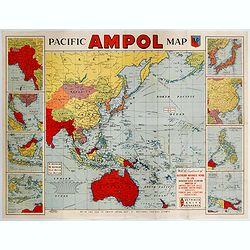
Pacific AMPOL Map
A large and very colorful World War II era map of the Pacific Ocean produced with the complements of the Australian Motorists Petrol Co. Ltd. The map itself shows the Pac...
- $1000 / ≈ €936
Place & Date: Australia, ca 1942
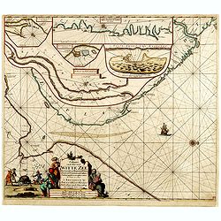
Paskaart van de Mont van de Witte Zee,. Beginnende van Tiepena tot Pelitza, als mede van C. Cindenoes tot Catsnoes.
Fine sea chart of the southern part of the Barents Sea, oriented to the West. With 5 inset maps: - Swetenoes, de Kust van Laplandt, Lombascho, "T Vaste Landt van Lap...
- $1000 / ≈ €936
Place & Date: Amsterdam, c.1710
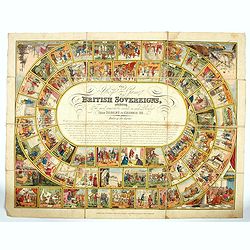
The Royal Game of British Sovereigns Exhibiting the Most Remarkable Events in Each Reign From Egbert to George III,
Engraved goose game with 53 illustrations culminating in a view of Napoleon on the Bellerophon, four further spandrel vignettes, and a central oval filled with title and ...
- $900 / ≈ €842
Place & Date: London, ca. 1817
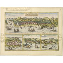
Calechut Celeberri mum Indiae Emporium/ Ormus/ Canonor, St.Georgii.
Four panoramic town-views on one sheet: The upper approximately two-thirds of this double page sheet contains a fine panoramic view of Calicut which is on the west coast ...
- $750 / ≈ €702
Place & Date: Cologne, 1580
Nova Hispaniae, Chili, Peruviae, et Guatimalae Littorae..
A superbly decorative chart, oriented with north to the left of the sheet, covering the coasts of Central America, Peru, Chile, Jamaica and part of Cuba and Porto Rico. S...
- $1000 / ≈ €936
Place & Date: Amsterdam, 1660
Pas-Caart van Hispangien vertoonde de Custen van Granade…
An eye-catching chart of Spain and Portugal, including a large part of Brittany and the southwestern coast of France, including Isle de Reé , Isle Saint Martin ...Pieter...
Place & Date: Amsterdam, 1669-1676
Plan de la ville de Rome, d'après celui publié par J.B. Nolli . . .
Beautiful town-plan of Rome, drawn up after the famous plan of Rome, executed by Giambattista Nolli in 1748. Decorated with a beautiful title cartouche topped by the coat...
- $1000 / ≈ €936
Place & Date: Paris, Jean, 1801
![[Title page] Atlas Novus ad Usum Serenissimi Burgundiae Ducis.](/uploads/cache/28073-250x250.jpg)
[Title page] Atlas Novus ad Usum Serenissimi Burgundiae Ducis.
Soldiers, savages and other individuals are shown approaching a queen seated on her throne. In the upper right corner, Atlas is shown holding up the world. In the sky, a ...
Place & Date: Amsterdam c. 1745
Selling price: $800
Sold in 2009
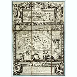
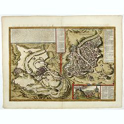
Plan de la ville de Roses avec les attaques.
Very rare and beautiful plan engraved by Pierre Lepautre, of the city of Roses in Catalonia, and celebrating the victory and capture of the city by Louis XIV in June 1693...
- $1500 / ≈ €1404
Place & Date: Paris, 1700
Hierosolymia, Clarissima totius Orientis civitas. . .
Two bird's eye perspectives on one sheet. The left plan shows ancient Jerusalem at the time of Christ. A contemporary view of Jerusalem appears to the right with an attra...
Place & Date: Cologne, 1582
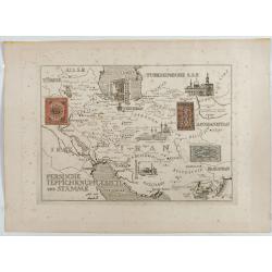
Persische Teppichknüpfgebiete und Stämme.
Map of Iran and neighboring countries in German language, published in limited edition probably in France : "Gravée à l'eau-forte et au burin. Edition limitée&quo...
Place & Date: France ?, after 1935 - before 1991

Paskaerte Vande Bocht van Vranckrijk Biscajen en Galissen
An eye-catching chart of Spain and France, including a large part of Brittany, including Isle de Reé , Isle Saint Martin ...Shows the gulf of the northeast Atlantic Ocea...
Place & Date: Amsterdam, 1669-1676

Beschrijvinge vande de zee Cuften va Vlanderen en Picardien. . .
A detailed description of the coast of Picardie and Normandy decorated by a large colored baroque title cartouche, and the coat of arms of Flanders with a colorful scale ...
- $1750 / ≈ €1638
Place & Date: Amsterdam, 1585